

Our Services
3D Site Survey for Engineering: From Field Data to Project Decisions
What if a project’s biggest risk is not the design, but assumptions about the site before work begins? In Dubai and across the UAE, engineering teams may need to understand ground levels, existing structures, visible features, or underground utilities before planning work. A 3D site survey for engineering provides spatial information about selected site conditions, helping teams make decisions using captured data rather than incomplete assumptions.
The right capture method depends on the site and the information the team needs. Topographic Mapping and Land Survey can document terrain and mapped features. 3D scanning can record the form of existing structures, drone-based capture can provide aerial data, and Utility Mapping (GPR) can address subsurface assets when they are relevant to the project.
This article explains how to define a practical survey scope, compare capture methods, and review the handover. It also covers why deliverables should be planned around the engineering workflow: field data is most useful when the receiving team knows what it covers and how it relates to the project.
Key Takeaways
- Define the survey scope around the project decisions it needs to support, such as site planning, construction coordination, or asset planning.
- A 3D site survey for engineering records selected site conditions as spatial information. Engineers use that information as an input to their work.
- Match the capture method to the information need: Topographic Mapping, Land Survey, 3D scanning, drone survey, or Utility Mapping (GPR).
- Agree site limits, access, required features, and deliverables with the engineering, construction, and asset teams before capture begins.
- GEOTECH 3D provides GIS & Surveying Services for projects in Dubai and across the UAE.
What Is a 3D Site Survey for Engineering in Dubai?
A 3D site survey for engineering captures and maps selected existing site conditions so engineers and project teams can use them as spatial information for defined tasks. Depending on the brief, the scope may include terrain, visible features, structures, or other site context. The survey records and presents information; engineers interpret it and make design decisions, while contractors plan and carry out construction.
Working definition: An engineering site survey is a project-scoped record of relevant existing conditions. “3D” describes how spatial information may be captured or represented, not the purpose of the survey.
That distinction matters in Dubai and across the UAE, where project requirements vary. A development plot may need terrain and mapped site features for planning. An infrastructure corridor may need information to help coordinate proposed works with existing features. An industrial or construction site may need a spatial record of selected structures and their surroundings. Start with the engineering brief, rather than assuming the same survey scope suits every site.
Survey information is an input to engineering work, not a substitute for it. A site survey can document visible conditions and spatial relationships, but it does not establish ground or subsurface properties simply by recording site geometry. Geotechnical investigation addresses different questions about ground conditions.
What site information can an engineering survey document?
Depending on the brief, relevant information may include ground levels and terrain, visible site features, existing structures, and how these relate to the project area. Topographic Mapping can document terrain and specified mapped features. Land Survey can provide survey information relevant to planning and engineering coordination. The scope should identify which features matter, rather than assuming every project needs a complete record of the site.
Set coverage according to the decisions the team needs to make. A project brief might prioritise terrain around a proposed work area, selected visible features, or the surroundings of an existing structure. Define the site limits and required information before capture so the survey is aligned with its intended use.
How is a 3D site survey different from a basic site plan?
A basic site plan is usually a simplified representation created for a particular purpose. A survey scoped around engineering questions can capture and organise relevant site information for coordination and assessment. Where the scope calls for it, 3D methods add spatial context. 3D scanning technology, for example, captures physical form to create digital 3D representations.
More dimensions alone do not make a dataset suitable for a project. Coverage, level of detail, accuracy requirements, and outputs depend on the brief. Agreeing these needs before capture helps the team understand what the survey can support and where engineering judgement or other investigations are still needed.
How 3D Survey Data Moves from Site Capture into Engineering
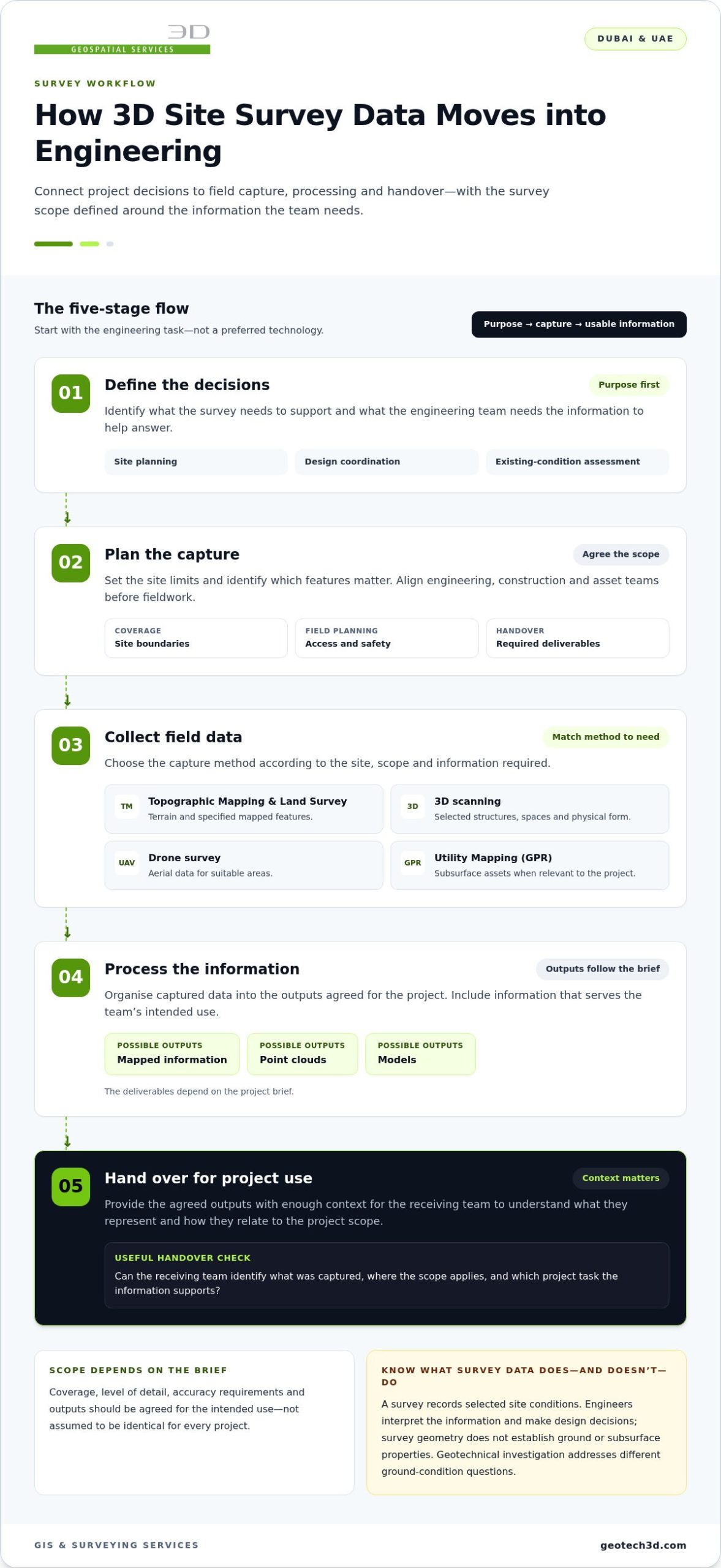
Survey data becomes useful when the project team can connect what was captured to a defined engineering task. The workflow involves more than choosing a scanner or drone. It links project decisions, field planning, data capture, processing, and handover so the information can be interpreted in the intended workflow.
Useful survey data starts with a clear purpose. For a 3D site survey for engineering, agree what the team needs to assess or coordinate before selecting capture methods and deliverables.
- Define the decisions. Identify whether the survey will support site planning, design coordination, assessment of existing conditions, or another project task. State the questions the engineering team needs the information to help answer.
- Plan the capture. Set site limits, identify relevant features, and discuss access and safety considerations with the project team. Agree which information is essential and what the handover should contain.
- Collect field data. Select methods to suit the site and scope. 3D scanning can document selected structures and spaces, while drone survey can collect aerial data for suitable areas. Mapping can focus on terrain and other specified site features.
- Process the information. Organise the captured data into the outputs agreed for the project. Depending on the brief, these may include mapped information, point clouds, or models. Include outputs that serve the team’s intended use.
- Hand over for project use. Provide the agreed outputs with enough context for the receiving team to understand what they represent and how they relate to the project scope.
Plan the survey around engineering questions
Begin with the decisions the project team needs to make, not a preferred technology. A team coordinating proposed work with an existing structure may need spatial information about selected structural features. A site-planning task may prioritise terrain and mapped features. These different information needs may require different capture plans.
Before fieldwork, align engineering, construction, and asset teams on boundaries, access, relevant features, and deliverables. This helps separate essential capture from extra detail that will not inform a current decision. GEOTECH 3D’s GIS and surveying services support project teams with survey inputs scoped to their requirements.
Coordinate field capture, processing, and handover
Method selection depends on site conditions and the information required. 3D scanning, drone-based capture, and mapping each provide different forms of spatial information. Processing organises those data for the agreed engineering workflow, rather than adding outputs without a defined purpose.
Specify the receiving workflow and deliverables early. File formats, coordinate references, control requirements, and technical tolerances are project-specific, so establish them in the brief. This reduces assumptions at handover and gives the engineering team a clear basis for using the survey information.
Which Engineering Site Survey Method Fits the Project?
Choose a method based on the information the engineering team needs, not on a preferred device. A project may need terrain mapping, spatial documentation of existing structures, aerial coverage, or information about underground assets. Each method addresses a different part of the site. A combination may suit a scope that needs several types of information.
| Engineering need | Relevant method | Typical information |
|---|---|---|
| Understand terrain and mapped site features | Topographic Mapping | Selected ground levels, terrain, and visible features specified in the brief |
| Establish land and site context for planning | Land Survey | Survey information relevant to the project area and its coordination needs |
| Document the spatial form of existing structures | 3D scanning | Captured spatial information that may be processed into a point cloud or other agreed output |
| Collect aerial information across a suitable site | Drone survey, including Digital Photogrammetry Services | Aerial data for mapping or site context, as defined by the scope |
| Consider subsurface assets during planning | Utility Mapping (GPR) | Subsurface utility information to support coordination and planning |
When do topographic mapping, scanning, and drone survey fit?
Topographic Mapping and Land Survey are relevant when a team needs terrain or mapped site features for planning and coordination. For a project focused on an existing structure, 3D scanning can document its spatial form. Drone-based survey can collect aerial data for suitable areas. The brief, access, and site conditions guide the choice.
These methods are not interchangeable. A site with terrain, structures, and wider surroundings may call for a combination, while a focused engineering question may require only one method. Identify the features and outputs the project needs so capture remains purposeful. No single method should be treated as a replacement for all the others.
When should underground utilities be considered?
Surface mapping describes visible site conditions; it does not provide the same information as subsurface utility mapping. Utility Mapping (GPR) addresses underground asset information that may be relevant when planning works near existing services or coordinating a proposed design with site conditions. Including it in the survey scope can help teams consider above-ground and underground information together.
Utility requirements depend on the project question and available site information. If existing services could affect layout or coordination, include them in the scope discussion. GEOTECH 3D’s utility mapping services use Ground Penetrating Radar to locate and map underground assets. For a 3D site survey for engineering, select the methods that answer the project’s questions rather than adding every method by default.
How to Scope and Review a 3D Engineering Site Survey
A clear scope helps the survey team capture information the project can use. For a 3D site survey for engineering, define the purpose before fieldwork: which decisions or coordination tasks should the information support, who will use it, and what should the handover include? Align engineering, construction, and asset teams so the brief reflects project requirements rather than assumptions.
Review survey delivery against the agreed outputs and their intended use. A detailed dataset is not automatically suitable for every workflow. Check whether the specified information is present, clearly organised, and usable for the tasks it was commissioned to support.
What should the project brief define?
Record the project objective, site boundaries, relevant assets, access arrangements, and safety coordination needed for fieldwork. Identify the intended users and the engineering or planning tasks the survey should support. This gives the scope a practical basis and helps distinguish required information from optional capture.
Use a checklist to align the brief before capture begins:
- Purpose and users: State the project questions and identify the engineering, construction, or asset teams who will use the information.
- Coverage: Define site limits and specify the areas, terrain, structures, or other features to include.
- Access and coordination: Document site access arrangements and coordinate relevant safety considerations with the project team.
- Handover: Describe the required deliverable types and the workflow they need to support.
- Technical requirements: Agree coordinate references, tolerances, and file formats for the project. Do not leave these requirements to assumption.
How can teams assess survey data after handover?
Review the delivered information against the agreed scope, not an unstated expectation of complete site documentation. Check that the specified areas and features are represented, and that the files are organised and described for the intended workflow. If a requirement changes, record the change so the review reflects the current brief.
- Compare delivered coverage with the defined site limits and required features.
- Confirm the supplied outputs match the agreed deliverable types.
- Check that file organisation and descriptions help the receiving team identify and use the information.
- Record gaps, exclusions, or scope changes for resolution within the project team.
This review gives engineers, contractors, and asset teams a shared basis for deciding whether the survey information is ready for its intended use. It also helps distinguish a delivery issue from a new requirement that was not part of the original scope.
GEOTECH 3D Engineering Site Survey Support in Dubai and the UAE
Engineering teams need existing-condition information that supports the decisions ahead, whether they are planning a development, coordinating construction, or recording assets. GEOTECH 3D provides GIS & Surveying Services for projects in Dubai and across the UAE. The survey scope can be shaped around the site and intended use, with methods selected for the information the team needs.
Survey data supports engineering work but does not replace design or project decisions. Coordinating the survey scope with the receiving team’s workflow helps make the information relevant and practical to use.
Survey capabilities for engineering projects
GEOTECH 3D’s survey services address different information needs. The project brief guides which services fit together and what information the team should receive.
- Topographic Mapping documents mapped terrain and site features relevant to planning and coordination.
- Land Survey supports project requirements for land and site survey information.
- Digital Photogrammetry Services provide aerial data through drone-based capture where suitable for the site and scope.
- 3D scanning supports spatial documentation of existing structures when required by the scope.
- Utility Mapping (GPR) provides subsurface utility information when underground assets are relevant to planning or coordination.
These services can be coordinated when a project needs several types of information, such as mapped site features alongside structural or subsurface context. A focused requirement may instead call for a narrower scope. GEOTECH 3D’s company profile describes professional registration and licensing, and emphasises safety compliance and schedule awareness in project delivery. These considerations inform fieldwork planning and coordination.
Plan a project conversation in Dubai or the UAE
Start with a concise project brief. Share the site location, current project stage, intended use of the survey information, and the questions the engineering or asset team needs to address. Identify relevant areas or assets, site access considerations, and the intended recipients of the deliverables. This context helps align the survey scope and capture approach with project requirements.
Separate current requirements from possible future needs. A team may need terrain information for planning now, while structural documentation or utility context may relate to a separate coordination task. Defining priorities helps GEOTECH 3D shape a project-specific survey scope instead of treating every method as essential. Agree coordinate references, formats, and technical tolerances for the project.
For engineering survey support in Dubai and across the UAE, GEOTECH 3D surveying services can be scoped around your project’s information needs. Share the site context and intended use to discuss the survey scope and capture approach.
Give Your Next Engineering Decision a Clearer Starting Point
Project requirements can change as a site moves from early planning into detailed design, construction coordination, or asset management. Treat survey information as a decision-support resource: keep its intended use clear, identify changes in the project’s information needs, and plan further capture around those changes. This maintains a practical connection between existing conditions and the work the team is preparing to undertake.
A well-scoped 3D site survey for engineering gives the project team a clear basis for discussing site conditions and coordinating next steps. Its value lies not simply in collecting more data, but in making sure relevant information reaches the people who need it in a usable form. GEOTECH 3D provides survey services for projects in Dubai and across the UAE, with the scope aligned to the site and project stage.
Share your project requirements with GEOTECH 3D to discuss a 3D site survey scope for your engineering team.
Frequently Asked Questions
What is a 3D site survey for engineering?
A 3D site survey for engineering provides spatial information engineers can use to compare proposed work with selected existing conditions. For example, a team considering changes to an existing facility may need to understand how its geometry relates to adjacent elements. The survey scope should identify the decision and relevant areas. The information supports professional assessment, but does not verify structural performance or determine whether a design is suitable.
What is the difference between a topographic survey and a 3D site survey?
A topographic survey focuses on terrain and mapped features, while “3D site survey” describes a broader project scope that may include other spatial information. The useful distinction is the required engineering output, not the label alone. Establish whether the design team needs mapped ground information, a spatial record of selected structures, or both. This makes it easier to assess whether the proposed scope addresses the project’s questions.
When should engineers use 3D laser scanning for a site survey?
Consider 3D laser scanning when engineers need spatial documentation of complex existing geometry, such as structural elements in a refurbishment area. Field planning should consider visibility: surfaces need to be captured from suitable positions, and obstructions can limit what is recorded. Identify priority areas and restricted spaces in advance so the capture plan focuses on the parts of the structure relevant to the engineering task.
Can a drone be used for an engineering site survey in Dubai?
Drone-based capture can suit projects where aerial data would help the team assess a wider area. Its usefulness depends on the site layout and information required. Buildings, structures, and other obstructions may limit views of features below. For a Dubai project, include the intended survey area and site conditions in the scope discussion so the method is planned around what the team needs to observe.
Should underground utilities be included in a 3D site survey?
Include utility information when proposed works could interact with existing buried assets. Existing utility records available to the project team can provide context for planning a Utility Mapping (GPR) scope. Identify records and field-collected information as distinct inputs in project coordination. This helps engineers understand the basis of the information they are reviewing without assuming every service has been identified or verified.
What should an engineering site survey deliver?
The handover should include the outputs agreed for the project and enough information to explain their scope. Project teams can check that file names and descriptions are clear, that represented areas are identified, and that agreed exclusions or relevant limitations are noted. This helps prevent a model or dataset from being interpreted as covering more than was captured. The receiving team can then relate the information to its task and raise specific questions about its use.
How do you prepare for an engineering site survey?
Gather existing site drawings or records the project team considers relevant, and identify where they may be incomplete or outdated. Confirm who will coordinate site access and flag active work zones or restricted areas during planning. If several disciplines will use the results, appoint a project contact to consolidate their priorities. This gives the survey discussion a focused starting point and helps avoid conflicting instructions.

What if a project’s biggest risk is not the design, but assumptions about the site before work begins? In Dubai and across the UAE, engineering teams may need to understand ground levels, existing structures, visible features, or underground utilities before planning work. A 3D site survey for engineering provides spatial information about selected site conditions, helping teams make decisions using captured data rather than incomplete assumptions.
The right capture method depends on the site and the information the team needs. Topographic Mapping and Land Survey can document terrain and mapped features. 3D scanning can record the form of existing structures, drone-based capture can provide aerial data, and Utility Mapping (GPR) can address subsurface assets when they are relevant to the project.
This article explains how to define a practical survey scope, compare capture methods, and review the handover. It also covers why deliverables should be planned around the engineering workflow: field data is most useful when the receiving team knows what it covers and how it relates to the project.
Key Takeaways
- Define the survey scope around the project decisions it needs to support, such as site planning, construction coordination, or asset planning.
- A 3D site survey for engineering records selected site conditions as spatial information. Engineers use that information as an input to their work.
- Match the capture method to the information need: Topographic Mapping, Land Survey, 3D scanning, drone survey, or Utility Mapping (GPR).
- Agree site limits, access, required features, and deliverables with the engineering, construction, and asset teams before capture begins.
- GEOTECH 3D provides GIS & Surveying Services for projects in Dubai and across the UAE.
What Is a 3D Site Survey for Engineering in Dubai?
A 3D site survey for engineering captures and maps selected existing site conditions so engineers and project teams can use them as spatial information for defined tasks. Depending on the brief, the scope may include terrain, visible features, structures, or other site context. The survey records and presents information; engineers interpret it and make design decisions, while contractors plan and carry out construction.
Working definition: An engineering site survey is a project-scoped record of relevant existing conditions. “3D” describes how spatial information may be captured or represented, not the purpose of the survey.
That distinction matters in Dubai and across the UAE, where project requirements vary. A development plot may need terrain and mapped site features for planning. An infrastructure corridor may need information to help coordinate proposed works with existing features. An industrial or construction site may need a spatial record of selected structures and their surroundings. Start with the engineering brief, rather than assuming the same survey scope suits every site.
Survey information is an input to engineering work, not a substitute for it. A site survey can document visible conditions and spatial relationships, but it does not establish ground or subsurface properties simply by recording site geometry. Geotechnical investigation addresses different questions about ground conditions.
What site information can an engineering survey document?
Depending on the brief, relevant information may include ground levels and terrain, visible site features, existing structures, and how these relate to the project area. Topographic Mapping can document terrain and specified mapped features. Land Survey can provide survey information relevant to planning and engineering coordination. The scope should identify which features matter, rather than assuming every project needs a complete record of the site.
Set coverage according to the decisions the team needs to make. A project brief might prioritise terrain around a proposed work area, selected visible features, or the surroundings of an existing structure. Define the site limits and required information before capture so the survey is aligned with its intended use.
How is a 3D site survey different from a basic site plan?
A basic site plan is usually a simplified representation created for a particular purpose. A survey scoped around engineering questions can capture and organise relevant site information for coordination and assessment. Where the scope calls for it, 3D methods add spatial context. 3D scanning technology, for example, captures physical form to create digital 3D representations.
More dimensions alone do not make a dataset suitable for a project. Coverage, level of detail, accuracy requirements, and outputs depend on the brief. Agreeing these needs before capture helps the team understand what the survey can support and where engineering judgement or other investigations are still needed.
How 3D Survey Data Moves from Site Capture into Engineering
Survey data becomes useful when the project team can connect what was captured to a defined engineering task. The workflow involves more than choosing a scanner or drone. It links project decisions, field planning, data capture, processing, and handover so the information can be interpreted in the intended workflow.
Useful survey data starts with a clear purpose. For a 3D site survey for engineering, agree what the team needs to assess or coordinate before selecting capture methods and deliverables.
- Define the decisions. Identify whether the survey will support site planning, design coordination, assessment of existing conditions, or another project task. State the questions the engineering team needs the information to help answer.
- Plan the capture. Set site limits, identify relevant features, and discuss access and safety considerations with the project team. Agree which information is essential and what the handover should contain.
- Collect field data. Select methods to suit the site and scope. 3D scanning can document selected structures and spaces, while drone survey can collect aerial data for suitable areas. Mapping can focus on terrain and other specified site features.
- Process the information. Organise the captured data into the outputs agreed for the project. Depending on the brief, these may include mapped information, point clouds, or models. Include outputs that serve the team’s intended use.
- Hand over for project use. Provide the agreed outputs with enough context for the receiving team to understand what they represent and how they relate to the project scope.
Plan the survey around engineering questions
Begin with the decisions the project team needs to make, not a preferred technology. A team coordinating proposed work with an existing structure may need spatial information about selected structural features. A site-planning task may prioritise terrain and mapped features. These different information needs may require different capture plans.
Before fieldwork, align engineering, construction, and asset teams on boundaries, access, relevant features, and deliverables. This helps separate essential capture from extra detail that will not inform a current decision. GEOTECH 3D’s GIS and surveying services support project teams with survey inputs scoped to their requirements.
Coordinate field capture, processing, and handover
Method selection depends on site conditions and the information required. 3D scanning, drone-based capture, and mapping each provide different forms of spatial information. Processing organises those data for the agreed engineering workflow, rather than adding outputs without a defined purpose.
Specify the receiving workflow and deliverables early. File formats, coordinate references, control requirements, and technical tolerances are project-specific, so establish them in the brief. This reduces assumptions at handover and gives the engineering team a clear basis for using the survey information.
Which Engineering Site Survey Method Fits the Project?
Choose a method based on the information the engineering team needs, not on a preferred device. A project may need terrain mapping, spatial documentation of existing structures, aerial coverage, or information about underground assets. Each method addresses a different part of the site. A combination may suit a scope that needs several types of information.
| Engineering need | Relevant method | Typical information |
|---|---|---|
| Understand terrain and mapped site features | Topographic Mapping | Selected ground levels, terrain, and visible features specified in the brief |
| Establish land and site context for planning | Land Survey | Survey information relevant to the project area and its coordination needs |
| Document the spatial form of existing structures | 3D scanning | Captured spatial information that may be processed into a point cloud or other agreed output |
| Collect aerial information across a suitable site | Drone survey, including Digital Photogrammetry Services | Aerial data for mapping or site context, as defined by the scope |
| Consider subsurface assets during planning | Utility Mapping (GPR) | Subsurface utility information to support coordination and planning |
When do topographic mapping, scanning, and drone survey fit?
Topographic Mapping and Land Survey are relevant when a team needs terrain or mapped site features for planning and coordination. For a project focused on an existing structure, 3D scanning can document its spatial form. Drone-based survey can collect aerial data for suitable areas. The brief, access, and site conditions guide the choice.
These methods are not interchangeable. A site with terrain, structures, and wider surroundings may call for a combination, while a focused engineering question may require only one method. Identify the features and outputs the project needs so capture remains purposeful. No single method should be treated as a replacement for all the others.
When should underground utilities be considered?
Surface mapping describes visible site conditions; it does not provide the same information as subsurface utility mapping. Utility Mapping (GPR) addresses underground asset information that may be relevant when planning works near existing services or coordinating a proposed design with site conditions. Including it in the survey scope can help teams consider above-ground and underground information together.
Utility requirements depend on the project question and available site information. If existing services could affect layout or coordination, include them in the scope discussion. GEOTECH 3D’s utility mapping services use Ground Penetrating Radar to locate and map underground assets. For a 3D site survey for engineering, select the methods that answer the project’s questions rather than adding every method by default.
How to Scope and Review a 3D Engineering Site Survey
A clear scope helps the survey team capture information the project can use. For a 3D site survey for engineering, define the purpose before fieldwork: which decisions or coordination tasks should the information support, who will use it, and what should the handover include? Align engineering, construction, and asset teams so the brief reflects project requirements rather than assumptions.
Review survey delivery against the agreed outputs and their intended use. A detailed dataset is not automatically suitable for every workflow. Check whether the specified information is present, clearly organised, and usable for the tasks it was commissioned to support.
What should the project brief define?
Record the project objective, site boundaries, relevant assets, access arrangements, and safety coordination needed for fieldwork. Identify the intended users and the engineering or planning tasks the survey should support. This gives the scope a practical basis and helps distinguish required information from optional capture.
Use a checklist to align the brief before capture begins:
- Purpose and users: State the project questions and identify the engineering, construction, or asset teams who will use the information.
- Coverage: Define site limits and specify the areas, terrain, structures, or other features to include.
- Access and coordination: Document site access arrangements and coordinate relevant safety considerations with the project team.
- Handover: Describe the required deliverable types and the workflow they need to support.
- Technical requirements: Agree coordinate references, tolerances, and file formats for the project. Do not leave these requirements to assumption.
How can teams assess survey data after handover?
Review the delivered information against the agreed scope, not an unstated expectation of complete site documentation. Check that the specified areas and features are represented, and that the files are organised and described for the intended workflow. If a requirement changes, record the change so the review reflects the current brief.
- Compare delivered coverage with the defined site limits and required features.
- Confirm the supplied outputs match the agreed deliverable types.
- Check that file organisation and descriptions help the receiving team identify and use the information.
- Record gaps, exclusions, or scope changes for resolution within the project team.
This review gives engineers, contractors, and asset teams a shared basis for deciding whether the survey information is ready for its intended use. It also helps distinguish a delivery issue from a new requirement that was not part of the original scope.
GEOTECH 3D Engineering Site Survey Support in Dubai and the UAE
Engineering teams need existing-condition information that supports the decisions ahead, whether they are planning a development, coordinating construction, or recording assets. GEOTECH 3D provides GIS & Surveying Services for projects in Dubai and across the UAE. The survey scope can be shaped around the site and intended use, with methods selected for the information the team needs.
Survey data supports engineering work but does not replace design or project decisions. Coordinating the survey scope with the receiving team’s workflow helps make the information relevant and practical to use.
Survey capabilities for engineering projects
GEOTECH 3D’s survey services address different information needs. The project brief guides which services fit together and what information the team should receive.
- Topographic Mapping documents mapped terrain and site features relevant to planning and coordination.
- Land Survey supports project requirements for land and site survey information.
- Digital Photogrammetry Services provide aerial data through drone-based capture where suitable for the site and scope.
- 3D scanning supports spatial documentation of existing structures when required by the scope.
- Utility Mapping (GPR) provides subsurface utility information when underground assets are relevant to planning or coordination.
These services can be coordinated when a project needs several types of information, such as mapped site features alongside structural or subsurface context. A focused requirement may instead call for a narrower scope. GEOTECH 3D’s company profile describes professional registration and licensing, and emphasises safety compliance and schedule awareness in project delivery. These considerations inform fieldwork planning and coordination.
Plan a project conversation in Dubai or the UAE
Start with a concise project brief. Share the site location, current project stage, intended use of the survey information, and the questions the engineering or asset team needs to address. Identify relevant areas or assets, site access considerations, and the intended recipients of the deliverables. This context helps align the survey scope and capture approach with project requirements.
Separate current requirements from possible future needs. A team may need terrain information for planning now, while structural documentation or utility context may relate to a separate coordination task. Defining priorities helps GEOTECH 3D shape a project-specific survey scope instead of treating every method as essential. Agree coordinate references, formats, and technical tolerances for the project.
For engineering survey support in Dubai and across the UAE, GEOTECH 3D surveying services can be scoped around your project’s information needs. Share the site context and intended use to discuss the survey scope and capture approach.
Give Your Next Engineering Decision a Clearer Starting Point
Project requirements can change as a site moves from early planning into detailed design, construction coordination, or asset management. Treat survey information as a decision-support resource: keep its intended use clear, identify changes in the project’s information needs, and plan further capture around those changes. This maintains a practical connection between existing conditions and the work the team is preparing to undertake.
A well-scoped 3D site survey for engineering gives the project team a clear basis for discussing site conditions and coordinating next steps. Its value lies not simply in collecting more data, but in making sure relevant information reaches the people who need it in a usable form. GEOTECH 3D provides survey services for projects in Dubai and across the UAE, with the scope aligned to the site and project stage.
Share your project requirements with GEOTECH 3D to discuss a 3D site survey scope for your engineering team.
Frequently Asked Questions
What is a 3D site survey for engineering?
A 3D site survey for engineering provides spatial information engineers can use to compare proposed work with selected existing conditions. For example, a team considering changes to an existing facility may need to understand how its geometry relates to adjacent elements. The survey scope should identify the decision and relevant areas. The information supports professional assessment, but does not verify structural performance or determine whether a design is suitable.
What is the difference between a topographic survey and a 3D site survey?
A topographic survey focuses on terrain and mapped features, while “3D site survey” describes a broader project scope that may include other spatial information. The useful distinction is the required engineering output, not the label alone. Establish whether the design team needs mapped ground information, a spatial record of selected structures, or both. This makes it easier to assess whether the proposed scope addresses the project’s questions.
When should engineers use 3D laser scanning for a site survey?
Consider 3D laser scanning when engineers need spatial documentation of complex existing geometry, such as structural elements in a refurbishment area. Field planning should consider visibility: surfaces need to be captured from suitable positions, and obstructions can limit what is recorded. Identify priority areas and restricted spaces in advance so the capture plan focuses on the parts of the structure relevant to the engineering task.
Can a drone be used for an engineering site survey in Dubai?
Drone-based capture can suit projects where aerial data would help the team assess a wider area. Its usefulness depends on the site layout and information required. Buildings, structures, and other obstructions may limit views of features below. For a Dubai project, include the intended survey area and site conditions in the scope discussion so the method is planned around what the team needs to observe.
Should underground utilities be included in a 3D site survey?
Include utility information when proposed works could interact with existing buried assets. Existing utility records available to the project team can provide context for planning a Utility Mapping (GPR) scope. Identify records and field-collected information as distinct inputs in project coordination. This helps engineers understand the basis of the information they are reviewing without assuming every service has been identified or verified.
What should an engineering site survey deliver?
The handover should include the outputs agreed for the project and enough information to explain their scope. Project teams can check that file names and descriptions are clear, that represented areas are identified, and that agreed exclusions or relevant limitations are noted. This helps prevent a model or dataset from being interpreted as covering more than was captured. The receiving team can then relate the information to its task and raise specific questions about its use.
How do you prepare for an engineering site survey?
Gather existing site drawings or records the project team considers relevant, and identify where they may be incomplete or outdated. Confirm who will coordinate site access and flag active work zones or restricted areas during planning. If several disciplines will use the results, appoint a project contact to consolidate their priorities. This gives the survey discussion a focused starting point and helps avoid conflicting instructions.
Search Now
Error: Contact form not found.