

Our Services
Comprehensive Guide to Building Façade Laser Scanning in 2026
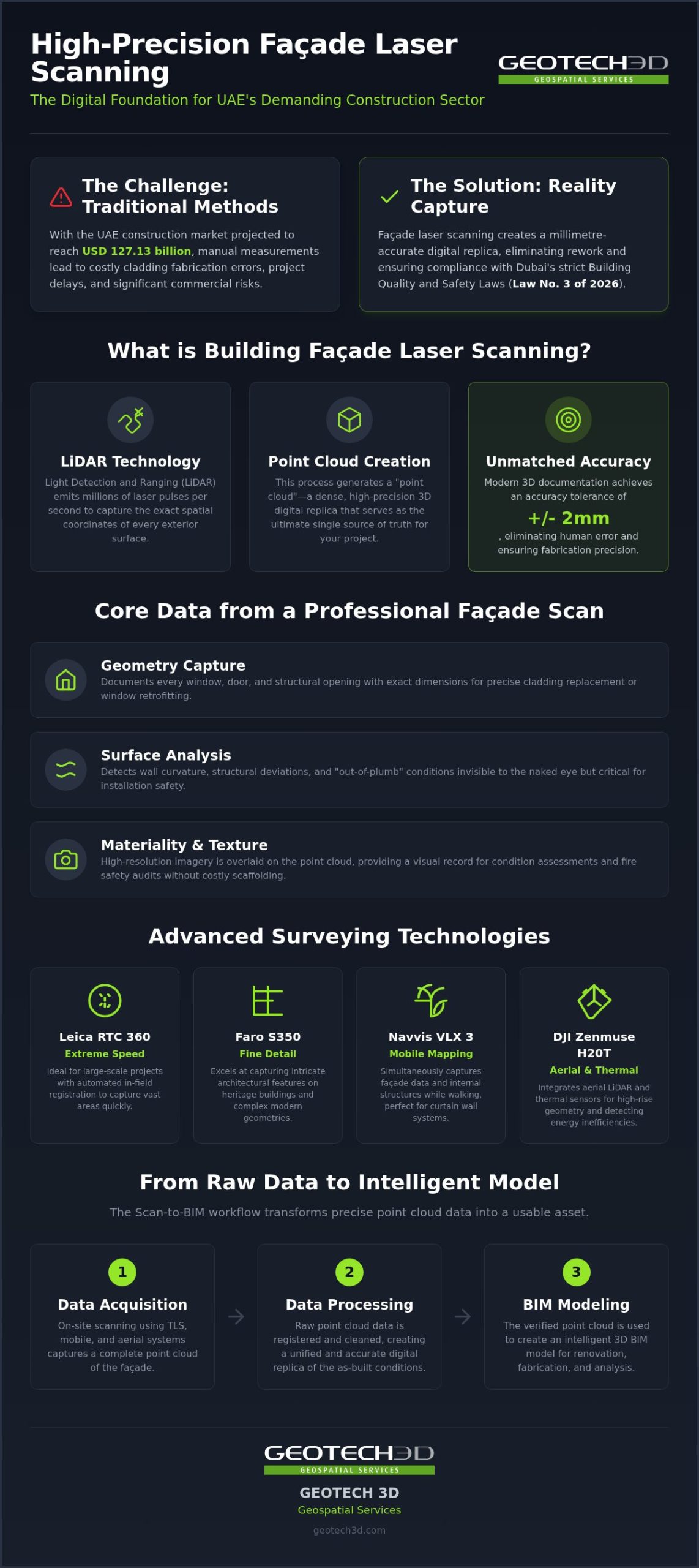
With the UAE construction market projected to reach USD 127.13 billion in 2026, the margin for error in façade execution has effectively vanished. Most developers and contractors understand the frustration of discovering cladding fabrication errors only during installation, often caused by traditional manual measurements that fail to capture the reality of complex geometric designs. In an era where Dubai’s Building Quality and Safety Law (Law No. 3 of 2026) mandates rigorous integrity inspections, relying on outdated survey methods is a significant commercial risk.
This guide explores how high-precision building façade laser scanning transforms documentation and cladding safety across the Emirates. You’ll discover how to eliminate costly rework and ensure regulatory compliance through advanced reality capture. We will examine the transition from expensive scaffolding surveys to sophisticated workflows using the Leica RTC 360 and Navvis VLX 3, detailing how a precise Scan-to-BIM model provides the definitive digital foundation for your renovation or new build project.
Key Takeaways
- Discover how building façade laser scanning creates millimetre-accurate digital replicas of complex structures using advanced LiDAR technology.
- Learn how reality capture ensures compliance with Dubai’s Law No. 3 of 2026 regarding cladding safety and building integrity certification.
- Compare high-precision terrestrial scanners like the Leica RTC 360 with mobile mapping systems to optimize your data collection strategy.
- Explore the Scan-to-BIM workflow that transforms raw point cloud data into intelligent 3D models for seamless renovation and fabrication.
- Gain practical insights into defining project scopes and accuracy requirements to ensure your façade survey delivers maximum value.
What is Building Façade Laser Scanning?
Building façade laser scanning is a sophisticated data acquisition method that utilizes Light Detection and Ranging (LiDAR) to capture the physical characteristics of a building’s exterior with surgical precision. By emitting millions of laser pulses per second, the scanner records the exact spatial coordinates of every surface it touches. This process creates a “point cloud,” a dense, high-precision digital replica that serves as the single source of truth for architects and engineers. Unlike traditional manual surveying, which relies on hand-held tapes and distos, 3D scanning technology eliminates the risk of human error and provides a complete data set in a fraction of the time.
The Evolution of Reality Capture in 2026
In 2026, the UAE construction market has reached a level of digital maturity where reality capture is a core component of the project lifecycle. Dubai’s Building Quality and Safety Law (Law No. 3 of 2026) has further cemented this shift, making detailed façade integrity inspections a legal necessity for building certification. Developers no longer view these surveys as optional expenses. Instead, they’re recognized as essential safeguards against the fabrication errors that once plagued high-rise cladding projects. Modern 3D documentation typically maintains an accuracy tolerance of +/- 2mm, ensuring that every panel and joint is accounted for before fabrication begins. This move toward “as-built” documentation as a mandatory project phase allows for a seamless transition from site reality to the digital design environment.
Key Components of a Façade Scan
A professional scan provides a multi-layered analysis of the building’s envelope, going far beyond simple photography. It provides the technical depth required for complex engineering tasks.
- Geometry Capture: We document every window, door, and structural opening, providing the exact dimensions needed for cladding replacement or window retrofitting.
- Surface Analysis: The data allows for the detection of wall curvature, structural deviations, or “out-of-plumb” conditions that are invisible to the naked eye but critical for installation safety.
- Materiality and Texture: High-resolution imagery is often overlaid on the point cloud. This provides a visual record that supports fire safety audits and allows for detailed condition assessments without the high costs of scaffolding.
The result is a comprehensive dataset that supports every stakeholder, from the facility manager to the lead architect. By capturing the building in its current state, we provide the clarity needed to navigate complex UAE regulations and ensure long-term asset value. This precision is the foundation of modern building façade laser scanning services.
Advanced Technologies for High-Precision Façade Surveys
High-precision building façade laser scanning in 2026 utilizes a hybrid approach. We combine stationary Terrestrial Laser Scanners (TLS) for millimetre-level accuracy with mobile mapping systems for rapid data acquisition. This multi-sensor strategy ensures no detail is missed, from the ground-level retail units to the highest parapets of a Dubai skyscraper. By selecting the right hardware for specific architectural challenges, we provide a dataset that is both comprehensive and technically sound.
Hardware Spotlight: Leica RTC 360 and Faro S350
At GEOTECH 3D, we deploy the Leica RTC 360 for large-scale projects requiring extreme speed. Its automated in-field registration allows our teams to capture vast façade areas without manual alignment delays. For more intricate architectural features, we utilize the Faro S350. This device excels in capturing fine details on heritage buildings or complex modern geometries. Integrating these tools into a guide to 3D laser scanning for renovation in 2026 provides the technical backbone needed for successful retrofitting. Much like the U.S. government’s use of laser scanning for federal building management, our workflows prioritize data integrity and long-term asset documentation.
Aerial and Mobile Integration
Mobile mapping has revolutionized how we document transitions between indoor and outdoor spaces. The Navvis VLX 3 allows our surveyors to walk through a site, capturing façade data and internal structural connections simultaneously. This is particularly useful for documenting curtain wall systems where the connection to the internal slab is critical. For the vertical heights typical of Dubai’s skyline, we integrate aerial LiDAR using the DJI Zenmuse H20T. This payload isn’t just for geometry; it includes thermal sensors to detect “cold spots” or moisture ingress behind cladding panels.
Our ability to capture data over ceilings and in confined spaces ensures that the façade scan is truly comprehensive. We don’t just look at the surface; we analyze the structural context. If you’re planning a complex retrofit, consulting with a reality capture specialist can help define the optimal hardware mix for your specific site conditions. This technological synergy is what sets professional building façade laser scanning apart from basic surveying. It ensures that every project starts with a foundation of absolute precision.
Why Dubai Projects Require Laser Scanned Façade Data
Dubai’s skyline serves as a global benchmark for engineering ambition. In 2026, with a project pipeline valued at approximately $138 billion, the operational and regulatory stakes for façade integrity have reached an all-time high. Building façade laser scanning has transitioned from a specialized service to a foundational requirement for any large-scale development in the UAE. Precision is no longer a luxury; it’s the primary defense against fabrication errors, safety lapses, and the massive costs associated with project delays.
Cladding Verification and Safety Compliance
Cladding systems in the UAE must adhere to rigorous safety standards to mitigate fire risks and ensure structural longevity. We use high-precision scans to audit existing systems, checking for total alignment with Dubai Civil Defence standards. These surveys identify subtle structural deformations or panel shifts that manual visual inspections often overlook. Comprehensive scan data significantly reduces fire risk by providing a precise material map that identifies non-compliant cladding configurations before they lead to safety incidents. By capturing the exact state of a building’s envelope, asset owners can confidently certify their properties under Law No. 3 of 2026, ensuring they meet the latest building quality requirements for legal operation.
Heritage and Landmark Documentation
Beyond modern skyscrapers, the UAE possesses a rich array of cultural landmarks and historic structures that require meticulous care. We provide 3D museum records and detailed data for art and artifact restoration at significant UAE cultural sites. This process creates a “digital twin” of historic facades, preserving every intricate detail for future generations. These digital records allow for precise restoration work if a structure is damaged, ensuring that any new components match the original architectural intent with millimetre accuracy. Integrating these datasets into a 2026 UAE Laser Scanning Guide for Facility Management ensures that historic assets are maintained with the same technological rigor as the newest towers in Dubai South.
Quality assurance remains the final, critical pillar of our work. By comparing “as-built” scan data against the original BIM design, we verify that construction matches the design intent. This eliminates the guesswork in retrofitting and renovation. When new components are fabricated based on a laser scan, they fit perfectly onto aged or complex structures, removing the need for on-site adjustments. This level of coordination is essential for maintaining the high standards of the Dubai property market, where the total value of transactions in early 2026 alone approached AED 177 billion. Professional building façade laser scanning provides the transparency and accuracy required to protect these substantial investments.
From Raw Point Clouds to Scan-to-BIM Deliverables
The value of building façade laser scanning lies in the transition from raw data to actionable engineering intelligence. Once the field work is complete, the massive dataset undergoes a rigorous processing phase. Data integrity is non-negotiable. We clean and register the raw laser data to ensure every scan position is perfectly aligned within a single coordinate system. This results in a unified point cloud that serves as the foundation for all subsequent modeling and analysis.
Scan-to-BIM is the process of converting these point clouds into intelligent 3D models. Unlike a static image, a BIM model contains parametric data, allowing engineers to interact with structural elements as smart objects. We ensure full compatibility with your existing workflows by providing deliverables in industry-standard formats. These include .LGS and .RCP for point cloud viewing, as well as .IFC and native Revit files for seamless integration into your CAD and BIM software packages.
The Scan-to-BIM Workflow
A structured approach is necessary to maintain the integrity of building façade laser scanning data throughout the modeling lifecycle. Our workflow is designed to move from high-speed capture to high-detail delivery with zero data loss.
- Step 1: On-site data acquisition: We utilize a combination of stationary terrestrial scanners and mobile mapping systems to capture every angle of the façade, including shadowed or hard-to-reach areas.
- Step 2: Point cloud registration: Individual scans are stitched together. During this phase, we generate “Bubble Views,” which allow stakeholders to virtually stand at the scanner’s position and view the site in high-resolution 360-degree detail.
- Step 3: Modeling architectural elements: Our BIM specialists build the model according to your specific Level of Development (LOD). This ranges from LOD 200 for basic spatial coordination to LOD 400 for detailed fabrication and assembly information.
Leveraging the Geoverse Platform
For large-scale developments in Dubai South or the Dubai International Financial Centre, managing massive datasets requires a specialized environment. The Geoverse Platform enables city-scale modeling and complex spatial analysis, centralizing façade data for long-term facility management. It provides stakeholders with an accessible Digital Twin, allowing for remote inspections and virtual site visits from any location in the UAE. This transparency ensures that the building’s digital record remains a valuable asset long after the initial renovation or construction is complete.
Implementing Laser Scanning in Your UAE Project
Integrating building façade laser scanning into your project lifecycle is a strategic decision that pays dividends during the pre-construction phase. To ensure the best results, you must first define a clear scope of work. This involves specifying the required Level of Development (LOD) and the millimetre-level accuracy necessary for your specific cladding or renovation goals. In the fast-paced UAE market, where real estate transactions reached nearly AED 177 billion in Q1 2026, there’s no room for vague specifications. A well-defined scope prevents data bloat and ensures you only pay for the precision your project actually requires. By establishing these parameters early, you create a reliable roadmap for all downstream engineering and fabrication tasks.
A robust cost-benefit analysis reveals that the initial investment in 3D scanning is often recovered through the elimination of on-site rework. Fabrication errors in complex façades are notoriously expensive to fix once panels have arrived on-site. By using a precise digital backbone, contractors can identify clashes and misalignments in the virtual environment before a single panel is cut. This proactive approach is essential in 2026, as the UAE construction industry expands by 5% in real terms, demanding higher efficiency and faster turnaround times. Reducing the need for scaffolding-based manual surveys also significantly lowers the overall project risk profile and site insurance costs.
Choosing a Specialist in Dubai
Selecting a geospatial partner in Dubai requires looking beyond basic equipment. You need a team with deep experience in the Middle East’s unique regulatory and environmental conditions. Look for firms that have a proven track record in complex infrastructure and the demanding Oil & Gas sector, as these industries require the highest levels of safety and precision. A true partner doesn’t just hand over raw data; they deliver a refined BIM model ready for immediate use in your design software. They must also demonstrate strict compliance with local safety standards and the ability to meet the tight schedules common in high-profile UAE developments.
Contact GEOTECH 3D for Expert Consultation
As a seasoned veteran in the industry, GEOTECH 3D acts as a faithful guide for asset owners and developers. We combine the wisdom of experience with the energy of technological innovation to deliver high-precision reality capture for the region’s most ambitious projects. Our local presence ensures we’re always available to support your project requirements across the Emirates, providing the technical reassurance needed for complex façade documentation. You can visit our specialists at our local offices:
- Dubai Office: Ilyaa Tower 2 – Office 101, Damascus St., Al Qusais Industrial 3.
- Abu Dhabi Office: Al Shahama Tower 31 – Office 32, Freej Al ‘Teebat St.
Securing the Future of the UAE’s Urban Landscape
As the UAE construction market continues its rapid expansion toward 2026, the digital maturity of your project documentation becomes a decisive factor in its success. High-precision building façade laser scanning is no longer a peripheral service; it’s the core foundation for safety, accuracy, and long-term asset value. By adopting advanced reality capture, you eliminate the risks of fabrication errors and ensure your property remains compliant with evolving fire safety and building integrity regulations in Dubai and across the Emirates.
GEOTECH 3D brings technical authority to every project, utilizing elite hardware like the Leica RTC 360 and Navvis VLX 3 to deliver millimetre-accurate results. Whether you’re documenting a sensitive heritage site or managing complex Oil & Gas facilities, our specialized Scan-to-BIM services transform raw data into intelligent, actionable models. We’re committed to being your faithful guide in this digital transformation, providing the technical certainty you need for the most ambitious architectural designs.
We look forward to partnering with you to secure the future of your building’s envelope with absolute precision and professional integrity.
Frequently Asked Questions
How accurate is building façade laser scanning?
High-precision laser scanning typically achieves millimetre-level accuracy, often within a tolerance of +/- 2mm. This precision is essential for capturing the complex geometries of Dubai’s modern architecture. Using advanced hardware like the Faro S350 and Leica RTC 360 ensures that every structural opening and surface deviation is recorded with surgical exactness. This eliminates the errors common in manual measurements, providing a reliable digital foundation for fabrication and installation.
What is the difference between a point cloud and a BIM model?
A point cloud is the raw data captured by the scanner, consisting of millions of 3D data points that form a visual replica of the structure. In contrast, a BIM model is an intelligent, parametric representation where those points are converted into smart objects like walls, windows, and slabs. While the point cloud provides the visual “as-built” evidence, the BIM model allows for data-driven engineering, clash detection, and long-term facility management.
How long does it take to scan a high-rise façade in Dubai?
The duration depends on the building’s complexity and height, but modern workflows have significantly reduced field time. Using the Leica RTC 360 with its automated in-field registration, a standard high-rise façade can often be captured in a few days. Mobile mapping systems like the Navvis VLX 3 further accelerate the process by capturing data as the surveyor walks the site. This efficiency is critical for meeting the tight construction schedules prevalent across the UAE.
Can laser scanning detect internal structural damage in a façade?
While laser scanners capture surface geometry, we integrate multi-sensor payloads to identify hidden issues. Drone-based thermal imaging using the DJI Zenmuse H20T can detect “cold spots” or moisture ingress behind cladding, which often indicates internal structural damage or insulation failure. By combining geometric point clouds with thermal data, we provide a comprehensive health check of the building envelope, identifying anomalies that would be invisible to traditional visual inspections or manual surveys.
Is laser scanning suitable for heritage building restoration?
Laser scanning is the preferred method for heritage preservation and artifact restoration in the UAE. It allows for non-contact, high-resolution documentation of intricate historic details without risking damage to the structure. We create precise digital twins and 3D museum records that serve as permanent archives. If restoration is required, these records ensure that any new components are fabricated to match the original architectural intent with absolute fidelity and historical accuracy.
What file formats are typically provided in a façade survey?
We deliver data in formats that ensure seamless integration with your existing CAD and BIM software. Common deliverables include .LGS and .RCP files for high-resolution point cloud viewing, as well as .IFC and native Revit files for intelligent modeling. For clients requiring city-scale management, we provide access via the Geoverse Platform. This flexibility ensures that architects, engineers, and facility managers in Dubai can immediately utilize the data within their specific professional workflows.
Do I need to vacate the building during a façade scan?
No, building façade laser scanning is a non-intrusive process that doesn’t require vacating the premises. Our teams utilize stationary and mobile scanners that operate quickly and quietly from the ground or communal areas. Because the technology captures data from a distance, it eliminates the need for disruptive scaffolding or heavy machinery during the survey phase. This allows building operations and tenant activities in busy Dubai districts to continue without any significant interruption.
How does laser scanning help with cladding fire safety audits?
Laser scanning provides an undeniable “as-built” record that’s essential for auditing cladding systems against Dubai Civil Defence standards. The high-precision data allows engineers to map the exact distribution of materials and identify structural deformations that could compromise fire safety. By creating a millimetre-accurate digital replica, we help asset owners verify compliance with Law No. 3 of 2026, ensuring that all non-combustible material requirements are met and documented for official certification.
With the UAE construction market projected to reach USD 127.13 billion in 2026, the margin for error in façade execution has effectively vanished. Most developers and contractors understand the frustration of discovering cladding fabrication errors only during installation, often caused by traditional manual measurements that fail to capture the reality of complex geometric designs. In an era where Dubai’s Building Quality and Safety Law (Law No. 3 of 2026) mandates rigorous integrity inspections, relying on outdated survey methods is a significant commercial risk.
This guide explores how high-precision building façade laser scanning transforms documentation and cladding safety across the Emirates. You’ll discover how to eliminate costly rework and ensure regulatory compliance through advanced reality capture. We will examine the transition from expensive scaffolding surveys to sophisticated workflows using the Leica RTC 360 and Navvis VLX 3, detailing how a precise Scan-to-BIM model provides the definitive digital foundation for your renovation or new build project.
Key Takeaways
- Discover how building façade laser scanning creates millimetre-accurate digital replicas of complex structures using advanced LiDAR technology.
- Learn how reality capture ensures compliance with Dubai’s Law No. 3 of 2026 regarding cladding safety and building integrity certification.
- Compare high-precision terrestrial scanners like the Leica RTC 360 with mobile mapping systems to optimize your data collection strategy.
- Explore the Scan-to-BIM workflow that transforms raw point cloud data into intelligent 3D models for seamless renovation and fabrication.
- Gain practical insights into defining project scopes and accuracy requirements to ensure your façade survey delivers maximum value.
What is Building Façade Laser Scanning?
Building façade laser scanning is a sophisticated data acquisition method that utilizes Light Detection and Ranging (LiDAR) to capture the physical characteristics of a building’s exterior with surgical precision. By emitting millions of laser pulses per second, the scanner records the exact spatial coordinates of every surface it touches. This process creates a “point cloud,” a dense, high-precision digital replica that serves as the single source of truth for architects and engineers. Unlike traditional manual surveying, which relies on hand-held tapes and distos, 3D scanning technology eliminates the risk of human error and provides a complete data set in a fraction of the time.
The Evolution of Reality Capture in 2026
In 2026, the UAE construction market has reached a level of digital maturity where reality capture is a core component of the project lifecycle. Dubai’s Building Quality and Safety Law (Law No. 3 of 2026) has further cemented this shift, making detailed façade integrity inspections a legal necessity for building certification. Developers no longer view these surveys as optional expenses. Instead, they’re recognized as essential safeguards against the fabrication errors that once plagued high-rise cladding projects. Modern 3D documentation typically maintains an accuracy tolerance of +/- 2mm, ensuring that every panel and joint is accounted for before fabrication begins. This move toward “as-built” documentation as a mandatory project phase allows for a seamless transition from site reality to the digital design environment.
Key Components of a Façade Scan
A professional scan provides a multi-layered analysis of the building’s envelope, going far beyond simple photography. It provides the technical depth required for complex engineering tasks.
- Geometry Capture: We document every window, door, and structural opening, providing the exact dimensions needed for cladding replacement or window retrofitting.
- Surface Analysis: The data allows for the detection of wall curvature, structural deviations, or “out-of-plumb” conditions that are invisible to the naked eye but critical for installation safety.
- Materiality and Texture: High-resolution imagery is often overlaid on the point cloud. This provides a visual record that supports fire safety audits and allows for detailed condition assessments without the high costs of scaffolding.
The result is a comprehensive dataset that supports every stakeholder, from the facility manager to the lead architect. By capturing the building in its current state, we provide the clarity needed to navigate complex UAE regulations and ensure long-term asset value. This precision is the foundation of modern building façade laser scanning services.
Advanced Technologies for High-Precision Façade Surveys
High-precision building façade laser scanning in 2026 utilizes a hybrid approach. We combine stationary Terrestrial Laser Scanners (TLS) for millimetre-level accuracy with mobile mapping systems for rapid data acquisition. This multi-sensor strategy ensures no detail is missed, from the ground-level retail units to the highest parapets of a Dubai skyscraper. By selecting the right hardware for specific architectural challenges, we provide a dataset that is both comprehensive and technically sound.
Hardware Spotlight: Leica RTC 360 and Faro S350
At GEOTECH 3D, we deploy the Leica RTC 360 for large-scale projects requiring extreme speed. Its automated in-field registration allows our teams to capture vast façade areas without manual alignment delays. For more intricate architectural features, we utilize the Faro S350. This device excels in capturing fine details on heritage buildings or complex modern geometries. Integrating these tools into a guide to 3D laser scanning for renovation in 2026 provides the technical backbone needed for successful retrofitting. Much like the U.S. government’s use of laser scanning for federal building management, our workflows prioritize data integrity and long-term asset documentation.
Aerial and Mobile Integration
Mobile mapping has revolutionized how we document transitions between indoor and outdoor spaces. The Navvis VLX 3 allows our surveyors to walk through a site, capturing façade data and internal structural connections simultaneously. This is particularly useful for documenting curtain wall systems where the connection to the internal slab is critical. For the vertical heights typical of Dubai’s skyline, we integrate aerial LiDAR using the DJI Zenmuse H20T. This payload isn’t just for geometry; it includes thermal sensors to detect “cold spots” or moisture ingress behind cladding panels.
Our ability to capture data over ceilings and in confined spaces ensures that the façade scan is truly comprehensive. We don’t just look at the surface; we analyze the structural context. If you’re planning a complex retrofit, consulting with a reality capture specialist can help define the optimal hardware mix for your specific site conditions. This technological synergy is what sets professional building façade laser scanning apart from basic surveying. It ensures that every project starts with a foundation of absolute precision.
Why Dubai Projects Require Laser Scanned Façade Data
Dubai’s skyline serves as a global benchmark for engineering ambition. In 2026, with a project pipeline valued at approximately $138 billion, the operational and regulatory stakes for façade integrity have reached an all-time high. Building façade laser scanning has transitioned from a specialized service to a foundational requirement for any large-scale development in the UAE. Precision is no longer a luxury; it’s the primary defense against fabrication errors, safety lapses, and the massive costs associated with project delays.
Cladding Verification and Safety Compliance
Cladding systems in the UAE must adhere to rigorous safety standards to mitigate fire risks and ensure structural longevity. We use high-precision scans to audit existing systems, checking for total alignment with Dubai Civil Defence standards. These surveys identify subtle structural deformations or panel shifts that manual visual inspections often overlook. Comprehensive scan data significantly reduces fire risk by providing a precise material map that identifies non-compliant cladding configurations before they lead to safety incidents. By capturing the exact state of a building’s envelope, asset owners can confidently certify their properties under Law No. 3 of 2026, ensuring they meet the latest building quality requirements for legal operation.
Heritage and Landmark Documentation
Beyond modern skyscrapers, the UAE possesses a rich array of cultural landmarks and historic structures that require meticulous care. We provide 3D museum records and detailed data for art and artifact restoration at significant UAE cultural sites. This process creates a “digital twin” of historic facades, preserving every intricate detail for future generations. These digital records allow for precise restoration work if a structure is damaged, ensuring that any new components match the original architectural intent with millimetre accuracy. Integrating these datasets into a 2026 UAE Laser Scanning Guide for Facility Management ensures that historic assets are maintained with the same technological rigor as the newest towers in Dubai South.
Quality assurance remains the final, critical pillar of our work. By comparing “as-built” scan data against the original BIM design, we verify that construction matches the design intent. This eliminates the guesswork in retrofitting and renovation. When new components are fabricated based on a laser scan, they fit perfectly onto aged or complex structures, removing the need for on-site adjustments. This level of coordination is essential for maintaining the high standards of the Dubai property market, where the total value of transactions in early 2026 alone approached AED 177 billion. Professional building façade laser scanning provides the transparency and accuracy required to protect these substantial investments.
From Raw Point Clouds to Scan-to-BIM Deliverables
The value of building façade laser scanning lies in the transition from raw data to actionable engineering intelligence. Once the field work is complete, the massive dataset undergoes a rigorous processing phase. Data integrity is non-negotiable. We clean and register the raw laser data to ensure every scan position is perfectly aligned within a single coordinate system. This results in a unified point cloud that serves as the foundation for all subsequent modeling and analysis.
Scan-to-BIM is the process of converting these point clouds into intelligent 3D models. Unlike a static image, a BIM model contains parametric data, allowing engineers to interact with structural elements as smart objects. We ensure full compatibility with your existing workflows by providing deliverables in industry-standard formats. These include .LGS and .RCP for point cloud viewing, as well as .IFC and native Revit files for seamless integration into your CAD and BIM software packages.
The Scan-to-BIM Workflow
A structured approach is necessary to maintain the integrity of building façade laser scanning data throughout the modeling lifecycle. Our workflow is designed to move from high-speed capture to high-detail delivery with zero data loss.
- Step 1: On-site data acquisition: We utilize a combination of stationary terrestrial scanners and mobile mapping systems to capture every angle of the façade, including shadowed or hard-to-reach areas.
- Step 2: Point cloud registration: Individual scans are stitched together. During this phase, we generate “Bubble Views,” which allow stakeholders to virtually stand at the scanner’s position and view the site in high-resolution 360-degree detail.
- Step 3: Modeling architectural elements: Our BIM specialists build the model according to your specific Level of Development (LOD). This ranges from LOD 200 for basic spatial coordination to LOD 400 for detailed fabrication and assembly information.
Leveraging the Geoverse Platform
For large-scale developments in Dubai South or the Dubai International Financial Centre, managing massive datasets requires a specialized environment. The Geoverse Platform enables city-scale modeling and complex spatial analysis, centralizing façade data for long-term facility management. It provides stakeholders with an accessible Digital Twin, allowing for remote inspections and virtual site visits from any location in the UAE. This transparency ensures that the building’s digital record remains a valuable asset long after the initial renovation or construction is complete.
Implementing Laser Scanning in Your UAE Project
Integrating building façade laser scanning into your project lifecycle is a strategic decision that pays dividends during the pre-construction phase. To ensure the best results, you must first define a clear scope of work. This involves specifying the required Level of Development (LOD) and the millimetre-level accuracy necessary for your specific cladding or renovation goals. In the fast-paced UAE market, where real estate transactions reached nearly AED 177 billion in Q1 2026, there’s no room for vague specifications. A well-defined scope prevents data bloat and ensures you only pay for the precision your project actually requires. By establishing these parameters early, you create a reliable roadmap for all downstream engineering and fabrication tasks.
A robust cost-benefit analysis reveals that the initial investment in 3D scanning is often recovered through the elimination of on-site rework. Fabrication errors in complex façades are notoriously expensive to fix once panels have arrived on-site. By using a precise digital backbone, contractors can identify clashes and misalignments in the virtual environment before a single panel is cut. This proactive approach is essential in 2026, as the UAE construction industry expands by 5% in real terms, demanding higher efficiency and faster turnaround times. Reducing the need for scaffolding-based manual surveys also significantly lowers the overall project risk profile and site insurance costs.
Choosing a Specialist in Dubai
Selecting a geospatial partner in Dubai requires looking beyond basic equipment. You need a team with deep experience in the Middle East’s unique regulatory and environmental conditions. Look for firms that have a proven track record in complex infrastructure and the demanding Oil & Gas sector, as these industries require the highest levels of safety and precision. A true partner doesn’t just hand over raw data; they deliver a refined BIM model ready for immediate use in your design software. They must also demonstrate strict compliance with local safety standards and the ability to meet the tight schedules common in high-profile UAE developments.
Contact GEOTECH 3D for Expert Consultation
As a seasoned veteran in the industry, GEOTECH 3D acts as a faithful guide for asset owners and developers. We combine the wisdom of experience with the energy of technological innovation to deliver high-precision reality capture for the region’s most ambitious projects. Our local presence ensures we’re always available to support your project requirements across the Emirates, providing the technical reassurance needed for complex façade documentation. You can visit our specialists at our local offices:
- Dubai Office: Ilyaa Tower 2 – Office 101, Damascus St., Al Qusais Industrial 3.
- Abu Dhabi Office: Al Shahama Tower 31 – Office 32, Freej Al ‘Teebat St.
Securing the Future of the UAE’s Urban Landscape
As the UAE construction market continues its rapid expansion toward 2026, the digital maturity of your project documentation becomes a decisive factor in its success. High-precision building façade laser scanning is no longer a peripheral service; it’s the core foundation for safety, accuracy, and long-term asset value. By adopting advanced reality capture, you eliminate the risks of fabrication errors and ensure your property remains compliant with evolving fire safety and building integrity regulations in Dubai and across the Emirates.
GEOTECH 3D brings technical authority to every project, utilizing elite hardware like the Leica RTC 360 and Navvis VLX 3 to deliver millimetre-accurate results. Whether you’re documenting a sensitive heritage site or managing complex Oil & Gas facilities, our specialized Scan-to-BIM services transform raw data into intelligent, actionable models. We’re committed to being your faithful guide in this digital transformation, providing the technical certainty you need for the most ambitious architectural designs.
We look forward to partnering with you to secure the future of your building’s envelope with absolute precision and professional integrity.
Frequently Asked Questions
How accurate is building façade laser scanning?
High-precision laser scanning typically achieves millimetre-level accuracy, often within a tolerance of +/- 2mm. This precision is essential for capturing the complex geometries of Dubai’s modern architecture. Using advanced hardware like the Faro S350 and Leica RTC 360 ensures that every structural opening and surface deviation is recorded with surgical exactness. This eliminates the errors common in manual measurements, providing a reliable digital foundation for fabrication and installation.
What is the difference between a point cloud and a BIM model?
A point cloud is the raw data captured by the scanner, consisting of millions of 3D data points that form a visual replica of the structure. In contrast, a BIM model is an intelligent, parametric representation where those points are converted into smart objects like walls, windows, and slabs. While the point cloud provides the visual “as-built” evidence, the BIM model allows for data-driven engineering, clash detection, and long-term facility management.
How long does it take to scan a high-rise façade in Dubai?
The duration depends on the building’s complexity and height, but modern workflows have significantly reduced field time. Using the Leica RTC 360 with its automated in-field registration, a standard high-rise façade can often be captured in a few days. Mobile mapping systems like the Navvis VLX 3 further accelerate the process by capturing data as the surveyor walks the site. This efficiency is critical for meeting the tight construction schedules prevalent across the UAE.
Can laser scanning detect internal structural damage in a façade?
While laser scanners capture surface geometry, we integrate multi-sensor payloads to identify hidden issues. Drone-based thermal imaging using the DJI Zenmuse H20T can detect “cold spots” or moisture ingress behind cladding, which often indicates internal structural damage or insulation failure. By combining geometric point clouds with thermal data, we provide a comprehensive health check of the building envelope, identifying anomalies that would be invisible to traditional visual inspections or manual surveys.
Is laser scanning suitable for heritage building restoration?
Laser scanning is the preferred method for heritage preservation and artifact restoration in the UAE. It allows for non-contact, high-resolution documentation of intricate historic details without risking damage to the structure. We create precise digital twins and 3D museum records that serve as permanent archives. If restoration is required, these records ensure that any new components are fabricated to match the original architectural intent with absolute fidelity and historical accuracy.
What file formats are typically provided in a façade survey?
We deliver data in formats that ensure seamless integration with your existing CAD and BIM software. Common deliverables include .LGS and .RCP files for high-resolution point cloud viewing, as well as .IFC and native Revit files for intelligent modeling. For clients requiring city-scale management, we provide access via the Geoverse Platform. This flexibility ensures that architects, engineers, and facility managers in Dubai can immediately utilize the data within their specific professional workflows.
Do I need to vacate the building during a façade scan?
No, building façade laser scanning is a non-intrusive process that doesn’t require vacating the premises. Our teams utilize stationary and mobile scanners that operate quickly and quietly from the ground or communal areas. Because the technology captures data from a distance, it eliminates the need for disruptive scaffolding or heavy machinery during the survey phase. This allows building operations and tenant activities in busy Dubai districts to continue without any significant interruption.
How does laser scanning help with cladding fire safety audits?
Laser scanning provides an undeniable “as-built” record that’s essential for auditing cladding systems against Dubai Civil Defence standards. The high-precision data allows engineers to map the exact distribution of materials and identify structural deformations that could compromise fire safety. By creating a millimetre-accurate digital replica, we help asset owners verify compliance with Law No. 3 of 2026, ensuring that all non-combustible material requirements are met and documented for official certification.
Search Now
Error: Contact form not found.