

Our Services
Real Estate Strata Mapping in Dubai: The 2026 Compliance Checklist
Did you know that Dubai’s real estate market processed over AED 286 billion in sales during the first half of 2026 alone? With 86,005 transactions recorded in just six months, the requirement for precision in real estate strata mapping has transitioned from a legal formality to a critical pillar of asset lifecycle management. You’ve likely experienced the frustration of title deed delays caused by minor discrepancies between as-built structures and original design drawings. These technical hurdles don’t just stall registrations; they complicate Mollak submissions and service charge allocations for years to come.
This article provides a professional technical checklist to help you master the complexities of strata title mapping and ensure full Dubai Land Department compliance. We’ll explore the latest 2026 regulatory standards, including Law No. (27) of 2007 requirements and the new digital mandates for jointly owned properties. By the end, you’ll have a roadmap for generating digital-ready strata records that facilitate seamless approvals and long-term asset value. Whether you’re managing a single tower or a master community, these insights ensure your spatial data meets the highest accuracy standards required in the current UAE market.
Key Takeaways
- Understand the critical role of the Dubai Land Department (DLD) in certifying strata plans to ensure legal ownership and smooth title deed issuance.
- Learn why it’s essential to distinguish between as-designed drawings and as-built reality to avoid discrepancies in area calculations.
- Discover how advanced 3D laser scanning technology streamlines real estate strata mapping by capturing high-precision data that manual measurements often miss.
- Access a comprehensive compliance checklist designed for Dubai developers to navigate initial site assessments and survey methodologies effectively.
- Explore how professional surveying partnerships help transform raw point cloud data into certified plans ready for Mollak registration and asset management.
The Evolution of Real Estate Strata Mapping in Dubai
Real estate strata mapping serves as the technical foundation for property rights in multi-unit developments across the UAE. This specialized process defines the boundaries between individual private units and the common property shared by all owners. In the past, basic 2D floor plans were often sufficient for registration. However, the complexity of modern Dubai architecture necessitates a more rigorous approach. The fundamental concept of a strata title permits the vertical subdivision of space, a necessity for the city’s iconic high-rises. Moving into 2026, the industry is transitioning toward BIM-integrated strata models. These digital twins provide a level of precision that ensures service charge transparency and eliminates the ambiguity that often led to disputes in earlier development phases.
The Dubai Land Department (DLD) acts as the ultimate authority for certifying these plans. Without an approved strata plan, a project cannot transition from a single plot title to individual unit titles. This certification process has become increasingly detailed. DLD surveyors now require data that reflects the exact physical reality of the building rather than just the initial design intent. This shift ensures that every square centimeter is accounted for, protecting the interests of developers, investors, and future owners alike.
Strata Law and Jointly Owned Property (JOP)
The legal framework for these developments is rooted in Law No. (27) of 2007, which governs Jointly Owned Properties in Dubai. This legislation mandates that developers provide certified strata plans before any title deeds can be issued. Precise mapping is a proactive measure that prevents future legal disputes between developers and owners’ associations. When the physical structure aligns perfectly with the registered plan, the risk of litigation over common area boundaries or unit sizes disappears. This alignment is critical for maintaining investor confidence in the UAE’s maturing market.
Mollak System Integration
Dubai’s Mollak system acts as the centralized hub for managing jointly owned properties, requiring high-fidelity strata data for every registration. The Mollak system serves as the mandatory digital gateway for real estate governance, ensuring that service charge transparency and financial accountability are maintained across all Dubai developments in 2026. Accurate real estate strata mapping data directly informs the calculation of service charges by establishing the exact entitlement of each unit owner. By integrating survey data into this portal, stakeholders gain a clear, auditable trail of area calculations. This digital synergy ensures that asset management remains data-driven and compliant with RERA guidelines.
Technical Standards for Strata Surveys and Floor Plans
Precision in real estate strata mapping depends on capturing the physical reality of a structure rather than its theoretical intent. While as-designed drawings reflect the architect’s original vision, the Dubai Land Department (DLD) mandates as-built accuracy for all final certifications. Discrepancies between design and reality often emerge during the construction phase. These variations, if left undocumented, lead to significant delays in unit registration and title deed issuance. A professional survey ensures that the digital record matches the physical asset exactly.
Dubai follows strict protocols for area measurement, distinguishing clearly between Gross and Net areas. This clarity is vital for transparent RICS Valuations in Dubai, as it ensures that investors understand exactly what they’re purchasing. Common areas such as lobbies, MEP rooms, and structural voids must be meticulously identified and excluded from private unit calculations. Conversely, limited common areas like balconies and private parking bays require specific notation in the Jointly Owned Property (JOP) declaration. This defines exclusive usage rights without granting full ownership of the structural elements.
Cadastral Mapping Requirements
Strata mapping is a localized subset of the UAE’s broader cadastral framework. All survey data must be tied to Dubai Municipality control points using the WGS84 / UTM Zone 40N coordinate system. Achieving this level of site datum accuracy is non-negotiable for successful DLD submission. Developers must provide a comprehensive documentation package, including the Common Areas Site Plan and the JOP Declaration, to facilitate the transition from a single plot title to individual units. High-precision data acquisition is the only way to meet these technical benchmarks consistently.
Defining Unit Boundaries
Determining where a unit ends and common property begins is a complex technical challenge. In Dubai, most strata plans utilize the internal face of the wall for unit area calculations, ensuring that owners aren’t charged for structural or shared partitions. Capturing these boundaries in modern architecture with curved facades or complex geometries requires advanced spatial data tools. Ensuring every square centimeter is accounted for prevents future disputes over service charge allocations. If you’re looking for precision, you can explore specialized real estate strata solutions to ensure your JOP declaration is technically flawless.
3D Laser Scanning vs. Manual Measurement for Strata Accuracy
Traditional manual measurement relies on tape measures and handheld DISTO devices. While these tools are common, they’re fundamentally limited when applied to complex Dubai high-rises. Manual methods often miss structural deviations, slab thickness variations, or subtle wall leans. These inaccuracies ripple through the real estate strata mapping process, leading to miscalculated unit areas and potential disputes. 3D laser scanning eliminates this risk by capturing the true as-built condition with millimeter precision. It creates a comprehensive spatial dataset that serves as a permanent digital record for future maintenance and renovations.
Reality Capture with Navvis VLX 3 and Leica RTC 360
Mobile mapping with the Navvis VLX 3 enables surveyors to map thousands of square meters in hours rather than days. For stationary, ultra-high-resolution needs, hardware like the Leica RTC 360 or Faro S350 provides unmatched detail. These tools capture millions of data points to create a point cloud, ensuring that no architectural detail is overlooked. One significant advantage is the Bubble view feature. This allows developers and auditors to conduct remote site inspections through high-resolution panoramic imagery linked to the spatial data. It’s a reliable way to verify site conditions without repeated visits. From this point cloud, surveyors extract high-precision 2D floor plans that meet the most stringent regulatory requirements.
Scan-to-BIM for Strata Management
The evolution of real estate strata mapping is moving toward a 3D-first approach. By integrating strata boundaries directly into a Building Information Model, stakeholders can visualize the relationship between private units and common MEP infrastructure. This is particularly useful for long-term asset lifecycle management. A BIM-ready model allows facility managers to track maintenance schedules and structural changes within the context of legal ownership boundaries. You can learn more about this in our guide to BIM Modeling from Laser Scans. This integration ensures that the strata data remains a functional asset throughout the building’s life rather than just a static compliance document.
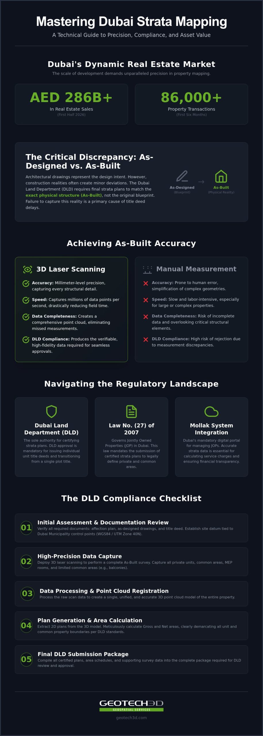
The Ultimate Strata Mapping Checklist for Dubai Developers
Successfully managing a Jointly Owned Property (JOP) declaration in 2026 requires more than just a basic survey. It demands a systematic approach to data acquisition and regulatory alignment. Developers who follow a structured workflow reduce the risk of DLD rejection and expedite the issuance of title deeds. This checklist outlines the essential phases of a professional real estate strata mapping project, ensuring every technical requirement is met before submission.
- Initial Site Assessment: Confirm the building has reached the necessary as-built stage and verify that all areas, including mechanical floors, are accessible for survey teams.
- Survey Methodology: Select between high-speed reality capture using tools like the Navvis VLX 3 or high-accuracy stationary scanning based on the architectural complexity.
- Data Acquisition: Capture every private unit, common area, and underground parking level to ensure a complete spatial record of the entire structure.
- Plan Drafting: Generate floor plans and area schedules that strictly adhere to DLD measurement standards for Gross and Net areas, ensuring no discrepancies exist.
- Submission & Certification: Facilitate the approval cycle through the DLD and ensure all survey data is correctly formatted for the Mollak portal.
Pre-Survey Readiness
Preparation is the most overlooked phase of the strata process. Before any equipment arrives on site, developers must consolidate all existing design drawings and necessary No Objection Certificates (NOCs). It’s critical to ensure survey teams have access to over-ceiling areas and MEP spaces. These technical zones often define the boundaries of common property and influence service charge allocations. Additionally, check for any structural changes made during the final stages of construction. If the physical site has deviated from the design, the survey must account for these changes to ensure the final real estate strata mapping is accurate.
Quality Assurance and DLD Compliance
The final output must undergo rigorous quality checks to meet 2026 standards. This includes verifying volumetric calculations for 3D strata titles, which are becoming more common in complex mixed-use developments. Every unit number must be cross-checked with the official building numbering system to prevent administrative errors during registration. Finally, ensure that all plans are digital-ready for integration into the Geoverse Platform. This enables city-scale asset management and provides a future-proof record for the Owners Association, supporting long-term transparency.
Leveraging GEOTECH 3D for High-Precision Strata Solutions
GEOTECH 3D operates as a primary partner for developers navigating the intricate regulatory landscape of Dubai. With decades of regional experience and full licensing for professional survey work in the UAE, the firm provides the technical security required for high-stakes projects. Establishing a reliable real estate strata mapping foundation is essential for long-term project viability. Our team manages the entire end-to-end workflow, transforming raw point cloud data into certified DLD-ready plans. This comprehensive service ensures that every unit boundary and common area is defined with the millimeter precision that modern Dubai developments demand.
Technical accuracy is only one part of the equation. GEOTECH 3D utilizes advanced hardware like the Faro S350 and Leica RTC 360 to deliver results within tight project schedules. We understand that delays in survey certification can stall unit handovers and impact cash flow. By deploying rapid indoor reality capture tools such as the Navvis VLX 3, we minimize site visit times while maximizing data density. Every project is executed under strict safety compliance protocols, ensuring that data acquisition occurs without disrupting ongoing construction or facility operations. This disciplined approach instills a sense of security for project managers who cannot afford discrepancies in their JOP declarations.
Beyond Compliance: The Geoverse Platform
While meeting DLD and Mollak requirements is critical, the value of high-precision mapping extends into the entire building lifecycle. The Geoverse Platform allows stakeholders to visualize strata data within a city-scale digital twin environment. This integration moves spatial data out of static PDF files and into a dynamic, interactive model. Developers and asset managers use this spatial analysis to optimize property management, track maintenance across complex MEP systems, and improve service charge transparency. It’s an aspirational step toward the future of smart city management in the UAE. You can explore these capabilities further in our Digital Twin for Asset Lifecycle guide, which details how reality capture supports long-term asset value.
Contact GEOTECH 3D in Dubai
Our team is based in Al Qusais, providing localized expertise to developers across the Emirates. If you’re preparing for a new project registration or need to resolve discrepancies in an existing development, we’re ready to assist. You can visit our Dubai office at Ilyaa Tower 2, Office 101, Damascus St., Al Qusais Industrial 3. For an immediate real estate strata mapping consultation, call our experts at +971 4 295 1589. Alternatively, you can email info@geotech3d.com to discuss your specific technical requirements or request a proposal for your next real estate project.
Securing the Future of Your Dubai Development
In 2026, the margin for error in the UAE property sector has effectively vanished. Shifting from manual measurements to high-fidelity reality capture is no longer optional; it’s a fundamental requirement for protecting your asset’s long-term value. By following the technical standards in this checklist, you ensure that every unit boundary and service charge allocation withstands the scrutiny of the Dubai Land Department and the Mollak portal. Precise real estate strata mapping provides the transparency that modern investors demand.
GEOTECH 3D offers the established expertise needed to navigate these technical complexities. Our team utilizes advanced Faro S350 and Leica RTC 360 scanning technology to deliver millimeter-accurate data. This precision integrates seamlessly from our 3D Scanning To BIM workflows into the Geoverse Platform, creating a digital foundation that empowers property managers for years to come. We’re here to guide you through every stage of the compliance journey with confidence and integrity.
We look forward to helping you achieve a seamless approval and a future-ready digital record for your next project.
Frequently Asked Questions
What is the difference between a standard floor plan and a strata plan in Dubai?
A standard floor plan is a general architectural layout, while a strata plan is a legal document that defines specific boundaries of individual ownership and common property. In Dubai, these plans are mandatory for the issuance of title deeds in multi-unit developments. They must adhere to strict Dubai Land Department standards for area measurement. Unlike a basic layout, a strata plan includes detailed area schedules that facilitate the legal subdivision of the property.
Is 3D laser scanning mandatory for strata mapping in the UAE?
3D laser scanning isn’t explicitly named as the only legal method, but the Dubai Land Department requires extreme as-built accuracy for all certifications. Traditional methods often fail to capture the complex geometries of modern UAE architecture. Using advanced hardware like the Faro S350 or Leica RTC 360 ensures that your real estate strata mapping meets the precision benchmarks required for immediate approval. It’s the most reliable way to avoid technical rejections.
How long does it take to get a strata plan certified by the Dubai Land Department?
The certification timeline for a strata plan depends on the project’s scale and the current DLD review cycle. Typically, once a certified surveyor submits the final as-built data, the review process takes several weeks. Ensuring that your data is digital-ready and compliant with all technical standards from the start is the best way to prevent delays. Professional firms often handle the end-to-end submission to expedite this approval process for developers.
Can strata mapping help in reducing service charge disputes?
Yes, accurate mapping is the most effective way to minimize service charge disputes. By providing a transparent breakdown of Net and Gross areas, developers can ensure that service charges are allocated fairly among unit owners. When the physical boundaries of common areas are clearly defined in a digital twin environment like the Geoverse Platform, there’s no room for ambiguity regarding maintenance responsibilities or financial contributions from individual owners.
What happens if my as-built measurements differ from my approved design drawings?
If your as-built measurements differ from the original design, the Dubai Land Department requires the strata plan to reflect the physical reality of the structure. Discrepancies are common in large-scale construction, but they must be documented by a licensed surveyor to ensure the JOP declaration remains valid. Failing to account for these changes can lead to significant delays in unit registration and the eventual issuance of individual title deeds.
How does the Mollak system use strata mapping data?
The Mollak system functions as the digital gateway for real estate governance in Dubai, utilizing strata mapping data to automate service charge invoices. It relies on the precise area calculations provided in the certified strata plan to determine each owner’s financial obligations. Without accurate spatial data, the system cannot generate the necessary approvals for owners’ associations to collect fees or manage building maintenance funds effectively across the development.
What is a JOP Declaration and why does it require accurate mapping?
A Jointly Owned Property (JOP) Declaration is a mandatory legal document that outlines the rules, rights, and obligations for a multi-unit development. It requires high-precision mapping because it serves as the definitive record for what constitutes private versus common property. In Dubai, this declaration is the basis for all future transactions and management activities. Accurate mapping ensures that the legal description of the property matches the physical building perfectly.
Do I need to re-map my building if I renovate or change unit configurations?
You must update your strata records if a renovation alters unit configurations or impacts common property boundaries. Any structural changes that modify the registered area of a unit require a new survey and submission to the DLD. This ensures that title deeds and the Mollak system reflect the current physical state of the building. Keeping your real estate strata mapping updated is essential for maintaining the legal integrity of the asset.

Did you know that Dubai’s real estate market processed over AED 286 billion in sales during the first half of 2026 alone? With 86,005 transactions recorded in just six months, the requirement for precision in real estate strata mapping has transitioned from a legal formality to a critical pillar of asset lifecycle management. You’ve likely experienced the frustration of title deed delays caused by minor discrepancies between as-built structures and original design drawings. These technical hurdles don’t just stall registrations; they complicate Mollak submissions and service charge allocations for years to come.
This article provides a professional technical checklist to help you master the complexities of strata title mapping and ensure full Dubai Land Department compliance. We’ll explore the latest 2026 regulatory standards, including Law No. (27) of 2007 requirements and the new digital mandates for jointly owned properties. By the end, you’ll have a roadmap for generating digital-ready strata records that facilitate seamless approvals and long-term asset value. Whether you’re managing a single tower or a master community, these insights ensure your spatial data meets the highest accuracy standards required in the current UAE market.
Key Takeaways
- Understand the critical role of the Dubai Land Department (DLD) in certifying strata plans to ensure legal ownership and smooth title deed issuance.
- Learn why it’s essential to distinguish between as-designed drawings and as-built reality to avoid discrepancies in area calculations.
- Discover how advanced 3D laser scanning technology streamlines real estate strata mapping by capturing high-precision data that manual measurements often miss.
- Access a comprehensive compliance checklist designed for Dubai developers to navigate initial site assessments and survey methodologies effectively.
- Explore how professional surveying partnerships help transform raw point cloud data into certified plans ready for Mollak registration and asset management.
The Evolution of Real Estate Strata Mapping in Dubai
Real estate strata mapping serves as the technical foundation for property rights in multi-unit developments across the UAE. This specialized process defines the boundaries between individual private units and the common property shared by all owners. In the past, basic 2D floor plans were often sufficient for registration. However, the complexity of modern Dubai architecture necessitates a more rigorous approach. The fundamental concept of a strata title permits the vertical subdivision of space, a necessity for the city’s iconic high-rises. Moving into 2026, the industry is transitioning toward BIM-integrated strata models. These digital twins provide a level of precision that ensures service charge transparency and eliminates the ambiguity that often led to disputes in earlier development phases.
The Dubai Land Department (DLD) acts as the ultimate authority for certifying these plans. Without an approved strata plan, a project cannot transition from a single plot title to individual unit titles. This certification process has become increasingly detailed. DLD surveyors now require data that reflects the exact physical reality of the building rather than just the initial design intent. This shift ensures that every square centimeter is accounted for, protecting the interests of developers, investors, and future owners alike.
Strata Law and Jointly Owned Property (JOP)
The legal framework for these developments is rooted in Law No. (27) of 2007, which governs Jointly Owned Properties in Dubai. This legislation mandates that developers provide certified strata plans before any title deeds can be issued. Precise mapping is a proactive measure that prevents future legal disputes between developers and owners’ associations. When the physical structure aligns perfectly with the registered plan, the risk of litigation over common area boundaries or unit sizes disappears. This alignment is critical for maintaining investor confidence in the UAE’s maturing market.
Mollak System Integration
Dubai’s Mollak system acts as the centralized hub for managing jointly owned properties, requiring high-fidelity strata data for every registration. The Mollak system serves as the mandatory digital gateway for real estate governance, ensuring that service charge transparency and financial accountability are maintained across all Dubai developments in 2026. Accurate real estate strata mapping data directly informs the calculation of service charges by establishing the exact entitlement of each unit owner. By integrating survey data into this portal, stakeholders gain a clear, auditable trail of area calculations. This digital synergy ensures that asset management remains data-driven and compliant with RERA guidelines.
Technical Standards for Strata Surveys and Floor Plans
Precision in real estate strata mapping depends on capturing the physical reality of a structure rather than its theoretical intent. While as-designed drawings reflect the architect’s original vision, the Dubai Land Department (DLD) mandates as-built accuracy for all final certifications. Discrepancies between design and reality often emerge during the construction phase. These variations, if left undocumented, lead to significant delays in unit registration and title deed issuance. A professional survey ensures that the digital record matches the physical asset exactly.
Dubai follows strict protocols for area measurement, distinguishing clearly between Gross and Net areas. This clarity is vital for transparent RICS Valuations in Dubai, as it ensures that investors understand exactly what they’re purchasing. Common areas such as lobbies, MEP rooms, and structural voids must be meticulously identified and excluded from private unit calculations. Conversely, limited common areas like balconies and private parking bays require specific notation in the Jointly Owned Property (JOP) declaration. This defines exclusive usage rights without granting full ownership of the structural elements.
Cadastral Mapping Requirements
Strata mapping is a localized subset of the UAE’s broader cadastral framework. All survey data must be tied to Dubai Municipality control points using the WGS84 / UTM Zone 40N coordinate system. Achieving this level of site datum accuracy is non-negotiable for successful DLD submission. Developers must provide a comprehensive documentation package, including the Common Areas Site Plan and the JOP Declaration, to facilitate the transition from a single plot title to individual units. High-precision data acquisition is the only way to meet these technical benchmarks consistently.
Defining Unit Boundaries
Determining where a unit ends and common property begins is a complex technical challenge. In Dubai, most strata plans utilize the internal face of the wall for unit area calculations, ensuring that owners aren’t charged for structural or shared partitions. Capturing these boundaries in modern architecture with curved facades or complex geometries requires advanced spatial data tools. Ensuring every square centimeter is accounted for prevents future disputes over service charge allocations. If you’re looking for precision, you can explore specialized real estate strata solutions to ensure your JOP declaration is technically flawless.
3D Laser Scanning vs. Manual Measurement for Strata Accuracy
Traditional manual measurement relies on tape measures and handheld DISTO devices. While these tools are common, they’re fundamentally limited when applied to complex Dubai high-rises. Manual methods often miss structural deviations, slab thickness variations, or subtle wall leans. These inaccuracies ripple through the real estate strata mapping process, leading to miscalculated unit areas and potential disputes. 3D laser scanning eliminates this risk by capturing the true as-built condition with millimeter precision. It creates a comprehensive spatial dataset that serves as a permanent digital record for future maintenance and renovations.
Reality Capture with Navvis VLX 3 and Leica RTC 360
Mobile mapping with the Navvis VLX 3 enables surveyors to map thousands of square meters in hours rather than days. For stationary, ultra-high-resolution needs, hardware like the Leica RTC 360 or Faro S350 provides unmatched detail. These tools capture millions of data points to create a point cloud, ensuring that no architectural detail is overlooked. One significant advantage is the Bubble view feature. This allows developers and auditors to conduct remote site inspections through high-resolution panoramic imagery linked to the spatial data. It’s a reliable way to verify site conditions without repeated visits. From this point cloud, surveyors extract high-precision 2D floor plans that meet the most stringent regulatory requirements.
Scan-to-BIM for Strata Management
The evolution of real estate strata mapping is moving toward a 3D-first approach. By integrating strata boundaries directly into a Building Information Model, stakeholders can visualize the relationship between private units and common MEP infrastructure. This is particularly useful for long-term asset lifecycle management. A BIM-ready model allows facility managers to track maintenance schedules and structural changes within the context of legal ownership boundaries. You can learn more about this in our guide to BIM Modeling from Laser Scans. This integration ensures that the strata data remains a functional asset throughout the building’s life rather than just a static compliance document.
The Ultimate Strata Mapping Checklist for Dubai Developers
Successfully managing a Jointly Owned Property (JOP) declaration in 2026 requires more than just a basic survey. It demands a systematic approach to data acquisition and regulatory alignment. Developers who follow a structured workflow reduce the risk of DLD rejection and expedite the issuance of title deeds. This checklist outlines the essential phases of a professional real estate strata mapping project, ensuring every technical requirement is met before submission.
- Initial Site Assessment: Confirm the building has reached the necessary as-built stage and verify that all areas, including mechanical floors, are accessible for survey teams.
- Survey Methodology: Select between high-speed reality capture using tools like the Navvis VLX 3 or high-accuracy stationary scanning based on the architectural complexity.
- Data Acquisition: Capture every private unit, common area, and underground parking level to ensure a complete spatial record of the entire structure.
- Plan Drafting: Generate floor plans and area schedules that strictly adhere to DLD measurement standards for Gross and Net areas, ensuring no discrepancies exist.
- Submission & Certification: Facilitate the approval cycle through the DLD and ensure all survey data is correctly formatted for the Mollak portal.
Pre-Survey Readiness
Preparation is the most overlooked phase of the strata process. Before any equipment arrives on site, developers must consolidate all existing design drawings and necessary No Objection Certificates (NOCs). It’s critical to ensure survey teams have access to over-ceiling areas and MEP spaces. These technical zones often define the boundaries of common property and influence service charge allocations. Additionally, check for any structural changes made during the final stages of construction. If the physical site has deviated from the design, the survey must account for these changes to ensure the final real estate strata mapping is accurate.
Quality Assurance and DLD Compliance
The final output must undergo rigorous quality checks to meet 2026 standards. This includes verifying volumetric calculations for 3D strata titles, which are becoming more common in complex mixed-use developments. Every unit number must be cross-checked with the official building numbering system to prevent administrative errors during registration. Finally, ensure that all plans are digital-ready for integration into the Geoverse Platform. This enables city-scale asset management and provides a future-proof record for the Owners Association, supporting long-term transparency.
Leveraging GEOTECH 3D for High-Precision Strata Solutions
GEOTECH 3D operates as a primary partner for developers navigating the intricate regulatory landscape of Dubai. With decades of regional experience and full licensing for professional survey work in the UAE, the firm provides the technical security required for high-stakes projects. Establishing a reliable real estate strata mapping foundation is essential for long-term project viability. Our team manages the entire end-to-end workflow, transforming raw point cloud data into certified DLD-ready plans. This comprehensive service ensures that every unit boundary and common area is defined with the millimeter precision that modern Dubai developments demand.
Technical accuracy is only one part of the equation. GEOTECH 3D utilizes advanced hardware like the Faro S350 and Leica RTC 360 to deliver results within tight project schedules. We understand that delays in survey certification can stall unit handovers and impact cash flow. By deploying rapid indoor reality capture tools such as the Navvis VLX 3, we minimize site visit times while maximizing data density. Every project is executed under strict safety compliance protocols, ensuring that data acquisition occurs without disrupting ongoing construction or facility operations. This disciplined approach instills a sense of security for project managers who cannot afford discrepancies in their JOP declarations.
Beyond Compliance: The Geoverse Platform
While meeting DLD and Mollak requirements is critical, the value of high-precision mapping extends into the entire building lifecycle. The Geoverse Platform allows stakeholders to visualize strata data within a city-scale digital twin environment. This integration moves spatial data out of static PDF files and into a dynamic, interactive model. Developers and asset managers use this spatial analysis to optimize property management, track maintenance across complex MEP systems, and improve service charge transparency. It’s an aspirational step toward the future of smart city management in the UAE. You can explore these capabilities further in our Digital Twin for Asset Lifecycle guide, which details how reality capture supports long-term asset value.
Contact GEOTECH 3D in Dubai
Our team is based in Al Qusais, providing localized expertise to developers across the Emirates. If you’re preparing for a new project registration or need to resolve discrepancies in an existing development, we’re ready to assist. You can visit our Dubai office at Ilyaa Tower 2, Office 101, Damascus St., Al Qusais Industrial 3. For an immediate real estate strata mapping consultation, call our experts at +971 4 295 1589. Alternatively, you can email info@geotech3d.com to discuss your specific technical requirements or request a proposal for your next real estate project.
Securing the Future of Your Dubai Development
In 2026, the margin for error in the UAE property sector has effectively vanished. Shifting from manual measurements to high-fidelity reality capture is no longer optional; it’s a fundamental requirement for protecting your asset’s long-term value. By following the technical standards in this checklist, you ensure that every unit boundary and service charge allocation withstands the scrutiny of the Dubai Land Department and the Mollak portal. Precise real estate strata mapping provides the transparency that modern investors demand.
GEOTECH 3D offers the established expertise needed to navigate these technical complexities. Our team utilizes advanced Faro S350 and Leica RTC 360 scanning technology to deliver millimeter-accurate data. This precision integrates seamlessly from our 3D Scanning To BIM workflows into the Geoverse Platform, creating a digital foundation that empowers property managers for years to come. We’re here to guide you through every stage of the compliance journey with confidence and integrity.
We look forward to helping you achieve a seamless approval and a future-ready digital record for your next project.
Frequently Asked Questions
What is the difference between a standard floor plan and a strata plan in Dubai?
A standard floor plan is a general architectural layout, while a strata plan is a legal document that defines specific boundaries of individual ownership and common property. In Dubai, these plans are mandatory for the issuance of title deeds in multi-unit developments. They must adhere to strict Dubai Land Department standards for area measurement. Unlike a basic layout, a strata plan includes detailed area schedules that facilitate the legal subdivision of the property.
Is 3D laser scanning mandatory for strata mapping in the UAE?
3D laser scanning isn’t explicitly named as the only legal method, but the Dubai Land Department requires extreme as-built accuracy for all certifications. Traditional methods often fail to capture the complex geometries of modern UAE architecture. Using advanced hardware like the Faro S350 or Leica RTC 360 ensures that your real estate strata mapping meets the precision benchmarks required for immediate approval. It’s the most reliable way to avoid technical rejections.
How long does it take to get a strata plan certified by the Dubai Land Department?
The certification timeline for a strata plan depends on the project’s scale and the current DLD review cycle. Typically, once a certified surveyor submits the final as-built data, the review process takes several weeks. Ensuring that your data is digital-ready and compliant with all technical standards from the start is the best way to prevent delays. Professional firms often handle the end-to-end submission to expedite this approval process for developers.
Can strata mapping help in reducing service charge disputes?
Yes, accurate mapping is the most effective way to minimize service charge disputes. By providing a transparent breakdown of Net and Gross areas, developers can ensure that service charges are allocated fairly among unit owners. When the physical boundaries of common areas are clearly defined in a digital twin environment like the Geoverse Platform, there’s no room for ambiguity regarding maintenance responsibilities or financial contributions from individual owners.
What happens if my as-built measurements differ from my approved design drawings?
If your as-built measurements differ from the original design, the Dubai Land Department requires the strata plan to reflect the physical reality of the structure. Discrepancies are common in large-scale construction, but they must be documented by a licensed surveyor to ensure the JOP declaration remains valid. Failing to account for these changes can lead to significant delays in unit registration and the eventual issuance of individual title deeds.
How does the Mollak system use strata mapping data?
The Mollak system functions as the digital gateway for real estate governance in Dubai, utilizing strata mapping data to automate service charge invoices. It relies on the precise area calculations provided in the certified strata plan to determine each owner’s financial obligations. Without accurate spatial data, the system cannot generate the necessary approvals for owners’ associations to collect fees or manage building maintenance funds effectively across the development.
What is a JOP Declaration and why does it require accurate mapping?
A Jointly Owned Property (JOP) Declaration is a mandatory legal document that outlines the rules, rights, and obligations for a multi-unit development. It requires high-precision mapping because it serves as the definitive record for what constitutes private versus common property. In Dubai, this declaration is the basis for all future transactions and management activities. Accurate mapping ensures that the legal description of the property matches the physical building perfectly.
Do I need to re-map my building if I renovate or change unit configurations?
You must update your strata records if a renovation alters unit configurations or impacts common property boundaries. Any structural changes that modify the registered area of a unit require a new survey and submission to the DLD. This ensures that title deeds and the Mollak system reflect the current physical state of the building. Keeping your real estate strata mapping updated is essential for maintaining the legal integrity of the asset.
Search Now
Error: Contact form not found.