

Our Services
How to Implement Drone Based Site Inspections: A Professional 2026 Guide
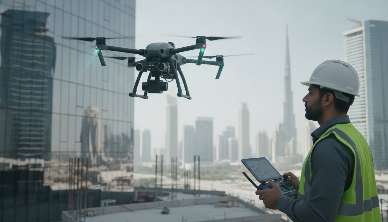
In 2026, relying on manual inspections for high-rise facades or flare-sticks isn’t just a safety risk, it’s a strategic bottleneck that delays critical project milestones across Dubai. Industry leaders recognize that traditional surveying methods often struggle to provide the millimetre-accurate data required for modern BIM and Digital Twin integration, making professional drone based site inspections the essential foundation for sophisticated asset management. The inconsistent quality and slow turnaround times of manual data acquisition can stall even the most robust construction schedules.
This guide will show you how to leverage advanced UAV technology, specifically DJI Zenmuse H20T multi-sensor payloads, to transform your workflows into a seamless, data-driven experience. You’ll learn how to navigate the complex UAE regulatory landscape while ensuring higher precision and safety. We’ll explore the transition from raw point clouds to BIM-ready models via the GEOVERSE platform, providing a roadmap for reduced operational costs and enhanced decision-making.
Key Takeaways
- Understand the transition from traditional visual monitoring to high-precision geospatial analysis using advanced multi-sensor UAV technology.
- Navigate the strict UAE regulatory environment by securing the necessary GCAA and DCAA permits required for all 2026 commercial operations.
- Discover how to execute professional drone based site inspections using specialized payloads like the DJI Zenmuse H20T for millimetre-accurate results.
- Learn the technical workflow for converting raw aerial point clouds into BIM-ready models and fully integrated Digital Twins.
- Leverage the GEOVERSE platform to centralize your inspection data, enabling faster decision-making and significantly reduced operational downtime.
What are Drone Based Site Inspections and Why Are They Essential in 2026?
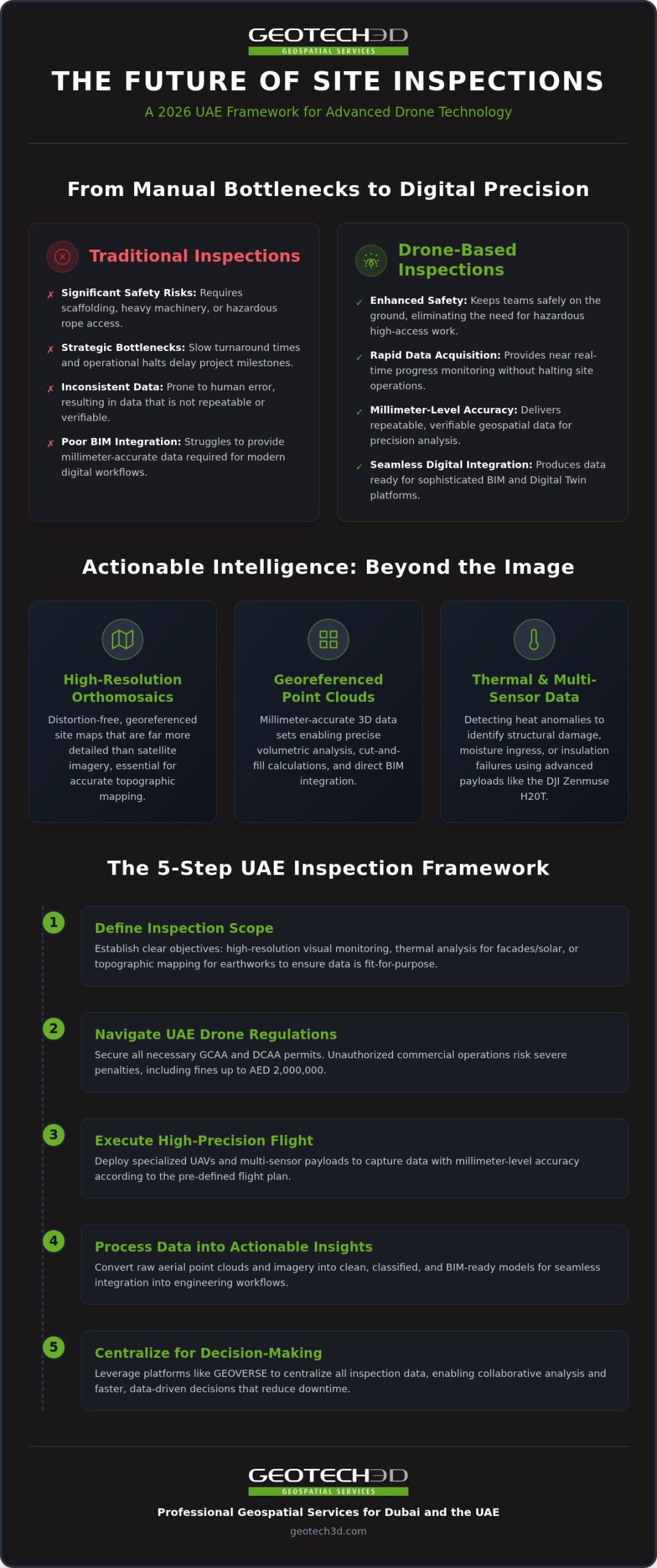
Drone based site inspections involve the systematic use of an unmanned aerial vehicle (UAV) to capture high-precision geospatial and visual data from an aerial perspective. By 2026, the industry’s focus has shifted significantly. We’re no longer just taking photos; we’re performing multi-sensor geospatial analysis that informs every stage of the project lifecycle. This evolution allows developers and engineers to maintain a granular level of oversight that was previously impossible without significant manual labor.
In the high-density urban landscape of Dubai, the primary benefits of this technology are safety, speed, and cost-efficiency. Drones provide a non-intrusive method for gathering data without halting site operations or endangering personnel. They don’t replace traditional 3D laser scanning; instead, they complement it. While ground-based scanners provide extreme detail at eye level or indoors, drones capture the “top-down” data needed for a truly comprehensive site model. This synergy ensures that no part of a structure remains unmapped.
The Advantage Over Traditional Inspection Methods
Traditional inspections often require scaffolding, heavy machinery, or rope access, which are both time-consuming and hazardous. Drones eliminate these requirements for facade and high-rise monitoring, keeping your team safely on the ground. Instead of waiting for static monthly reports, you get real-time progress monitoring. This immediacy helps you spot deviations from the design before they become structural issues. For large-scale UAE infrastructure, automated data collection reduces the human error often found in manual surveying, ensuring that every measurement is repeatable and verifiable.
Key Data Outputs: More Than Just Images
Modern drone based site inspections produce actionable intelligence through various specialized outputs that integrate directly into engineering workflows. These outputs include:
- High-resolution orthomosaics: These are essential for topographic mapping, providing a clear, distortion-free map of the entire site that is far more detailed than satellite imagery.
- Georeferenced point clouds: These 3D data sets allow for millimetre-accurate volumetric analysis of stockpiles and seamless integration into BIM environments.
- Thermal data: Using advanced sensors like the DJI Zenmuse H20T, we can detect heat anomalies that reveal internal structural damages, moisture ingress, or insulation failures in solar installations and facades.
This data integration is particularly vital for the development of Digital Twins. By feeding aerial data into a centralized platform, stakeholders can visualize the project’s as-built status against the as-designed model. It’s a level of transparency that secures project timelines and ensures long-term asset integrity.
How to Plan Your Drone Inspection: A Step-by-Step UAE Framework
Successful drone based site inspections begin long before the rotors spin. In the UAE, planning is a multi-layered process that bridges technical requirements with a rigorous legal framework. First, you must define the inspection scope. Are you looking for high-resolution visual data for facade monitoring, thermal analysis for solar arrays, or topographic mapping for earthworks? Each objective dictates the sensors used and the flight parameters required. Establishing these goals early ensures that the data collected is fit for purpose and ready for integration into your BIM environment.
Navigating UAE Drone Regulations
In 2026, the regulatory environment in the UAE is complex and requires careful navigation. While commercial operations are vital for the construction sector, the legal landscape has seen significant volatility. Following the GCAA safety decision in March 2026, which initially signaled a nationwide suspension of drone flights due to security concerns, the path to compliance requires constant vigilance. It’s absolutely necessary for any business to contact the GCAA and DCAA directly for the most current guidance before planning a project. Unauthorized commercial activities can lead to severe penalties, including fines of up to AED 2,000,000. Similar to the findings in this Department of Energy drone inspection case study, structured planning and regulatory alignment are the primary drivers of safety and cost savings in high-stakes environments. Commercial permits in Dubai typically involve specific costs, such as AED 1,500 for a DCAA no-objection certificate, and require mandatory third-party liability insurance of at least AED 5 million.
Technical Site Preparation
To achieve centimetre-level accuracy, technical preparation is mandatory. We establish Ground Control Points (GCPs) across the site, which act as physical anchors for the digital data. For high-precision topographic mapping, we utilize base stations for Real-Time Kinematic (RTK) positioning. This setup allows the drone to maintain its exact location relative to the ground, even in the dense urban corridors of Dubai. Scheduling is equally important; we often time flights to optimize lighting for facade inspections or to minimize disruption during peak site activity. Coordination with site management is vital for specialized tasks like confined space or shaft inspections, where signal interference and safety protocols require meticulous planning. If you’re unsure about the specific requirements for your project, consulting with a specialized drone services provider can help streamline the approval process.
Risk assessment is the final, critical step. On active construction sites, we develop safety protocols that account for crane movements, personnel locations, and weather conditions. These protocols don’t just ensure compliance; they protect your assets and maintain the integrity of the data collection process.
Executing the Inspection: Sensors and Payloads
The effectiveness of drone based site inspections depends entirely on the precision of the payload. By 2026, the industry has moved beyond single-purpose cameras to integrated multi-sensor systems like the DJI Zenmuse H20T. This payload is the gold standard for complex industrial environments in Dubai, combining a wide camera, a 23x optical zoom camera, a laser rangefinder, and a radiometric thermal sensor. It allows our teams to capture multiple layers of data in a single flight, providing a comprehensive view of asset health without the need for repeated deployments.
Choosing the right technology for your terrain is a strategic decision. While photogrammetry is excellent for creating high-resolution visual orthomosaics and 3D models of urban facades, LiDAR offers distinct advantages for complex structural lattice work or areas with dense vegetation. LiDAR generates georeferenced point clouds by firing laser pulses, providing superior accuracy in environments where visual sensors might struggle. For large-scale civil engineering projects across the UAE, selecting the appropriate sensor ensures that the final data is both actionable and millimetre-accurate.
High-Resolution and Thermal Sensing
Thermal sensors are now indispensable for identifying anomalies that remain invisible to the naked eye. In the intense UAE climate, solar panel efficiency is a priority; thermal imaging quickly identifies defective cells or hot spots that indicate internal damage or moisture ingress. For the Oil & Gas sector, the high-resolution zoom on the H20T allows for detailed monitoring of flare-sticks and pipelines from a safe distance. This capability identifies corrosion or structural fatigue without the need for costly operational shutdowns or high-risk manual climbing.
Confined Space and Specialized Surveys
UAV technology also extends into challenging environments where traditional GPS signals often fail. We execute specialized inspections in shafts, over-ceiling areas, and even within Marine & Naval construction projects in Dubai’s busy ports. Using drones for these tasks removes ground personnel from hazardous zones, which is a significant safety benefit. By deploying specialized sensors in confined spaces, we provide a level of detail that manual inspections simply can’t match. This ensures that every weld and joint is accounted for in the digital record, supporting long-term asset integrity and compliance with strict safety requirements.
By leveraging these advanced payloads, we provide a degree of oversight that transforms raw data into a strategic asset. Whether it’s a routine facade check or a complex pipeline survey, the right sensor configuration is the foundation of a successful inspection workflow.
Processing Data into Actionable Insights and Digital Twins
Data capture is only the beginning. The true value of professional drone based site inspections lies in the post-processing phase. Raw point clouds, while visually impressive, require sophisticated processing to become actionable engineering assets. We ensure full data compatibility with major client CAD packages, allowing seamless integration into existing design environments. This transformation converts millions of discrete data points into structured, intelligent models that drive project efficiency and reduce manual data entry errors.
Volumetric analysis is a primary application for our construction and mining clients across the UAE. By comparing sequential aerial surveys, we provide precise calculations of stockpile volumes and excavation progress. This level of oversight reduces the risk of cost overruns. It ensures that earthworks align perfectly with the project schedule. These calculations are repeatable and verifiable, providing a level of transparency that traditional surveying methods can’t match.
The Path to Scan-to-BIM Integration
Aligning aerial data with BIM modeling from laser scans creates a unified as-built record of the entire site. This process is essential for heritage preservation projects in older districts of Dubai, where accurate 3D documentation protects historical integrity. Automating progress monitoring through these models provides a transparent view of the site. It allows project managers to identify bottlenecks before they impact the bottom line. The result is a high-fidelity model that serves as a single source of truth for all stakeholders.
Utilizing the GEOVERSE Platform
The GEOVERSE platform serves as the central nervous system for large-scale infrastructure projects. It enables city-scale modeling and supports Dubai’s smart city management initiatives through real-time spatial analysis. By linking a digital twin for asset lifecycle to live drone data, asset owners can monitor structural health and operational performance from a single interface. This integration ensures that the data collected during drone based site inspections continues to provide value long after the construction phase is complete. It transforms a static inspection into a dynamic management tool.
Implementing Drone Inspections with GEOTECH 3D
GEOTECH 3D brings decades of specialized team experience to the Middle Eastern geospatial sector, acting as a faithful guide through evolving technical and regulatory requirements. We provide comprehensive, end-to-end solutions that bridge the gap between initial flight planning and final BIM delivery. In 2026, our professional registration and licensing across the UAE ensure that your project meets every GCAA and DCAA requirement without administrative delay. We don’t just capture data; we deliver a partnership rooted in precision and long-term commitment. This results-oriented approach ensures that drone based site inspections become a seamless part of your existing project management workflow, providing security in the face of complex technical demands.
Expertise in Oil & Gas and Infrastructure
We specialize in high-stakes environments such as Oil & Gas facilities, power plants, and complex brownfields. Our teams execute specialized surveys for pipelines where strict adherence to safety and time constraints is non-negotiable. By integrating LiDAR with drone technology, we produce accurate 3D models of facilities that serve as reliable as-built documentation for asset owners. This expertise extends to Dubai’s architectural landmarks, where structural survey excellence is required to maintain the integrity of world-class designs. We utilize advanced sensors like the DJI Zenmuse H20T to ensure that every flare-stick or high-altitude component is inspected with millimetre-level detail, effectively removing the need for high-risk manual climbing or expensive scaffolding.
Why Partner with a Local Specialist?
Choosing a local specialist offers distinct advantages in the UAE’s unique environmental and regulatory conditions. We provide fast response times and local technical support that international providers simply can’t match. Our deep understanding of the Subsurface Utility Engineering Dubai context allows us to integrate aerial data with underground mapping for a truly holistic site view. Reliability in harsh desert environments is a core part of our service. We ensure that your drone based site inspections are conducted with the highest degree of accuracy, even when dealing with high temperatures, dust, or shifting sands. This local expertise ensures that every survey is compliant, safe, and tailored to the specific needs of the Dubai market, moving the dialogue beyond a simple service provider relationship toward a collaborative alliance.
Advancing Your Infrastructure Strategy with Aerial Intelligence
Professional drone based site inspections have evolved into a critical component of successful civil engineering in the UAE. By 2026, the industry’s focus has shifted from simple visual monitoring to a sophisticated data ecosystem that prioritizes safety and precision. Utilizing cutting-edge technology like the DJI Zenmuse H20T allows for the capture of complex structural data that was previously inaccessible. This information doesn’t just sit in a folder; it integrates directly into the GEOVERSE Digital Twin platform to drive long-term asset management.
Partnering with a professionally registered and licensed team ensures that your project remains compliant with all GCAA and DCAA regulations. This collaborative approach turns raw aerial data into millimetre-accurate BIM models, reducing operational downtime and preventing costly site errors. It’s a strategic investment in the reliability and longevity of your infrastructure, providing the high-fidelity insights needed to make informed, data-driven decisions.
We’re ready to help you transform your site inspection workflows and embrace the future of geospatial technology in Dubai. Let’s build a safer and more efficient future together.
Frequently Asked Questions
Are drone based site inspections legal in Dubai?
Commercial drone based site inspections are legal in Dubai when conducted by professionally registered and licensed operators like GEOTECH 3D. You must obtain specific permits from the General Civil Aviation Authority (GCAA) and the Dubai Civil Aviation Authority (DCAA) for every mission. These regulations are strictly enforced to ensure national airspace security. We manage these complex permit processes to ensure every flight complies with the latest 2026 safety decisions and UAE aviation laws.
How accurate is drone-based surveying compared to traditional methods?
Drone-based surveying provides centimetre-level accuracy that rivals traditional ground-based methods for large-scale sites. By using Real-Time Kinematic (RTK) positioning and Ground Control Points (GCPs), we achieve high-precision data suitable for topographic mapping and volumetric analysis. While 3D laser scanning remains the standard for millimetre-accurate indoor details, drones offer a comprehensive aerial perspective that captures site-wide data much faster than manual surveying teams can achieve on the ground.
What kind of sensors do you use for flare-stick inspections?
For flare-stick inspections, we utilize the DJI Zenmuse H20T multi-sensor payload. This advanced equipment features a high-resolution 23x optical zoom camera and a radiometric thermal sensor. The zoom allows our team to inspect structural integrity from a safe distance, while the thermal sensor identifies heat anomalies or internal damages. This combination ensures thorough monitoring of Oil & Gas assets without requiring costly facility shutdowns or high-risk manual climbing by personnel.
Can drones perform inspections in confined spaces or indoors?
Yes, specialized UAVs are designed to perform inspections in confined spaces, shafts, and over-ceiling areas. These drones operate without GPS by using advanced collision-avoidance sensors and internal lighting systems. This technology is particularly valuable for Marine & Naval construction or inspecting large industrial boiler interiors. By removing ground personnel from these hazardous zones, we significantly improve site safety while capturing high-resolution data in hard-to-reach locations across your facility.
How long does it take to process drone data into a BIM model?
Processing timelines vary based on the project’s scale and the required level of detail. Typically, raw point cloud data can be processed into a preliminary 3D model within a few days. Converting this into a fully structured, BIM-ready model for complex civil projects may take longer. We focus on delivering high-quality documentation that integrates seamlessly with your existing CAD packages, ensuring the final output is actionable for your engineering and management teams.
What are the safety requirements for drone operations on a construction site?
Safety on an active construction site requires a rigorous risk assessment that accounts for crane movements, weather conditions, and personnel locations. All operators must hold valid GCAA and DCAA licenses and maintain third-party liability insurance with a minimum coverage of AED 5 million in Dubai. We establish strict flight boundaries and maintain constant communication with site management to ensure that drone based site inspections never compromise the safety of your ground operations.
Do I need to clear my site before a drone inspection takes place?
You don’t usually need to clear the entire site, but coordination is essential for the best results. While drones can capture data over active sites, minimizing heavy vehicle movement during the flight can improve the clarity of orthomosaics and point clouds. We schedule our operations to align with your site’s workflow, often flying during periods of lower activity to ensure maximum data quality without causing any unnecessary operational delays for your project.
How does the GEOVERSE platform help with asset management?
The GEOVERSE platform centralizes all geospatial data into a unified Digital Twin. This allows asset owners to visualize structural health, monitor construction progress, and perform spatial analysis from a single interface. By integrating drone data with ground-based scans, GEOVERSE supports smart city management and long-term asset lifecycle planning. It transforms static inspection reports into a dynamic, living model that helps you make informed decisions about maintenance and future resource allocation.
In 2026, relying on manual inspections for high-rise facades or flare-sticks isn’t just a safety risk, it’s a strategic bottleneck that delays critical project milestones across Dubai. Industry leaders recognize that traditional surveying methods often struggle to provide the millimetre-accurate data required for modern BIM and Digital Twin integration, making professional drone based site inspections the essential foundation for sophisticated asset management. The inconsistent quality and slow turnaround times of manual data acquisition can stall even the most robust construction schedules.
This guide will show you how to leverage advanced UAV technology, specifically DJI Zenmuse H20T multi-sensor payloads, to transform your workflows into a seamless, data-driven experience. You’ll learn how to navigate the complex UAE regulatory landscape while ensuring higher precision and safety. We’ll explore the transition from raw point clouds to BIM-ready models via the GEOVERSE platform, providing a roadmap for reduced operational costs and enhanced decision-making.
Key Takeaways
- Understand the transition from traditional visual monitoring to high-precision geospatial analysis using advanced multi-sensor UAV technology.
- Navigate the strict UAE regulatory environment by securing the necessary GCAA and DCAA permits required for all 2026 commercial operations.
- Discover how to execute professional drone based site inspections using specialized payloads like the DJI Zenmuse H20T for millimetre-accurate results.
- Learn the technical workflow for converting raw aerial point clouds into BIM-ready models and fully integrated Digital Twins.
- Leverage the GEOVERSE platform to centralize your inspection data, enabling faster decision-making and significantly reduced operational downtime.
What are Drone Based Site Inspections and Why Are They Essential in 2026?
Drone based site inspections involve the systematic use of an unmanned aerial vehicle (UAV) to capture high-precision geospatial and visual data from an aerial perspective. By 2026, the industry’s focus has shifted significantly. We’re no longer just taking photos; we’re performing multi-sensor geospatial analysis that informs every stage of the project lifecycle. This evolution allows developers and engineers to maintain a granular level of oversight that was previously impossible without significant manual labor.
In the high-density urban landscape of Dubai, the primary benefits of this technology are safety, speed, and cost-efficiency. Drones provide a non-intrusive method for gathering data without halting site operations or endangering personnel. They don’t replace traditional 3D laser scanning; instead, they complement it. While ground-based scanners provide extreme detail at eye level or indoors, drones capture the “top-down” data needed for a truly comprehensive site model. This synergy ensures that no part of a structure remains unmapped.
The Advantage Over Traditional Inspection Methods
Traditional inspections often require scaffolding, heavy machinery, or rope access, which are both time-consuming and hazardous. Drones eliminate these requirements for facade and high-rise monitoring, keeping your team safely on the ground. Instead of waiting for static monthly reports, you get real-time progress monitoring. This immediacy helps you spot deviations from the design before they become structural issues. For large-scale UAE infrastructure, automated data collection reduces the human error often found in manual surveying, ensuring that every measurement is repeatable and verifiable.
Key Data Outputs: More Than Just Images
Modern drone based site inspections produce actionable intelligence through various specialized outputs that integrate directly into engineering workflows. These outputs include:
- High-resolution orthomosaics: These are essential for topographic mapping, providing a clear, distortion-free map of the entire site that is far more detailed than satellite imagery.
- Georeferenced point clouds: These 3D data sets allow for millimetre-accurate volumetric analysis of stockpiles and seamless integration into BIM environments.
- Thermal data: Using advanced sensors like the DJI Zenmuse H20T, we can detect heat anomalies that reveal internal structural damages, moisture ingress, or insulation failures in solar installations and facades.
This data integration is particularly vital for the development of Digital Twins. By feeding aerial data into a centralized platform, stakeholders can visualize the project’s as-built status against the as-designed model. It’s a level of transparency that secures project timelines and ensures long-term asset integrity.
How to Plan Your Drone Inspection: A Step-by-Step UAE Framework
Successful drone based site inspections begin long before the rotors spin. In the UAE, planning is a multi-layered process that bridges technical requirements with a rigorous legal framework. First, you must define the inspection scope. Are you looking for high-resolution visual data for facade monitoring, thermal analysis for solar arrays, or topographic mapping for earthworks? Each objective dictates the sensors used and the flight parameters required. Establishing these goals early ensures that the data collected is fit for purpose and ready for integration into your BIM environment.
Navigating UAE Drone Regulations
In 2026, the regulatory environment in the UAE is complex and requires careful navigation. While commercial operations are vital for the construction sector, the legal landscape has seen significant volatility. Following the GCAA safety decision in March 2026, which initially signaled a nationwide suspension of drone flights due to security concerns, the path to compliance requires constant vigilance. It’s absolutely necessary for any business to contact the GCAA and DCAA directly for the most current guidance before planning a project. Unauthorized commercial activities can lead to severe penalties, including fines of up to AED 2,000,000. Similar to the findings in this Department of Energy drone inspection case study, structured planning and regulatory alignment are the primary drivers of safety and cost savings in high-stakes environments. Commercial permits in Dubai typically involve specific costs, such as AED 1,500 for a DCAA no-objection certificate, and require mandatory third-party liability insurance of at least AED 5 million.
Technical Site Preparation
To achieve centimetre-level accuracy, technical preparation is mandatory. We establish Ground Control Points (GCPs) across the site, which act as physical anchors for the digital data. For high-precision topographic mapping, we utilize base stations for Real-Time Kinematic (RTK) positioning. This setup allows the drone to maintain its exact location relative to the ground, even in the dense urban corridors of Dubai. Scheduling is equally important; we often time flights to optimize lighting for facade inspections or to minimize disruption during peak site activity. Coordination with site management is vital for specialized tasks like confined space or shaft inspections, where signal interference and safety protocols require meticulous planning. If you’re unsure about the specific requirements for your project, consulting with a specialized drone services provider can help streamline the approval process.
Risk assessment is the final, critical step. On active construction sites, we develop safety protocols that account for crane movements, personnel locations, and weather conditions. These protocols don’t just ensure compliance; they protect your assets and maintain the integrity of the data collection process.
Executing the Inspection: Sensors and Payloads
The effectiveness of drone based site inspections depends entirely on the precision of the payload. By 2026, the industry has moved beyond single-purpose cameras to integrated multi-sensor systems like the DJI Zenmuse H20T. This payload is the gold standard for complex industrial environments in Dubai, combining a wide camera, a 23x optical zoom camera, a laser rangefinder, and a radiometric thermal sensor. It allows our teams to capture multiple layers of data in a single flight, providing a comprehensive view of asset health without the need for repeated deployments.
Choosing the right technology for your terrain is a strategic decision. While photogrammetry is excellent for creating high-resolution visual orthomosaics and 3D models of urban facades, LiDAR offers distinct advantages for complex structural lattice work or areas with dense vegetation. LiDAR generates georeferenced point clouds by firing laser pulses, providing superior accuracy in environments where visual sensors might struggle. For large-scale civil engineering projects across the UAE, selecting the appropriate sensor ensures that the final data is both actionable and millimetre-accurate.
High-Resolution and Thermal Sensing
Thermal sensors are now indispensable for identifying anomalies that remain invisible to the naked eye. In the intense UAE climate, solar panel efficiency is a priority; thermal imaging quickly identifies defective cells or hot spots that indicate internal damage or moisture ingress. For the Oil & Gas sector, the high-resolution zoom on the H20T allows for detailed monitoring of flare-sticks and pipelines from a safe distance. This capability identifies corrosion or structural fatigue without the need for costly operational shutdowns or high-risk manual climbing.
Confined Space and Specialized Surveys
UAV technology also extends into challenging environments where traditional GPS signals often fail. We execute specialized inspections in shafts, over-ceiling areas, and even within Marine & Naval construction projects in Dubai’s busy ports. Using drones for these tasks removes ground personnel from hazardous zones, which is a significant safety benefit. By deploying specialized sensors in confined spaces, we provide a level of detail that manual inspections simply can’t match. This ensures that every weld and joint is accounted for in the digital record, supporting long-term asset integrity and compliance with strict safety requirements.
By leveraging these advanced payloads, we provide a degree of oversight that transforms raw data into a strategic asset. Whether it’s a routine facade check or a complex pipeline survey, the right sensor configuration is the foundation of a successful inspection workflow.
Processing Data into Actionable Insights and Digital Twins
Data capture is only the beginning. The true value of professional drone based site inspections lies in the post-processing phase. Raw point clouds, while visually impressive, require sophisticated processing to become actionable engineering assets. We ensure full data compatibility with major client CAD packages, allowing seamless integration into existing design environments. This transformation converts millions of discrete data points into structured, intelligent models that drive project efficiency and reduce manual data entry errors.
Volumetric analysis is a primary application for our construction and mining clients across the UAE. By comparing sequential aerial surveys, we provide precise calculations of stockpile volumes and excavation progress. This level of oversight reduces the risk of cost overruns. It ensures that earthworks align perfectly with the project schedule. These calculations are repeatable and verifiable, providing a level of transparency that traditional surveying methods can’t match.
The Path to Scan-to-BIM Integration
Aligning aerial data with BIM modeling from laser scans creates a unified as-built record of the entire site. This process is essential for heritage preservation projects in older districts of Dubai, where accurate 3D documentation protects historical integrity. Automating progress monitoring through these models provides a transparent view of the site. It allows project managers to identify bottlenecks before they impact the bottom line. The result is a high-fidelity model that serves as a single source of truth for all stakeholders.
Utilizing the GEOVERSE Platform
The GEOVERSE platform serves as the central nervous system for large-scale infrastructure projects. It enables city-scale modeling and supports Dubai’s smart city management initiatives through real-time spatial analysis. By linking a digital twin for asset lifecycle to live drone data, asset owners can monitor structural health and operational performance from a single interface. This integration ensures that the data collected during drone based site inspections continues to provide value long after the construction phase is complete. It transforms a static inspection into a dynamic management tool.
Implementing Drone Inspections with GEOTECH 3D
GEOTECH 3D brings decades of specialized team experience to the Middle Eastern geospatial sector, acting as a faithful guide through evolving technical and regulatory requirements. We provide comprehensive, end-to-end solutions that bridge the gap between initial flight planning and final BIM delivery. In 2026, our professional registration and licensing across the UAE ensure that your project meets every GCAA and DCAA requirement without administrative delay. We don’t just capture data; we deliver a partnership rooted in precision and long-term commitment. This results-oriented approach ensures that drone based site inspections become a seamless part of your existing project management workflow, providing security in the face of complex technical demands.
Expertise in Oil & Gas and Infrastructure
We specialize in high-stakes environments such as Oil & Gas facilities, power plants, and complex brownfields. Our teams execute specialized surveys for pipelines where strict adherence to safety and time constraints is non-negotiable. By integrating LiDAR with drone technology, we produce accurate 3D models of facilities that serve as reliable as-built documentation for asset owners. This expertise extends to Dubai’s architectural landmarks, where structural survey excellence is required to maintain the integrity of world-class designs. We utilize advanced sensors like the DJI Zenmuse H20T to ensure that every flare-stick or high-altitude component is inspected with millimetre-level detail, effectively removing the need for high-risk manual climbing or expensive scaffolding.
Why Partner with a Local Specialist?
Choosing a local specialist offers distinct advantages in the UAE’s unique environmental and regulatory conditions. We provide fast response times and local technical support that international providers simply can’t match. Our deep understanding of the Subsurface Utility Engineering Dubai context allows us to integrate aerial data with underground mapping for a truly holistic site view. Reliability in harsh desert environments is a core part of our service. We ensure that your drone based site inspections are conducted with the highest degree of accuracy, even when dealing with high temperatures, dust, or shifting sands. This local expertise ensures that every survey is compliant, safe, and tailored to the specific needs of the Dubai market, moving the dialogue beyond a simple service provider relationship toward a collaborative alliance.
Advancing Your Infrastructure Strategy with Aerial Intelligence
Professional drone based site inspections have evolved into a critical component of successful civil engineering in the UAE. By 2026, the industry’s focus has shifted from simple visual monitoring to a sophisticated data ecosystem that prioritizes safety and precision. Utilizing cutting-edge technology like the DJI Zenmuse H20T allows for the capture of complex structural data that was previously inaccessible. This information doesn’t just sit in a folder; it integrates directly into the GEOVERSE Digital Twin platform to drive long-term asset management.
Partnering with a professionally registered and licensed team ensures that your project remains compliant with all GCAA and DCAA regulations. This collaborative approach turns raw aerial data into millimetre-accurate BIM models, reducing operational downtime and preventing costly site errors. It’s a strategic investment in the reliability and longevity of your infrastructure, providing the high-fidelity insights needed to make informed, data-driven decisions.
We’re ready to help you transform your site inspection workflows and embrace the future of geospatial technology in Dubai. Let’s build a safer and more efficient future together.
Frequently Asked Questions
Are drone based site inspections legal in Dubai?
Commercial drone based site inspections are legal in Dubai when conducted by professionally registered and licensed operators like GEOTECH 3D. You must obtain specific permits from the General Civil Aviation Authority (GCAA) and the Dubai Civil Aviation Authority (DCAA) for every mission. These regulations are strictly enforced to ensure national airspace security. We manage these complex permit processes to ensure every flight complies with the latest 2026 safety decisions and UAE aviation laws.
How accurate is drone-based surveying compared to traditional methods?
Drone-based surveying provides centimetre-level accuracy that rivals traditional ground-based methods for large-scale sites. By using Real-Time Kinematic (RTK) positioning and Ground Control Points (GCPs), we achieve high-precision data suitable for topographic mapping and volumetric analysis. While 3D laser scanning remains the standard for millimetre-accurate indoor details, drones offer a comprehensive aerial perspective that captures site-wide data much faster than manual surveying teams can achieve on the ground.
What kind of sensors do you use for flare-stick inspections?
For flare-stick inspections, we utilize the DJI Zenmuse H20T multi-sensor payload. This advanced equipment features a high-resolution 23x optical zoom camera and a radiometric thermal sensor. The zoom allows our team to inspect structural integrity from a safe distance, while the thermal sensor identifies heat anomalies or internal damages. This combination ensures thorough monitoring of Oil & Gas assets without requiring costly facility shutdowns or high-risk manual climbing by personnel.
Can drones perform inspections in confined spaces or indoors?
Yes, specialized UAVs are designed to perform inspections in confined spaces, shafts, and over-ceiling areas. These drones operate without GPS by using advanced collision-avoidance sensors and internal lighting systems. This technology is particularly valuable for Marine & Naval construction or inspecting large industrial boiler interiors. By removing ground personnel from these hazardous zones, we significantly improve site safety while capturing high-resolution data in hard-to-reach locations across your facility.
How long does it take to process drone data into a BIM model?
Processing timelines vary based on the project’s scale and the required level of detail. Typically, raw point cloud data can be processed into a preliminary 3D model within a few days. Converting this into a fully structured, BIM-ready model for complex civil projects may take longer. We focus on delivering high-quality documentation that integrates seamlessly with your existing CAD packages, ensuring the final output is actionable for your engineering and management teams.
What are the safety requirements for drone operations on a construction site?
Safety on an active construction site requires a rigorous risk assessment that accounts for crane movements, weather conditions, and personnel locations. All operators must hold valid GCAA and DCAA licenses and maintain third-party liability insurance with a minimum coverage of AED 5 million in Dubai. We establish strict flight boundaries and maintain constant communication with site management to ensure that drone based site inspections never compromise the safety of your ground operations.
Do I need to clear my site before a drone inspection takes place?
You don’t usually need to clear the entire site, but coordination is essential for the best results. While drones can capture data over active sites, minimizing heavy vehicle movement during the flight can improve the clarity of orthomosaics and point clouds. We schedule our operations to align with your site’s workflow, often flying during periods of lower activity to ensure maximum data quality without causing any unnecessary operational delays for your project.
How does the GEOVERSE platform help with asset management?
The GEOVERSE platform centralizes all geospatial data into a unified Digital Twin. This allows asset owners to visualize structural health, monitor construction progress, and perform spatial analysis from a single interface. By integrating drone data with ground-based scans, GEOVERSE supports smart city management and long-term asset lifecycle planning. It transforms static inspection reports into a dynamic, living model that helps you make informed decisions about maintenance and future resource allocation.
Search Now
Error: Contact form not found.