

Our Services
Expert Underground Cable Detection: Dubai Projects 2026
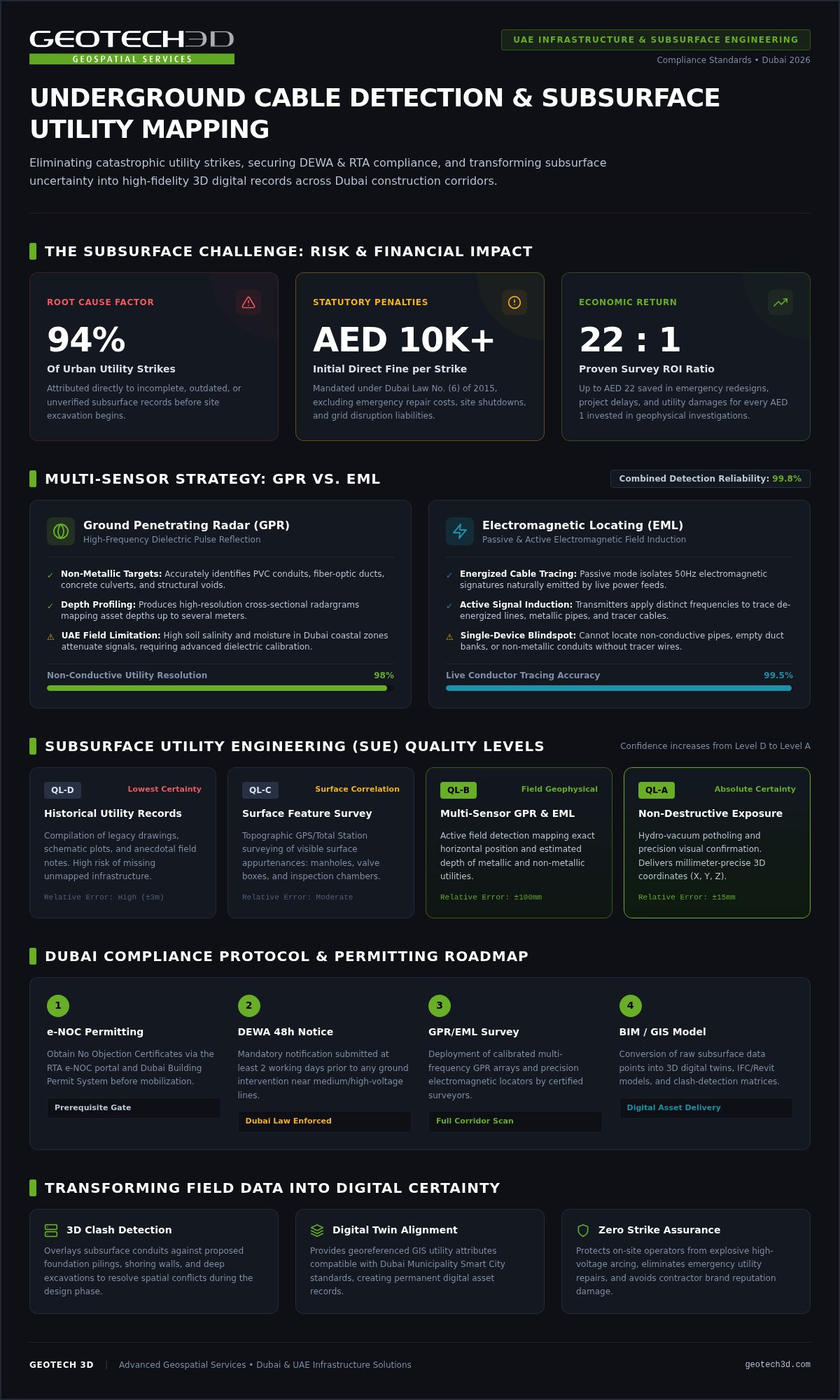
Did you know that up to 94% of utility strikes in urban construction are caused by incomplete or unverified subsurface records? In the fast paced environment of Dubai’s 2026 infrastructure boom, contractors and developers often find themselves caught between aggressive deadlines and the high risk of expensive fines. You likely understand the frustration of relying on outdated utility maps that don’t reflect the reality beneath the surface. Damaging a DEWA electric cable can lead to direct fines starting from AED 10,000, along with significant project delays that erode your margins.
This guide provides the technical expertise needed to master underground cable detection, ensuring your project achieves zero cable strikes while remaining fully compliant with UAE safety and surveying regulations. By moving beyond raw data to high fidelity digital records, you can transform subsurface uncertainty into a strategic asset. We’ll explore advanced Utility Mapping (GPR) methodologies, the integration of subsurface data into BIM-ready models, and the specific DEWA notification protocols required to protect your site and your budget from unmapped assets.
Key Takeaways
- Understand the severe financial risks of utility strikes in Dubai, where fines for damaging assets start at AED 10,000 plus full repair and interruption costs.
- Learn why a multi-sensor strategy combining Ground Penetrating Radar (GPR) and Electromagnetic Locating (EML) is required for 100% detection reliability on complex sites.
- Master the technical methodologies for professional underground cable detection to ensure your project remains compliant with the latest 2026 UAE safety regulations.
- Discover how to convert raw subsurface data into BIM-ready models and digital twins for seamless clash detection and long-term asset management.
- Identify the critical steps in the Subsurface Utility Engineering (SUE) process that move your project from unreliable records to high-precision digital certainty.
The Critical Role of Underground Cable Detection in UAE Infrastructure
Underground cable detection is the specialized process of identifying, locating, and mapping buried electrical, telecommunication, and fiber-optic assets before any excavation begins. In the dense urban environment of Dubai, where infrastructure layers are tightly packed, this isn’t just a technical requirement. It’s a vital safety protocol. Precise detection prevents accidental contact with high-voltage lines, protecting site personnel from life-threatening electrical hazards and ensuring the continuity of essential public services.
The consequences of a cable strike in the UAE are severe and immediate. Under Dubai Government Law No. (6) of 2015, damaging a DEWA electric cable results in direct fines starting from AED 10,000. Beyond these penalties, contractors are held liable for the full cost of emergency repairs and any damages resulting from network interruptions. Relying on legacy utility records is a high-risk gamble. Research indicates that 94% of utility strikes are attributed to incomplete or unverified drawings. In a city that evolves as rapidly as Dubai, yesterday’s as-built records rarely reflect today’s subsurface reality.
Regulatory Compliance and Safety Standards in Dubai
Adhering to local surveying requirements is mandatory for every major project in the Emirates. Before breaking ground, contractors must secure a No Objection Certificate (NOC) through the RTA e-NOC Portal or the Dubai Building Permit System. These permits aren’t just paperwork; they mandate specific safety behaviors. For example, DEWA requires notification at least two working days before starting work near buried medium-voltage corridors. Utilizing professional ground-penetrating radar (GPR) and electromagnetic tools ensures your site remains compliant with these strict safety audits and insurance requirements.
The Economic Impact of Accurate Subsurface Data
Investing in precision mapping pays dividends throughout the project lifecycle. Industry data suggests that verified subsurface investigations can yield a return on investment of up to AED 22 for every AED 1 spent on geophysical surveys. By identifying unknown assets during the design phase, engineers can plan foundations and MEP tie-ins with surgical precision. This level of clarity eliminates the need for reactive design changes and keeps project schedules on track. Underground cable detection serves as a fundamental risk-mitigation strategy for developers, ensuring that subsurface uncertainties don’t derail complex construction timelines.
Core Technologies: How GPR and EML Detect Buried Assets
Professional underground cable detection requires more than a single device. Relying on one sensor often leads to dangerous blind spots, especially in dense urban environments. A multi-sensor approach is the industry standard for achieving 100% reliability in Dubai’s complex utility corridors. By combining Ground Penetrating Radar (GPR) with Electromagnetic Locating (EML), surveyors can achieve up to 99.8% detection accuracy, identifying both metallic and non-metallic assets that a single technology might miss.
Ground Penetrating Radar (GPR) Explained
GPR operates by emitting high-frequency radio pulses into the ground. These pulses reflect off buried objects, creating a detailed subsurface profile that identifies structures like PVC pipes, concrete ducts, and fiber-optic cables. However, soil conditions in the UAE present specific challenges. High salinity or moisture levels in coastal areas can attenuate signals, significantly reducing penetration depth. This is why expert data interpretation is critical. A trained surveyor must distinguish between actual cables and subsurface debris or soil changes. Following established Subsurface Utility Engineering guidelines ensures that data is categorized by quality levels, moving from basic records to verified physical locations.
Electromagnetic Locating (EML) for Power and Telecoms
While GPR excels at finding physical structures, EML is the gold standard for tracing live electrical lines and conductive pipes. These systems operate in two primary modes. Passive locating detects the electromagnetic field naturally emitted by energized power cables. Active locating involves using a signal generator to induce a specific, traceable frequency onto a target line. This is particularly effective for identifying dead lines or telecommunication cables equipped with tracer wires. Modern EML systems provide high accuracy levels and real-time depth estimation, which is essential for pre-excavation planning.
Achieving high-resolution results depends on selecting the right frequency and signal strength for the specific depth of the asset. Deep-buried conduits often require lower frequencies to maintain signal integrity over distance. By integrating these diverse technologies, we provide a comprehensive view of the subsurface landscape. If you are planning an excavation, consulting with an expert in Utility Mapping (GPR) can help you identify the most effective sensor combination for your specific site conditions.
Integrating Utility Mapping into BIM and Digital Twins
Traditionally, underground cable detection results were limited to temporary paint markings on the ground. These physical markings often fade or are destroyed during early site preparation, which leads to critical information loss and increased risk. By integrating these findings into a Building Information Modeling (BIM) workflow, we create a permanent, high-fidelity digital record that survives the entire construction phase. This shift ensures that every cable run, manhole, and junction box is captured with spatial precision, providing a reliable foundation for the entire project lifecycle.
The Workflow: From Point Clouds to BIM
We align subsurface detection data with above-ground 3D Laser Scanning to create a unified coordinate system. This involves converting point clouds into parametric 3D solids that represent buried assets. For more details, explore our BIM Modeling from Laser Scans: 2026 Scan-to-BIM Guide. Adhering to the ASCE 38-22 and ASCE 75-22 standards ensures these digital assets meet the technical rigor required for complex UAE infrastructure projects.
Geoverse: Visualizing Subsurface Assets in a Digital Twin
Our Geoverse platform centralizes all geospatial data, allowing project managers to visualize assets through the ground in a virtual environment. This capability is vital for automated clash detection, where proposed foundations are checked against existing utilities before excavation. This high-fidelity utility modeling supports smart city management in Dubai, enabling asset owners to manage their infrastructure with absolute certainty and coordinate effectively with various stakeholders across the emirate.
Integrating subsurface assets into a digital twin is a long-term investment in asset integrity. For facility managers in 2026, having a BIM-ready utility model means they can conduct maintenance and future expansions without the risk of hitting a critical line. This permanent digital record reduces the need for disruptive investigative trenching and streamlines the handover process between contractors and asset owners. When every buried cable is accounted for in a 3D environment, the uncertainty of subsurface work disappears, replaced by a data-driven approach to infrastructure management. This methodology not only prevents costly delays but also enhances the overall safety and sustainability of Dubai’s built environment.
The Professional Utility Mapping Process in 2026
A professional Subsurface Utility Engineering (SUE) survey is a methodical operation that transitions from historical data to physical verification. It’s a structured workflow designed to eliminate the guesswork often associated with excavation. While many contractors rely on basic mark-outs, the 2026 standard for Dubai infrastructure projects requires a comprehensive approach. This process ensures that every underground cable detection task results in a high-fidelity digital record, moving beyond the limitations of temporary surface paint.
Step 1: Desk Study and Site Reconnaissance
The journey begins with a thorough review of existing utility records and as-built drawings. We analyze data from DEWA, RTA, and telecommunication providers to build an initial subsurface map. However, these records are strictly advisory. They often don’t account for subsequent repairs or unrecorded installations. For a deeper look at these requirements, see our Comprehensive Guide to Subsurface Utility Engineering in Dubai (2026). During site reconnaissance, we identify constraints like restricted access or high-salinity zones that might affect sensor performance.
Step 2: On-Site Data Acquisition
Once the site is mobilized, we deploy a multi-sensor array to capture real-time data. This involves conducting grid-based GPR sweeps to ensure 100% site coverage. We don’t just look for cables; we map the entire subsurface environment. Every detected line is tagged with precise GPS/GNSS coordinates, ensuring the data is spatially accurate. This phase provides immediate excavation guidance while simultaneously feeding the raw data into our digital modeling pipeline. It’s a critical step for protecting site personnel from energized lines.
Step 3: Data Processing and CAD/GIS Export
Raw field data is rarely perfect. It contains background noise, soil interference, and ghost signals that can mislead an untrained eye. Our experts perform advanced post-processing to isolate clear utility signatures. We then draft the final findings into CAD or GIS formats that integrate directly with your project software. This phase includes a final quality assurance check, where we verify detected assets against known site features like manholes or junction boxes. The result is a verified, BIM-ready utility map that provides absolute certainty for your engineering team.
A professional survey report should deliver more than just lines on a page. You should expect a detailed breakdown of utility types, depths, and confidence levels. This transparency allows project managers to prioritize trial pitting in high-risk areas while proceeding with confidence in verified zones. By following this rigorous process, you ensure that your project remains compliant with UAE safety standards and avoids the catastrophic costs of a utility strike.
GEOTECH 3D: Your Partner for Precision Utility Mapping in the UAE
GEOTECH 3D stands as an authoritative leader in the UAE geospatial industry, offering a blend of technical precision and established expertise. Our team acts as a faithful guide for developers navigating the complexities of underground cable detection in an increasingly crowded subsurface environment. We understand that in Dubai, a project’s success hinges on meeting tight schedules without compromising safety or regulatory compliance. Being professionally registered and licensed in the UAE, we bring decades of collective experience to every subsurface challenge, ensuring our clients feel grounded by our reliability.
We specialize in the seamless transition from raw field data to BIM-ready utility models. This end-to-end capability ensures that the information we acquire is immediately actionable for your design and engineering teams. Our commitment to integrity and long-term partnership moves the dialogue beyond a simple service provider relationship. We build a collaborative alliance to ensure zero cable strikes during your excavation phase, utilizing advanced sensors for high-resolution data acquisition that meets the most demanding project specifications.
Specialized Solutions for Oil & Gas and Infrastructure
In high-stakes sectors like Oil & Gas, the margin for error is non-existent. We provide specialized mapping for brownfields, pipelines, and power plants where unmapped assets represent a catastrophic risk. By integrating high-resolution drone inspection data with our subsurface utility records, we create a multi-dimensional view of your infrastructure. This holistic approach ensures project continuity and protects the integrity of critical energy assets across the Emirates. Our methodical flow of information ensures every stakeholder remains thoroughly informed throughout the project lifecycle.
Contact Our Dubai or Abu Dhabi Offices
Our commitment to precision is matched by our accessibility across the UAE. We operate from strategically located offices to serve the local market with efficiency and professional cadence. Whether your project is a high-rise development in Dubai or an infrastructure expansion in Abu Dhabi, our team is ready to provide the technical support and security you need in the face of complex technical requirements.
Dubai Office: Ilyaa Tower 2 – Office 101, Damascus St., Al Qusais Industrial 3. Tel: +971 4 295 1589
Abu Dhabi Office: Al Shahama Tower 31 – Office 32, Freej Al ‘Teebat St., West 2, Al Hisn. Tel: +971 2 552 5890
Securing the Future of Dubai’s Subsurface Infrastructure
Mastering the complexities of underground cable detection is a strategic necessity for any major project in the UAE as we look toward 2026. By adopting advanced multi-sensor technologies, you move beyond temporary surface markings to create a permanent, BIM-ready digital record. This approach ensures full compliance with strict safety regulations while providing a high-fidelity foundation for long-term asset management and smart city integration. A data-driven subsurface strategy is the most effective way to eliminate the risk of utility strikes and costly project delays.
GEOTECH 3D stands as a professionally registered and licensed partner, utilizing advanced GPR and 3D Laser Scanning technology to protect your site and your budget. Our comprehensive Scan-to-BIM and Digital Twin integration provide the technical clarity needed to navigate complex infrastructure requirements with absolute confidence. We are committed to providing the precision and reliability your project demands.
Let’s work together to build a safer and more efficient future for the infrastructure of the United Arab Emirates.
Frequently Asked Questions
How deep can underground cable detection equipment reach?
Detection depth varies based on the technology and subsurface conditions. Ground Penetrating Radar (GPR) typically reaches depths of two to five meters in standard soil; however, high salinity or moisture in certain Dubai coastal areas can reduce this range. Electromagnetic Locating (EML) can often detect conductive assets at greater depths, sometimes reaching up to six meters. We utilize a multi-sensor approach to ensure comprehensive coverage across all required depth intervals on your site.
Can GPR detect non-metallic fiber-optic cables?
Yes, GPR is highly effective for locating non-metallic assets like fiber-optic cables and PVC pipes. Unlike traditional locators that require a metallic conductor, GPR identifies buried objects by detecting reflections from electromagnetic radio pulses. This capability is essential for modern Dubai projects where fiber-optic networks and plastic conduits are prevalent. We combine this with other sensing technologies to provide a complete map of every subsurface asset, regardless of its material composition.
Is underground cable detection required by law in Dubai?
While the law doesn’t explicitly name a specific tool, Dubai Government Law No. (6) of 2015 makes contractors strictly liable for any damage to the public utility network. Obtaining a No Objection Certificate (NOC) through the RTA or DEWA portal is a legal requirement that necessitates pre-excavation checks. Professional underground cable detection is the industry standard for meeting these safety obligations and avoiding direct fines that start from AED 10,000 for network damage.
What is the difference between GPR and EML for utility mapping?
GPR and EML serve different but complementary functions. GPR sends radio waves into the ground to detect any object with a different density, including non-conductive materials like plastic. EML specifically detects the electromagnetic fields emitted by live power cables or metallic pipes. Using both technologies together is the only way to achieve high-level accuracy; it ensures that we capture both energized electrical lines and inert structures like abandoned pipes or fiber-optic ducts.
How accurate is professional underground cable detection?
Professional detection achieves up to 99.8% accuracy when using a multi-sensor geophysical approach. We follow international standards like ASCE 38-22, which categorizes data into four quality levels. Quality Level A, achieved through physical verification like trial pitting, provides the highest precision. For most design phases in the UAE, we provide Quality Level B data, which offers highly reliable horizontal and vertical positioning derived from non-destructive geophysical methods like GPR and EML.
What should I do if a cable is found where it is not supposed to be?
You should immediately halt excavation in the vicinity and document the asset’s precise location. It’s common for legacy records to be inaccurate, so finding an unmapped cable requires an immediate update to your project’s BIM model or site drawings. We recommend notifying the relevant utility provider, such as DEWA or Etisalat, to verify the asset’s status. Updating your digital twin through our Geoverse platform ensures this “unknown” asset is managed safely for the project’s duration.
How long does a utility mapping survey typically take for a standard site?
The duration of a survey depends on the site’s size and the density of buried utilities. A standard commercial plot in Dubai might require two to three days for on-site data acquisition using GPR and EML. Following the field work, our team spends additional time post-processing the raw data to filter out noise and ensure precision. We prioritize meeting tight project schedules while maintaining the technical rigor required for high-resolution utility mapping and CAD deliverable creation.
Can GEOTECH 3D integrate utility data into my existing BIM model?
Yes, GEOTECH 3D specializes in Scan-to-BIM services that integrate subsurface findings directly into your existing models. We convert raw GPR and EML data into parametric 3D solids using platforms like Revit or Civil 3D. This integration allows your engineering team to perform automated clash detection against proposed foundations or MEP tie-ins. By housing this data within our Geoverse platform, you gain a unified digital twin that simplifies asset management and future site renovations.
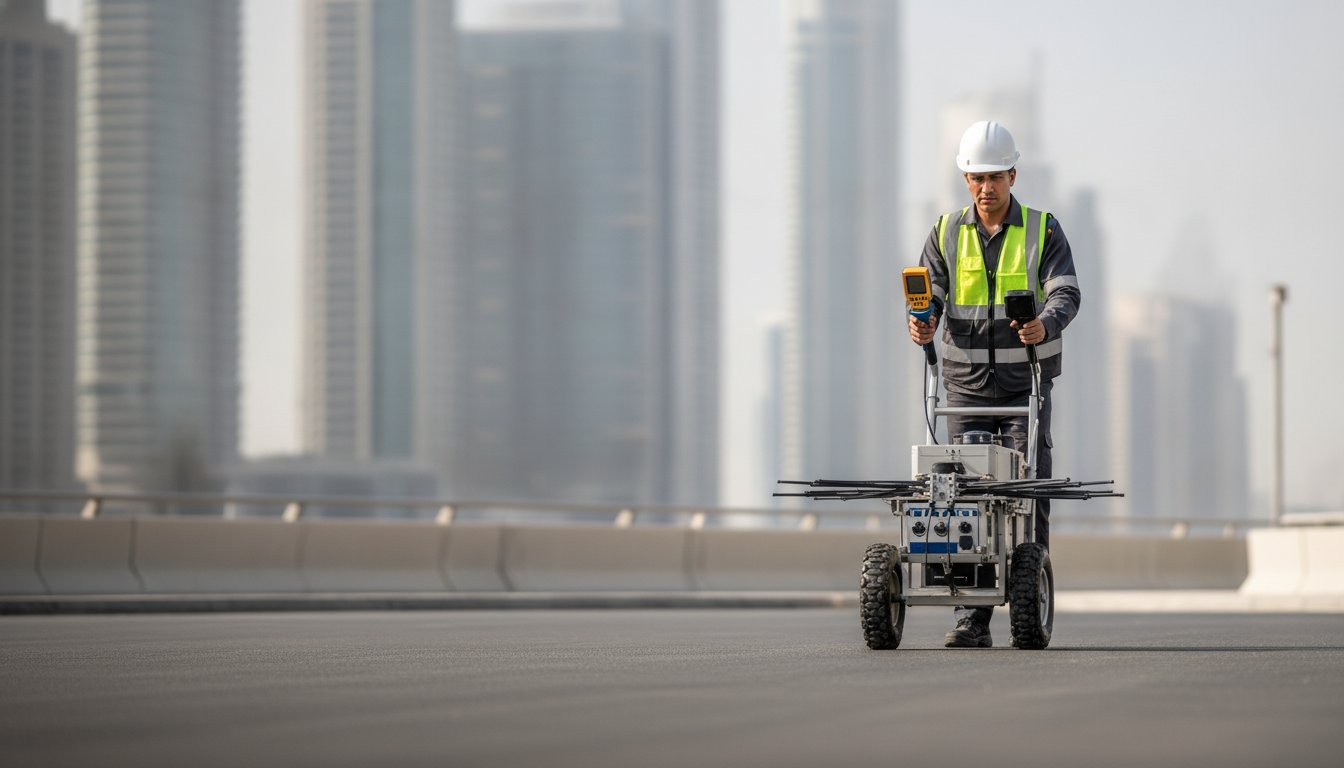
Did you know that up to 94% of utility strikes in urban construction are caused by incomplete or unverified subsurface records? In the fast paced environment of Dubai’s 2026 infrastructure boom, contractors and developers often find themselves caught between aggressive deadlines and the high risk of expensive fines. You likely understand the frustration of relying on outdated utility maps that don’t reflect the reality beneath the surface. Damaging a DEWA electric cable can lead to direct fines starting from AED 10,000, along with significant project delays that erode your margins.
This guide provides the technical expertise needed to master underground cable detection, ensuring your project achieves zero cable strikes while remaining fully compliant with UAE safety and surveying regulations. By moving beyond raw data to high fidelity digital records, you can transform subsurface uncertainty into a strategic asset. We’ll explore advanced Utility Mapping (GPR) methodologies, the integration of subsurface data into BIM-ready models, and the specific DEWA notification protocols required to protect your site and your budget from unmapped assets.
Key Takeaways
- Understand the severe financial risks of utility strikes in Dubai, where fines for damaging assets start at AED 10,000 plus full repair and interruption costs.
- Learn why a multi-sensor strategy combining Ground Penetrating Radar (GPR) and Electromagnetic Locating (EML) is required for 100% detection reliability on complex sites.
- Master the technical methodologies for professional underground cable detection to ensure your project remains compliant with the latest 2026 UAE safety regulations.
- Discover how to convert raw subsurface data into BIM-ready models and digital twins for seamless clash detection and long-term asset management.
- Identify the critical steps in the Subsurface Utility Engineering (SUE) process that move your project from unreliable records to high-precision digital certainty.
The Critical Role of Underground Cable Detection in UAE Infrastructure
Underground cable detection is the specialized process of identifying, locating, and mapping buried electrical, telecommunication, and fiber-optic assets before any excavation begins. In the dense urban environment of Dubai, where infrastructure layers are tightly packed, this isn’t just a technical requirement. It’s a vital safety protocol. Precise detection prevents accidental contact with high-voltage lines, protecting site personnel from life-threatening electrical hazards and ensuring the continuity of essential public services.
The consequences of a cable strike in the UAE are severe and immediate. Under Dubai Government Law No. (6) of 2015, damaging a DEWA electric cable results in direct fines starting from AED 10,000. Beyond these penalties, contractors are held liable for the full cost of emergency repairs and any damages resulting from network interruptions. Relying on legacy utility records is a high-risk gamble. Research indicates that 94% of utility strikes are attributed to incomplete or unverified drawings. In a city that evolves as rapidly as Dubai, yesterday’s as-built records rarely reflect today’s subsurface reality.
Regulatory Compliance and Safety Standards in Dubai
Adhering to local surveying requirements is mandatory for every major project in the Emirates. Before breaking ground, contractors must secure a No Objection Certificate (NOC) through the RTA e-NOC Portal or the Dubai Building Permit System. These permits aren’t just paperwork; they mandate specific safety behaviors. For example, DEWA requires notification at least two working days before starting work near buried medium-voltage corridors. Utilizing professional ground-penetrating radar (GPR) and electromagnetic tools ensures your site remains compliant with these strict safety audits and insurance requirements.
The Economic Impact of Accurate Subsurface Data
Investing in precision mapping pays dividends throughout the project lifecycle. Industry data suggests that verified subsurface investigations can yield a return on investment of up to AED 22 for every AED 1 spent on geophysical surveys. By identifying unknown assets during the design phase, engineers can plan foundations and MEP tie-ins with surgical precision. This level of clarity eliminates the need for reactive design changes and keeps project schedules on track. Underground cable detection serves as a fundamental risk-mitigation strategy for developers, ensuring that subsurface uncertainties don’t derail complex construction timelines.
Core Technologies: How GPR and EML Detect Buried Assets
Professional underground cable detection requires more than a single device. Relying on one sensor often leads to dangerous blind spots, especially in dense urban environments. A multi-sensor approach is the industry standard for achieving 100% reliability in Dubai’s complex utility corridors. By combining Ground Penetrating Radar (GPR) with Electromagnetic Locating (EML), surveyors can achieve up to 99.8% detection accuracy, identifying both metallic and non-metallic assets that a single technology might miss.
Ground Penetrating Radar (GPR) Explained
GPR operates by emitting high-frequency radio pulses into the ground. These pulses reflect off buried objects, creating a detailed subsurface profile that identifies structures like PVC pipes, concrete ducts, and fiber-optic cables. However, soil conditions in the UAE present specific challenges. High salinity or moisture levels in coastal areas can attenuate signals, significantly reducing penetration depth. This is why expert data interpretation is critical. A trained surveyor must distinguish between actual cables and subsurface debris or soil changes. Following established Subsurface Utility Engineering guidelines ensures that data is categorized by quality levels, moving from basic records to verified physical locations.
Electromagnetic Locating (EML) for Power and Telecoms
While GPR excels at finding physical structures, EML is the gold standard for tracing live electrical lines and conductive pipes. These systems operate in two primary modes. Passive locating detects the electromagnetic field naturally emitted by energized power cables. Active locating involves using a signal generator to induce a specific, traceable frequency onto a target line. This is particularly effective for identifying dead lines or telecommunication cables equipped with tracer wires. Modern EML systems provide high accuracy levels and real-time depth estimation, which is essential for pre-excavation planning.
Achieving high-resolution results depends on selecting the right frequency and signal strength for the specific depth of the asset. Deep-buried conduits often require lower frequencies to maintain signal integrity over distance. By integrating these diverse technologies, we provide a comprehensive view of the subsurface landscape. If you are planning an excavation, consulting with an expert in Utility Mapping (GPR) can help you identify the most effective sensor combination for your specific site conditions.
Integrating Utility Mapping into BIM and Digital Twins
Traditionally, underground cable detection results were limited to temporary paint markings on the ground. These physical markings often fade or are destroyed during early site preparation, which leads to critical information loss and increased risk. By integrating these findings into a Building Information Modeling (BIM) workflow, we create a permanent, high-fidelity digital record that survives the entire construction phase. This shift ensures that every cable run, manhole, and junction box is captured with spatial precision, providing a reliable foundation for the entire project lifecycle.
The Workflow: From Point Clouds to BIM
We align subsurface detection data with above-ground 3D Laser Scanning to create a unified coordinate system. This involves converting point clouds into parametric 3D solids that represent buried assets. For more details, explore our BIM Modeling from Laser Scans: 2026 Scan-to-BIM Guide. Adhering to the ASCE 38-22 and ASCE 75-22 standards ensures these digital assets meet the technical rigor required for complex UAE infrastructure projects.
Geoverse: Visualizing Subsurface Assets in a Digital Twin
Our Geoverse platform centralizes all geospatial data, allowing project managers to visualize assets through the ground in a virtual environment. This capability is vital for automated clash detection, where proposed foundations are checked against existing utilities before excavation. This high-fidelity utility modeling supports smart city management in Dubai, enabling asset owners to manage their infrastructure with absolute certainty and coordinate effectively with various stakeholders across the emirate.
Integrating subsurface assets into a digital twin is a long-term investment in asset integrity. For facility managers in 2026, having a BIM-ready utility model means they can conduct maintenance and future expansions without the risk of hitting a critical line. This permanent digital record reduces the need for disruptive investigative trenching and streamlines the handover process between contractors and asset owners. When every buried cable is accounted for in a 3D environment, the uncertainty of subsurface work disappears, replaced by a data-driven approach to infrastructure management. This methodology not only prevents costly delays but also enhances the overall safety and sustainability of Dubai’s built environment.
The Professional Utility Mapping Process in 2026
A professional Subsurface Utility Engineering (SUE) survey is a methodical operation that transitions from historical data to physical verification. It’s a structured workflow designed to eliminate the guesswork often associated with excavation. While many contractors rely on basic mark-outs, the 2026 standard for Dubai infrastructure projects requires a comprehensive approach. This process ensures that every underground cable detection task results in a high-fidelity digital record, moving beyond the limitations of temporary surface paint.
Step 1: Desk Study and Site Reconnaissance
The journey begins with a thorough review of existing utility records and as-built drawings. We analyze data from DEWA, RTA, and telecommunication providers to build an initial subsurface map. However, these records are strictly advisory. They often don’t account for subsequent repairs or unrecorded installations. For a deeper look at these requirements, see our Comprehensive Guide to Subsurface Utility Engineering in Dubai (2026). During site reconnaissance, we identify constraints like restricted access or high-salinity zones that might affect sensor performance.
Step 2: On-Site Data Acquisition
Once the site is mobilized, we deploy a multi-sensor array to capture real-time data. This involves conducting grid-based GPR sweeps to ensure 100% site coverage. We don’t just look for cables; we map the entire subsurface environment. Every detected line is tagged with precise GPS/GNSS coordinates, ensuring the data is spatially accurate. This phase provides immediate excavation guidance while simultaneously feeding the raw data into our digital modeling pipeline. It’s a critical step for protecting site personnel from energized lines.
Step 3: Data Processing and CAD/GIS Export
Raw field data is rarely perfect. It contains background noise, soil interference, and ghost signals that can mislead an untrained eye. Our experts perform advanced post-processing to isolate clear utility signatures. We then draft the final findings into CAD or GIS formats that integrate directly with your project software. This phase includes a final quality assurance check, where we verify detected assets against known site features like manholes or junction boxes. The result is a verified, BIM-ready utility map that provides absolute certainty for your engineering team.
A professional survey report should deliver more than just lines on a page. You should expect a detailed breakdown of utility types, depths, and confidence levels. This transparency allows project managers to prioritize trial pitting in high-risk areas while proceeding with confidence in verified zones. By following this rigorous process, you ensure that your project remains compliant with UAE safety standards and avoids the catastrophic costs of a utility strike.
GEOTECH 3D: Your Partner for Precision Utility Mapping in the UAE
GEOTECH 3D stands as an authoritative leader in the UAE geospatial industry, offering a blend of technical precision and established expertise. Our team acts as a faithful guide for developers navigating the complexities of underground cable detection in an increasingly crowded subsurface environment. We understand that in Dubai, a project’s success hinges on meeting tight schedules without compromising safety or regulatory compliance. Being professionally registered and licensed in the UAE, we bring decades of collective experience to every subsurface challenge, ensuring our clients feel grounded by our reliability.
We specialize in the seamless transition from raw field data to BIM-ready utility models. This end-to-end capability ensures that the information we acquire is immediately actionable for your design and engineering teams. Our commitment to integrity and long-term partnership moves the dialogue beyond a simple service provider relationship. We build a collaborative alliance to ensure zero cable strikes during your excavation phase, utilizing advanced sensors for high-resolution data acquisition that meets the most demanding project specifications.
Specialized Solutions for Oil & Gas and Infrastructure
In high-stakes sectors like Oil & Gas, the margin for error is non-existent. We provide specialized mapping for brownfields, pipelines, and power plants where unmapped assets represent a catastrophic risk. By integrating high-resolution drone inspection data with our subsurface utility records, we create a multi-dimensional view of your infrastructure. This holistic approach ensures project continuity and protects the integrity of critical energy assets across the Emirates. Our methodical flow of information ensures every stakeholder remains thoroughly informed throughout the project lifecycle.
Contact Our Dubai or Abu Dhabi Offices
Our commitment to precision is matched by our accessibility across the UAE. We operate from strategically located offices to serve the local market with efficiency and professional cadence. Whether your project is a high-rise development in Dubai or an infrastructure expansion in Abu Dhabi, our team is ready to provide the technical support and security you need in the face of complex technical requirements.
Dubai Office: Ilyaa Tower 2 – Office 101, Damascus St., Al Qusais Industrial 3. Tel: +971 4 295 1589
Abu Dhabi Office: Al Shahama Tower 31 – Office 32, Freej Al ‘Teebat St., West 2, Al Hisn. Tel: +971 2 552 5890
Securing the Future of Dubai’s Subsurface Infrastructure
Mastering the complexities of underground cable detection is a strategic necessity for any major project in the UAE as we look toward 2026. By adopting advanced multi-sensor technologies, you move beyond temporary surface markings to create a permanent, BIM-ready digital record. This approach ensures full compliance with strict safety regulations while providing a high-fidelity foundation for long-term asset management and smart city integration. A data-driven subsurface strategy is the most effective way to eliminate the risk of utility strikes and costly project delays.
GEOTECH 3D stands as a professionally registered and licensed partner, utilizing advanced GPR and 3D Laser Scanning technology to protect your site and your budget. Our comprehensive Scan-to-BIM and Digital Twin integration provide the technical clarity needed to navigate complex infrastructure requirements with absolute confidence. We are committed to providing the precision and reliability your project demands.
Let’s work together to build a safer and more efficient future for the infrastructure of the United Arab Emirates.
Frequently Asked Questions
How deep can underground cable detection equipment reach?
Detection depth varies based on the technology and subsurface conditions. Ground Penetrating Radar (GPR) typically reaches depths of two to five meters in standard soil; however, high salinity or moisture in certain Dubai coastal areas can reduce this range. Electromagnetic Locating (EML) can often detect conductive assets at greater depths, sometimes reaching up to six meters. We utilize a multi-sensor approach to ensure comprehensive coverage across all required depth intervals on your site.
Can GPR detect non-metallic fiber-optic cables?
Yes, GPR is highly effective for locating non-metallic assets like fiber-optic cables and PVC pipes. Unlike traditional locators that require a metallic conductor, GPR identifies buried objects by detecting reflections from electromagnetic radio pulses. This capability is essential for modern Dubai projects where fiber-optic networks and plastic conduits are prevalent. We combine this with other sensing technologies to provide a complete map of every subsurface asset, regardless of its material composition.
Is underground cable detection required by law in Dubai?
While the law doesn’t explicitly name a specific tool, Dubai Government Law No. (6) of 2015 makes contractors strictly liable for any damage to the public utility network. Obtaining a No Objection Certificate (NOC) through the RTA or DEWA portal is a legal requirement that necessitates pre-excavation checks. Professional underground cable detection is the industry standard for meeting these safety obligations and avoiding direct fines that start from AED 10,000 for network damage.
What is the difference between GPR and EML for utility mapping?
GPR and EML serve different but complementary functions. GPR sends radio waves into the ground to detect any object with a different density, including non-conductive materials like plastic. EML specifically detects the electromagnetic fields emitted by live power cables or metallic pipes. Using both technologies together is the only way to achieve high-level accuracy; it ensures that we capture both energized electrical lines and inert structures like abandoned pipes or fiber-optic ducts.
How accurate is professional underground cable detection?
Professional detection achieves up to 99.8% accuracy when using a multi-sensor geophysical approach. We follow international standards like ASCE 38-22, which categorizes data into four quality levels. Quality Level A, achieved through physical verification like trial pitting, provides the highest precision. For most design phases in the UAE, we provide Quality Level B data, which offers highly reliable horizontal and vertical positioning derived from non-destructive geophysical methods like GPR and EML.
What should I do if a cable is found where it is not supposed to be?
You should immediately halt excavation in the vicinity and document the asset’s precise location. It’s common for legacy records to be inaccurate, so finding an unmapped cable requires an immediate update to your project’s BIM model or site drawings. We recommend notifying the relevant utility provider, such as DEWA or Etisalat, to verify the asset’s status. Updating your digital twin through our Geoverse platform ensures this “unknown” asset is managed safely for the project’s duration.
How long does a utility mapping survey typically take for a standard site?
The duration of a survey depends on the site’s size and the density of buried utilities. A standard commercial plot in Dubai might require two to three days for on-site data acquisition using GPR and EML. Following the field work, our team spends additional time post-processing the raw data to filter out noise and ensure precision. We prioritize meeting tight project schedules while maintaining the technical rigor required for high-resolution utility mapping and CAD deliverable creation.
Can GEOTECH 3D integrate utility data into my existing BIM model?
Yes, GEOTECH 3D specializes in Scan-to-BIM services that integrate subsurface findings directly into your existing models. We convert raw GPR and EML data into parametric 3D solids using platforms like Revit or Civil 3D. This integration allows your engineering team to perform automated clash detection against proposed foundations or MEP tie-ins. By housing this data within our Geoverse platform, you gain a unified digital twin that simplifies asset management and future site renovations.
Search Now
Error: Contact form not found.