

Our Services
Top Drone Surveying Companies in UAE: 2026 Selection Guide
A drone pilot who can capture sharp aerial photos is no longer enough to protect your infrastructure schedule. If you manage major commercial developments across Dubai or Abu Dhabi, you already know that evaluating drone surveying companies in UAE requires far more than comparing flight hours. You’ve likely experienced the real industry bottlenecks: lengthy delays securing dual-layer GCAA and DCAA airspace permits, inaccurate measurements from low-grade equipment, and unorganized point clouds that stall your engineering team because they don’t integrate into existing CAD and BIM environments.
You need verified centimeter-level accuracy and a partner who treats reality capture as a rigorous engineering discipline rather than a standalone flight service. In this 2026 selection guide, you’ll discover the leading aerial surveying firms in the country and learn how to evaluate providers based on regulatory standing, advanced sensor payloads, and Scan-to-BIM integration capabilities. We preview the technical benchmarks that matter most, giving your team the practical framework required to choose a trusted surveying partner for your next capital project.
Key Takeaways
- Master the dual-layer GCAA and DCAA regulatory framework to prevent operational bottlenecks and ensure full flight compliance across Dubai and the Northern Emirates.
- Learn how to evaluate drone surveying companies in UAE using strict technical criteria, including geodetic accuracy benchmarks and multi-sensor payloads like the DJI Zenmuse H20T.
- Discover the critical difference between basic aerial photography and true engineering deliverables that feed seamlessly into CAD and 3D Scanning To BIM pipelines.
- Explore high-precision aerial applications tailored to complex regional assets, from flare-stick inspections in oil and gas to volumetric earthwork tracking on smart city sites.
- Identify the core capabilities required from an integration partner to transform raw aerial point clouds into structured digital twins without data loss.
Navigating the Drone Surveying Landscape in the UAE
Aerial data acquisition across the UAE has evolved into a disciplined engineering practice. Across major construction corridors, industrial energy facilities, and municipal utility networks, commercial flight missions are no longer treated as simple photography runs. In 2026, leading project teams prioritize high-density reality capture that converts physical assets into georeferenced point clouds, surface models, and CAD deliverables. Understanding how modern aerial surveying methodologies perform under regional field constraints is essential. When developers evaluate professional drone surveying companies in UAE, they look for technical teams that combine millimeter-precise spatial capture with strict regulatory compliance.
Regulatory Compliance: GCAA and DCAA Requirements
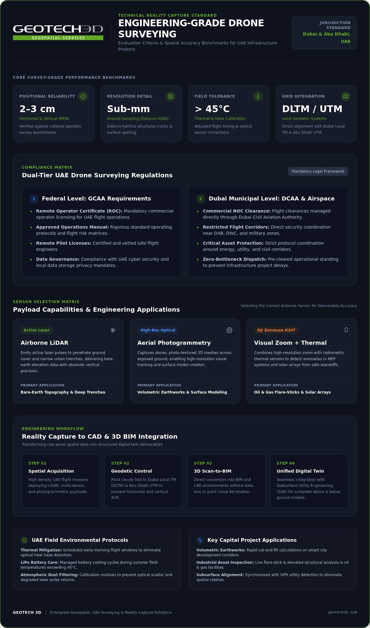
Commercial UAV deployment in the Emirates functions under a rigorous dual-tier legal structure. At the federal level, the General Civil Aviation Authority (GCAA) requires firms to maintain a commercial Remote Operator Certificate (ROC), implement an approved operations manual, and deploy pilots holding valid Remote Pilot Licenses. In Dubai, operators must simultaneously secure operational clearance and a commercial No Objection Certificate (NOC) through the Dubai Civil Aviation Authority (DCAA).
Navigating restricted flight zones around Dubai International Airport (DXB), Al Maktoum International (DWC), and critical military or utility assets requires direct coordination with aviation security teams. Failure to adhere to these flight corridors carries severe financial penalties under UAE federal law. Data governance is equally critical. Professional operators must safeguard sensitive point clouds, infrastructure models, and orthomosaics through secure, local data storage that complies with UAE cyber and privacy mandates.
The Value of Local Expertise in Dubai and Abu Dhabi
Harsh regional operating conditions demand deep environmental experience. Ambient summer temperatures exceeding 45°C strain airframe electronics, reduce lithium-polymer battery efficiency, and cause heat haze that distorts optical sensor clarity. Additionally, airborne dust particulates can degrade optical capture and scatter laser pulses. Seasoned flight crews adjust flight altitudes, timing, and sensor calibrations to maintain absolute data integrity.
Local familiarity also ensures flawless alignment with UAE spatial standards. Field teams must seamlessly tie geodetic ground control points into Dubai Local TM (DLTM) and Abu Dhabi UTM grid systems to prevent horizontal and vertical drift. When building a complete digital site model, pairing uncrewed aerial mapping with comprehensive Subsurface Utility Engineering Dubai workflows ensures above-ground terrain and below-ground utility networks align without costly clashes.
Key Criteria for Evaluating Drone Surveying Companies
Selecting an aerial mapping partner requires looking well beyond airframe hardware or flight hours. When vetting drone surveying companies in UAE, engineering teams must scrutinize end-to-end data pipelines, calibration rigor, and payload flexibility. The difference between a commercial toy and an enterprise reality capture solution comes down to measurable positional reliability. Survey-grade accuracy means delivering root-mean-square error (RMSE) within two to three centimeters horizontally and vertically, verified against established national geodetic benchmarks.
Sensor Technology and Payload Versatility
High-precision deliverables depend on deploying the correct payload for each specific inspection or topographical objective:
- Visual and Radiometric Thermal: Advanced multi-sensor systems like the DJI Zenmuse H20T combine high-resolution zoom with radiometric thermal sensors. This dual capability allows teams to pinpoint thermal anomalies in MEP systems or solar arrays while maintaining high-resolution visual tracking from safe operational standoffs.
- LiDAR vs. Photogrammetry: Aerial photogrammetry delivers dense, photo-textured meshes across exposed ground, but it fails in dense vegetation or narrow urban trenches. Airborne LiDAR emits active laser pulses that penetrate ground cover to map underlying bare earth with absolute vertical precision.
- High-Resolution Detail: Sub-millimeter ground sampling distances (GSD) ensure façade inspections detect hairline structural cracks and surface spalling before they escalate into structural hazards.
Data Quality and Workflow Integration
Raw point clouds and unrectified orthomosaics offer minimal value to structural consultants. The true benchmark of top-tier drone surveying companies in UAE is their ability to transform unstructured aerial points into clean, parametric assets compatible with Autodesk Revit, AutoCAD Civil 3D, and municipal GIS databases. Achieving this level of precision requires meticulous field survey controls. Even RTK-enabled flight systems require strategically placed Ground Control Points (GCPs) and independent checkpoints surveyed with dual-frequency GNSS receivers to eliminate cumulative spatial drift across large corridors.
Equally critical is field safety within active, high-risk industrial environments. Survey providers operating around live substations, refineries, or complex marine assets must enforce strict risk assessments, fail-safe battery telemetry, and comprehensive third-party liability insurance. If your infrastructure project requires dependable spatial capture that fits straight into your engineering design software, partnering with GEOTECH 3D ensures every flight delivers mathematically verified, BIM-ready intelligence.
Leading Drone Surveying Providers in the UAE for 2026
The aerial surveying market in the Emirates divides into two distinct operational models: fleet-driven aerial operators and specialized geospatial engineering firms. While broad fleet operators focus heavily on rapid image capture over expansive terrain, complex architecture and high-risk industrial facilities demand technical integration. Choosing between drone surveying companies in UAE hinges on whether your scope requires high-altitude photogrammetric mapping or millimeter-accurate engineering models tied to terrestrial reality capture.
Enterprise-Scale Service Providers
Large-scale fleet providers excel at broad-brush monitoring. These operators deploy standardized multi-rotor and fixed-wing fleets to cover hundreds of hectares of desert terrain, agricultural tracts, or municipal zones. Their operations frequently adopt a drone-as-a-service model, delivering recurring progress photography and basic orthophotos directly through web portals. While this volume-based approach suits broad earthwork volume tracking or general site surveillance, it often lacks the granular downstream processing required for structural engineering, where raw points must translate directly into intelligent BIM components.
Specialized Geospatial Integration Firms
For capital infrastructure, industrial plants, and commercial developments, integration firms bridge the critical gap between uncrewed flight operations and CAD engineering. These providers do not treat aerial capture as an isolated activity. Instead, they fuse high-altitude aerial photogrammetry and aerial LiDAR with high-resolution terrestrial laser scanning, mobile mapping, and underground utility data into a unified coordinate framework.
This integration tier is anchored by technical authorities like GEOTECH 3D. Operating with fully registered engineering offices in both Dubai and Abu Dhabi, GEOTECH 3D delivers end-to-end reality capture tailored to complex regional requirements. Rather than handing clients disconnected point cloud files, the firm provides structured engineering deliverables:
- Seamless 3D Scanning To BIM: Direct conversion of aerial and terrestrial point clouds into parametric Revit models (LOD 200 through LOD 400), ensuring immediate coordination for MEP and structural consultants.
- Industrial Aerial Inspection: High-precision condition assessments across live oil and gas flare stacks, marine berths, and building envelopes using the DJI Zenmuse H20T multi-sensor payload.
- Digital Twin Continuity: Streaming massive spatial datasets into the Geoverse Platform to power smart city initiatives, municipal GIS updates, and long-term asset management.
When selecting among top drone surveying companies in UAE, teams managing complex capital assets gain far greater value from partners who combine dual-emirate licensing with advanced downstream modeling expertise.
Industry-Specific Applications of Aerial Mapping
Aerial reality capture is not a one-size-fits-all discipline. Different economic sectors across the Emirates require specialized sensor configurations, rigorous flight planning, and tailored modeling pipelines. The most capable drone surveying companies in UAE adapt their methodologies to meet the precise technical demands of high-risk operating environments, from remote desert infrastructure to dense urban high-rises.
Oil & Gas and Marine Sector Surveys
Operating industrial energy facilities presents severe safety challenges. Conducting aerial flare-stick surveys eliminates the requirement to shut down active production lines or deploy rope-access personnel into hazardous thermal zones. Uncrewed platforms equipped with radiometric thermal and optical zoom sensors inspect operational flare tips from safe standoff distances, identifying refractory lining degradation, burner anomalies, and internal structural fatigue.
In offshore and marine environments, aerial surveys capture complex topside infrastructure, pipeline corridors, and hull fabrication progress across naval shipyards. Feeding these detailed spatial point clouds into a digital twin for asset lifecycle management allows plant operators to monitor metal loss, corrosion patterns, and deformation over decades of asset operation.
Construction and Urban Development
Civil engineering contractors across Dubai and Abu Dhabi rely on repeated drone flights to maintain schedule integrity. Rapid topographic mapping enables high-precision volumetric calculations for bulk earthworks, verifying cut-and-fill quantities against digital terrain models with verified consistency. Flight teams also conduct automated progress monitoring across master-planned communities, delivering clear visual and spatial proof of milestone completion to asset owners.
Specialized flight profiles support vertical assets as well. High-resolution optical sensors perform systematic façade inspections to identify delamination or cladding defects. On expansive rooftops, thermal payloads assess solar panel arrays for cell micro-cracks and defective bypass diodes. Survey teams even deploy collision-tolerant drones into confined MEP spaces for vertical shaft and ceiling inspections. Feeding this comprehensive aerial intelligence into standardized 2026 Scan-to-BIM guides ensures structural components match initial architectural design files precisely before handover.
Why GEOTECH 3D is the UAE’s Leading Partner for Aerial Data
Engineering projects across Dubai and Abu Dhabi demand certainty from inception to handover. GEOTECH 3D stands out among drone surveying companies in UAE by providing an established institutional backbone backed by decades of collective field expertise. Rather than operating simply as an equipment flight vendor, the company acts as a comprehensive geospatial consultancy. Flight operations, sensor selections, and computational modeling are handled entirely in-house, ensuring complete control over safety protocols and tight project delivery schedules.
The Geoverse Platform and Digital Twin Innovation
Capturing billions of high-precision spatial points creates massive data management challenges for municipal planners and developers. GEOTECH 3D solves this through the Geoverse Platform, an enterprise geospatial visualization engine capable of rendering massive point cloud datasets without decimation or lag. This environment supports smart city initiatives through spatial analysis, comprehensive city modeling, and interactive municipal GIS integration. By unifying aerial imagery, laser scans, and cadastral records into a centralized digital twin, stakeholders can inspect structural geometry and run cross-sectional analyses directly through web browsers.
Expertise in 3D Scanning To BIM and CAD Integration
Data is only as valuable as its downstream utility. While many drone surveying companies in UAE deliver raw point clouds that overwhelm architectural software, GEOTECH 3D bridges the gap between field sensors and BIM execution plans. Using advanced multi-sensor platforms such as the DJI Zenmuse H20T alongside terrestrial scanners, the engineering team extracts precise geometric wireframes, structural volumes, and parametric elements for instant import into Autodesk Revit and Civil 3D.
GEOTECH 3D maintains fully staffed, licensed offices in Dubai and Abu Dhabi to coordinate flight permissions, field surveys, and spatial deliveries across the Emirates:
- Dubai Head Office: Ilyaa Tower 2 – Office 101, Damascus St., Al Qusais Industrial 3 | Tel: +971 4 295 1589
- Abu Dhabi Office: Al Shahama Tower 31 – Office 32 | Tel: +971 2 552 5890
- Email: info@geotech3d.com
Whether you require baseline topographic contours, specialized thermal flare inspections, or turnkey 3D Scanning To BIM delivery, GEOTECH 3D provides the verified precision and regulatory licensing your capital project requires.
Selecting Your Geospatial Partner for Future-Ready UAE Infrastructure
Delivering complex capital developments across the Emirates demands uncompromising spatial accuracy, total regulatory compliance, and dependable software integration. Vetting drone surveying companies in UAE comes down to choosing a collaborative partner that bridges the divide between uncrewed flight missions and CAD execution. When your aerial team pairs advanced multi-sensor payloads like the DJI Zenmuse H20T with specialized 3D Scanning To BIM workflows, field measurements translate into reliable, clash-free design models.
With registered engineering offices in Dubai and Abu Dhabi, GEOTECH 3D navigates local airspace permits and geodetic calibrations with seasoned technical authority. We ensure your project milestones stay protected while converting raw aerial point clouds into enduring digital twins.
Empower your engineering teams with millimeter-level clarity and lead your next infrastructure venture with complete technical confidence.
Frequently Asked Questions
What are the legal requirements for drone surveying in Dubai?
Commercial drone operations require dual authorization from the General Civil Aviation Authority (GCAA) and the Dubai Civil Aviation Authority (DCAA). Operators must hold a valid Remote Operator Certificate (ROC), employ certified remote pilots, and register every commercial aircraft exceeding 250 grams. Additionally, firms must secure mission-specific DCAA No Objection Certificates (NOCs) and carry compliant third-party liability insurance before entering any local airspace.
How accurate is drone-based topographic mapping compared to traditional surveying?
When conducted by qualified drone surveying companies in UAE using RTK flight systems and surveyed Ground Control Points, aerial mapping delivers horizontal and vertical precision within two to three centimeters. This accuracy matches conventional total station surveys over open terrain. Drones capture millions of georeferenced data points across large sites in hours rather than weeks, dramatically accelerating civil earthwork calculations.
Which industries in the UAE benefit most from drone thermal inspections?
The oil and gas, marine, and power utility sectors benefit significantly from aerial thermal assessments. Facility managers use radiometric thermal payloads to inspect live flare stacks, offshore pipelines, and chemical storage tanks without taking production offline. Commercial solar farms also rely on thermal flights to detect micro-cracks, dust soiling, and defective string diodes across thousands of photovoltaic modules quickly.
How long does it typically take to obtain DCAA or GCAA permits for a survey?
Permit lead times vary depending on site proximity to airports, critical infrastructure, and restricted airspace zones. Established commercial operators maintain active corporate licenses and standardized documentation with aviation authorities, which streamlines project clearance. However, engineering teams should always account for regulatory review cycles during project scheduling rather than anticipating immediate, same-day site access.
Can drone data be directly converted into a BIM-ready model?
Yes, but raw aerial imagery requires specialized downstream processing before import into architectural software. Leading geospatial providers convert dense point clouds into parametric Revit models using integrated 3D Scanning To BIM workflows. By combining aerial photogrammetry or LiDAR with terrestrial laser scans, engineers generate clash-free geometric assets that comply with project-specific Levels of Development (LOD).
What is the role of the DJI Zenmuse H20T in industrial inspections?
The DJI Zenmuse H20T is an integrated multi-sensor payload combining a wide camera, a high-magnification optical zoom sensor, a radiometric thermal camera, and a laser rangefinder. In high-risk environments like oil refineries, flare stacks, and tall façades, this setup allows survey teams to pinpoint thermal anomalies and structural defects from safe operational standoffs without risking personnel.
Does GEOTECH 3D provide services in Abu Dhabi as well as Dubai?
GEOTECH 3D operates fully staffed, registered corporate offices in both Dubai and Abu Dhabi. This dual-emirate presence allows the technical team to navigate local municipal regulations, coordinate flight clearances across both jurisdictions, and deploy field survey crews efficiently throughout the United Arab Emirates.
How does the Geoverse Platform assist in asset management?
The Geoverse Platform renders massive, complex spatial datasets and point clouds without decimation, allowing users to interact with detailed digital twins directly in web browsers. Asset managers and municipal planners use it for spatial analysis, infrastructure condition tracking, and city modeling. It integrates multi-source geospatial data into a single, accessible operational view across an asset’s entire lifecycle.

A drone pilot who can capture sharp aerial photos is no longer enough to protect your infrastructure schedule. If you manage major commercial developments across Dubai or Abu Dhabi, you already know that evaluating drone surveying companies in UAE requires far more than comparing flight hours. You’ve likely experienced the real industry bottlenecks: lengthy delays securing dual-layer GCAA and DCAA airspace permits, inaccurate measurements from low-grade equipment, and unorganized point clouds that stall your engineering team because they don’t integrate into existing CAD and BIM environments.
You need verified centimeter-level accuracy and a partner who treats reality capture as a rigorous engineering discipline rather than a standalone flight service. In this 2026 selection guide, you’ll discover the leading aerial surveying firms in the country and learn how to evaluate providers based on regulatory standing, advanced sensor payloads, and Scan-to-BIM integration capabilities. We preview the technical benchmarks that matter most, giving your team the practical framework required to choose a trusted surveying partner for your next capital project.
Key Takeaways
- Master the dual-layer GCAA and DCAA regulatory framework to prevent operational bottlenecks and ensure full flight compliance across Dubai and the Northern Emirates.
- Learn how to evaluate drone surveying companies in UAE using strict technical criteria, including geodetic accuracy benchmarks and multi-sensor payloads like the DJI Zenmuse H20T.
- Discover the critical difference between basic aerial photography and true engineering deliverables that feed seamlessly into CAD and 3D Scanning To BIM pipelines.
- Explore high-precision aerial applications tailored to complex regional assets, from flare-stick inspections in oil and gas to volumetric earthwork tracking on smart city sites.
- Identify the core capabilities required from an integration partner to transform raw aerial point clouds into structured digital twins without data loss.
Navigating the Drone Surveying Landscape in the UAE
Aerial data acquisition across the UAE has evolved into a disciplined engineering practice. Across major construction corridors, industrial energy facilities, and municipal utility networks, commercial flight missions are no longer treated as simple photography runs. In 2026, leading project teams prioritize high-density reality capture that converts physical assets into georeferenced point clouds, surface models, and CAD deliverables. Understanding how modern aerial surveying methodologies perform under regional field constraints is essential. When developers evaluate professional drone surveying companies in UAE, they look for technical teams that combine millimeter-precise spatial capture with strict regulatory compliance.
Regulatory Compliance: GCAA and DCAA Requirements
Commercial UAV deployment in the Emirates functions under a rigorous dual-tier legal structure. At the federal level, the General Civil Aviation Authority (GCAA) requires firms to maintain a commercial Remote Operator Certificate (ROC), implement an approved operations manual, and deploy pilots holding valid Remote Pilot Licenses. In Dubai, operators must simultaneously secure operational clearance and a commercial No Objection Certificate (NOC) through the Dubai Civil Aviation Authority (DCAA).
Navigating restricted flight zones around Dubai International Airport (DXB), Al Maktoum International (DWC), and critical military or utility assets requires direct coordination with aviation security teams. Failure to adhere to these flight corridors carries severe financial penalties under UAE federal law. Data governance is equally critical. Professional operators must safeguard sensitive point clouds, infrastructure models, and orthomosaics through secure, local data storage that complies with UAE cyber and privacy mandates.
The Value of Local Expertise in Dubai and Abu Dhabi
Harsh regional operating conditions demand deep environmental experience. Ambient summer temperatures exceeding 45°C strain airframe electronics, reduce lithium-polymer battery efficiency, and cause heat haze that distorts optical sensor clarity. Additionally, airborne dust particulates can degrade optical capture and scatter laser pulses. Seasoned flight crews adjust flight altitudes, timing, and sensor calibrations to maintain absolute data integrity.
Local familiarity also ensures flawless alignment with UAE spatial standards. Field teams must seamlessly tie geodetic ground control points into Dubai Local TM (DLTM) and Abu Dhabi UTM grid systems to prevent horizontal and vertical drift. When building a complete digital site model, pairing uncrewed aerial mapping with comprehensive Subsurface Utility Engineering Dubai workflows ensures above-ground terrain and below-ground utility networks align without costly clashes.
Key Criteria for Evaluating Drone Surveying Companies
Selecting an aerial mapping partner requires looking well beyond airframe hardware or flight hours. When vetting drone surveying companies in UAE, engineering teams must scrutinize end-to-end data pipelines, calibration rigor, and payload flexibility. The difference between a commercial toy and an enterprise reality capture solution comes down to measurable positional reliability. Survey-grade accuracy means delivering root-mean-square error (RMSE) within two to three centimeters horizontally and vertically, verified against established national geodetic benchmarks.
Sensor Technology and Payload Versatility
High-precision deliverables depend on deploying the correct payload for each specific inspection or topographical objective:
- Visual and Radiometric Thermal: Advanced multi-sensor systems like the DJI Zenmuse H20T combine high-resolution zoom with radiometric thermal sensors. This dual capability allows teams to pinpoint thermal anomalies in MEP systems or solar arrays while maintaining high-resolution visual tracking from safe operational standoffs.
- LiDAR vs. Photogrammetry: Aerial photogrammetry delivers dense, photo-textured meshes across exposed ground, but it fails in dense vegetation or narrow urban trenches. Airborne LiDAR emits active laser pulses that penetrate ground cover to map underlying bare earth with absolute vertical precision.
- High-Resolution Detail: Sub-millimeter ground sampling distances (GSD) ensure façade inspections detect hairline structural cracks and surface spalling before they escalate into structural hazards.
Data Quality and Workflow Integration
Raw point clouds and unrectified orthomosaics offer minimal value to structural consultants. The true benchmark of top-tier drone surveying companies in UAE is their ability to transform unstructured aerial points into clean, parametric assets compatible with Autodesk Revit, AutoCAD Civil 3D, and municipal GIS databases. Achieving this level of precision requires meticulous field survey controls. Even RTK-enabled flight systems require strategically placed Ground Control Points (GCPs) and independent checkpoints surveyed with dual-frequency GNSS receivers to eliminate cumulative spatial drift across large corridors.
Equally critical is field safety within active, high-risk industrial environments. Survey providers operating around live substations, refineries, or complex marine assets must enforce strict risk assessments, fail-safe battery telemetry, and comprehensive third-party liability insurance. If your infrastructure project requires dependable spatial capture that fits straight into your engineering design software, partnering with GEOTECH 3D ensures every flight delivers mathematically verified, BIM-ready intelligence.
Leading Drone Surveying Providers in the UAE for 2026
The aerial surveying market in the Emirates divides into two distinct operational models: fleet-driven aerial operators and specialized geospatial engineering firms. While broad fleet operators focus heavily on rapid image capture over expansive terrain, complex architecture and high-risk industrial facilities demand technical integration. Choosing between drone surveying companies in UAE hinges on whether your scope requires high-altitude photogrammetric mapping or millimeter-accurate engineering models tied to terrestrial reality capture.
Enterprise-Scale Service Providers
Large-scale fleet providers excel at broad-brush monitoring. These operators deploy standardized multi-rotor and fixed-wing fleets to cover hundreds of hectares of desert terrain, agricultural tracts, or municipal zones. Their operations frequently adopt a drone-as-a-service model, delivering recurring progress photography and basic orthophotos directly through web portals. While this volume-based approach suits broad earthwork volume tracking or general site surveillance, it often lacks the granular downstream processing required for structural engineering, where raw points must translate directly into intelligent BIM components.
Specialized Geospatial Integration Firms
For capital infrastructure, industrial plants, and commercial developments, integration firms bridge the critical gap between uncrewed flight operations and CAD engineering. These providers do not treat aerial capture as an isolated activity. Instead, they fuse high-altitude aerial photogrammetry and aerial LiDAR with high-resolution terrestrial laser scanning, mobile mapping, and underground utility data into a unified coordinate framework.
This integration tier is anchored by technical authorities like GEOTECH 3D. Operating with fully registered engineering offices in both Dubai and Abu Dhabi, GEOTECH 3D delivers end-to-end reality capture tailored to complex regional requirements. Rather than handing clients disconnected point cloud files, the firm provides structured engineering deliverables:
- Seamless 3D Scanning To BIM: Direct conversion of aerial and terrestrial point clouds into parametric Revit models (LOD 200 through LOD 400), ensuring immediate coordination for MEP and structural consultants.
- Industrial Aerial Inspection: High-precision condition assessments across live oil and gas flare stacks, marine berths, and building envelopes using the DJI Zenmuse H20T multi-sensor payload.
- Digital Twin Continuity: Streaming massive spatial datasets into the Geoverse Platform to power smart city initiatives, municipal GIS updates, and long-term asset management.
When selecting among top drone surveying companies in UAE, teams managing complex capital assets gain far greater value from partners who combine dual-emirate licensing with advanced downstream modeling expertise.
Industry-Specific Applications of Aerial Mapping
Aerial reality capture is not a one-size-fits-all discipline. Different economic sectors across the Emirates require specialized sensor configurations, rigorous flight planning, and tailored modeling pipelines. The most capable drone surveying companies in UAE adapt their methodologies to meet the precise technical demands of high-risk operating environments, from remote desert infrastructure to dense urban high-rises.
Oil & Gas and Marine Sector Surveys
Operating industrial energy facilities presents severe safety challenges. Conducting aerial flare-stick surveys eliminates the requirement to shut down active production lines or deploy rope-access personnel into hazardous thermal zones. Uncrewed platforms equipped with radiometric thermal and optical zoom sensors inspect operational flare tips from safe standoff distances, identifying refractory lining degradation, burner anomalies, and internal structural fatigue.
In offshore and marine environments, aerial surveys capture complex topside infrastructure, pipeline corridors, and hull fabrication progress across naval shipyards. Feeding these detailed spatial point clouds into a digital twin for asset lifecycle management allows plant operators to monitor metal loss, corrosion patterns, and deformation over decades of asset operation.
Construction and Urban Development
Civil engineering contractors across Dubai and Abu Dhabi rely on repeated drone flights to maintain schedule integrity. Rapid topographic mapping enables high-precision volumetric calculations for bulk earthworks, verifying cut-and-fill quantities against digital terrain models with verified consistency. Flight teams also conduct automated progress monitoring across master-planned communities, delivering clear visual and spatial proof of milestone completion to asset owners.
Specialized flight profiles support vertical assets as well. High-resolution optical sensors perform systematic façade inspections to identify delamination or cladding defects. On expansive rooftops, thermal payloads assess solar panel arrays for cell micro-cracks and defective bypass diodes. Survey teams even deploy collision-tolerant drones into confined MEP spaces for vertical shaft and ceiling inspections. Feeding this comprehensive aerial intelligence into standardized 2026 Scan-to-BIM guides ensures structural components match initial architectural design files precisely before handover.
Why GEOTECH 3D is the UAE’s Leading Partner for Aerial Data
Engineering projects across Dubai and Abu Dhabi demand certainty from inception to handover. GEOTECH 3D stands out among drone surveying companies in UAE by providing an established institutional backbone backed by decades of collective field expertise. Rather than operating simply as an equipment flight vendor, the company acts as a comprehensive geospatial consultancy. Flight operations, sensor selections, and computational modeling are handled entirely in-house, ensuring complete control over safety protocols and tight project delivery schedules.
The Geoverse Platform and Digital Twin Innovation
Capturing billions of high-precision spatial points creates massive data management challenges for municipal planners and developers. GEOTECH 3D solves this through the Geoverse Platform, an enterprise geospatial visualization engine capable of rendering massive point cloud datasets without decimation or lag. This environment supports smart city initiatives through spatial analysis, comprehensive city modeling, and interactive municipal GIS integration. By unifying aerial imagery, laser scans, and cadastral records into a centralized digital twin, stakeholders can inspect structural geometry and run cross-sectional analyses directly through web browsers.
Expertise in 3D Scanning To BIM and CAD Integration
Data is only as valuable as its downstream utility. While many drone surveying companies in UAE deliver raw point clouds that overwhelm architectural software, GEOTECH 3D bridges the gap between field sensors and BIM execution plans. Using advanced multi-sensor platforms such as the DJI Zenmuse H20T alongside terrestrial scanners, the engineering team extracts precise geometric wireframes, structural volumes, and parametric elements for instant import into Autodesk Revit and Civil 3D.
GEOTECH 3D maintains fully staffed, licensed offices in Dubai and Abu Dhabi to coordinate flight permissions, field surveys, and spatial deliveries across the Emirates:
- Dubai Head Office: Ilyaa Tower 2 – Office 101, Damascus St., Al Qusais Industrial 3 | Tel: +971 4 295 1589
- Abu Dhabi Office: Al Shahama Tower 31 – Office 32 | Tel: +971 2 552 5890
- Email: info@geotech3d.com
Whether you require baseline topographic contours, specialized thermal flare inspections, or turnkey 3D Scanning To BIM delivery, GEOTECH 3D provides the verified precision and regulatory licensing your capital project requires.
Selecting Your Geospatial Partner for Future-Ready UAE Infrastructure
Delivering complex capital developments across the Emirates demands uncompromising spatial accuracy, total regulatory compliance, and dependable software integration. Vetting drone surveying companies in UAE comes down to choosing a collaborative partner that bridges the divide between uncrewed flight missions and CAD execution. When your aerial team pairs advanced multi-sensor payloads like the DJI Zenmuse H20T with specialized 3D Scanning To BIM workflows, field measurements translate into reliable, clash-free design models.
With registered engineering offices in Dubai and Abu Dhabi, GEOTECH 3D navigates local airspace permits and geodetic calibrations with seasoned technical authority. We ensure your project milestones stay protected while converting raw aerial point clouds into enduring digital twins.
Empower your engineering teams with millimeter-level clarity and lead your next infrastructure venture with complete technical confidence.
Frequently Asked Questions
What are the legal requirements for drone surveying in Dubai?
Commercial drone operations require dual authorization from the General Civil Aviation Authority (GCAA) and the Dubai Civil Aviation Authority (DCAA). Operators must hold a valid Remote Operator Certificate (ROC), employ certified remote pilots, and register every commercial aircraft exceeding 250 grams. Additionally, firms must secure mission-specific DCAA No Objection Certificates (NOCs) and carry compliant third-party liability insurance before entering any local airspace.
How accurate is drone-based topographic mapping compared to traditional surveying?
When conducted by qualified drone surveying companies in UAE using RTK flight systems and surveyed Ground Control Points, aerial mapping delivers horizontal and vertical precision within two to three centimeters. This accuracy matches conventional total station surveys over open terrain. Drones capture millions of georeferenced data points across large sites in hours rather than weeks, dramatically accelerating civil earthwork calculations.
Which industries in the UAE benefit most from drone thermal inspections?
The oil and gas, marine, and power utility sectors benefit significantly from aerial thermal assessments. Facility managers use radiometric thermal payloads to inspect live flare stacks, offshore pipelines, and chemical storage tanks without taking production offline. Commercial solar farms also rely on thermal flights to detect micro-cracks, dust soiling, and defective string diodes across thousands of photovoltaic modules quickly.
How long does it typically take to obtain DCAA or GCAA permits for a survey?
Permit lead times vary depending on site proximity to airports, critical infrastructure, and restricted airspace zones. Established commercial operators maintain active corporate licenses and standardized documentation with aviation authorities, which streamlines project clearance. However, engineering teams should always account for regulatory review cycles during project scheduling rather than anticipating immediate, same-day site access.
Can drone data be directly converted into a BIM-ready model?
Yes, but raw aerial imagery requires specialized downstream processing before import into architectural software. Leading geospatial providers convert dense point clouds into parametric Revit models using integrated 3D Scanning To BIM workflows. By combining aerial photogrammetry or LiDAR with terrestrial laser scans, engineers generate clash-free geometric assets that comply with project-specific Levels of Development (LOD).
What is the role of the DJI Zenmuse H20T in industrial inspections?
The DJI Zenmuse H20T is an integrated multi-sensor payload combining a wide camera, a high-magnification optical zoom sensor, a radiometric thermal camera, and a laser rangefinder. In high-risk environments like oil refineries, flare stacks, and tall façades, this setup allows survey teams to pinpoint thermal anomalies and structural defects from safe operational standoffs without risking personnel.
Does GEOTECH 3D provide services in Abu Dhabi as well as Dubai?
GEOTECH 3D operates fully staffed, registered corporate offices in both Dubai and Abu Dhabi. This dual-emirate presence allows the technical team to navigate local municipal regulations, coordinate flight clearances across both jurisdictions, and deploy field survey crews efficiently throughout the United Arab Emirates.
How does the Geoverse Platform assist in asset management?
The Geoverse Platform renders massive, complex spatial datasets and point clouds without decimation, allowing users to interact with detailed digital twins directly in web browsers. Asset managers and municipal planners use it for spatial analysis, infrastructure condition tracking, and city modeling. It integrates multi-source geospatial data into a single, accessible operational view across an asset’s entire lifecycle.
Search Now
Error: Contact form not found.