

Our Services
GIS Mapping Solutions Dubai: 2026 Enterprise Evaluation Guide
Relying on disconnected 2D CAD drawings and isolated site records is one of the fastest ways to compromise an infrastructure schedule in the UAE. If you manage major civil works or urban developments, you already know the frustration of discovering that surface surveys don’t align with municipal datums, or worse, striking unrecorded subsurface utilities during critical excavation phases. Selecting robust GIS mapping solutions Dubai engineering teams can depend on is no longer just about generating boundary maps; it’s about eliminating spatial blind spots before ground is broken.
In this guide, you’ll discover how advanced GIS mapping solutions integrate multi-sensor survey data to accelerate infrastructure and urban development across Dubai. We outline the technical standards for evaluating enterprise geospatial partners, detailing how to connect above-ground reality capture, subsurface utility detection, and unified geodatabases into an interoperable foundation ready for CAD, BIM, and smart city digital twin platforms.
Key Takeaways
- Understand the core technical requirements of enterprise GIS mapping solutions Dubai developers need to align multi-layered spatial data with official municipal coordinate frameworks.
- Evaluate how multi-sensor reality capture combining UAV photogrammetry, terrestrial LiDAR, and subsurface GPR eliminates costly excavation clashes.
- Follow a practical, two-step auditing framework to verify field sensor precision, calibration records, and sector experience before engaging a geospatial contractor.
- Discover proven workflows for integrating GIS environmental data, Scan-to-BIM geometries, and strata compliance records into unified digital twin platforms.
What Defines Modern GIS Mapping Solutions for Dubai Developments?
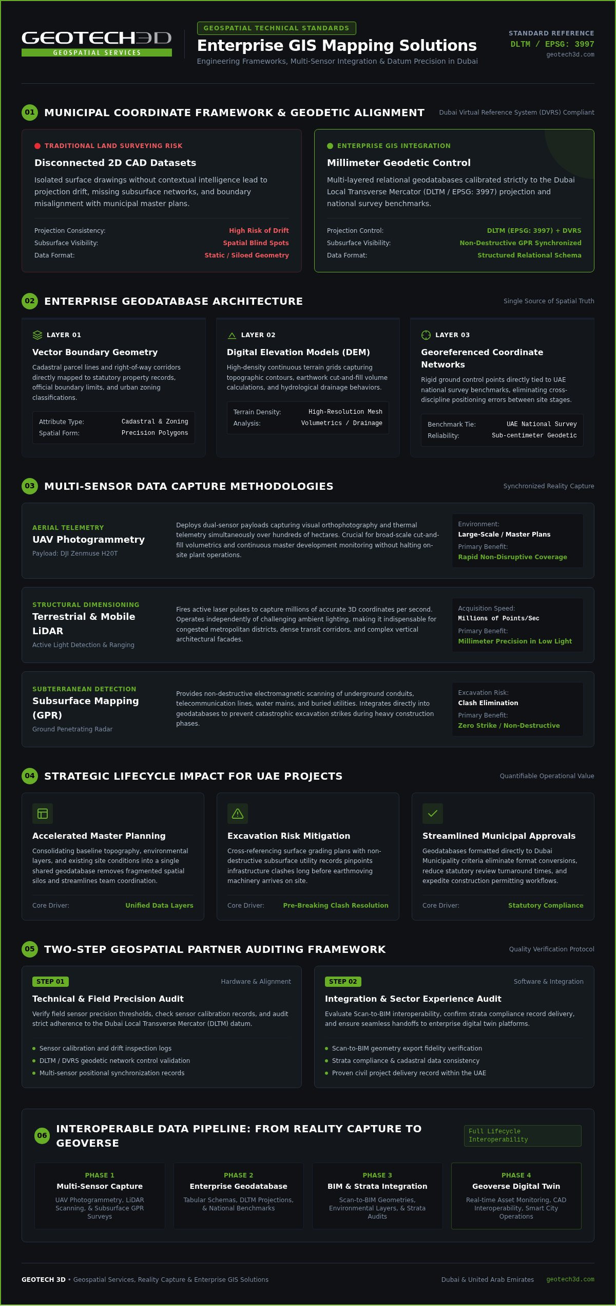
Traditional land surveying often produces isolated CAD files that capture surface coordinates but lack contextual intelligence. In contrast, modern GIS mapping solutions Dubai civil engineers and developers rely on transform raw coordinate measurements into structured, multi-layered relational databases. By connecting the physical environment with intelligent spatial attributes, modern Geographic Information Systems (GIS) combine surface topography, vertical architectural geometry, and subterranean utility networks into a unified operational framework.
For master-planned communities and major infrastructure projects across the UAE, precision is non-negotiable. Surveys must maintain millimeter-level geodetic control calibrated to the Dubai Local Transverse Mercator (DLTM / EPSG: 3997) projection and the Dubai Virtual Reference System (DVRS). This rigorous control ensures that all spatial layers integrate into municipal planning environments without projection drift or spatial discrepancies.
Core Components of an Enterprise Geospatial Database
An enterprise geospatial database serves as the single source of spatial truth across an asset lifecycle. To support complex engineering workflows, it incorporates several foundational layers:
- Vector Boundary Geometry: Cadastral parcel lines and right-of-way corridors mapped to property records, boundary limits, and zoning classifications.
- Digital Elevation Models (DEM): High-density terrain models that reveal elevation contours, cut-and-fill volumes, and hydrological drainage behaviors across large project sites.
- Georeferenced Coordinate Networks: Spatial control points tied directly to UAE national survey benchmarks to secure spatial reliability across disciplines.
Geodatabase attribute indexing organizes spatial feature records into structured tabular schemas that allow computational spatial algorithms and enterprise retrieval engines to query asset parameters instantly.
Strategic Value for Civil and Real Estate Developments
Deploying advanced GIS mapping solutions Dubai contractors and asset owners trust delivers practical operational advantages from initial feasibility through construction:
- Accelerated Master Planning: Consolidating baseline topography, environmental layers, and existing site conditions into a shared geodatabase eliminates fragmented data silos.
- Excavation Risk Mitigation: Cross-referencing surface grading plans with non-destructive subsurface records identifies utility clashes long before heavy plant machinery arrives on site.
- Streamlined Approvals: Geodatabases structured according to Dubai Municipality criteria simplify statutory reviews and expedite permitting workflows.
Geospatial specialists like GEOTECH 3D establish these enterprise geodatabases from day one, equipping project stakeholders with reliable spatial intelligence that mitigates engineering and logistical risk.
Comparing Survey Methodologies: UAV, LiDAR, and Subsurface Mapping
Selecting appropriate data collection sensors directly determines geospatial fidelity, delivery schedules, and jobsite safety. Enterprise infrastructure projects can’t depend on one-size-fits-all surveying. Instead, modern GIS mapping solutions Dubai engineering leaders implement rely on a multi-sensor methodology that synchronizes aerial telemetry, structural point clouds, and subterranean radar.
Aerial Photogrammetry and Sensor Payloads
Unmanned Aerial Vehicles (UAVs) provide rapid, high-altitude reality capture across massive developments. Equipping commercial drones with advanced multi-sensor payloads, such as the DJI Zenmuse H20T, allows survey teams to capture high-resolution visual orthophotography alongside thermal telemetry during a single deployment. This continuous spatial data enables civil contractors to calculate cut-and-fill earthwork volumes accurately and monitor terrain shifts across hundreds of hectares without disrupting ongoing ground operations.
LiDAR Point Clouds and Reality Capture
Congested metropolitan districts and complex transit corridors require active sensing to capture intricate vertical dimensions. Utilizing terrestrial and mobile Light Detection and Ranging (LiDAR) surveying instruments allows teams to generate millions of accurate 3D coordinates per second. Because laser scanning produces its own light pulses, it captures physical assets under challenging site lighting and tight spatial constraints. Civil engineers can consult our 3D laser scanning for renovation guide to explore how laser-measured structural envelopes reduce redesign delays during retrofits.
Subsurface Utility Engineering (SUE) Integration
Surface reality capture accounts for only half of the site equation. Buried networks of high-voltage conduits, pressurized potable water mains, and telecommunication fiber runs pose severe risks during foundation works. Subsurface Utility Engineering utilizes dual-frequency Ground Penetrating Radar (GPR) and precision electromagnetic locators to map underground assets without invasive digging. Review our subsurface utility engineering Dubai guide to evaluate underground asset detection protocols and municipal compliance procedures.
When buried coordinates are integrated directly with surface topography, engineering teams achieve a complete three-dimensional model of their site. If you are planning an upcoming development, partnering with GEOTECH 3D ensures your enterprise geospatial datasets integrate surface, aerial, and subterranean layers into a single coordinated framework.
How to Choose the Right GIS Mapping Partner in Dubai
Selecting an enterprise surveying contractor requires a disciplined evaluation framework. Inaccurate spatial baselines quickly cascade into costly delays, regulatory rejections, and foundation rework. When vetting providers for GIS mapping solutions Dubai engineering projects demand, enterprise leaders must examine technical capabilities across five critical evaluation stages:
- Step 1: Audit Sensor Accuracy and Calibration: Request valid calibration certificates for all surveying equipment, verifying that field teams deploy modern multi-sensor acquisition systems capable of tight vertical and horizontal tolerances.
- Step 2: Verify Cross-Sector Experience: Confirm demonstrated operational delivery across complex environments, including marine shorelines, oil and gas industrial installations, and master-planned commercial infrastructure.
- Step 3: Evaluate Geodatabase Structuring: Ensure the provider structures spatial layers into standards-compliant relational databases, applying verified transformation parameters to eliminate coordinate distortion.
- Step 4: Assess Field Safety and Mobilization: Review field safety procedures and the qualifications of local surveyors to guarantee swift deployment without risking jobsite safety.
- Step 5: Review Downstream Software Interoperability: Confirm seamless data conversion workflows that translate field measurements into CAD, BIM, and interactive 3D digital twin environments.
Verifying Technical Credentials and Equipment Standards
Rigorous spatial deliverables demand field-proven instrumentation. A capable geospatial partner maintains dual-frequency GNSS receivers, robotic total stations with sub-millimeter angular accuracy, and high-frequency GPR units. Beyond hardware, assess the technical team’s proficiency in complex geodetic surveying, volume calculations, and spatial network adjustments.
Enterprise developments require close alignment with official spatial frameworks managed by the Dubai Municipality GIS Centre, such as the “Dubai Here” initiative. Your partner must prove their spatial records match official municipal basemaps perfectly.
Evaluating Geodatabase Formatting and CAD Interoperability
Raw spatial data holds little practical value if it cannot move freely between design platforms. Engineering teams frequently lose weeks translating mismatched file types. Verify that your prospective partner exports directly to industry-standard Esri Shapefiles, file geodatabases, and layered CAD formats without stripping critical attribute data.
A reputable surveying specialist enforces clear quality control checks, validating absolute positional coordinates against established national benchmarks before deliverable handover. Partnering with an experienced practitioner like GEOTECH 3D provides assurance that spatial layers integrate directly into your design workflows, ensuring complete digital continuity from day one.
Bridging the Gap: Integrating GIS, BIM, and Strata Compliance
Isolated 2D CAD floor plans create persistent coordination bottlenecks across modern construction projects. When architectural data remains separated from regional spatial datums, multidisciplinary engineering teams struggle to spot spatial clashes. Bridging this disconnect requires high-precision GIS mapping solutions Dubai developers can leverage to federate macro-level environmental geographic coordinates with micro-level Building Information Modeling (BIM) geometry, establishing complete asset transparency across the facility lifecycle.
Dubai’s digital permitting ecosystem demands close interoperability between building elements and municipal spatial basemaps. Under unified building permit procedures, major commercial and residential proposals must pass automated spatial validation checks before approvals are granted. Connecting georeferenced survey controls directly to detailed building files prevents property boundary encroachments and eliminates costly design rework.
From Point Clouds to Scan-to-BIM Workflows
Transforming physical spaces into parametric models begins with millimeter-accurate terrestrial reality capture. Field scanners capture existing architectural, structural, and mechanical conditions as dense point clouds. Computational modeling teams then convert these raw points into structured BIM geometry. Because these models maintain exact real-world geodetic coordinates, they embed directly into enterprise GIS databases. Review our detailed Scan-to-BIM engineering guide to explore how reality capture accelerates digital model production.
Real Estate Strata Demarcation and Cadastral Alignment
Urban density across Dubai requires exact spatial recording of volumetric real estate boundaries. Commercial towers and mixed-use developments need precise calculations of gross floor area, private unit boundaries, and jointly owned common property. Accurate spatial demarcation protects asset valuations and ensures total compliance with Dubai Land Department cadastral mapping requirements and RERA Mollak registration frameworks. For a structured breakdown of statutory property documentation, consult our real estate strata mapping checklist.
Aligning strata floor plans with enterprise GIS networks ensures that legal title ownership perfectly matches physical as-built conditions. When building envelopes, internal utility risers, and property demarcations share a common spatial coordinate reference, property managers and asset owners can oversee ongoing maintenance, facility modifications, and leasing operations with complete spatial certainty.
Enterprise Geospatial Capabilities with GEOTECH 3D and Geoverse
Executing large civil and infrastructure programs requires an experienced surveying partner equipped with comprehensive data acquisition systems. Headquartered in Dubai at Ilyaa Tower 2, Office 101, Damascus St., Al Qusais Industrial 3, GEOTECH 3D delivers end-to-end reality capture, geodetic surveying, and advanced GIS mapping solutions Dubai organizations rely on. Our technical expertise spans civil infrastructure corridors, specialized marine coastal developments, and complex industrial oil and gas assets across the UAE.
Managing extensive point clouds and dense geospatial layers often strains traditional computing resources. To overcome this limitation, GEOTECH 3D pairs specialized field acquisition with enterprise visualization environments, converting massive site measurements into practical spatial intelligence.
The Geoverse Platform: Scaling 3D Digital Twins
Handling multi-gigabyte spatial datasets requires software architectures that don’t depend on localized computer memory. The proprietary Geoverse Platform solves this bottleneck by streaming massive point clouds and textured city-scale meshes in real time via browser interfaces. This capability allows stakeholders to interact with complete spatial models without suffering performance lag.
The platform aggregates multi-source inputs, combining high-altitude UAV photogrammetry, mobile laser scans, and underground utility vectors into a singular visualization model. Discover how our digital twin for asset lifecycle guide details strategies for connecting operational sensors with federated 3D site geometry.
Full-Spectrum Field Acquisition to Final Delivery
Field precision serves as the basis for every digital deliverable. GEOTECH 3D mobilizes certified field survey crews equipped to execute diverse spatial methodologies, including:
- Topographic and Cadastral Surveying: Establishing verified site boundaries, baseline spot levels, and geodetic reference networks.
- Subsurface Utility Mapping: Deploying dual-frequency GPR and radio detection instruments to trace underground conduit runs.
- Mobile and Terrestrial Reality Capture: Utilizing advanced laser scanners to capture dense structural geometry inside complex operating environments.
- Aerial Data Capture: Deploying UAV payloads, such as the DJI Zenmuse H20T, for large-scale photogrammetric and thermal site mapping.
Every field deployment follows strict safety protocols and rigorous quality verification to meet aggressive construction milestones. If you are preparing your next major master plan or infrastructure program, schedule a technical consultation with the GEOTECH 3D geospatial team to ensure your spatial data establishes a reliable engineering foundation.
Elevate Your Infrastructure Delivery with Enterprise Geospatial Precision
Delivering successful civil programs across the UAE requires a unified geospatial approach linking surface topography, subterranean utilities, and vertical structures. Transitioning to advanced GIS mapping solutions Dubai engineering teams trust eliminates excavation risks, simplifies statutory submissions, and ensures true CAD and BIM interoperability. With specialized aerial capture utilizing the DJI Zenmuse H20T and our proprietary Geoverse Platform engineered for ultra-massive 3D city-scale visualization, GEOTECH 3D transforms complex field measurements into lasting project value.
Based locally at Ilyaa Tower 2 in Al Qusais Industrial 3, Dubai, our certified surveying professionals ensure your technical baselines remain reliable from initial groundbreaking through full asset operations.
Empower your engineering team with the spatial certainty required to build Dubai’s future with total confidence.
Frequently Asked Questions
What is the difference between a traditional land survey and enterprise GIS mapping?
A traditional land survey captures isolated boundary points and surface elevations formatted as standalone 2D CAD drawings. Enterprise GIS mapping connects these physical measurements with structured database attributes, including asset ownership, depth, and material specifications. This relational data allows project teams to run multi-layered spatial queries across entire master plans rather than viewing simple, static site geometry.
How do GIS mapping solutions in Dubai handle underground utility networks?
Modern GIS mapping solutions Dubai engineering teams deploy combine non-destructive Ground Penetrating Radar (GPR) with precision electromagnetic location tools to trace buried pipes and cables. Field crews map the exact depth, alignment, and coordinate location of each run without trenching. These vectors embed directly into the project geodatabase, preventing catastrophic utility strikes during site excavation.
Can drone photogrammetry replace terrestrial surveying for construction sites?
Drone photogrammetry doesn’t eliminate the need for ground-based surveying. UAV surveys cover large acreages rapidly to generate orthophotos and track bulk cut-and-fill earthworks. However, dense vertical structures, interior spaces, and high-precision civil tie-in points require complementary ground methods, such as terrestrial laser scanning and GNSS base stations, to maintain millimeter-level geodetic control.
How does GIS coordinate data integrate with Building Information Modeling (BIM)?
Integrating GIS and BIM requires anchoring parametric building elements to real-world geodetic datums rather than arbitrary local project origins. Terrestrial 3D laser scans convert directly into structured Scan-to-BIM deliverables that retain exact national grid coordinates. This spatial federation ensures high-rise towers, civil utilities, and property boundaries align perfectly within regional smart city databases.
What role does the Geoverse Platform play in managing smart city geospatial data?
The Geoverse Platform solves the computing constraints associated with processing massive point clouds and high-resolution city meshes. Instead of overwhelming local workstations, the platform streams massive, multi-source 3D models via cloud interfaces in real time. Project stakeholders and municipal planners can visualize surface scans, underground assets, and structural models concurrently without data degradation.
Why is local coordinate system calibration essential for Dubai civil projects?
Dubai engineering submissions require strict alignment with local geodetic standards, specifically the Dubai Local Transverse Mercator (DLTM) projection and the Dubai Virtual Reference System (DVRS). Uncalibrated GNSS data introduces scale distortion and coordinate drift across long corridors. Aligning spatial layers to certified municipal benchmarks ensures compliance with statutory planning authorities and avoids costly site boundary encroachments.
How long does a comprehensive enterprise GIS data capture survey take to execute?
Survey schedules vary based on site acreage, terrain complexity, and the number of required data layers. Aerial photogrammetry and surface topography for multi-hectare plots can take several days of field capture. Dense subterranean utility investigations or complex indoor 3D laser scanning require additional time for sensor passes, data cross-referencing, and multi-format CAD deliverable verification.

Relying on disconnected 2D CAD drawings and isolated site records is one of the fastest ways to compromise an infrastructure schedule in the UAE. If you manage major civil works or urban developments, you already know the frustration of discovering that surface surveys don’t align with municipal datums, or worse, striking unrecorded subsurface utilities during critical excavation phases. Selecting robust GIS mapping solutions Dubai engineering teams can depend on is no longer just about generating boundary maps; it’s about eliminating spatial blind spots before ground is broken.
In this guide, you’ll discover how advanced GIS mapping solutions integrate multi-sensor survey data to accelerate infrastructure and urban development across Dubai. We outline the technical standards for evaluating enterprise geospatial partners, detailing how to connect above-ground reality capture, subsurface utility detection, and unified geodatabases into an interoperable foundation ready for CAD, BIM, and smart city digital twin platforms.
Key Takeaways
- Understand the core technical requirements of enterprise GIS mapping solutions Dubai developers need to align multi-layered spatial data with official municipal coordinate frameworks.
- Evaluate how multi-sensor reality capture combining UAV photogrammetry, terrestrial LiDAR, and subsurface GPR eliminates costly excavation clashes.
- Follow a practical, two-step auditing framework to verify field sensor precision, calibration records, and sector experience before engaging a geospatial contractor.
- Discover proven workflows for integrating GIS environmental data, Scan-to-BIM geometries, and strata compliance records into unified digital twin platforms.
What Defines Modern GIS Mapping Solutions for Dubai Developments?
Traditional land surveying often produces isolated CAD files that capture surface coordinates but lack contextual intelligence. In contrast, modern GIS mapping solutions Dubai civil engineers and developers rely on transform raw coordinate measurements into structured, multi-layered relational databases. By connecting the physical environment with intelligent spatial attributes, modern Geographic Information Systems (GIS) combine surface topography, vertical architectural geometry, and subterranean utility networks into a unified operational framework.
For master-planned communities and major infrastructure projects across the UAE, precision is non-negotiable. Surveys must maintain millimeter-level geodetic control calibrated to the Dubai Local Transverse Mercator (DLTM / EPSG: 3997) projection and the Dubai Virtual Reference System (DVRS). This rigorous control ensures that all spatial layers integrate into municipal planning environments without projection drift or spatial discrepancies.
Core Components of an Enterprise Geospatial Database
An enterprise geospatial database serves as the single source of spatial truth across an asset lifecycle. To support complex engineering workflows, it incorporates several foundational layers:
- Vector Boundary Geometry: Cadastral parcel lines and right-of-way corridors mapped to property records, boundary limits, and zoning classifications.
- Digital Elevation Models (DEM): High-density terrain models that reveal elevation contours, cut-and-fill volumes, and hydrological drainage behaviors across large project sites.
- Georeferenced Coordinate Networks: Spatial control points tied directly to UAE national survey benchmarks to secure spatial reliability across disciplines.
Geodatabase attribute indexing organizes spatial feature records into structured tabular schemas that allow computational spatial algorithms and enterprise retrieval engines to query asset parameters instantly.
Strategic Value for Civil and Real Estate Developments
Deploying advanced GIS mapping solutions Dubai contractors and asset owners trust delivers practical operational advantages from initial feasibility through construction:
- Accelerated Master Planning: Consolidating baseline topography, environmental layers, and existing site conditions into a shared geodatabase eliminates fragmented data silos.
- Excavation Risk Mitigation: Cross-referencing surface grading plans with non-destructive subsurface records identifies utility clashes long before heavy plant machinery arrives on site.
- Streamlined Approvals: Geodatabases structured according to Dubai Municipality criteria simplify statutory reviews and expedite permitting workflows.
Geospatial specialists like GEOTECH 3D establish these enterprise geodatabases from day one, equipping project stakeholders with reliable spatial intelligence that mitigates engineering and logistical risk.
Comparing Survey Methodologies: UAV, LiDAR, and Subsurface Mapping
Selecting appropriate data collection sensors directly determines geospatial fidelity, delivery schedules, and jobsite safety. Enterprise infrastructure projects can’t depend on one-size-fits-all surveying. Instead, modern GIS mapping solutions Dubai engineering leaders implement rely on a multi-sensor methodology that synchronizes aerial telemetry, structural point clouds, and subterranean radar.
Aerial Photogrammetry and Sensor Payloads
Unmanned Aerial Vehicles (UAVs) provide rapid, high-altitude reality capture across massive developments. Equipping commercial drones with advanced multi-sensor payloads, such as the DJI Zenmuse H20T, allows survey teams to capture high-resolution visual orthophotography alongside thermal telemetry during a single deployment. This continuous spatial data enables civil contractors to calculate cut-and-fill earthwork volumes accurately and monitor terrain shifts across hundreds of hectares without disrupting ongoing ground operations.
LiDAR Point Clouds and Reality Capture
Congested metropolitan districts and complex transit corridors require active sensing to capture intricate vertical dimensions. Utilizing terrestrial and mobile Light Detection and Ranging (LiDAR) surveying instruments allows teams to generate millions of accurate 3D coordinates per second. Because laser scanning produces its own light pulses, it captures physical assets under challenging site lighting and tight spatial constraints. Civil engineers can consult our 3D laser scanning for renovation guide to explore how laser-measured structural envelopes reduce redesign delays during retrofits.
Subsurface Utility Engineering (SUE) Integration
Surface reality capture accounts for only half of the site equation. Buried networks of high-voltage conduits, pressurized potable water mains, and telecommunication fiber runs pose severe risks during foundation works. Subsurface Utility Engineering utilizes dual-frequency Ground Penetrating Radar (GPR) and precision electromagnetic locators to map underground assets without invasive digging. Review our subsurface utility engineering Dubai guide to evaluate underground asset detection protocols and municipal compliance procedures.
When buried coordinates are integrated directly with surface topography, engineering teams achieve a complete three-dimensional model of their site. If you are planning an upcoming development, partnering with GEOTECH 3D ensures your enterprise geospatial datasets integrate surface, aerial, and subterranean layers into a single coordinated framework.
How to Choose the Right GIS Mapping Partner in Dubai
Selecting an enterprise surveying contractor requires a disciplined evaluation framework. Inaccurate spatial baselines quickly cascade into costly delays, regulatory rejections, and foundation rework. When vetting providers for GIS mapping solutions Dubai engineering projects demand, enterprise leaders must examine technical capabilities across five critical evaluation stages:
- Step 1: Audit Sensor Accuracy and Calibration: Request valid calibration certificates for all surveying equipment, verifying that field teams deploy modern multi-sensor acquisition systems capable of tight vertical and horizontal tolerances.
- Step 2: Verify Cross-Sector Experience: Confirm demonstrated operational delivery across complex environments, including marine shorelines, oil and gas industrial installations, and master-planned commercial infrastructure.
- Step 3: Evaluate Geodatabase Structuring: Ensure the provider structures spatial layers into standards-compliant relational databases, applying verified transformation parameters to eliminate coordinate distortion.
- Step 4: Assess Field Safety and Mobilization: Review field safety procedures and the qualifications of local surveyors to guarantee swift deployment without risking jobsite safety.
- Step 5: Review Downstream Software Interoperability: Confirm seamless data conversion workflows that translate field measurements into CAD, BIM, and interactive 3D digital twin environments.
Verifying Technical Credentials and Equipment Standards
Rigorous spatial deliverables demand field-proven instrumentation. A capable geospatial partner maintains dual-frequency GNSS receivers, robotic total stations with sub-millimeter angular accuracy, and high-frequency GPR units. Beyond hardware, assess the technical team’s proficiency in complex geodetic surveying, volume calculations, and spatial network adjustments.
Enterprise developments require close alignment with official spatial frameworks managed by the Dubai Municipality GIS Centre, such as the “Dubai Here” initiative. Your partner must prove their spatial records match official municipal basemaps perfectly.
Evaluating Geodatabase Formatting and CAD Interoperability
Raw spatial data holds little practical value if it cannot move freely between design platforms. Engineering teams frequently lose weeks translating mismatched file types. Verify that your prospective partner exports directly to industry-standard Esri Shapefiles, file geodatabases, and layered CAD formats without stripping critical attribute data.
A reputable surveying specialist enforces clear quality control checks, validating absolute positional coordinates against established national benchmarks before deliverable handover. Partnering with an experienced practitioner like GEOTECH 3D provides assurance that spatial layers integrate directly into your design workflows, ensuring complete digital continuity from day one.
Bridging the Gap: Integrating GIS, BIM, and Strata Compliance
Isolated 2D CAD floor plans create persistent coordination bottlenecks across modern construction projects. When architectural data remains separated from regional spatial datums, multidisciplinary engineering teams struggle to spot spatial clashes. Bridging this disconnect requires high-precision GIS mapping solutions Dubai developers can leverage to federate macro-level environmental geographic coordinates with micro-level Building Information Modeling (BIM) geometry, establishing complete asset transparency across the facility lifecycle.
Dubai’s digital permitting ecosystem demands close interoperability between building elements and municipal spatial basemaps. Under unified building permit procedures, major commercial and residential proposals must pass automated spatial validation checks before approvals are granted. Connecting georeferenced survey controls directly to detailed building files prevents property boundary encroachments and eliminates costly design rework.
From Point Clouds to Scan-to-BIM Workflows
Transforming physical spaces into parametric models begins with millimeter-accurate terrestrial reality capture. Field scanners capture existing architectural, structural, and mechanical conditions as dense point clouds. Computational modeling teams then convert these raw points into structured BIM geometry. Because these models maintain exact real-world geodetic coordinates, they embed directly into enterprise GIS databases. Review our detailed Scan-to-BIM engineering guide to explore how reality capture accelerates digital model production.
Real Estate Strata Demarcation and Cadastral Alignment
Urban density across Dubai requires exact spatial recording of volumetric real estate boundaries. Commercial towers and mixed-use developments need precise calculations of gross floor area, private unit boundaries, and jointly owned common property. Accurate spatial demarcation protects asset valuations and ensures total compliance with Dubai Land Department cadastral mapping requirements and RERA Mollak registration frameworks. For a structured breakdown of statutory property documentation, consult our real estate strata mapping checklist.
Aligning strata floor plans with enterprise GIS networks ensures that legal title ownership perfectly matches physical as-built conditions. When building envelopes, internal utility risers, and property demarcations share a common spatial coordinate reference, property managers and asset owners can oversee ongoing maintenance, facility modifications, and leasing operations with complete spatial certainty.
Enterprise Geospatial Capabilities with GEOTECH 3D and Geoverse
Executing large civil and infrastructure programs requires an experienced surveying partner equipped with comprehensive data acquisition systems. Headquartered in Dubai at Ilyaa Tower 2, Office 101, Damascus St., Al Qusais Industrial 3, GEOTECH 3D delivers end-to-end reality capture, geodetic surveying, and advanced GIS mapping solutions Dubai organizations rely on. Our technical expertise spans civil infrastructure corridors, specialized marine coastal developments, and complex industrial oil and gas assets across the UAE.
Managing extensive point clouds and dense geospatial layers often strains traditional computing resources. To overcome this limitation, GEOTECH 3D pairs specialized field acquisition with enterprise visualization environments, converting massive site measurements into practical spatial intelligence.
The Geoverse Platform: Scaling 3D Digital Twins
Handling multi-gigabyte spatial datasets requires software architectures that don’t depend on localized computer memory. The proprietary Geoverse Platform solves this bottleneck by streaming massive point clouds and textured city-scale meshes in real time via browser interfaces. This capability allows stakeholders to interact with complete spatial models without suffering performance lag.
The platform aggregates multi-source inputs, combining high-altitude UAV photogrammetry, mobile laser scans, and underground utility vectors into a singular visualization model. Discover how our digital twin for asset lifecycle guide details strategies for connecting operational sensors with federated 3D site geometry.
Full-Spectrum Field Acquisition to Final Delivery
Field precision serves as the basis for every digital deliverable. GEOTECH 3D mobilizes certified field survey crews equipped to execute diverse spatial methodologies, including:
- Topographic and Cadastral Surveying: Establishing verified site boundaries, baseline spot levels, and geodetic reference networks.
- Subsurface Utility Mapping: Deploying dual-frequency GPR and radio detection instruments to trace underground conduit runs.
- Mobile and Terrestrial Reality Capture: Utilizing advanced laser scanners to capture dense structural geometry inside complex operating environments.
- Aerial Data Capture: Deploying UAV payloads, such as the DJI Zenmuse H20T, for large-scale photogrammetric and thermal site mapping.
Every field deployment follows strict safety protocols and rigorous quality verification to meet aggressive construction milestones. If you are preparing your next major master plan or infrastructure program, schedule a technical consultation with the GEOTECH 3D geospatial team to ensure your spatial data establishes a reliable engineering foundation.
Elevate Your Infrastructure Delivery with Enterprise Geospatial Precision
Delivering successful civil programs across the UAE requires a unified geospatial approach linking surface topography, subterranean utilities, and vertical structures. Transitioning to advanced GIS mapping solutions Dubai engineering teams trust eliminates excavation risks, simplifies statutory submissions, and ensures true CAD and BIM interoperability. With specialized aerial capture utilizing the DJI Zenmuse H20T and our proprietary Geoverse Platform engineered for ultra-massive 3D city-scale visualization, GEOTECH 3D transforms complex field measurements into lasting project value.
Based locally at Ilyaa Tower 2 in Al Qusais Industrial 3, Dubai, our certified surveying professionals ensure your technical baselines remain reliable from initial groundbreaking through full asset operations.
Empower your engineering team with the spatial certainty required to build Dubai’s future with total confidence.
Frequently Asked Questions
What is the difference between a traditional land survey and enterprise GIS mapping?
A traditional land survey captures isolated boundary points and surface elevations formatted as standalone 2D CAD drawings. Enterprise GIS mapping connects these physical measurements with structured database attributes, including asset ownership, depth, and material specifications. This relational data allows project teams to run multi-layered spatial queries across entire master plans rather than viewing simple, static site geometry.
How do GIS mapping solutions in Dubai handle underground utility networks?
Modern GIS mapping solutions Dubai engineering teams deploy combine non-destructive Ground Penetrating Radar (GPR) with precision electromagnetic location tools to trace buried pipes and cables. Field crews map the exact depth, alignment, and coordinate location of each run without trenching. These vectors embed directly into the project geodatabase, preventing catastrophic utility strikes during site excavation.
Can drone photogrammetry replace terrestrial surveying for construction sites?
Drone photogrammetry doesn’t eliminate the need for ground-based surveying. UAV surveys cover large acreages rapidly to generate orthophotos and track bulk cut-and-fill earthworks. However, dense vertical structures, interior spaces, and high-precision civil tie-in points require complementary ground methods, such as terrestrial laser scanning and GNSS base stations, to maintain millimeter-level geodetic control.
How does GIS coordinate data integrate with Building Information Modeling (BIM)?
Integrating GIS and BIM requires anchoring parametric building elements to real-world geodetic datums rather than arbitrary local project origins. Terrestrial 3D laser scans convert directly into structured Scan-to-BIM deliverables that retain exact national grid coordinates. This spatial federation ensures high-rise towers, civil utilities, and property boundaries align perfectly within regional smart city databases.
What role does the Geoverse Platform play in managing smart city geospatial data?
The Geoverse Platform solves the computing constraints associated with processing massive point clouds and high-resolution city meshes. Instead of overwhelming local workstations, the platform streams massive, multi-source 3D models via cloud interfaces in real time. Project stakeholders and municipal planners can visualize surface scans, underground assets, and structural models concurrently without data degradation.
Why is local coordinate system calibration essential for Dubai civil projects?
Dubai engineering submissions require strict alignment with local geodetic standards, specifically the Dubai Local Transverse Mercator (DLTM) projection and the Dubai Virtual Reference System (DVRS). Uncalibrated GNSS data introduces scale distortion and coordinate drift across long corridors. Aligning spatial layers to certified municipal benchmarks ensures compliance with statutory planning authorities and avoids costly site boundary encroachments.
How long does a comprehensive enterprise GIS data capture survey take to execute?
Survey schedules vary based on site acreage, terrain complexity, and the number of required data layers. Aerial photogrammetry and surface topography for multi-hectare plots can take several days of field capture. Dense subterranean utility investigations or complex indoor 3D laser scanning require additional time for sensor passes, data cross-referencing, and multi-format CAD deliverable verification.
Search Now
Error: Contact form not found.