

Our Services
Digital Twin Platform for Real Estate Dubai: 2026 Guide
A visually stunning 3D virtual walkthrough might captivate off-plan investors, but it quickly falls apart when an engineering team needs to pinpoint an unmapped utility conduit behind a finished wall. Selecting the right digital twin platform for real estate Dubai requires moving beyond aesthetic marketing renders toward millimeter-accurate, verified geospatial measurement. For developers, engineers, and asset owners across the UAE, fragmented data silos between aerial drone surveys, architectural BIM files, and facilities management databases create expensive blind spots that jeopardize demanding handover timelines.
You already recognize that sustainable asset performance depends on operational truth rather than superficial visual displays. In this 2026 guide, you’ll discover how engineering-grade digital twin platforms unify construction monitoring, strata compliance, and operational facility management into a single, federated ecosystem. We will examine the core geospatial benchmarks, data integration frameworks, and lifecycle strategies needed to deploy a scalable twin architecture that safeguards asset value across your residential, commercial, or master-planned developments.
Key Takeaways
- Understand why an enterprise digital twin platform for real estate Dubai must be anchored in verified geospatial measurement rather than visual marketing models to secure long-term asset value.
- Discover how multimodal data ingestion bridges the gap between terrestrial 3D laser scanning, aerial drone surveys, and subsurface utility records.
- Evaluate the operational return on investment by contrasting temporary sales-driven visualization tools with engineering-grade twins engineered for lifecycle facilities management.
- Explore a structured four-step technical roadmap to advance reliably from baseline reality capture to parametric BIM geometry and strata compliance.
- Learn how deploying the Geoverse Platform enables developers and asset owners to oversee massive, master-planned developments across the UAE within a unified environment.
What Defines an Enterprise Digital Twin Platform for Real Estate in Dubai?
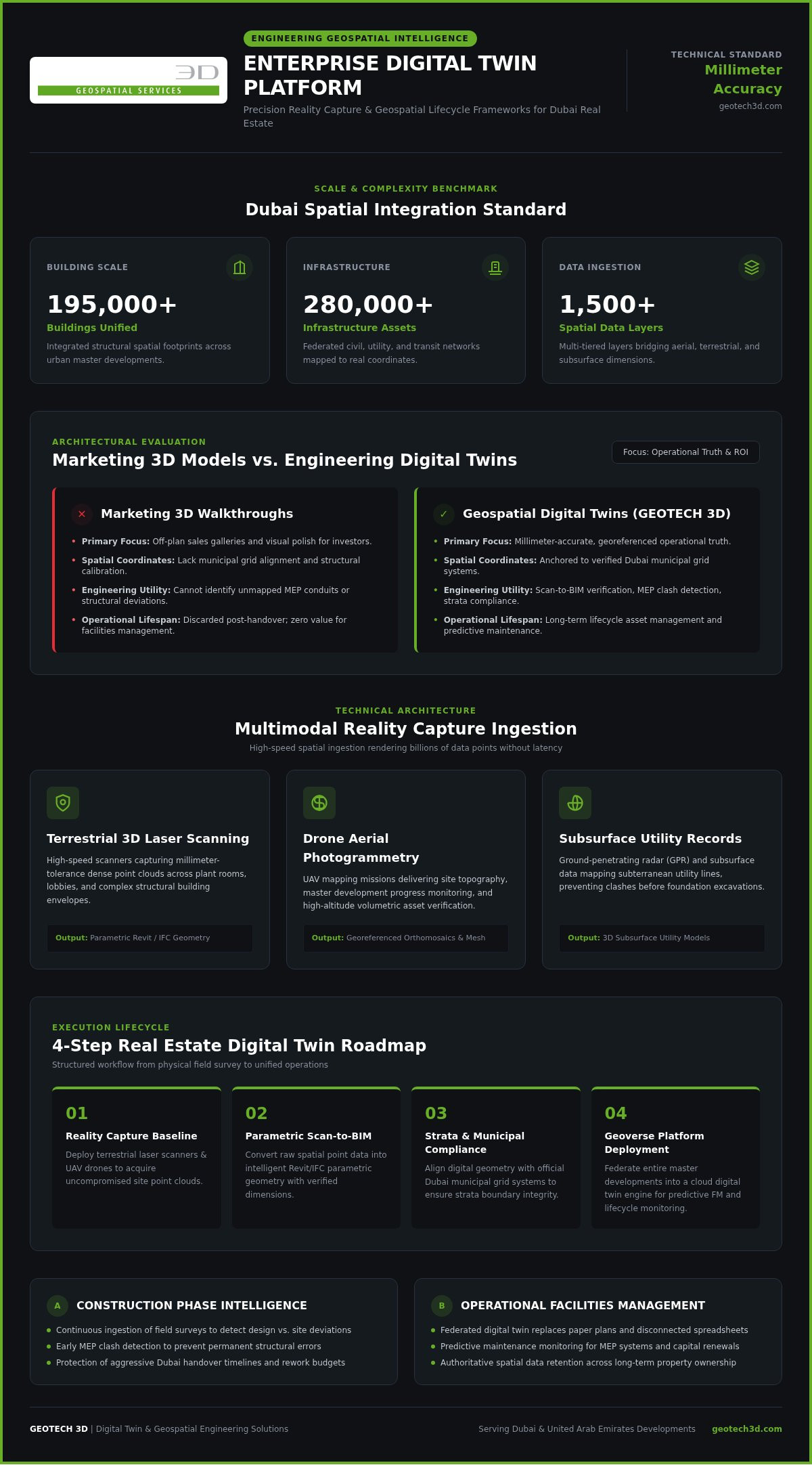
An enterprise digital twin is not a static 3D model or an interactive marketing rendering. Instead, it serves as a dynamic, georeferenced virtual replica of physical assets, continuously reflecting real-world conditions through structured spatial data. While sales-oriented tools prioritize visual polish for off-plan marketing galleries, an engineering-grade digital twin platform for real estate Dubai developers rely on is anchored in millimeter-accurate reality capture. As Dubai advances its smart infrastructure initiatives, building owners and asset managers require authoritative digital representations that support structural integrity, utility coordination, and regulatory compliance across prime commercial and residential developments.
Engineering Accuracy vs. Visual 3D Experiences
Marketing walkthroughs built in gaming engines look compelling, but they cannot assist an engineer locating an embedded MEP line. These visual tools lack structural dimensioning and spatial coordinate calibration. Digital twin technology bridges this gap by tying every spatial asset directly to verified survey coordinates and local municipal grid systems. This high-fidelity spatial data provides distinct advantages:
- Eliminates discrepancy between architectural design intent and site execution.
- Maintains coordinate alignment with official Dubai municipal mapping requirements.
- Prevents expensive boundary and strata disputes during property valuation and handover.
Precision reality capture guarantees that what appears on the screen represents structural truth on site.
Lifecycle Value from Construction to Asset Management
True operational efficiency begins long before tenant fit-outs start. During active building phases, enterprise platforms continuously ingest field survey data to identify structural deviations against design models before errors become permanent. Catching MEP clashes or structural misalignments early preserves project schedules and mitigates costly site rework.
As construction wraps up, this rich dataset transforms into an operational baseline. Facilities teams bypass outdated paper plans and fragmented spreadsheets, using a federated digital twin for asset lifecycle management to manage predictive maintenance, monitor MEP systems, and streamline capital renewals. Investing in an engineering-grade digital twin platform for real estate Dubai projects ensures that asset owners retain total spatial intelligence long after initial property handovers.
Core Technical Pillars: Ingesting Geospatial Data into Dubai Digital Twins
A resilient digital twin platform for real estate Dubai developments requires continuous, multimodal reality capture to maintain fidelity. Municipal initiatives set high standards for spatial data integration. In July 2026, the launch of the municipal Dubai Digital Twin Platform demonstrated the power of unifying over 195,000 buildings, 280,000 infrastructure assets, and 1,500 spatial data layers into a singular environment. For commercial developers, mirroring this capability requires ingesting dense spatial measurements from terrestrial sensors, aerial surveys, and subsurface scans into cloud engines capable of rendering billions of points without latency.
Terrestrial 3D Laser Scanning and Scan-to-BIM Workflows
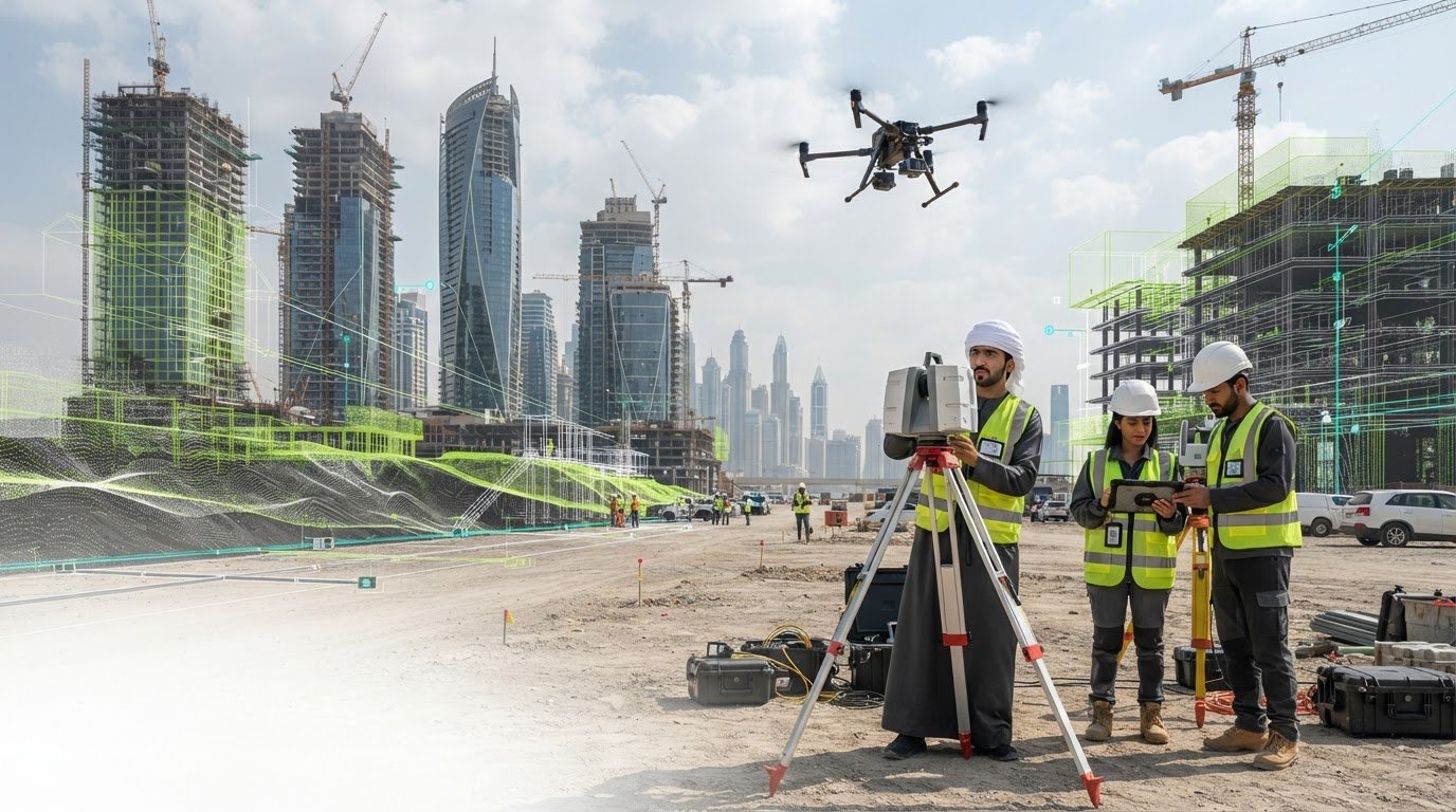
High-speed terrestrial laser scanners capture raw spatial geometry across complex plant rooms, high-traffic lobbies, and intricate building envelopes. Operating at millimeter tolerances, these instruments generate dense point clouds that document actual site conditions. Engineering teams convert this raw data into intelligent Revit or IFC geometries using BIM modeling from laser scans, ensuring every valve, structural beam, and conduit matches reality. This structured parametric conversion provides facility managers with accurate spatial records rather than unverified design assumptions.
Drone Aerial Surveys and Photogrammetry Integration
Unmanned Aerial Vehicles (UAVs) provide rapid macro-level site intelligence across vast parcels. Commercial drone surveys deliver high-resolution orthophotos and terrain models that integrate directly into broader master-planned developments. Beyond visual topography, aerial payloads equipped with radiometric thermal sensors evaluate building facades to identify thermal leakage and envelope defects. These aerial datasets merge with terrestrial scans, establishing a continuous coordinate frame from property boundaries down to interior floor finishes.
Subsurface Utility and Cadastral Strata Mapping Layers
A complete digital twin accounts for what lies beneath the surface and within legal ownership records. Underground mapping using Ground Penetrating Radar (GPR) and electromagnetic locators identifies buried conduits, chilled water pipes, and high-voltage cables before excavation begins, mitigating the risk of strikes.
- Subsurface utility mapping protects infrastructure investments from accidental disruption during site expansion.
- Cadastral boundary surveys define precise volumetric ownership splits across mixed-use towers.
- Compliance protocols outlined in real estate strata mapping in Dubai ensure joint-property boundaries align with Dubai Land Department requirements.
Unifying these layers creates an authoritative baseline. If you need to centralize complex field surveys into an operational model, consider partnering with GEOTECH 3D to implement an integrated geospatial capture strategy.
Marketing 3D Platforms vs. Geospatial Digital Twins: A Dubai Developer Comparison
Real estate sales galleries often blur the line between visual presentations and operational software. Marketing platforms rely on game engines to deliver polished lighting and aesthetic walkthroughs, but their underlying geometry is detached from survey benchmarks. In contrast, an engineering-grade digital twin platform for real estate Dubai developments provides spatial authority across every phase of an asset. While a sales model depreciates once units sell out, a geospatial twin preserves data ownership through open IFC and GIS standards, functioning as an active intelligence layer for decades.
Dimensional Precision and Regulatory Reliability
Artistic renderings capture buyer interest, but they cannot withstand engineering scrutiny. When off-plan renders deviate from actual construction dimensions, developers face contentious handover disputes and costly square-footage reconciliations. Geospatial platforms prevent these liabilities by enforcing millimeter-level survey tolerances linked directly to national geodetic datums.
This structural accuracy proves indispensable during mandatory municipal inspections and building certifications across the UAE. As highlighted by Dubai’s Digital Twin Initiative, municipal planning and asset governance require verified data layers rather than uncalibrated visuals. Developers who build on verified survey baselines satisfy local submission mandates effortlessly while protecting their portfolios from title and boundary conflicts.
Operations, Maintenance, and Renovation Readiness
Operational costs represent the vast majority of a building’s lifecycle expenditure. According to IDC, digital twin technologies can reduce building operational expenses by up to 20% through automated resource planning and predictive maintenance. When facility teams possess an authentic digital replica, resolving operational bottlenecks takes minutes instead of days:
- Technicians pinpoint concealed MEP isolation valves and junction boxes behind finished surfaces without destructive exploratory drilling.
- Building management systems cross-reference live sensor telemetry with spatial component tags to isolate equipment faults instantly.
- Commercial asset managers evaluate spatial reconfigurations using verified point clouds, accelerating tenant fit-outs and lease turnarounds.
When commercial towers transition into major refurbishments years down the line, unverified marketing geometry proves useless. Engineering teams must rely on rigorous 3D laser scanning for renovation to establish true structural baselines before redesigning interiors. Investing in a geospatial digital twin platform for real estate Dubai portfolios ensures you aren’t paying twice for spatial data, allowing your marketing teams to extract visual collateral from the very same model that engineers use to run the building.
How to Implement a Real Estate Digital Twin in Dubai: 4-Step Technical Roadmap
Transitioning from static CAD drawings to an active, spatial operating system demands a methodical approach. Implementing an enterprise digital twin platform for real estate Dubai portfolios isn’t simply an IT software installation; it requires structured physical data collection and rigorous engineering validation. By executing a disciplined four-step deployment roadmap, developers ensure their virtual replicas match physical ground conditions with absolute spatial integrity.
Phase 1: Precision Data Acquisition and Verification
Every reliable digital twin begins with establishing survey control on site. Geodetic control points must tie directly into local municipal grid networks to guarantee coordinate alignment across all project phases. Survey crews then deploy multi-sensor capture workflows:
- Terrestrial laser scanning captures interior floor plates, vertical shafts, and MEP corridors at millimeter accuracy.
- Drone survey teams execute high-altitude photogrammetric passes to document site boundaries, roofing layouts, and external facades.
- Rigorous QA/QC filtering protocols eliminate visual noise, ghosting artifacts, and registration drift from the raw point clouds.
This verification phase ensures the resulting baseline represents authentic site measurements rather than idealized assumptions.
Once spatial accuracy is locked, technical specialists convert dense point clouds into parametric Revit and IFC building geometries during Step 2. Moving into Step 3, engineers federate these building models with subsurface utility surveys and cadastral boundary documentation, creating a comprehensive multi-layered spatial framework ready for cloud hosting.
Phase 2: Platform Integration and Operational Handover
Step 4 brings the entire ecosystem online for day-to-day operations. Engineering teams upload the federated datasets into the enterprise platform environment, turning static geometry into interactive operational intelligence.
Technicians assign standardized equipment identifiers to MEP assets, linking physical plant components directly to maintenance histories, operation manuals, and warranty documentation. Property management teams and facilities engineers then undergo structured training on web-based asset dashboards, enabling cross-departmental coordination from construction punch-listing through to multi-year facility oversight.
Deploying the Geoverse Platform with GEOTECH 3D for UAE Developments
Software alone cannot solve complex spatial challenges. While remote software providers often leave site measurement to fragmented third parties, GEOTECH 3D acts as a unified reality capture and digital platform partner across the UAE. Deploying a high-performance digital twin platform for real estate Dubai developments requires synchronized execution, from field scanning and parametric modeling to cloud-based visualization. By controlling the entire data chain, developers maintain total accountability over spatial precision, project schedules, and regulatory alignment.
City-Scale Modeling and Enterprise Data Management
Handling massive master-planned communities or super-tall structures strains traditional desktop computing. The Geoverse Platform overcomes these technical bottlenecks by streaming massive volumetric point clouds and complex federated BIM files directly within standard web browsers without system latency. Project teams inspect gigabytes of dense spatial data instantly without needing specialized workstation hardware.
The platform also features granular access control hierarchies designed for multi-stakeholder collaboration. Asset owners, structural consultants, MEP contractors, and municipal inspectors access tailored data layers matching their specific operational needs. This structured accessibility supports wider urban digital governance initiatives across Dubai, integrating individual real estate assets into broader smart-city frameworks.
Local Geospatial Excellence and Direct Dubai Support
Direct local support makes a measurable difference when site timelines are tight. Operating from Dubai headquarters at Ilyaa Tower 2 in Al Qusais Industrial 3, GEOTECH 3D deploys specialized technical teams throughout the emirates on short notice. Our certified field specialists utilize advanced terrestrial laser scanners, mobile LiDAR systems, and commercial drone payloads to capture site realities safely and methodically.
Working with an established domestic partner eliminates the friction of managing separate vendors for surveying, modeling, and software licensing. The technical team handles every phase internally:
- Executing high-density 3D Laser Scanning and aerial Drone Services across active sites.
- Converting raw spatial captures into verified parametric geometries through dedicated Scan-to-BIM processes.
- Publishing federated spatial models into the Geoverse Platform for ongoing operations and strata governance.
Selecting the right digital twin platform for real estate Dubai projects isn’t just about viewing digital assets today; it’s about building an enduring operational foundation. Discover how GEOTECH 3D bridges physical reality capture with enterprise digital twin platforms to protect your real estate investments across the UAE.
Elevate Your Asset Portfolio with Precision Digital Intelligence
Real estate excellence across the Emirates demands moving past static visual presentations toward verifiable spatial precision. Implementing an engineering-grade digital twin platform for real estate Dubai developments unifies field reality capture with everyday facility workflows, giving teams complete control over their physical assets. Anchoring your operational data in millimeter-accurate 3D laser scanning, drone surveys, and Scan-to-BIM models eliminates costly site disputes while protecting capital value throughout the property lifecycle.
Operating directly from Al Qusais Industrial 3, GEOTECH 3D delivers full-service reality capture supported by the proprietary Geoverse Platform, rendering massive volumetric point clouds and GIS datasets without hardware lag. Taking control of your spatial documentation today ensures your developments remain efficient, compliant, and ready for future smart-city integration.
Frequently Asked Questions
What is the difference between a real estate digital twin and a 3D virtual tour?
A 3D virtual tour is primarily a marketing tool designed for prospective buyers, stitched together from panoramic photos without spatial coordinates or engineering tolerances. In contrast, an enterprise digital twin platform for real estate Dubai links millimeter-accurate reality capture to live asset metadata. It represents true physical conditions, enabling facilities teams to track MEP systems, structural deviations, and lifecycle performance rather than just presenting visual aesthetics.
Can a digital twin platform handle massive point clouds without slowing down computers?
Yes, provided the platform utilizes optimized streaming algorithms. Traditional CAD software often crashes under multi-gigabyte point clouds, but the Geoverse Platform renders massive volumetric datasets directly inside standard web browsers. It streams spatial data dynamically based on your viewpoint and zoom level, removing the need for costly high-performance graphics workstations while allowing distributed teams to review terabytes of point cloud data seamlessly.
How do real estate developers in Dubai benefit financially from a digital twin platform?
Developers achieve direct financial returns by reducing site rework, speeding up construction verification, and cutting operational facility expenses. Having access to millimeter-accurate as-built data prevents costly clash oversights during fit-outs and tenant handovers. Over the operational life of the property, predictive maintenance and instant access to MEP documentation streamline repairs, preventing disruptive equipment downtime and protecting overall portfolio valuation across the UAE.
Is terrestrial laser scanning necessary to build an accurate real estate digital twin?
Yes, terrestrial laser scanning is essential for establishing interior structural ground truth. While drone surveys excel at capturing exterior envelopes, roofs, and macro-topography, terrestrial scanners provide the sub-centimeter point density required to document technical plant rooms, risers, and structural components. Without terrestrial reality capture, a platform lacks the dimensional accuracy required for structural modifications, Scan-to-BIM modeling, and precise facility maintenance.
Can the Geoverse Platform integrate with existing building management and CAD systems?
Yes, the Geoverse Platform is engineered for open data interoperability. It imports and exports standard geospatial and design formats, including IFC, Autodesk Revit files, OBJ, LAS, and GIS shapefiles. This ensures smooth connectivity between the spatial digital twin, existing computer-aided facility management (CAFM) software, and building management systems (BMS), preventing vendor lock-in and allowing your operations team to leverage familiar software environments.
How long does it take to capture and launch a digital twin for an existing Dubai tower?
Project timelines depend directly on building gross floor area, architectural complexity, and required levels of detail. Reality capture field crews using mobile and static laser scanners can survey typical high-rise towers in several days without disrupting tenant routines. Data registration, point-cloud verification, and platform ingestion follow shortly after, delivering an accessible web-based model much faster than manual as-built drafting methods.
Does a digital twin help with Dubai strata titling and municipal compliance?
Yes, establishing a verified digital twin platform for real estate Dubai assets directly streamlines strata compliance. Integrating laser-scanned as-built data with cadastral boundary surveys provides mathematically indisputable volumetric delineations of private spaces versus common property. This spatial precision satisfies Dubai Land Department submission requirements, eliminates ambiguity in service-charge allocations, and prevents legal boundary disputes among joint-property owners.
A visually stunning 3D virtual walkthrough might captivate off-plan investors, but it quickly falls apart when an engineering team needs to pinpoint an unmapped utility conduit behind a finished wall. Selecting the right digital twin platform for real estate Dubai requires moving beyond aesthetic marketing renders toward millimeter-accurate, verified geospatial measurement. For developers, engineers, and asset owners across the UAE, fragmented data silos between aerial drone surveys, architectural BIM files, and facilities management databases create expensive blind spots that jeopardize demanding handover timelines.
You already recognize that sustainable asset performance depends on operational truth rather than superficial visual displays. In this 2026 guide, you’ll discover how engineering-grade digital twin platforms unify construction monitoring, strata compliance, and operational facility management into a single, federated ecosystem. We will examine the core geospatial benchmarks, data integration frameworks, and lifecycle strategies needed to deploy a scalable twin architecture that safeguards asset value across your residential, commercial, or master-planned developments.
Key Takeaways
- Understand why an enterprise digital twin platform for real estate Dubai must be anchored in verified geospatial measurement rather than visual marketing models to secure long-term asset value.
- Discover how multimodal data ingestion bridges the gap between terrestrial 3D laser scanning, aerial drone surveys, and subsurface utility records.
- Evaluate the operational return on investment by contrasting temporary sales-driven visualization tools with engineering-grade twins engineered for lifecycle facilities management.
- Explore a structured four-step technical roadmap to advance reliably from baseline reality capture to parametric BIM geometry and strata compliance.
- Learn how deploying the Geoverse Platform enables developers and asset owners to oversee massive, master-planned developments across the UAE within a unified environment.
What Defines an Enterprise Digital Twin Platform for Real Estate in Dubai?
An enterprise digital twin is not a static 3D model or an interactive marketing rendering. Instead, it serves as a dynamic, georeferenced virtual replica of physical assets, continuously reflecting real-world conditions through structured spatial data. While sales-oriented tools prioritize visual polish for off-plan marketing galleries, an engineering-grade digital twin platform for real estate Dubai developers rely on is anchored in millimeter-accurate reality capture. As Dubai advances its smart infrastructure initiatives, building owners and asset managers require authoritative digital representations that support structural integrity, utility coordination, and regulatory compliance across prime commercial and residential developments.
Engineering Accuracy vs. Visual 3D Experiences
Marketing walkthroughs built in gaming engines look compelling, but they cannot assist an engineer locating an embedded MEP line. These visual tools lack structural dimensioning and spatial coordinate calibration. Digital twin technology bridges this gap by tying every spatial asset directly to verified survey coordinates and local municipal grid systems. This high-fidelity spatial data provides distinct advantages:
- Eliminates discrepancy between architectural design intent and site execution.
- Maintains coordinate alignment with official Dubai municipal mapping requirements.
- Prevents expensive boundary and strata disputes during property valuation and handover.
Precision reality capture guarantees that what appears on the screen represents structural truth on site.
Lifecycle Value from Construction to Asset Management
True operational efficiency begins long before tenant fit-outs start. During active building phases, enterprise platforms continuously ingest field survey data to identify structural deviations against design models before errors become permanent. Catching MEP clashes or structural misalignments early preserves project schedules and mitigates costly site rework.
As construction wraps up, this rich dataset transforms into an operational baseline. Facilities teams bypass outdated paper plans and fragmented spreadsheets, using a federated digital twin for asset lifecycle management to manage predictive maintenance, monitor MEP systems, and streamline capital renewals. Investing in an engineering-grade digital twin platform for real estate Dubai projects ensures that asset owners retain total spatial intelligence long after initial property handovers.
Core Technical Pillars: Ingesting Geospatial Data into Dubai Digital Twins
A resilient digital twin platform for real estate Dubai developments requires continuous, multimodal reality capture to maintain fidelity. Municipal initiatives set high standards for spatial data integration. In July 2026, the launch of the municipal Dubai Digital Twin Platform demonstrated the power of unifying over 195,000 buildings, 280,000 infrastructure assets, and 1,500 spatial data layers into a singular environment. For commercial developers, mirroring this capability requires ingesting dense spatial measurements from terrestrial sensors, aerial surveys, and subsurface scans into cloud engines capable of rendering billions of points without latency.
Terrestrial 3D Laser Scanning and Scan-to-BIM Workflows
High-speed terrestrial laser scanners capture raw spatial geometry across complex plant rooms, high-traffic lobbies, and intricate building envelopes. Operating at millimeter tolerances, these instruments generate dense point clouds that document actual site conditions. Engineering teams convert this raw data into intelligent Revit or IFC geometries using BIM modeling from laser scans, ensuring every valve, structural beam, and conduit matches reality. This structured parametric conversion provides facility managers with accurate spatial records rather than unverified design assumptions.
Drone Aerial Surveys and Photogrammetry Integration
Unmanned Aerial Vehicles (UAVs) provide rapid macro-level site intelligence across vast parcels. Commercial drone surveys deliver high-resolution orthophotos and terrain models that integrate directly into broader master-planned developments. Beyond visual topography, aerial payloads equipped with radiometric thermal sensors evaluate building facades to identify thermal leakage and envelope defects. These aerial datasets merge with terrestrial scans, establishing a continuous coordinate frame from property boundaries down to interior floor finishes.
Subsurface Utility and Cadastral Strata Mapping Layers
A complete digital twin accounts for what lies beneath the surface and within legal ownership records. Underground mapping using Ground Penetrating Radar (GPR) and electromagnetic locators identifies buried conduits, chilled water pipes, and high-voltage cables before excavation begins, mitigating the risk of strikes.
- Subsurface utility mapping protects infrastructure investments from accidental disruption during site expansion.
- Cadastral boundary surveys define precise volumetric ownership splits across mixed-use towers.
- Compliance protocols outlined in real estate strata mapping in Dubai ensure joint-property boundaries align with Dubai Land Department requirements.
Unifying these layers creates an authoritative baseline. If you need to centralize complex field surveys into an operational model, consider partnering with GEOTECH 3D to implement an integrated geospatial capture strategy.
Marketing 3D Platforms vs. Geospatial Digital Twins: A Dubai Developer Comparison
Real estate sales galleries often blur the line between visual presentations and operational software. Marketing platforms rely on game engines to deliver polished lighting and aesthetic walkthroughs, but their underlying geometry is detached from survey benchmarks. While agencies like HMBD Real Estate Marketing excel at producing compelling visual media and digital assets to attract prospective buyers for property listings, an engineering-grade digital twin platform for real estate Dubai developments provides spatial authority across every phase of an asset. While a sales model depreciates once units sell out, a geospatial twin preserves data ownership through open IFC and GIS standards, functioning as an active intelligence layer for decades.
Dimensional Precision and Regulatory Reliability
Artistic renderings capture buyer interest, but they cannot withstand engineering scrutiny. When off-plan renders deviate from actual construction dimensions, developers face contentious handover disputes and costly square-footage reconciliations. Geospatial platforms prevent these liabilities by enforcing millimeter-level survey tolerances linked directly to national geodetic datums.
This structural accuracy proves indispensable during mandatory municipal inspections and building certifications across the UAE. As highlighted by Dubai’s Digital Twin Initiative, municipal planning and asset governance require verified data layers rather than uncalibrated visuals. Developers who build on verified survey baselines satisfy local submission mandates effortlessly while protecting their portfolios from title and boundary conflicts.
Operations, Maintenance, and Renovation Readiness
Operational costs represent the vast majority of a building’s lifecycle expenditure. According to IDC, digital twin technologies can reduce building operational expenses by up to 20% through automated resource planning and predictive maintenance. When facility teams possess an authentic digital replica, resolving operational bottlenecks takes minutes instead of days:
- Technicians pinpoint concealed MEP isolation valves and junction boxes behind finished surfaces without destructive exploratory drilling.
- Building management systems cross-reference live sensor telemetry with spatial component tags to isolate equipment faults instantly.
- Commercial asset managers evaluate spatial reconfigurations using verified point clouds, accelerating tenant fit-outs and lease turnarounds.
When commercial towers transition into major refurbishments years down the line, unverified marketing geometry proves useless. Engineering teams must rely on rigorous 3D laser scanning for renovation to establish true structural baselines before redesigning interiors. Investing in a geospatial digital twin platform for real estate Dubai portfolios ensures you aren’t paying twice for spatial data, allowing your marketing teams to extract visual collateral from the very same model that engineers use to run the building.
How to Implement a Real Estate Digital Twin in Dubai: 4-Step Technical Roadmap
Transitioning from static CAD drawings to an active, spatial operating system demands a methodical approach. Implementing an enterprise digital twin platform for real estate Dubai portfolios isn’t simply an IT software installation; it requires structured physical data collection and rigorous engineering validation. By executing a disciplined four-step deployment roadmap, developers ensure their virtual replicas match physical ground conditions with absolute spatial integrity.
Phase 1: Precision Data Acquisition and Verification
Every reliable digital twin begins with establishing survey control on site. Geodetic control points must tie directly into local municipal grid networks to guarantee coordinate alignment across all project phases. Survey crews then deploy multi-sensor capture workflows:
- Terrestrial laser scanning captures interior floor plates, vertical shafts, and MEP corridors at millimeter accuracy.
- Drone survey teams execute high-altitude photogrammetric passes to document site boundaries, roofing layouts, and external facades.
- Rigorous QA/QC filtering protocols eliminate visual noise, ghosting artifacts, and registration drift from the raw point clouds.
This verification phase ensures the resulting baseline represents authentic site measurements rather than idealized assumptions.
Once spatial accuracy is locked, technical specialists convert dense point clouds into parametric Revit and IFC building geometries during Step 2. Moving into Step 3, engineers federate these building models with subsurface utility surveys and cadastral boundary documentation, creating a comprehensive multi-layered spatial framework ready for cloud hosting.
Phase 2: Platform Integration and Operational Handover
Step 4 brings the entire ecosystem online for day-to-day operations. Engineering teams upload the federated datasets into the enterprise platform environment, turning static geometry into interactive operational intelligence.
Technicians assign standardized equipment identifiers to MEP assets, linking physical plant components directly to maintenance histories, operation manuals, and warranty documentation. Property management teams and facilities engineers then undergo structured training on web-based asset dashboards, enabling cross-departmental coordination from construction punch-listing through to multi-year facility oversight.
Deploying the Geoverse Platform with GEOTECH 3D for UAE Developments
Software alone cannot solve complex spatial challenges. While remote software providers often leave site measurement to fragmented third parties, GEOTECH 3D acts as a unified reality capture and digital platform partner across the UAE. Deploying a high-performance digital twin platform for real estate Dubai developments requires synchronized execution, from field scanning and parametric modeling to cloud-based visualization. By controlling the entire data chain, developers maintain total accountability over spatial precision, project schedules, and regulatory alignment.
City-Scale Modeling and Enterprise Data Management
Handling massive master-planned communities or super-tall structures strains traditional desktop computing. The Geoverse Platform overcomes these technical bottlenecks by streaming massive volumetric point clouds and complex federated BIM files directly within standard web browsers without system latency. Project teams inspect gigabytes of dense spatial data instantly without needing specialized workstation hardware.
The platform also features granular access control hierarchies designed for multi-stakeholder collaboration. Asset owners, structural consultants, MEP contractors, and municipal inspectors access tailored data layers matching their specific operational needs. This structured accessibility supports wider urban digital governance initiatives across Dubai, integrating individual real estate assets into broader smart-city frameworks.
Local Geospatial Excellence and Direct Dubai Support
Direct local support makes a measurable difference when site timelines are tight. Operating from Dubai headquarters at Ilyaa Tower 2 in Al Qusais Industrial 3, GEOTECH 3D deploys specialized technical teams throughout the emirates on short notice. Our certified field specialists utilize advanced terrestrial laser scanners, mobile LiDAR systems, and commercial drone payloads to capture site realities safely and methodically.
Working with an established domestic partner eliminates the friction of managing separate vendors for surveying, modeling, and software licensing. The technical team handles every phase internally:
- Executing high-density 3D Laser Scanning and aerial Drone Services across active sites.
- Converting raw spatial captures into verified parametric geometries through dedicated Scan-to-BIM processes.
- Publishing federated spatial models into the Geoverse Platform for ongoing operations and strata governance.
Selecting the right digital twin platform for real estate Dubai projects isn’t just about viewing digital assets today; it’s about building an enduring operational foundation. Discover how GEOTECH 3D bridges physical reality capture with enterprise digital twin platforms to protect your real estate investments across the UAE.
Elevate Your Asset Portfolio with Precision Digital Intelligence
Real estate excellence across the Emirates demands moving past static visual presentations toward verifiable spatial precision. Implementing an engineering-grade digital twin platform for real estate Dubai developments unifies field reality capture with everyday facility workflows, giving teams complete control over their physical assets. Anchoring your operational data in millimeter-accurate 3D laser scanning, drone surveys, and Scan-to-BIM models eliminates costly site disputes while protecting capital value throughout the property lifecycle.
Operating directly from Al Qusais Industrial 3, GEOTECH 3D delivers full-service reality capture supported by the proprietary Geoverse Platform, rendering massive volumetric point clouds and GIS datasets without hardware lag. Taking control of your spatial documentation today ensures your developments remain efficient, compliant, and ready for future smart-city integration.
Frequently Asked Questions
What is the difference between a real estate digital twin and a 3D virtual tour?
A 3D virtual tour is primarily a marketing tool designed for prospective buyers, stitched together from panoramic photos without spatial coordinates or engineering tolerances. In contrast, an enterprise digital twin platform for real estate Dubai links millimeter-accurate reality capture to live asset metadata. It represents true physical conditions, enabling facilities teams to track MEP systems, structural deviations, and lifecycle performance rather than just presenting visual aesthetics.
Can a digital twin platform handle massive point clouds without slowing down computers?
Yes, provided the platform utilizes optimized streaming algorithms. Traditional CAD software often crashes under multi-gigabyte point clouds, but the Geoverse Platform renders massive volumetric datasets directly inside standard web browsers. It streams spatial data dynamically based on your viewpoint and zoom level, removing the need for costly high-performance graphics workstations while allowing distributed teams to review terabytes of point cloud data seamlessly.
How do real estate developers in Dubai benefit financially from a digital twin platform?
Developers achieve direct financial returns by reducing site rework, speeding up construction verification, and cutting operational facility expenses. Having access to millimeter-accurate as-built data prevents costly clash oversights during fit-outs and tenant handovers. Over the operational life of the property, predictive maintenance and instant access to MEP documentation streamline repairs, preventing disruptive equipment downtime and protecting overall portfolio valuation across the UAE.
Is terrestrial laser scanning necessary to build an accurate real estate digital twin?
Yes, terrestrial laser scanning is essential for establishing interior structural ground truth. While drone surveys excel at capturing exterior envelopes, roofs, and macro-topography, terrestrial scanners provide the sub-centimeter point density required to document technical plant rooms, risers, and structural components. Without terrestrial reality capture, a platform lacks the dimensional accuracy required for structural modifications, Scan-to-BIM modeling, and precise facility maintenance.
Can the Geoverse Platform integrate with existing building management and CAD systems?
Yes, the Geoverse Platform is engineered for open data interoperability. It imports and exports standard geospatial and design formats, including IFC, Autodesk Revit files, OBJ, LAS, and GIS shapefiles. This ensures smooth connectivity between the spatial digital twin, existing computer-aided facility management (CAFM) software, and building management systems (BMS), preventing vendor lock-in and allowing your operations team to leverage familiar software environments. For organizations seeking broader industrial digitalization and Product Lifecycle Management (PLM) integration, click here to learn how PLM-Sme FZC supports enterprise engineering software alignment.
Project timelines depend directly on building gross floor area, architectural complexity, and required levels of detail. Reality capture field crews using mobile and static laser scanners can survey typical high-rise towers in several days without disrupting tenant routines. Data registration, point-cloud verification, and platform ingestion follow shortly after, delivering an accessible web-based model much faster than manual as-built drafting methods.
Does a digital twin help with Dubai strata titling and municipal compliance?
Yes, establishing a verified digital twin platform for real estate Dubai assets directly streamlines strata compliance. Integrating laser-scanned as-built data with cadastral boundary surveys provides mathematically indisputable volumetric delineations of private spaces versus common property. This spatial precision satisfies Dubai Land Department submission requirements, eliminates ambiguity in service-charge allocations, and prevents legal boundary disputes among joint-property owners.
Search Now
Error: Contact form not found.