

Our Services
Drone Survey for Earthworks: Guide for Dubai Projects
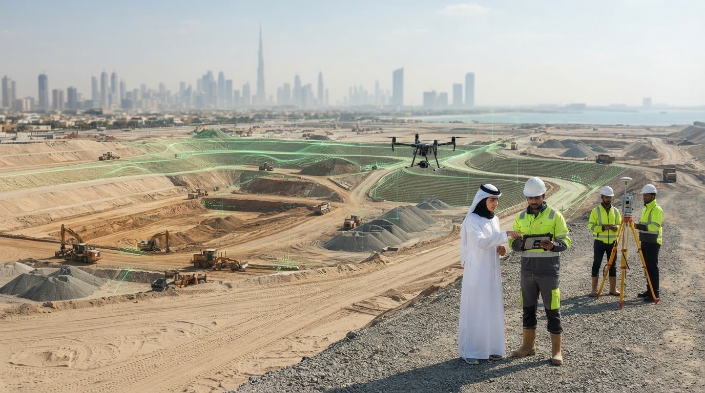
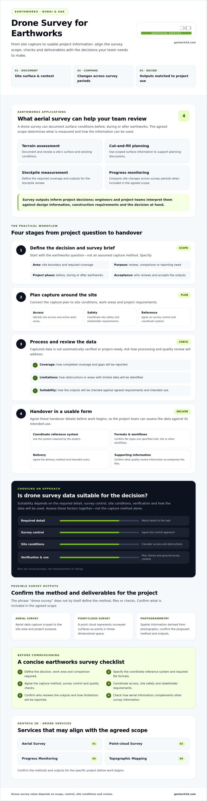
Could aerial data help your earthworks team make better decisions, or leave you with files that don’t answer the questions on site? A drone survey for earthworks can support terrain assessment, cut-and-fill planning, stockpile measurement and progress monitoring. Its value depends on whether the survey scope, checks and deliverables match the decisions you need to make.
It’s reasonable to ask whether drone data is reliable enough for project use. Suitability depends on the required detail, survey control, site conditions and how the outputs will be checked and used. Agreeing on requirements before work begins helps your team assess whether aerial data fits the task and how it should complement other survey information.
This guide covers practical earthworks applications and what to request, including a coordinate reference system, deliverable formats and quality checks. It also explains access, site safety and coordination considerations for Dubai and UAE projects. GEOTECH 3D provides Drone Services including Aerial Survey, Point-cloud Survey and Progress Monitoring. Confirm the methods and outputs for your specific project.
Key Takeaways
- A drone survey for earthworks can document surfaces and support progress reviews when the scope fits the project’s needs.
- Understand how aerial data will be captured, processed and reviewed before handover.
- Assess whether data suits your decisions by considering survey control, verification and how it complements ground survey.
- Prepare a clear survey brief covering outputs, site access, safety coordination and stakeholder requirements.
- Explore how GEOTECH 3D’s Aerial Survey, Point-cloud Survey, Progress Monitoring and Topographic Mapping services may align with your project scope.
What a drone survey for earthworks measures on a Dubai project
A drone survey for earthworks uses aerial data capture to produce project-specific mapping or survey outputs that document and help review a site’s surface. The data can help teams understand site context and surface changes before, during or after earthworks. The scope determines what is measured and how the information can be used.
Survey outputs inform project decisions, but don’t make them. Engineers and project teams interpret the data against design information, construction requirements and the decision at hand. A mapped surface, for example, may help a team review site conditions, while repeat surveys may help compare changes across a work area.
Which earthworks questions can aerial survey help answer?
Aerial survey may document existing conditions before work begins, record the surface during construction or provide a later snapshot for review. GEOTECH 3D lists Progress Monitoring as a Drone Services offering. If included in the agreed scope, it can support review of site changes across survey periods. Before choosing outputs, define the decision or report you need to support, the area to cover and the comparison required.
What might a drone earthworks survey deliver?
GEOTECH 3D lists Aerial Survey and Point-cloud Survey under Drone Services, and Digital Photogrammetry Services under GIS & Surveying Services. Photogrammetry derives spatial information from photographs. Read more about the method in this overview of Photogrammetry. A point cloud is a set of data points representing surveyed surfaces in three dimensions.
Depending on the agreed scope and method, outputs might include mapped surface information or point-cloud data. Confirm what is included before commissioning the work. Agree on:
- Coverage: the work area and any required boundaries.
- Coordinate reference system: the system the project needs the data to use.
- Formats and handover: file types, delivery method and intended users.
- Purpose: the earthworks review or reporting need the outputs must support.
Ask the provider to confirm the methods, control approach and quality checks for the specific site. Clear requirements give the survey team a basis for proposing suitable outputs and help stakeholders judge whether the data meets its intended use.
How drone survey data is collected and prepared for earthworks
A useful survey workflow starts with the project decision, not the capture method. For a drone survey for earthworks, connect the site area, construction phase and intended use to the information required. The capture plan and proposed outputs should then account for site conditions and project requirements.
Captured data is not automatically verified, project-ready survey information. It needs to be processed, reviewed against agreed requirements and handed over in a form the project team can use. Photogrammetry uses overlapping photographs to derive spatial information, while a point cloud represents surfaces as points in three-dimensional space. Confirm the proposed method and outputs for the project rather than assuming them from the term “drone survey.”
What should be agreed before the drone survey?
Prepare a brief that identifies the site boundary, earthworks phases, decisions to support and requested deliverables. Identify active work areas and discuss access, safety coordination and site requirements with relevant stakeholders before planning capture. Agree on reference information, the control approach and coordinate system. Also identify who will review and accept the outputs. These details connect the capture plan to the project’s actual needs.
How does captured data become usable project information?
After capture, the data is processed into the agreed mapping or other survey outputs. Depending on the scope and method, processing may derive mapped information from photographs or produce a point-cloud representation. Ask how the provider will identify and report gaps, obstructions or other limitations that could affect interpretation. Confirm that the proposed formats suit the project’s CAD, GIS or other specified workflows.
Before handover, establish what quality review will be performed and what supporting information will accompany the outputs. Ask whether files use the agreed coordinate reference system, how coverage will be reported and how to interpret areas with limited data. External material, such as industry technical guidelines, can provide background, but project requirements and the confirmed survey scope should guide decisions.
For Dubai and UAE projects, coordinate survey planning with the site team and relevant stakeholders. Address access, active operations and handover expectations together. To discuss how defined requirements may align with GEOTECH 3D’s Drone Services, share the project’s intended use and required outputs.
Is a drone survey accurate enough for earthworks decisions?
A drone survey may suit some earthworks decisions, but neither the word “drone” nor a single accuracy figure establishes suitability. The answer depends on the decision, scope, control approach, site conditions and verification method. Before commissioning a drone survey for earthworks, ask for project-specific specifications and evidence showing how the proposed outputs will be checked against your requirements.
Aerial and ground surveys serve different purposes and can complement one another. Aerial data may suit broad site documentation or progress review. Ground survey or targeted checks may be needed when the project requires specific detail or access is limited. Neither method is a universal substitute for the other. Agree with the survey provider and project engineer on the information appropriate for each decision.
When might aerial data suit an earthworks workflow?
Depending on the scope, aerial survey may provide a record of surface conditions across a work area or help the team review changes between agreed survey periods. Visibility, terrain, access and active site operations can affect capture planning. Discuss these constraints in advance, including areas that may be obscured or difficult to capture, and agree how limitations will be reported. GEOTECH 3D lists Aerial Survey and Progress Monitoring among its Drone Services. Confirm methods and outputs for the specific site.
When should ground survey or additional checks be considered?
Plan explicit verification for design-critical areas, obstructed locations or places where site conditions constrain aerial capture. The provider and project engineer should identify where complementary ground checks are needed and how results will be reviewed. If earthworks interface with underground assets, surface data alone doesn’t confirm buried utility locations. Include underground asset information needs in the survey brief, and discuss whether utilities mapping and GPR are relevant.
Use a comparison matrix to connect each decision with the right information. For each work area or task, record:
- Use case: the earthworks question or reporting need.
- Required detail: the level and type of information the decision requires.
- Access: whether the area is visible and accessible for the proposed capture or ground checks.
- Deliverable: the agreed data or survey output and its format.
- Verification method: the checks, control information or complementary survey needed to assess suitability.
This framework helps the team avoid choosing a method based on broad claims alone. Request the proposed control approach, quality review and project-specific evidence, then confirm with the engineer that the outputs suit their intended use.
How to scope a drone survey for earthworks in Dubai and the UAE
A clear survey brief connects the site, intended decisions and required outputs before mobilization. For a drone survey for earthworks, this helps the provider plan around the project phase and site conditions. It also gives contractors, consultants and engineers a shared basis for reviewing the results.
What information belongs in the survey brief?
Describe where the work is taking place and what the survey must support. Include the survey boundary, current earthworks stage, priority areas and intended use, such as documenting site conditions or reviewing progress. Specify the outputs the project team expects instead of making a general request for “drone data.”
- Data requirements: requested deliverables, file formats and coordinate reference system.
- Review and handover: who will check the outputs, how they will be delivered and any project-specific acceptance expectations.
- Site coordination: site contacts, access constraints, safety arrangements, active work areas and suitable coordination windows.
Include reference information for the survey team and identify stakeholders who need to coordinate or review the work. A well-defined brief makes it easier to discuss scope, limitations and handover before capture is scheduled.
What should the project team verify before mobilization?
Confirm who is responsible for arranging site access, safety induction and coordination with active contractors. Discuss nearby activity that could affect access or planning, and agree how the survey team and site representatives will communicate during the work. Confirm applicable Dubai and UAE permissions and operational requirements with the responsible stakeholders for the specific project. Requirements may vary by site and operation, so don’t assume they are identical across projects.
Before work starts, agree how the provider will report areas that are inaccessible, obscured or otherwise not captured as planned. Establish how scope changes will be raised, assessed and approved, and who can authorize them. This gives the project team a clear record of the surveyed area and any gaps that may need follow-up.
For a practical review, check that the brief answers these questions:
- Does it define the site boundary, phase, purpose and priority areas?
- Are formats, coordinate reference, review responsibilities and handover expectations stated?
- Are access, safety coordination and stakeholder requirements assigned to named project contacts?
- Have applicable permissions and operational requirements been confirmed with responsible stakeholders?
- Is there an agreed process for reporting gaps and approving scope changes?
How GEOTECH 3D can support a Dubai earthworks survey
Once the intended decisions and survey requirements are clear, GEOTECH 3D’s listed services provide a starting point for a project discussion. Its Drone Services include Aerial Survey, Point-cloud Survey and Progress Monitoring. Under GIS & Surveying Services, the company lists Topographic Mapping. The service, method and outputs suitable for a drone survey for earthworks depend on the project brief and site conditions.
Define what the survey needs to support, then confirm the proposed scope, methods, formats, control approach and verification process with the provider. Don’t assume a particular file type or integration is included. Clear agreement helps the survey team and project stakeholders align capture and handover with the intended use.
What to include when requesting a survey discussion
Share the site location, current earthworks phase and decisions the project team needs to make. Include available drawings or reference information, the survey boundary and priority areas. Describe the outputs you’re considering, preferred formats, interfaces with existing project systems and how the team expects to review the information. These details help frame a project-specific discussion without presuming a deliverable is available or appropriate.
Also identify access constraints, site safety requirements and key coordination contacts, including representatives for active work areas. If the survey relates to repeated progress reviews, explain the intended review process so its scope can be discussed against the project’s reporting needs.
How survey data can connect with wider project information
Agreeing on data handover matters as much as selecting outputs. Confirm how proposed files should align with the project’s existing GIS or CAD workflow, what reference information is needed and who will check compatibility. This helps the team assess how survey information fits alongside other project data.
Share your project requirements with GEOTECH 3D to discuss how its listed services may align with a Dubai earthworks survey.
Set Your Earthworks Survey Up for Clearer Decisions
A drone survey for earthworks is most useful when its scope and outputs match the decisions your project team needs to make. Define site coverage, intended use, deliverable formats and the review process before work begins. Then confirm the proposed methods, control and verification requirements for your Dubai or UAE site.
Aerial data can support site documentation and progress review, while ground survey or additional checks may be appropriate for design-critical or obstructed areas. Treat these approaches as complementary where needed, and agree how limitations will be identified and reported.
GEOTECH 3D lists Aerial Survey, Point-cloud Survey and Progress Monitoring under Drone Services, and identifies Dubai, UAE, as a service location. With a clear brief and coordinated expectations, your team can assess aerial data and plan next steps using information suited to the project.
Frequently Asked Questions
What is a drone survey for earthworks?
A drone survey for earthworks is aerial data capture planned to support project-specific mapping, site documentation or progress review. The agreed scope determines which outputs are produced and how they may be used. Define the decisions the data needs to support, then confirm deliverables, file formats, reference information and quality checks with the surveying provider.
Can a drone survey calculate earthworks volumes?
A drone survey may support volume-related workflows when the scope, suitable survey data, reference surfaces and required checks are agreed. Don’t assume every aerial survey includes a volume calculation or that its outputs suit every contractual purpose. Ask the provider to confirm the proposed method, required inputs, deliverable format and validation process for your site. Agree how the project team will review and apply the results.
How accurate is a drone survey for earthworks?
There isn’t one accuracy figure that applies to every site or survey. Suitability depends on the project specification, capture conditions, survey control, verification approach and intended decisions. Request project-specific accuracy information and quality documentation before relying on results for design, measurement or commercial decisions. Ask how the proposed checks relate to your requirements, and avoid comparing providers using headline figures that haven’t been verified for your project conditions.
What is the difference between a drone survey and a ground survey?
A drone survey collects aerial data, while a ground survey gathers measurements at site level. Their suitability depends on coverage, access, required detail and intended use. The approaches can complement each other rather than act as universal substitutes. Ask the project surveyor to identify where ground checks or other verification are needed, particularly where access, visibility or the decision requires additional information.
What information should I provide before requesting an earthworks drone survey in Dubai?
Provide the site location and boundary, earthworks phase, intended decisions, requested outputs, file formats and coordinate reference requirements. Include access constraints, active work areas, safety arrangements and stakeholder contacts so planning accounts for site coordination. For projects in Dubai or elsewhere in the UAE, confirm applicable local and project-specific requirements with responsible parties. Ask the surveying provider what further information or permissions are needed before capture planning proceeds.
Can drone surveys monitor earthworks progress over time?
Progress monitoring may be included when agreed as part of the service scope. Define the areas and project stages to compare, reporting format, reference information and review responsibilities before work begins. Confirm how inaccessible or changed areas will be documented. GEOTECH 3D lists Progress Monitoring under Drone Services. Check the project-specific availability, proposed method and outputs with the provider so the monitoring plan fits your site and reporting needs.
Could aerial data help your earthworks team make better decisions, or leave you with files that don’t answer the questions on site? A drone survey for earthworks can support terrain assessment, cut-and-fill planning, stockpile measurement and progress monitoring. Its value depends on whether the survey scope, checks and deliverables match the decisions you need to make.
It’s reasonable to ask whether drone data is reliable enough for project use. Suitability depends on the required detail, survey control, site conditions and how the outputs will be checked and used. Agreeing on requirements before work begins helps your team assess whether aerial data fits the task and how it should complement other survey information.
This guide covers practical earthworks applications and what to request, including a coordinate reference system, deliverable formats and quality checks. It also explains access, site safety and coordination considerations for Dubai and UAE projects. GEOTECH 3D provides Drone Services including Aerial Survey, Point-cloud Survey and Progress Monitoring. Confirm the methods and outputs for your specific project.
Key Takeaways
- A drone survey for earthworks can document surfaces and support progress reviews when the scope fits the project’s needs.
- Understand how aerial data will be captured, processed and reviewed before handover.
- Assess whether data suits your decisions by considering survey control, verification and how it complements ground survey.
- Prepare a clear survey brief covering outputs, site access, safety coordination and stakeholder requirements.
- Explore how GEOTECH 3D’s Aerial Survey, Point-cloud Survey, Progress Monitoring and Topographic Mapping services may align with your project scope.
What a drone survey for earthworks measures on a Dubai project
A drone survey for earthworks uses aerial data capture to produce project-specific mapping or survey outputs that document and help review a site’s surface. The data can help teams understand site context and surface changes before, during or after earthworks. The scope determines what is measured and how the information can be used.
Survey outputs inform project decisions, but don’t make them. Engineers and project teams interpret the data against design information, construction requirements and the decision at hand. A mapped surface, for example, may help a team review site conditions, while repeat surveys may help compare changes across a work area.
Which earthworks questions can aerial survey help answer?
Aerial survey may document existing conditions before work begins, record the surface during construction or provide a later snapshot for review. GEOTECH 3D lists Progress Monitoring as a Drone Services offering. If included in the agreed scope, it can support review of site changes across survey periods. Before choosing outputs, define the decision or report you need to support, the area to cover and the comparison required.
What might a drone earthworks survey deliver?
GEOTECH 3D lists Aerial Survey and Point-cloud Survey under Drone Services, and Digital Photogrammetry Services under GIS & Surveying Services. Photogrammetry derives spatial information from photographs. Read more about the method in this overview of Photogrammetry. A point cloud is a set of data points representing surveyed surfaces in three dimensions.
Depending on the agreed scope and method, outputs might include mapped surface information or point-cloud data. Confirm what is included before commissioning the work. Agree on:
- Coverage: the work area and any required boundaries.
- Coordinate reference system: the system the project needs the data to use.
- Formats and handover: file types, delivery method and intended users.
- Purpose: the earthworks review or reporting need the outputs must support.
Ask the provider to confirm the methods, control approach and quality checks for the specific site. Experienced aerial survey providers such as TDB Solutions emphasize rigorous ground control and data verification to ensure deliverables meet engineering standards. Clear requirements give the survey team a basis for proposing suitable outputs and help stakeholders judge whether the data meets its intended use.
How drone survey data is collected and prepared for earthworks
A useful survey workflow starts with the project decision, not the capture method. For a drone survey for earthworks, connect the site area, construction phase and intended use to the information required. The capture plan and proposed outputs should then account for site conditions and project requirements.
Captured data is not automatically verified, project-ready survey information. It needs to be processed, reviewed against agreed requirements and handed over in a form the project team can use. Photogrammetry uses overlapping photographs to derive spatial information, while a point cloud represents surfaces as points in three-dimensional space. Confirm the proposed method and outputs for the project rather than assuming them from the term “drone survey.”
What should be agreed before the drone survey?
Prepare a brief that identifies the site boundary, earthworks phases, decisions to support and requested deliverables. Identify active work areas and discuss access, safety coordination and site requirements with relevant stakeholders before planning capture. Agree on reference information, the control approach and coordinate system. Also identify who will review and accept the outputs. These details connect the capture plan to the project’s actual needs.
How does captured data become usable project information?
After capture, the data is processed into the agreed mapping or other survey outputs. Depending on the scope and method, processing may derive mapped information from photographs or produce a point-cloud representation. Ask how the provider will identify and report gaps, obstructions or other limitations that could affect interpretation. Confirm that the proposed formats suit the project’s CAD, GIS or other specified workflows.
Before handover, establish what quality review will be performed and what supporting information will accompany the outputs. Ask whether files use the agreed coordinate reference system, how coverage will be reported and how to interpret areas with limited data. External material, such as industry technical guidelines, can provide background, but project requirements and the confirmed survey scope should guide decisions.
For Dubai and UAE projects, coordinate survey planning with the site team and relevant stakeholders. Address access, active operations and handover expectations together. To discuss how defined requirements may align with GEOTECH 3D’s Drone Services, share the project’s intended use and required outputs.
Is a drone survey accurate enough for earthworks decisions?
A drone survey may suit some earthworks decisions, but neither the word “drone” nor a single accuracy figure establishes suitability. The answer depends on the decision, scope, control approach, site conditions and verification method. Before commissioning a drone survey for earthworks, ask for project-specific specifications and evidence showing how the proposed outputs will be checked against your requirements.
Aerial and ground surveys serve different purposes and can complement one another. Aerial data may suit broad site documentation or progress review. Ground survey or targeted checks may be needed when the project requires specific detail or access is limited. Neither method is a universal substitute for the other. Agree with the survey provider and project engineer on the information appropriate for each decision.
When might aerial data suit an earthworks workflow?
Depending on the scope, aerial survey may provide a record of surface conditions across a work area or help the team review changes between agreed survey periods. Visibility, terrain, access and active site operations can affect capture planning. Discuss these constraints in advance, including areas that may be obscured or difficult to capture, and agree how limitations will be reported. GEOTECH 3D lists Aerial Survey and Progress Monitoring among its Drone Services. Confirm methods and outputs for the specific site.
When should ground survey or additional checks be considered?
Plan explicit verification for design-critical areas, obstructed locations or places where site conditions constrain aerial capture. The provider and project engineer should identify where complementary ground checks are needed and how results will be reviewed. If earthworks interface with underground assets, surface data alone doesn’t confirm buried utility locations. Include underground asset information needs in the survey brief, and discuss whether utilities mapping and GPR are relevant.
Use a comparison matrix to connect each decision with the right information. For each work area or task, record:
- Use case: the earthworks question or reporting need.
- Required detail: the level and type of information the decision requires.
- Access: whether the area is visible and accessible for the proposed capture or ground checks.
- Deliverable: the agreed data or survey output and its format.
- Verification method: the checks, control information or complementary survey needed to assess suitability.
This framework helps the team avoid choosing a method based on broad claims alone. Request the proposed control approach, quality review and project-specific evidence, then confirm with the engineer that the outputs suit their intended use.
How to scope a drone survey for earthworks in Dubai and the UAE
A clear survey brief connects the site, intended decisions and required outputs before mobilization. For a drone survey for earthworks, this helps the provider plan around the project phase and site conditions. It also gives contractors, consultants and engineers a shared basis for reviewing the results.
What information belongs in the survey brief?
Describe where the work is taking place and what the survey must support. Include the survey boundary, current earthworks stage, priority areas and intended use, such as documenting site conditions or reviewing progress. Specify the outputs the project team expects instead of making a general request for “drone data.”
- Data requirements: requested deliverables, file formats and coordinate reference system.
- Review and handover: who will check the outputs, how they will be delivered and any project-specific acceptance expectations.
- Site coordination: site contacts, access constraints, safety arrangements, active work areas and suitable coordination windows.
Include reference information for the survey team and identify stakeholders who need to coordinate or review the work. A well-defined brief makes it easier to discuss scope, limitations and handover before capture is scheduled.
What should the project team verify before mobilization?
Confirm who is responsible for arranging site access, safety induction and coordination with active contractors. Discuss nearby activity that could affect access or planning, and agree how the survey team and site representatives will communicate during the work. Confirm applicable Dubai and UAE permissions and operational requirements with the responsible stakeholders for the specific project. Requirements may vary by site and operation, so don’t assume they are identical across projects.
Before work starts, agree how the provider will report areas that are inaccessible, obscured or otherwise not captured as planned. Establish how scope changes will be raised, assessed and approved, and who can authorize them. This gives the project team a clear record of the surveyed area and any gaps that may need follow-up.
For a practical review, check that the brief answers these questions:
- Does it define the site boundary, phase, purpose and priority areas?
- Are formats, coordinate reference, review responsibilities and handover expectations stated?
- Are access, safety coordination and stakeholder requirements assigned to named project contacts?
- Have applicable permissions and operational requirements been confirmed with responsible stakeholders?
- Is there an agreed process for reporting gaps and approving scope changes?
How GEOTECH 3D can support a Dubai earthworks survey
Once the intended decisions and survey requirements are clear, GEOTECH 3D’s listed services provide a starting point for a project discussion. Its Drone Services include Aerial Survey, Point-cloud Survey and Progress Monitoring. Under GIS & Surveying Services, the company lists Topographic Mapping. The service, method and outputs suitable for a drone survey for earthworks depend on the project brief and site conditions.
Define what the survey needs to support, then confirm the proposed scope, methods, formats, control approach and verification process with the provider. Don’t assume a particular file type or integration is included. Clear agreement helps the survey team and project stakeholders align capture and handover with the intended use.
What to include when requesting a survey discussion
Share the site location, current earthworks phase and decisions the project team needs to make. Include available drawings or reference information, the survey boundary and priority areas. Describe the outputs you’re considering, preferred formats, interfaces with existing project systems and how the team expects to review the information. These details help frame a project-specific discussion without presuming a deliverable is available or appropriate.
Also identify access constraints, site safety requirements and key coordination contacts, including representatives for active work areas. If the survey relates to repeated progress reviews, explain the intended review process so its scope can be discussed against the project’s reporting needs.
How survey data can connect with wider project information
Agreeing on data handover matters as much as selecting outputs. Confirm how proposed files should align with the project’s existing GIS or CAD workflow, what reference information is needed and who will check compatibility. This helps the team assess how survey information fits alongside other project data.
Share your project requirements with GEOTECH 3D to discuss how its listed services may align with a Dubai earthworks survey.
Set Your Earthworks Survey Up for Clearer Decisions
A drone survey for earthworks is most useful when its scope and outputs match the decisions your project team needs to make. Define site coverage, intended use, deliverable formats and the review process before work begins. Then confirm the proposed methods, control and verification requirements for your Dubai or UAE site.
Aerial data can support site documentation and progress review, while ground survey or additional checks may be appropriate for design-critical or obstructed areas. Treat these approaches as complementary where needed, and agree how limitations will be identified and reported.
GEOTECH 3D lists Aerial Survey, Point-cloud Survey and Progress Monitoring under Drone Services, and identifies Dubai, UAE, as a service location. With a clear brief and coordinated expectations, your team can assess aerial data and plan next steps using information suited to the project.
Frequently Asked Questions
What is a drone survey for earthworks?
A drone survey for earthworks is aerial data capture planned to support project-specific mapping, site documentation or progress review. The agreed scope determines which outputs are produced and how they may be used. Define the decisions the data needs to support, then confirm deliverables, file formats, reference information and quality checks with the surveying provider.
Can a drone survey calculate earthworks volumes?
A drone survey may support volume-related workflows when the scope, suitable survey data, reference surfaces and required checks are agreed. Don’t assume every aerial survey includes a volume calculation or that its outputs suit every contractual purpose. Ask the provider to confirm the proposed method, required inputs, deliverable format and validation process for your site. Agree how the project team will review and apply the results.
How accurate is a drone survey for earthworks?
There isn’t one accuracy figure that applies to every site or survey. Suitability depends on the project specification, capture conditions, survey control, verification approach and intended decisions. Request project-specific accuracy information and quality documentation before relying on results for design, measurement or commercial decisions. Ask how the proposed checks relate to your requirements, and avoid comparing providers using headline figures that haven’t been verified for your project conditions.
What is the difference between a drone survey and a ground survey?
A drone survey collects aerial data, while a ground survey gathers measurements at site level. Their suitability depends on coverage, access, required detail and intended use. The approaches can complement each other rather than act as universal substitutes. Ask the project surveyor to identify where ground checks or other verification are needed, particularly where access, visibility or the decision requires additional information.
What information should I provide before requesting an earthworks drone survey in Dubai?
Provide the site location and boundary, earthworks phase, intended decisions, requested outputs, file formats and coordinate reference requirements. Include access constraints, active work areas, safety arrangements and stakeholder contacts so planning accounts for site coordination. For projects in Dubai or elsewhere in the UAE, confirm applicable local and project-specific requirements with responsible parties. Ask the surveying provider what further information or permissions are needed before capture planning proceeds.
Can drone surveys monitor earthworks progress over time?
Progress monitoring may be included when agreed as part of the service scope. Define the areas and project stages to compare, reporting format, reference information and review responsibilities before work begins. Confirm how inaccessible or changed areas will be documented. GEOTECH 3D lists Progress Monitoring under Drone Services. Check the project-specific availability, proposed method and outputs with the provider so the monitoring plan fits your site and reporting needs.
Search Now
Error: Contact form not found.