

Our Services
Reducing Project Delays with Accurate Surveys in Dubai
A survey can be accurate and still fail to prevent a delay if its scope or deliverables don’t support the decision at hand. Reducing project delays with accurate surveys Dubai teams can rely on means getting the right site information to the right people before key decisions are made.
Unmapped utilities or incomplete information about site conditions can affect design and construction planning. Even when the fieldwork is complete, unclear deliverables may leave downstream teams without information they can use. Teams can reduce this uncertainty by agreeing on survey needs early and aligning them with project milestones.
This article explains how suitable survey data can help teams understand site conditions and coordinate decisions. It covers when Topographic Mapping and Utility Mapping (GPR) may be relevant, what to clarify about scope, coordinate systems, accuracy requirements and deliverable formats, and how to plan survey inputs and reviews around key decisions. GEOTECH 3D provides these services for construction and development applications in Dubai and across the UAE. Survey data can support informed planning, but it cannot guarantee a project will avoid delays.
Key Takeaways
- Match survey inputs to the decisions and milestones they need to support. Accurate surveys inform planning, but can’t guarantee a delay-free project.
- Agree on scope, reference information, accuracy requirements and deliverable formats so downstream teams can use the data consistently.
- Choose between Topographic Mapping, Utility Mapping (GPR) and other survey approaches based on the project question, site conditions and required deliverables.
- For reducing project delays with accurate surveys Dubai teams should identify decision owners, data users, site constraints and review points before commissioning survey work.
- Explore how GEOTECH 3D’s Topographic Mapping and GIS & Surveying Services can support project planning. Consider Utility Mapping (GPR) when subsurface utility information is relevant.
How Accurate Surveys in Dubai Help Address Project Delay Risks
Design and construction decisions based on incomplete or unsuitable site information can create avoidable uncertainty. A team might be relying on an outdated view of existing conditions, or have data that doesn’t answer the question at hand. On a Dubai project, agreeing what needs to be known and when helps survey information support planning and coordination instead of becoming a disconnected deliverable.
Project-ready survey data is current, appropriately scoped information that can be used for the decision it is meant to support. Accuracy matters, but no single accuracy figure makes every survey suitable for every task. Scope, currency, reference information and intended use matter too. The science of surveying provides ways to measure and represent land and features. Project teams still need to define which information they require and how they will use it.
Which project decisions depend on reliable site information?
Common considerations include site layout, levels, boundaries and visible existing conditions. Design teams may need information to assess how a proposed layout relates to the site. Construction teams may use it to plan work around known features and levels. Project managers need to know what information is available, who relies on it and whether it is ready for upcoming decisions. These are general planning examples, not GEOTECH 3D project case studies.
Clear survey inputs help teams identify questions early and coordinate how to address them. Surveys don’t replace design review or construction planning, but they can provide those processes with a clearer basis for understanding site conditions.
Why can a survey fail to prevent schedule problems?
A survey may be accurately completed and still fall short if its scope omits a feature relevant to the decision, its information is no longer current, or its deliverables don’t suit the downstream team’s workflow. Before work begins, clarify the intended use, required coverage, reference information and deliverable formats with the project team. Confirm project-specific accuracy requirements rather than assuming one standard fits every task.
Surveying also can’t control late design changes, coordination issues or other external project factors. It informs decisions, but it doesn’t guarantee that a project will avoid delays. Commissioning survey work takes planning, yet postponing essential site information can leave teams making decisions with unresolved questions. Identifying those needs early gives the project team an opportunity to address them before they complicate later coordination.
For teams focused on reducing project delays with accurate surveys Dubai, the aim isn’t simply to collect more data. It is to get suitable information in time for a defined decision and make sure the people who depend on it can use it.
How Survey Accuracy and Data Handover Support Dubai Project Coordination
Survey accuracy is not a universal number. It means the information meets the project’s stated requirements and is suitable for its intended use. Teams need to agree on what must be measured, how the data will be referenced and which formats downstream users can work with. Without that alignment, technically sound information may still be difficult to apply consistently.
Usable survey data depends on clear requirements, coordinated review and a handover that fits the project workflow. This matters when survey information will inform design development, construction planning or coordination with other project records.
What should teams agree before a Dubai survey begins?
Set out the site area, the decisions the information will support, interfaces with adjacent work and the deliverables required. Confirm the project coordinate system, control information and accuracy criteria with the relevant technical team rather than assuming a standard applies. Clarify site access, safety arrangements and stakeholder responsibilities before mobilization. These discussions help define what the survey needs to capture and who will review the results.
Where design work needs to align with applicable Dubai requirements, teams can consult the Dubai Building Code and confirm project criteria with the responsible professionals. A code reference does not define survey scope or establish whether collected data is suitable for a particular design decision.
How do survey outputs move into project workflows?
A clear handover follows a practical sequence: collect information against the agreed scope, review the deliverables for completeness and suitability, then release them to the teams making dependent decisions. Before using the data, recipients should check that the site area and required information are covered, reference details are clear, and files match the agreed formats.
CAD or BIM coordination may be relevant when those workflows are part of the project scope. For renovation planning, for example, teams may consider whether 3D laser scanning for renovation is appropriate for documenting existing conditions, then confirm the required outputs and how they will be used. Don’t assume a method or file format without agreement among project participants.
For teams focused on reducing project delays with accurate surveys Dubai, treat review and handover as planned project activities, not administrative steps after fieldwork. Discussing requirements with GEOTECH 3D’s surveying team can help clarify the information, deliverables and coordination needs for the project.
Which Survey Approach Fits Your Dubai Project: Topographic, Utility, or 3D?
Start with the site question, not the technology. A team planning earthworks may need mapped terrain information, while a team assessing an excavation area may need subsurface utility information. Renovation or retrofit planning may call for a record of existing built conditions. These needs can require different methods, and some projects may need more than one approach.
The right choice depends on site conditions, project stage, intended decisions and deliverables. The RICS construction standards provide broader construction-sector guidance, but survey scope still needs to be agreed for the specific project.
| Project question | Relevant survey approach | Scope to confirm |
|---|---|---|
| What are the site layout and terrain conditions relevant to planning? | Topographic Mapping | Site coverage, levels, reference information, and intended design use. |
| What subsurface utility information is needed for planned work? | Utility Mapping (GPR) | Survey area, utility information required, site constraints, and how results will inform decisions. |
| What are the existing conditions of a structure or complex built area? | 3D Laser Scanning or other 3D data capture, where suitable | Areas to capture, intended use, and required outputs for design or coordination. |
| Is aerial information appropriate to the site-planning question? | Aerial survey | Coverage, project purpose, and how the information will be used alongside other site data. |
When does Topographic Mapping help project teams?
Topographic Mapping is relevant when teams need mapped site or terrain information for planning and design. Before commissioning it, clarify the area to be covered, required levels, reference information and how designers will use the data. It answers a different question from utility mapping or 3D capture, though those methods may complement it when a project has additional information needs.
When should teams consider Utility Mapping (GPR) or 3D data capture?
Consider Utility Mapping (GPR) when subsurface utility information is relevant to the project scope. Confirm the area and information required for the specific site. Don’t assume it provides every detail needed for every below-ground decision. For more context, teams can explore subsurface utility engineering in Dubai.
3D Laser Scanning may suit projects that need to document existing structures or complex built conditions. It isn’t interchangeable with Topographic Mapping or Utility Mapping (GPR). Scan-derived models may also be relevant to BIM workflows, depending on the required outputs. For teams reducing project delays with accurate surveys Dubai, choosing based on the project question helps align the method with a decision instead of collecting data without a defined use.
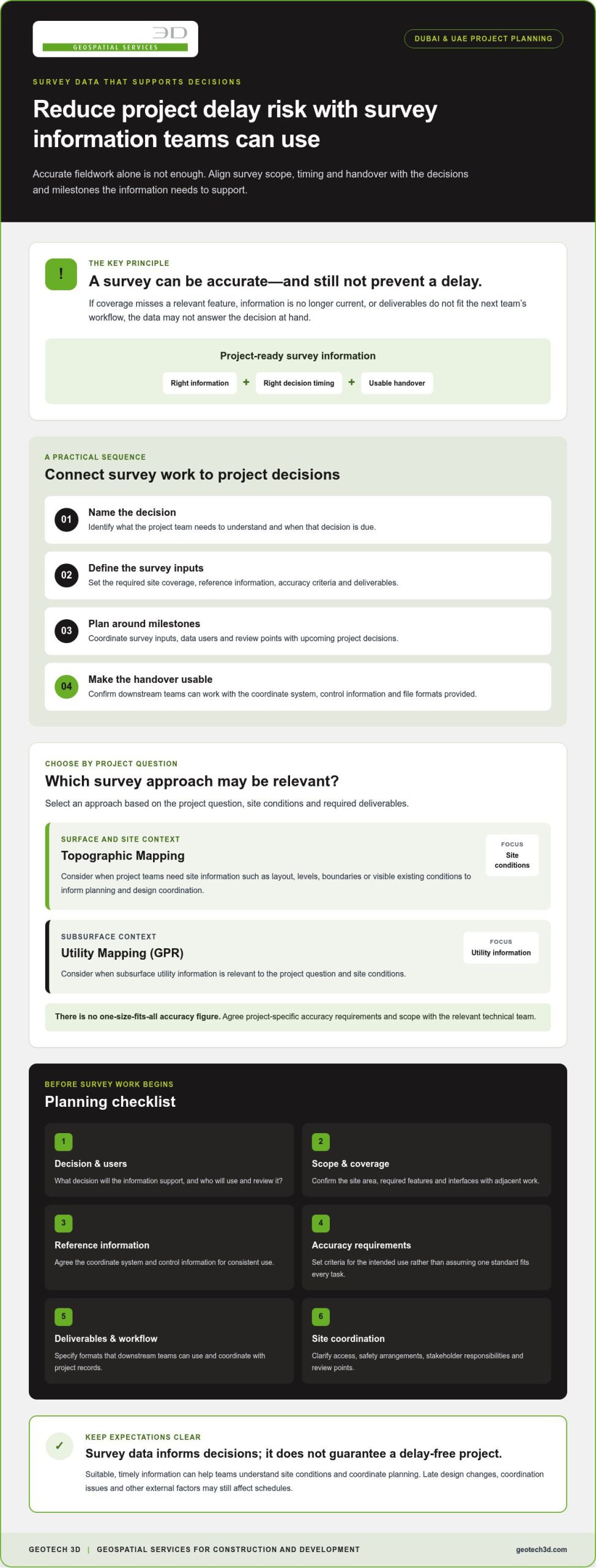
A Practical Survey Planning Checklist for Reducing Delay Risk in Dubai
A survey is easier to coordinate when the team defines its purpose before collection begins and assigns someone to review the results before dependent work proceeds. Use this sequence to connect the project decision, survey scope, site arrangements and data handover.
Before commissioning a survey
- 1. Define the decision. State the project question the survey must support, such as checking site levels for design coordination or identifying subsurface utility information for planned work.
- 2. Set the boundary and information needs. Identify the site area, required features or conditions, and how the information will be used. Explain the intended use to both the survey team and downstream users.
- 3. Identify people and interfaces. Name the decision owner, expected data users and stakeholders whose work interfaces with the survey. Note relevant existing information and known site constraints.
- 4. Confirm technical requirements and deliverables. Agree on required formats and confirm project-specific coordinate systems, control information, accuracy criteria and review milestones with the relevant project team. Requirements depend on the site and intended use, so don’t assume a generic specification is suitable.
- 5. Plan site arrangements. Confirm access, safety planning, stakeholder responsibilities and constraints that could affect survey activities before mobilization.
After data collection: review before dependent work proceeds
- 6. Assign a reviewer. Have a responsible project team member compare the delivered information with the agreed scope and expected coverage. Check that the intended site area and requested information are represented.
- 7. Check usability and completeness. Confirm that files are in the agreed formats and reference information is clear enough for the intended workflow. For CAD or BIM coordination, check that outputs suit the agreed project process instead of assuming compatibility.
- 8. Record unresolved items. Document assumptions, gaps and questions that need clarification. Don’t let dependent decisions rely on information the team hasn’t reviewed or understood.
- 9. Coordinate the handover. Use a project meeting to confirm which outputs are approved for use, where they will be shared, how they should be referenced and who will communicate any updates.
This checklist supports reducing project delays with accurate surveys Dubai by making responsibilities and information needs visible early. It isn’t a substitute for confirming project-specific requirements or applicable authority procedures with the responsible project team.
How GEOTECH 3D Supports Survey Planning for Dubai Projects
Survey planning starts with the information a project needs, not a predetermined method. A development team may need mapped site information to inform layout decisions, while another project may need subsurface utility information before planning work in a specific area. Matching the service to the question helps define a useful scope and gives stakeholders a clearer basis for coordination.
GEOTECH 3D provides Topographic Mapping and GIS & Surveying Services for construction, infrastructure and development applications in Dubai and the UAE. The company states a focus on accurate data collection, strict safety compliance and meeting tight schedules. These are relevant planning considerations, not a guarantee that a survey will prevent project delays.
Match GEOTECH 3D survey services to project requirements
Topographic Mapping is relevant when a team needs mapped site information for planning or design. Define the area to cover, the information required and how designers or other users will apply the results. This connects the scope to the intended decision instead of relying on assumptions about what a general survey should include.
Utility Mapping (GPR) is a distinct option when subsurface utility information is relevant to the project scope. It addresses a different site-information need from Topographic Mapping, so teams should identify the area and questions the mapping needs to address. Before work begins, confirm the exact scope, deliverables, coordinate system, accuracy requirements and review milestones with the relevant project team.
For teams focused on reducing project delays with accurate surveys Dubai, the key is to align survey inputs with upcoming decisions and the people who will use them. GEOTECH 3D’s stated emphasis on safety compliance and tight schedules can inform early coordination, while project requirements and outcomes remain specific to each assignment.
What to prepare for a project discussion
A focused discussion is easier when the project team can describe the context. Prepare the project location and current stage, relevant site information already available, and the decisions the survey should support. Identify who will review and use the outputs, including stakeholders whose work interfaces with the survey scope.
It also helps to outline required deliverable formats, target project milestones, access considerations and known site constraints. These details allow the team to clarify what is needed, what must be confirmed and how the information will be coordinated after handover. Don’t assume a standard scope or deliverable without project-specific agreement.
To discuss survey requirements, deliverables and coordination needs for your Dubai project, explore GEOTECH 3D surveying services.
Make Survey Information Work for Your Project
Reducing project delays with accurate surveys Dubai teams can use starts with matching survey scope to the decisions ahead. Accuracy alone isn’t enough: information must be current, complete for its intended purpose and delivered in formats project teams can use. Agreeing on site coverage, technical requirements, stakeholders and review points early helps make survey data a practical input to design and construction coordination.
GEOTECH 3D lists Topographic Mapping and Utility Mapping (GPR) among its GIS & Surveying Services. Topographic Mapping can support mapped site-information needs, while Utility Mapping (GPR) is relevant when subsurface utility information is part of the project scope. The company states a focus on accurate data collection, strict safety compliance and meeting tight schedules, without presenting survey work as a guarantee against delays.
Discussing your project stage, required deliverables, coordination needs and milestones can help clarify a suitable survey scope for your team.
With clear requirements and a coordinated handover, your team can make more informed site decisions and move forward with greater confidence.
Frequently Asked Questions
How can accurate surveys reduce project delays in Dubai?
Accurate, appropriately scoped survey information can help teams make decisions with a clearer picture of relevant site conditions. It may support coordination and help identify information gaps before dependent work proceeds. For teams focused on reducing project delays with accurate surveys Dubai projects need, the key is to align data collection and handover with project decisions. Surveys can’t guarantee an on-time outcome: design changes, approvals, access, procurement and other factors also affect schedules.
Which survey is best for a Dubai construction project?
The suitable survey depends on the project question, site conditions, project stage and required deliverables. Topographic Mapping may suit mapped site-information needs, while Utility Mapping (GPR) addresses subsurface utility mapping requirements. These methods answer different questions and aren’t interchangeable. Before commissioning work, confirm scope, formats, reference information and project-specific technical criteria with the survey provider and relevant stakeholders so the outputs can support their intended use.
When should a project team commission a topographic survey?
Consider Topographic Mapping when a project needs mapped site or terrain information for planning, design or coordination. The appropriate coverage and deliverables depend on site conditions and the decisions the data must support. Define the intended use early, then confirm reference information, project-specific technical requirements and handover formats with the relevant team. Don’t assume one standard scope will suit every Dubai project or design stage.
Can utility mapping help prevent construction delays?
Utility Mapping (GPR) can provide subsurface utility information when it’s relevant to project planning or coordination. Its usefulness depends on the agreed scope, site conditions and how teams review and apply the delivered data. It shouldn’t be treated as a guarantee that every utility conflict or delay will be prevented. For each site, clarify the area and information required, deliverables and any questions that need further review.
What should I provide before requesting a survey in Dubai?
Prepare the project location, current stage, site boundary or available site information, and the decisions the survey needs to support. Identify relevant stakeholders, work interfaces, desired deliverable formats and target milestones. Sharing existing reference information and known site constraints can help the project team clarify what needs confirmation. Discuss access arrangements, safety planning, coordinate systems and technical requirements with the survey provider and stakeholders before work is planned.
Does a more accurate survey guarantee a project will finish on time?
No. A survey can’t guarantee that a project will finish on schedule. Accurate, suitable data can support informed decisions and coordination, but design, approvals, access, procurement and other project conditions also affect progress. The practical aim is to define information needs clearly, collect data that fits the agreed scope, review it before dependent decisions proceed and share it with the teams that rely on it.
How do I choose between a topographic survey, GPR utility mapping, and 3D scanning?
Start with the information your team needs: mapped site or terrain information, subsurface utility information, or documentation of existing built conditions. Topographic Mapping, Utility Mapping (GPR) and 3D Laser Scanning address different requirements, so don’t treat them as interchangeable. Confirm site conditions, project stage, coverage, intended use, required outputs and technical criteria with the survey provider. More than one approach may be relevant if the project has distinct information needs.

A survey can be accurate and still fail to prevent a delay if its scope or deliverables don’t support the decision at hand. Reducing project delays with accurate surveys Dubai teams can rely on means getting the right site information to the right people before key decisions are made.
Unmapped utilities or incomplete information about site conditions can affect design and construction planning. Even when the fieldwork is complete, unclear deliverables may leave downstream teams without information they can use. Teams can reduce this uncertainty by agreeing on survey needs early and aligning them with project milestones.
This article explains how suitable survey data can help teams understand site conditions and coordinate decisions. It covers when Topographic Mapping and Utility Mapping (GPR) may be relevant, what to clarify about scope, coordinate systems, accuracy requirements and deliverable formats, and how to plan survey inputs and reviews around key decisions. GEOTECH 3D provides these services for construction and development applications in Dubai and across the UAE. Survey data can support informed planning, but it cannot guarantee a project will avoid delays.
Key Takeaways
- Match survey inputs to the decisions and milestones they need to support. Accurate surveys inform planning, but can’t guarantee a delay-free project.
- Agree on scope, reference information, accuracy requirements and deliverable formats so downstream teams can use the data consistently.
- Choose between Topographic Mapping, Utility Mapping (GPR) and other survey approaches based on the project question, site conditions and required deliverables.
- For reducing project delays with accurate surveys Dubai teams should identify decision owners, data users, site constraints and review points before commissioning survey work.
- Explore how GEOTECH 3D’s Topographic Mapping and GIS & Surveying Services can support project planning. Consider Utility Mapping (GPR) when subsurface utility information is relevant.
How Accurate Surveys in Dubai Help Address Project Delay Risks
Design and construction decisions based on incomplete or unsuitable site information can create avoidable uncertainty. A team might be relying on an outdated view of existing conditions, or have data that doesn’t answer the question at hand. On a Dubai project, agreeing what needs to be known and when helps survey information support planning and coordination instead of becoming a disconnected deliverable.
Project-ready survey data is current, appropriately scoped information that can be used for the decision it is meant to support. Accuracy matters, but no single accuracy figure makes every survey suitable for every task. Scope, currency, reference information and intended use matter too. The science of surveying provides ways to measure and represent land and features. Project teams still need to define which information they require and how they will use it.
Which project decisions depend on reliable site information?
Common considerations include site layout, levels, boundaries and visible existing conditions. Design teams may need information to assess how a proposed layout relates to the site. Construction teams may use it to plan work around known features and levels. Project managers need to know what information is available, who relies on it and whether it is ready for upcoming decisions. These are general planning examples, not GEOTECH 3D project case studies.
Clear survey inputs help teams identify questions early and coordinate how to address them. Surveys don’t replace design review or construction planning, but they can provide those processes with a clearer basis for understanding site conditions.
Why can a survey fail to prevent schedule problems?
A survey may be accurately completed and still fall short if its scope omits a feature relevant to the decision, its information is no longer current, or its deliverables don’t suit the downstream team’s workflow. Before work begins, clarify the intended use, required coverage, reference information and deliverable formats with the project team. Confirm project-specific accuracy requirements rather than assuming one standard fits every task.
Surveying also can’t control late design changes, coordination issues or other external project factors. It informs decisions, but it doesn’t guarantee that a project will avoid delays. Commissioning survey work takes planning, yet postponing essential site information can leave teams making decisions with unresolved questions. Identifying those needs early gives the project team an opportunity to address them before they complicate later coordination.
For teams focused on reducing project delays with accurate surveys Dubai, the aim isn’t simply to collect more data. It is to get suitable information in time for a defined decision and make sure the people who depend on it can use it.
How Survey Accuracy and Data Handover Support Dubai Project Coordination
Survey accuracy is not a universal number. It means the information meets the project’s stated requirements and is suitable for its intended use. Teams need to agree on what must be measured, how the data will be referenced and which formats downstream users can work with. Without that alignment, technically sound information may still be difficult to apply consistently.
Usable survey data depends on clear requirements, coordinated review and a handover that fits the project workflow. This matters when survey information will inform design development, construction planning or coordination with other project records.
What should teams agree before a Dubai survey begins?
Set out the site area, the decisions the information will support, interfaces with adjacent work and the deliverables required. Confirm the project coordinate system, control information and accuracy criteria with the relevant technical team rather than assuming a standard applies. Clarify site access, safety arrangements and stakeholder responsibilities before mobilization. These discussions help define what the survey needs to capture and who will review the results.
Where design work needs to align with applicable Dubai requirements, teams can consult the Dubai Building Code and confirm project criteria with the responsible professionals. A code reference does not define survey scope or establish whether collected data is suitable for a particular design decision.
How do survey outputs move into project workflows?
A clear handover follows a practical sequence: collect information against the agreed scope, review the deliverables for completeness and suitability, then release them to the teams making dependent decisions. Before using the data, recipients should check that the site area and required information are covered, reference details are clear, and files match the agreed formats.
CAD or BIM coordination may be relevant when those workflows are part of the project scope. For renovation planning, for example, teams may consider whether 3D laser scanning for renovation is appropriate for documenting existing conditions, then confirm the required outputs and how they will be used. Don’t assume a method or file format without agreement among project participants.
For teams focused on reducing project delays with accurate surveys Dubai, treat review and handover as planned project activities, not administrative steps after fieldwork. Discussing requirements with GEOTECH 3D’s surveying team can help clarify the information, deliverables and coordination needs for the project.
Which Survey Approach Fits Your Dubai Project: Topographic, Utility, or 3D?
Start with the site question, not the technology. A team planning earthworks may need mapped terrain information, while a team assessing an excavation area may need subsurface utility information. Renovation or retrofit planning may call for a record of existing built conditions. These needs can require different methods, and some projects may need more than one approach.
The right choice depends on site conditions, project stage, intended decisions and deliverables. The RICS construction standards provide broader construction-sector guidance, but survey scope still needs to be agreed for the specific project.
| Project question | Relevant survey approach | Scope to confirm |
|---|---|---|
| What are the site layout and terrain conditions relevant to planning? | Topographic Mapping | Site coverage, levels, reference information, and intended design use. |
| What subsurface utility information is needed for planned work? | Utility Mapping (GPR) | Survey area, utility information required, site constraints, and how results will inform decisions. |
| What are the existing conditions of a structure or complex built area? | 3D Laser Scanning or other 3D data capture, where suitable | Areas to capture, intended use, and required outputs for design or coordination. |
| Is aerial information appropriate to the site-planning question? | Aerial survey | Coverage, project purpose, and how the information will be used alongside other site data. |
When does Topographic Mapping help project teams?
Topographic Mapping is relevant when teams need mapped site or terrain information for planning and design. Before commissioning it, clarify the area to be covered, required levels, reference information and how designers will use the data. It answers a different question from utility mapping or 3D capture, though those methods may complement it when a project has additional information needs.
When should teams consider Utility Mapping (GPR) or 3D data capture?
Consider Utility Mapping (GPR) when subsurface utility information is relevant to the project scope. Confirm the area and information required for the specific site. Don’t assume it provides every detail needed for every below-ground decision. For more context, teams can explore subsurface utility engineering in Dubai.
3D Laser Scanning may suit projects that need to document existing structures or complex built conditions. It isn’t interchangeable with Topographic Mapping or Utility Mapping (GPR). Scan-derived models may also be relevant to BIM workflows, depending on the required outputs. For teams reducing project delays with accurate surveys Dubai, choosing based on the project question helps align the method with a decision instead of collecting data without a defined use.
A Practical Survey Planning Checklist for Reducing Delay Risk in Dubai
A survey is easier to coordinate when the team defines its purpose before collection begins and assigns someone to review the results before dependent work proceeds. Use this sequence to connect the project decision, survey scope, site arrangements and data handover.
Before commissioning a survey
- 1. Define the decision. State the project question the survey must support, such as checking site levels for design coordination or identifying subsurface utility information for planned work.
- 2. Set the boundary and information needs. Identify the site area, required features or conditions, and how the information will be used. Explain the intended use to both the survey team and downstream users.
- 3. Identify people and interfaces. Name the decision owner, expected data users and stakeholders whose work interfaces with the survey. Note relevant existing information and known site constraints.
- 4. Confirm technical requirements and deliverables. Agree on required formats and confirm project-specific coordinate systems, control information, accuracy criteria and review milestones with the relevant project team. Requirements depend on the site and intended use, so don’t assume a generic specification is suitable.
- 5. Plan site arrangements. Confirm access, safety planning, stakeholder responsibilities and constraints that could affect survey activities before mobilization.
After data collection: review before dependent work proceeds
- 6. Assign a reviewer. Have a responsible project team member compare the delivered information with the agreed scope and expected coverage. Check that the intended site area and requested information are represented.
- 7. Check usability and completeness. Confirm that files are in the agreed formats and reference information is clear enough for the intended workflow. For CAD or BIM coordination, check that outputs suit the agreed project process instead of assuming compatibility.
- 8. Record unresolved items. Document assumptions, gaps and questions that need clarification. Don’t let dependent decisions rely on information the team hasn’t reviewed or understood.
- 9. Coordinate the handover. Use a project meeting to confirm which outputs are approved for use, where they will be shared, how they should be referenced and who will communicate any updates.
This checklist supports reducing project delays with accurate surveys Dubai by making responsibilities and information needs visible early. It isn’t a substitute for confirming project-specific requirements or applicable authority procedures with the responsible project team.
How GEOTECH 3D Supports Survey Planning for Dubai Projects
Survey planning starts with the information a project needs, not a predetermined method. A development team may need mapped site information to inform layout decisions, while another project may need subsurface utility information before planning work in a specific area. Matching the service to the question helps define a useful scope and gives stakeholders a clearer basis for coordination.
GEOTECH 3D provides Topographic Mapping and GIS & Surveying Services for construction, infrastructure and development applications in Dubai and the UAE. The company states a focus on accurate data collection, strict safety compliance and meeting tight schedules. These are relevant planning considerations, not a guarantee that a survey will prevent project delays.
Match GEOTECH 3D survey services to project requirements
Topographic Mapping is relevant when a team needs mapped site information for planning or design. Define the area to cover, the information required and how designers or other users will apply the results. This connects the scope to the intended decision instead of relying on assumptions about what a general survey should include.
Utility Mapping (GPR) is a distinct option when subsurface utility information is relevant to the project scope. It addresses a different site-information need from Topographic Mapping, so teams should identify the area and questions the mapping needs to address. Before work begins, confirm the exact scope, deliverables, coordinate system, accuracy requirements and review milestones with the relevant project team.
For teams focused on reducing project delays with accurate surveys Dubai, the key is to align survey inputs with upcoming decisions and the people who will use them. GEOTECH 3D’s stated emphasis on safety compliance and tight schedules can inform early coordination, while project requirements and outcomes remain specific to each assignment.
What to prepare for a project discussion
A focused discussion is easier when the project team can describe the context. Prepare the project location and current stage, relevant site information already available, and the decisions the survey should support. Identify who will review and use the outputs, including stakeholders whose work interfaces with the survey scope.
It also helps to outline required deliverable formats, target project milestones, access considerations and known site constraints. These details allow the team to clarify what is needed, what must be confirmed and how the information will be coordinated after handover. Don’t assume a standard scope or deliverable without project-specific agreement.
To discuss survey requirements, deliverables and coordination needs for your Dubai project, explore GEOTECH 3D surveying services.
Make Survey Information Work for Your Project
Reducing project delays with accurate surveys Dubai teams can use starts with matching survey scope to the decisions ahead. Accuracy alone isn’t enough: information must be current, complete for its intended purpose and delivered in formats project teams can use. Agreeing on site coverage, technical requirements, stakeholders and review points early helps make survey data a practical input to design and construction coordination.
GEOTECH 3D lists Topographic Mapping and Utility Mapping (GPR) among its GIS & Surveying Services. Topographic Mapping can support mapped site-information needs, while Utility Mapping (GPR) is relevant when subsurface utility information is part of the project scope. The company states a focus on accurate data collection, strict safety compliance and meeting tight schedules, without presenting survey work as a guarantee against delays.
Discussing your project stage, required deliverables, coordination needs and milestones can help clarify a suitable survey scope for your team.
With clear requirements and a coordinated handover, your team can make more informed site decisions and move forward with greater confidence.
Frequently Asked Questions
How can accurate surveys reduce project delays in Dubai?
Accurate, appropriately scoped survey information can help teams make decisions with a clearer picture of relevant site conditions. It may support coordination and help identify information gaps before dependent work proceeds. For teams focused on reducing project delays with accurate surveys Dubai projects need, the key is to align data collection and handover with project decisions. Surveys can’t guarantee an on-time outcome: design changes, approvals, access, procurement and other factors also affect schedules.
Which survey is best for a Dubai construction project?
The suitable survey depends on the project question, site conditions, project stage and required deliverables. Topographic Mapping may suit mapped site-information needs, while Utility Mapping (GPR) addresses subsurface utility mapping requirements. These methods answer different questions and aren’t interchangeable. Before commissioning work, confirm scope, formats, reference information and project-specific technical criteria with the survey provider and relevant stakeholders so the outputs can support their intended use.
When should a project team commission a topographic survey?
Consider Topographic Mapping when a project needs mapped site or terrain information for planning, design or coordination. The appropriate coverage and deliverables depend on site conditions and the decisions the data must support. Define the intended use early, then confirm reference information, project-specific technical requirements and handover formats with the relevant team. Don’t assume one standard scope will suit every Dubai project or design stage.
Can utility mapping help prevent construction delays?
Utility Mapping (GPR) can provide subsurface utility information when it’s relevant to project planning or coordination. Its usefulness depends on the agreed scope, site conditions and how teams review and apply the delivered data. It shouldn’t be treated as a guarantee that every utility conflict or delay will be prevented. For each site, clarify the area and information required, deliverables and any questions that need further review.
What should I provide before requesting a survey in Dubai?
Prepare the project location, current stage, site boundary or available site information, and the decisions the survey needs to support. Identify relevant stakeholders, work interfaces, desired deliverable formats and target milestones. Sharing existing reference information and known site constraints can help the project team clarify what needs confirmation. Discuss access arrangements, safety planning, coordinate systems and technical requirements with the survey provider and stakeholders before work is planned.
Does a more accurate survey guarantee a project will finish on time?
No. A survey can’t guarantee that a project will finish on schedule. Accurate, suitable data can support informed decisions and coordination, but design, approvals, access, procurement and other project conditions also affect progress. The practical aim is to define information needs clearly, collect data that fits the agreed scope, review it before dependent decisions proceed and share it with the teams that rely on it.
How do I choose between a topographic survey, GPR utility mapping, and 3D scanning?
Start with the information your team needs: mapped site or terrain information, subsurface utility information, or documentation of existing built conditions. Topographic Mapping, Utility Mapping (GPR) and 3D Laser Scanning address different requirements, so don’t treat them as interchangeable. Confirm site conditions, project stage, coverage, intended use, required outputs and technical criteria with the survey provider. More than one approach may be relevant if the project has distinct information needs.
Search Now
Error: Contact form not found.