

Our Services
LiDAR Data Processing Services: From Point Clouds to Project-Ready Information
A point cloud can contain millions of measured points and still leave a project team asking a practical question: what information will help us make the next decision? LiDAR data processing services turn captured data into structured outputs for tasks such as terrain assessment, topographic mapping and modelling.
Unprocessed point clouds can be difficult to interpret, particularly when the intended deliverable or software workflow is unclear. Start with the project purpose: site planning, design coordination, mapping and BIM-related work can each require different outputs. For projects in Dubai and across the UAE, those outputs should also fit the wider surveying, design and construction workflow.
This article explains the main stages of LiDAR processing, how to choose deliverables for common project needs, and what to consider when planning CAD, BIM and GIS handoffs. GEOTECH 3D provides Point-cloud Survey and Topographic Mapping through its GIS & Surveying Services, alongside lidar and CAD services. Its end-to-end capability extends from raw point-cloud data to BIM-ready models compatible with client CAD packages.
Key Takeaways
- Define the project decision first, then set the processing scope and deliverables around it.
- LiDAR data processing can organize captured points into outputs for terrain assessment, mapping or modelling.
- Filtering and classification help structure point-cloud data. The appropriate steps depend on the dataset and intended use.
- Distinguish terrain models from surface models before selecting an output for planning or design.
- GEOTECH 3D connects Point-cloud Survey and Topographic Mapping with BIM-ready models compatible with client CAD packages.
What LiDAR Data Processing Services Do for a Project
LiDAR data processing organizes and interprets captured point-cloud data to create information for a defined project purpose. Capture records measured points. Processing can review and structure them, classify points where appropriate, and develop outputs such as mapped information or models. The scope should follow the decisions the data needs to support, not simply the size of the dataset.
A dense point cloud can show site geometry, but it is not automatically a terrain map, design model or monitoring record. Lidar technology captures distance measurements that represent surfaces and objects. Turning those measurements into project information requires a clear intended use, suitable processing and deliverables that support the next stage of work.
What information does a LiDAR point cloud contain?
Each point represents a measured location in space. Together, points describe surfaces and objects encountered during capture, such as ground, building façades, structures or visible infrastructure. Other attributes depend on the source dataset and capture process, so confirm what information is actually present before defining the processing scope.
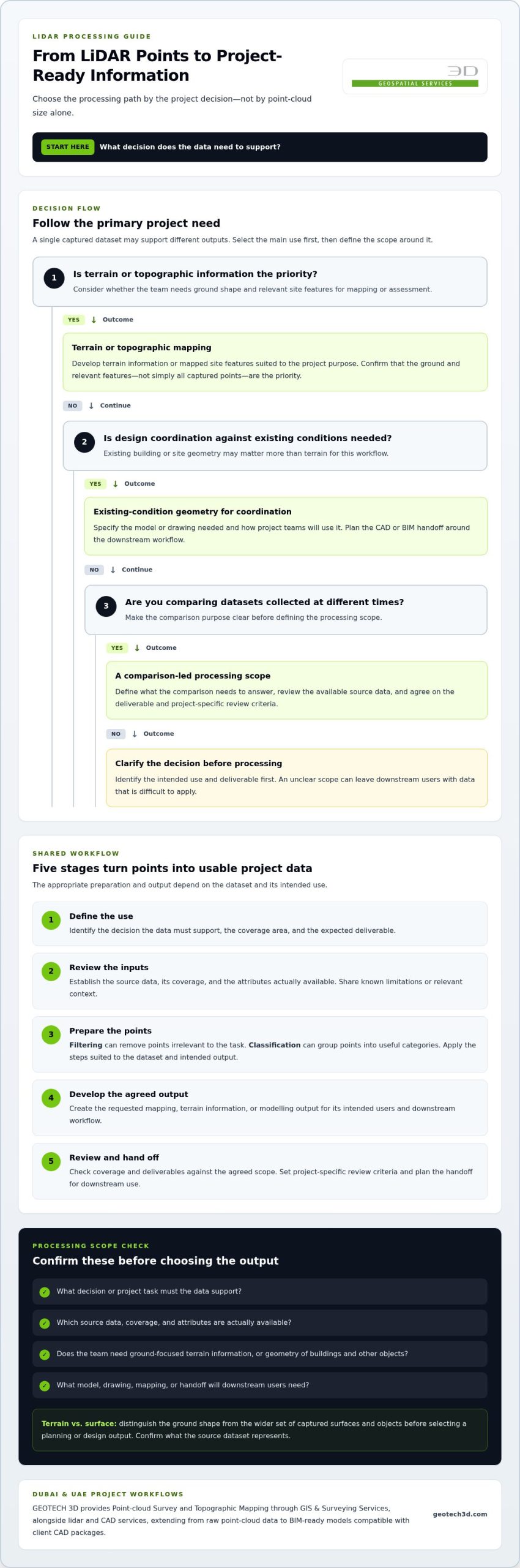
For example, a site dataset may represent both ground and a nearby building. For topographic mapping, the ground shape and relevant site features may be the priority. For design coordination, building geometry may matter more. The same captured data can support different outputs, but the processing needs to reflect the intended use.
When does a project need LiDAR data processing?
Processing is useful when captured points need to be organized for interpretation, review or project use. Survey teams may need terrain information; construction teams may need existing-condition geometry for coordination; and infrastructure or asset teams may need mapped context for planning. These uses call for different scopes and deliverables.
Start by identifying the decision: is the team mapping a site, coordinating a design against existing conditions, or comparing datasets collected at different times? Each purpose can require a different level of organization and modelling. Unnecessary outputs add complexity, while an unclear scope can leave downstream users with data that is difficult to apply.
GEOTECH 3D provides Point-cloud Survey and Topographic Mapping through its GIS & Surveying Services, alongside lidar and CAD services. Its end-to-end capability extends from raw point-cloud data to BIM-ready models compatible with client CAD packages. This connects captured data with defined mapping and modelling workflows.
How the LiDAR Data Processing Workflow Turns Points into Usable Data
A reliable workflow starts with the project decision, not a preset sequence of processing operations. LiDAR data processing services should be scoped around the requested output, available source data and intended users. A terrain product, mapped site and design coordination model can each require different preparation and handoff choices.
From source data review to point-cloud preparation
First, define the purpose, coverage area and expected deliverable. Review the supplied data and its available information, then establish how the output will be used. Preparation may include filtering to remove points that are irrelevant to the task, or classification to group points into useful categories. The dataset and intended output determine which steps are appropriate.
When preparing a brief, describe the area or assets of interest, the source data available and the features the team needs to interpret. If the dataset has known limitations or context, share those details as well. This helps align the processing approach with the actual inputs rather than assumptions about what the data contains.
From processed points to checked project deliverables
Organized data can inform mapping, terrain products or modelling workflows. Plan the handoff around downstream use. For a CAD or BIM workflow, specify the model or drawing needed and how project teams will use it. The U.S. Geological Survey explains how LiDAR data can support high-resolution models of ground elevation, an example of captured data being developed into a defined information product.
Before delivery, review the output against the agreed scope. Check that the requested coverage and deliverables are addressed and that the information is presented for its intended use. Set project-specific review criteria rather than assuming the same checks apply to every dataset.
A practical LiDAR processing workflow:
- 1. Define the use: Identify the decision the data must support.
- 2. Review inputs: Establish the source data, coverage and available attributes.
- 3. Prepare the points: Apply filtering or classification suited to the task.
- 4. Develop the output: Produce the agreed mapping, terrain or modelling information.
- 5. Review and hand off: Check the output against project requirements and plan for downstream use.
This sequence keeps processing decisions tied to project needs instead of producing detail that may not help the next stage. To discuss a project-specific scope in Dubai or elsewhere in the UAE, review GEOTECH 3D’s LiDAR processing services.
Which LiDAR Processing Deliverables Fit Your Project?
The most useful deliverable is the one that supports a defined project task. LiDAR data processing services may produce an organized point cloud, terrain or surface information, mapped outputs, or a model for a downstream workflow. Choose based on the project objective, available source data and agreed scope, rather than requesting every possible output.
| Deliverable | What it represents | Typical project use |
|---|---|---|
| Classified point cloud | Points organized into categories where the data and scope support classification. | Reviewing captured features or using the dataset as a basis for further mapping and analysis. |
| Digital Elevation Model (DEM) | A representation of terrain elevation, generally focused on the ground surface. | Topographic context and terrain assessment for planning or infrastructure work. |
| Digital Surface Model (DSM) | A representation of the upper visible surface, which may include buildings, vegetation and other features. | Understanding surface features and built or natural surroundings. |
| Mapping or model output | Information developed from the point cloud for a defined mapping or modelling purpose. | Topographic mapping, infrastructure planning or design coordination, where included in scope. |
Point clouds, terrain models, and surface models
A classified point cloud groups points into categories to help users interpret the dataset. A DEM focuses on terrain, while a DSM represents the upper visible surface, including features above the ground. The distinction matters: terrain information can support topographic mapping, while surface information can help teams understand buildings or other features in an infrastructure corridor.
LiDAR can help teams examine both natural and manmade environments. Choose the representation according to the question the project needs to answer and the information available in the dataset.
Mapping, change analysis, and BIM-related outputs
Specify mapping or modelling around the intended use and the level of detail downstream users need. Change analysis may be suitable when datasets from different times are available and can be compared for the project purpose. It should be defined as part of the scope, not assumed as a standard output.
GEOTECH 3D provides an end-to-end route from raw point-cloud data to BIM-ready models compatible with client CAD packages. This connects Point-cloud Survey and Topographic Mapping with downstream modelling workflows. Before selecting deliverables, identify who will use them and what decisions they need to support. That keeps the scope practical and relevant.
How to Specify LiDAR Data Processing for Dubai and UAE Projects
A clear scope links captured data to decisions the project team needs to make. For Dubai and UAE projects, define the intended use and delivery workflow before requesting outputs. This helps surveyors, consultants, contractors and asset owners align on what the processed information must support.
Define the project question before requesting outputs
Start with the decision: is the team mapping existing conditions, coordinating a design, modelling an asset or comparing information over time? Identify who will use the result and what they need to do with it. A construction team may need site context for coordination, while an infrastructure team may focus on a route or asset area. Clear expectations help shape a useful processing scope.
Plan data handoffs for UAE project teams
Identify the downstream CAD, BIM or GIS workflow and the teams responsible for using the information. Share project requirements and preferred delivery conventions early. For work on active sites, coordinate access and safety requirements with the relevant project teams, and align data collection and delivery planning with project milestones.
Use this checklist to prepare a project brief for LiDAR data processing services:
- Purpose: State the decision or task the data must support, such as mapping, design coordination or monitoring.
- Coverage: Define the site, corridor or asset area and any relevant boundaries.
- Source data: Describe the available capture data and share its known context or limitations.
- Outputs: Specify the mapping or modelling information required instead of requesting generic processing.
- Downstream users: Identify the teams and CAD, BIM or GIS workflows that will receive and use the deliverables.
- Coordination: Note site access, safety considerations, dependencies and schedule milestones that may affect the work.
These considerations apply across different UAE project environments. Construction teams may need information for site planning; utilities teams may need mapped context for coordination; and oil and gas or infrastructure teams may define requirements around assets, facilities or routes. The appropriate scope depends on the project inputs, intended decisions and handoff needs.
GEOTECH 3D connects Point-cloud Survey and Topographic Mapping with lidar and CAD services, including BIM-ready models compatible with client CAD packages. Sharing the project question, source data and intended users is a practical starting point for a tailored scope.
GEOTECH 3D LiDAR Data Processing: From Point Clouds to Project Use
LiDAR data creates project value when the path from capture to deliverable is clear. In Dubai and across the UAE, GEOTECH 3D connects geospatial data collection with mapping and BIM-related workflows, helping teams define how point-cloud information can support the next project decision.
Connect LiDAR capture, processing, and project deliverables
Drone-based Point-cloud Survey provides captured spatial data for interpretation and project use. The processing depends on the objective: a team seeking mapped site information may need a different output from one coordinating existing conditions with a design workflow. GEOTECH 3D also provides Topographic Mapping through its GIS & Surveying Services.
Capture data is only one part of the work. The project team also needs to establish what information should be developed and how it will be used. GEOTECH 3D’s end-to-end capability extends from raw point-cloud data to BIM-ready models compatible with client CAD packages. This supports a route from captured points towards a model for a downstream design or coordination workflow, with the deliverable defined by the project scope.
Discuss a project-specific processing scope
Good scoping starts with clear inputs. Define the intended use, available source data, area or assets of interest, and outputs required by the people who will use them. Identify whether the priority is mapping, modelling or another project need. These details help align the processing scope with the deliverable.
For Dubai and UAE projects, delivery planning should also account for site access, safety requirements and schedule coordination. GEOTECH 3D emphasizes strict safety compliance, attention to tight schedules and experience across the Middle East. The specific scope is shaped by the assignment and its requirements.
GEOTECH 3D’s LiDAR data processing services connect Point-cloud Survey, Topographic Mapping and BIM-related workflows. Defining objectives and downstream needs early helps establish a clear, technically grounded scope for turning captured information into useful project deliverables.
Turn LiDAR Data into a Clear Project Advantage
Effective LiDAR data processing services begin with the decision your project needs to support. Matching the processing scope to its intended use helps turn captured points into relevant mapping, terrain or modelling information. Clear handoff requirements help downstream teams put those deliverables to work.
For projects in Dubai and across the UAE, GEOTECH 3D connects Point-cloud Survey and Topographic Mapping with an end-to-end capability from raw point-cloud data to BIM-ready models compatible with client CAD packages. Defining your objectives, available source data and required outputs is a practical first step towards a project-specific scope.
A clear purpose and a well-defined handoff make captured data a more useful foundation for planning, coordination and project delivery.
Frequently Asked Questions
What is LiDAR data processing?
LiDAR data processing organizes and interprets captured point-cloud data to create information for a project purpose. Raw capture consists of measured points representing surfaces and objects. Processing can prepare, classify or model that information for tasks such as mapping or design coordination. The appropriate steps depend on the source dataset and intended use. A point cloud alone is not automatically a terrain map or BIM model.
What deliverables can LiDAR data processing produce?
Depending on the project scope and source data, deliverables may include organized point clouds, terrain or surface models, mapping outputs, or models for downstream use. A DEM represents terrain, while a DSM represents the upper visible surface, including features such as buildings or vegetation. Select deliverables by identifying what project teams need to review, plan, coordinate or model.
How does LiDAR data processing work?
The workflow typically starts by defining the project purpose, coverage and required outputs. The source data is reviewed and prepared. Depending on the task, processing may include filtering or classifying points before producing the agreed mapping, terrain or modelling deliverable. The output is then reviewed against project requirements and planned for handoff to its users. The exact steps vary with the dataset and intended use.
What is the difference between a DEM and a DSM?
A Digital Elevation Model (DEM) represents ground terrain, while a Digital Surface Model (DSM) represents the upper surface of the captured area, including features above the ground such as buildings or vegetation. A terrain-focused planning task may need ground elevation, while a review of visible structures may need surface information. The suitable model depends on the project question and available data.
Can LiDAR data be used for BIM and CAD workflows?
Yes. Processed point-cloud information can support BIM or CAD modelling when the project scope calls for it. GEOTECH 3D provides an end-to-end capability from raw point-cloud data to BIM-ready models compatible with client CAD packages. Define the required model and handoff around downstream users and project needs.
How do I scope LiDAR data processing for a project in Dubai?
Begin with the decision the data must support and identify who will use the result. Define the coverage area, available source data, required mapping or modelling outputs, and intended CAD, BIM or GIS workflow. Also plan for site access, safety coordination and relevant schedule milestones. Contact GEOTECH 3D to discuss LiDAR data processing services for your Dubai project.

A point cloud can contain millions of measured points and still leave a project team asking a practical question: what information will help us make the next decision? LiDAR data processing services turn captured data into structured outputs for tasks such as terrain assessment, topographic mapping and modelling.
Unprocessed point clouds can be difficult to interpret, particularly when the intended deliverable or software workflow is unclear. Start with the project purpose: site planning, design coordination, mapping and BIM-related work can each require different outputs. For projects in Dubai and across the UAE, those outputs should also fit the wider surveying, design and construction workflow.
This article explains the main stages of LiDAR processing, how to choose deliverables for common project needs, and what to consider when planning CAD, BIM and GIS handoffs. GEOTECH 3D provides Point-cloud Survey and Topographic Mapping through its GIS & Surveying Services, alongside lidar and CAD services. Its end-to-end capability extends from raw point-cloud data to BIM-ready models compatible with client CAD packages.
Key Takeaways
- Define the project decision first, then set the processing scope and deliverables around it.
- LiDAR data processing can organize captured points into outputs for terrain assessment, mapping or modelling.
- Filtering and classification help structure point-cloud data. The appropriate steps depend on the dataset and intended use.
- Distinguish terrain models from surface models before selecting an output for planning or design.
- GEOTECH 3D connects Point-cloud Survey and Topographic Mapping with BIM-ready models compatible with client CAD packages.
What LiDAR Data Processing Services Do for a Project
LiDAR data processing organizes and interprets captured point-cloud data to create information for a defined project purpose. Capture records measured points. Processing can review and structure them, classify points where appropriate, and develop outputs such as mapped information or models. The scope should follow the decisions the data needs to support, not simply the size of the dataset.
A dense point cloud can show site geometry, but it is not automatically a terrain map, design model or monitoring record. Lidar technology captures distance measurements that represent surfaces and objects. Turning those measurements into project information requires a clear intended use, suitable processing and deliverables that support the next stage of work.
What information does a LiDAR point cloud contain?
Each point represents a measured location in space. Together, points describe surfaces and objects encountered during capture, such as ground, building façades, structures or visible infrastructure. Other attributes depend on the source dataset and capture process, so confirm what information is actually present before defining the processing scope.
For example, a site dataset may represent both ground and a nearby building. For topographic mapping, the ground shape and relevant site features may be the priority. For design coordination, building geometry may matter more. The same captured data can support different outputs, but the processing needs to reflect the intended use.
When does a project need LiDAR data processing?
Processing is useful when captured points need to be organized for interpretation, review or project use. Survey teams may need terrain information; construction teams may need existing-condition geometry for coordination; and infrastructure or asset teams may need mapped context for planning. These uses call for different scopes and deliverables.
Start by identifying the decision: is the team mapping a site, coordinating a design against existing conditions, or comparing datasets collected at different times? Each purpose can require a different level of organization and modelling. Unnecessary outputs add complexity, while an unclear scope can leave downstream users with data that is difficult to apply.
GEOTECH 3D provides Point-cloud Survey and Topographic Mapping through its GIS & Surveying Services, alongside lidar and CAD services. Its end-to-end capability extends from raw point-cloud data to BIM-ready models compatible with client CAD packages. This connects captured data with defined mapping and modelling workflows.
How the LiDAR Data Processing Workflow Turns Points into Usable Data
A reliable workflow starts with the project decision, not a preset sequence of processing operations. LiDAR data processing services should be scoped around the requested output, available source data and intended users. A terrain product, mapped site and design coordination model can each require different preparation and handoff choices.
From source data review to point-cloud preparation
First, define the purpose, coverage area and expected deliverable. Review the supplied data and its available information, then establish how the output will be used. Preparation may include filtering to remove points that are irrelevant to the task, or classification to group points into useful categories. For teams managing massive datasets in-house, high-performance GPU and AI infrastructure from E-Circles LLC can help support the intensive compute requirements of point-cloud processing. The dataset and intended output determine which steps are appropriate.
When preparing a brief, describe the area or assets of interest, the source data available and the features the team needs to interpret. If the dataset has known limitations or context, share those details as well. This helps align the processing approach with the actual inputs rather than assumptions about what the data contains.
From processed points to checked project deliverables
Organized data can inform mapping, terrain products or modelling workflows. Plan the handoff around downstream use. For a CAD or BIM workflow, specify the model or drawing needed and how project teams will use it. The U.S. Geological Survey explains how LiDAR data can support high-resolution models of ground elevation, an example of captured data being developed into a defined information product.
Before delivery, review the output against the agreed scope. Check that the requested coverage and deliverables are addressed and that the information is presented for its intended use. Set project-specific review criteria rather than assuming the same checks apply to every dataset.
A practical LiDAR processing workflow:
- 1. Define the use: Identify the decision the data must support.
- 2. Review inputs: Establish the source data, coverage and available attributes.
- 3. Prepare the points: Apply filtering or classification suited to the task.
- 4. Develop the output: Produce the agreed mapping, terrain or modelling information.
- 5. Review and hand off: Check the output against project requirements and plan for downstream use.
This sequence keeps processing decisions tied to project needs instead of producing detail that may not help the next stage. To discuss a project-specific scope in Dubai or elsewhere in the UAE, review GEOTECH 3D’s LiDAR processing services.
Which LiDAR Processing Deliverables Fit Your Project?
The most useful deliverable is the one that supports a defined project task. LiDAR data processing services may produce an organized point cloud, terrain or surface information, mapped outputs, or a model for a downstream workflow. Choose based on the project objective, available source data and agreed scope, rather than requesting every possible output.
| Deliverable | What it represents | Typical project use |
|---|---|---|
| Classified point cloud | Points organized into categories where the data and scope support classification. | Reviewing captured features or using the dataset as a basis for further mapping and analysis. |
| Digital Elevation Model (DEM) | A representation of terrain elevation, generally focused on the ground surface. | Topographic context and terrain assessment for planning or infrastructure work. |
| Digital Surface Model (DSM) | A representation of the upper visible surface, which may include buildings, vegetation and other features. | Understanding surface features and built or natural surroundings. |
| Mapping or model output | Information developed from the point cloud for a defined mapping or modelling purpose. | Topographic mapping, infrastructure planning or design coordination, where included in scope. |
Point clouds, terrain models, and surface models
A classified point cloud groups points into categories to help users interpret the dataset. A DEM focuses on terrain, while a DSM represents the upper visible surface, including features above the ground. The distinction matters: terrain information can support topographic mapping, while surface information can help teams understand buildings or other features in an infrastructure corridor.
LiDAR can help teams examine both natural and manmade environments. Choose the representation according to the question the project needs to answer and the information available in the dataset.
Mapping, change analysis, and BIM-related outputs
Specify mapping or modelling around the intended use and the level of detail downstream users need. Change analysis may be suitable when datasets from different times are available and can be compared for the project purpose. It should be defined as part of the scope, not assumed as a standard output.
GEOTECH 3D provides an end-to-end route from raw point-cloud data to BIM-ready models compatible with client CAD packages. This connects Point-cloud Survey and Topographic Mapping with downstream modelling workflows. Before selecting deliverables, identify who will use them and what decisions they need to support. That keeps the scope practical and relevant.
How to Specify LiDAR Data Processing for Dubai and UAE Projects
A clear scope links captured data to decisions the project team needs to make. For Dubai and UAE projects, define the intended use and delivery workflow before requesting outputs. This helps surveyors, consultants, contractors and asset owners align on what the processed information must support.
Define the project question before requesting outputs
Start with the decision: is the team mapping existing conditions, coordinating a design, modelling an asset or comparing information over time? Identify who will use the result and what they need to do with it. A construction team may need site context for coordination, while an infrastructure team may focus on a route or asset area. Clear expectations help shape a useful processing scope.
Plan data handoffs for UAE project teams
Identify the downstream CAD, BIM or GIS workflow and the teams responsible for using the information. Share project requirements and preferred delivery conventions early. For work on active sites, coordinate access and safety requirements with the relevant project teams, and align data collection and delivery planning with project milestones.
Use this checklist to prepare a project brief for LiDAR data processing services:
- Purpose: State the decision or task the data must support, such as mapping, design coordination or monitoring.
- Coverage: Define the site, corridor or asset area and any relevant boundaries.
- Source data: Describe the available capture data and share its known context or limitations.
- Outputs: Specify the mapping or modelling information required instead of requesting generic processing.
- Downstream users: Identify the teams and CAD, BIM or GIS workflows that will receive and use the deliverables.
- Coordination: Note site access, safety considerations, dependencies and schedule milestones that may affect the work.
These considerations apply across different UAE project environments. Construction teams may need information for site planning; utilities teams may need mapped context for coordination; and oil and gas or infrastructure teams may define requirements around assets, facilities or routes. The appropriate scope depends on the project inputs, intended decisions and handoff needs.
GEOTECH 3D connects Point-cloud Survey and Topographic Mapping with lidar and CAD services, including BIM-ready models compatible with client CAD packages. Sharing the project question, source data and intended users is a practical starting point for a tailored scope.
GEOTECH 3D LiDAR Data Processing: From Point Clouds to Project Use
LiDAR data creates project value when the path from capture to deliverable is clear. In Dubai and across the UAE, GEOTECH 3D connects geospatial data collection with mapping and BIM-related workflows, helping teams define how point-cloud information can support the next project decision.
Connect LiDAR capture, processing, and project deliverables
Drone-based Point-cloud Survey provides captured spatial data for interpretation and project use. The processing depends on the objective: a team seeking mapped site information may need a different output from one coordinating existing conditions with a design workflow. GEOTECH 3D also provides Topographic Mapping through its GIS & Surveying Services.
Capture data is only one part of the work. The project team also needs to establish what information should be developed and how it will be used. GEOTECH 3D’s end-to-end capability extends from raw point-cloud data to BIM-ready models compatible with client CAD packages. This supports a route from captured points towards a model for a downstream design or coordination workflow, with the deliverable defined by the project scope.
Discuss a project-specific processing scope
Good scoping starts with clear inputs. Define the intended use, available source data, area or assets of interest, and outputs required by the people who will use them. Identify whether the priority is mapping, modelling or another project need. These details help align the processing scope with the deliverable.
For Dubai and UAE projects, delivery planning should also account for site access, safety requirements and schedule coordination. GEOTECH 3D emphasizes strict safety compliance, attention to tight schedules and experience across the Middle East. The specific scope is shaped by the assignment and its requirements.
GEOTECH 3D’s LiDAR data processing services connect Point-cloud Survey, Topographic Mapping and BIM-related workflows. Defining objectives and downstream needs early helps establish a clear, technically grounded scope for turning captured information into useful project deliverables.
Turn LiDAR Data into a Clear Project Advantage
Effective LiDAR data processing services begin with the decision your project needs to support. Matching the processing scope to its intended use helps turn captured points into relevant mapping, terrain or modelling information. Clear handoff requirements help downstream teams put those deliverables to work.
For projects in Dubai and across the UAE, GEOTECH 3D connects Point-cloud Survey and Topographic Mapping with an end-to-end capability from raw point-cloud data to BIM-ready models compatible with client CAD packages. Defining your objectives, available source data and required outputs is a practical first step towards a project-specific scope.
A clear purpose and a well-defined handoff make captured data a more useful foundation for planning, coordination and project delivery.
Frequently Asked Questions
What is LiDAR data processing?
LiDAR data processing organizes and interprets captured point-cloud data to create information for a project purpose. Raw capture consists of measured points representing surfaces and objects. Processing can prepare, classify or model that information for tasks such as mapping or design coordination. The appropriate steps depend on the source dataset and intended use. A point cloud alone is not automatically a terrain map or BIM model.
What deliverables can LiDAR data processing produce?
Depending on the project scope and source data, deliverables may include organized point clouds, terrain or surface models, mapping outputs, or models for downstream use. A DEM represents terrain, while a DSM represents the upper visible surface, including features such as buildings or vegetation. Select deliverables by identifying what project teams need to review, plan, coordinate or model.
How does LiDAR data processing work?
The workflow typically starts by defining the project purpose, coverage and required outputs. The source data is reviewed and prepared. Depending on the task, processing may include filtering or classifying points before producing the agreed mapping, terrain or modelling deliverable. The output is then reviewed against project requirements and planned for handoff to its users. The exact steps vary with the dataset and intended use.
What is the difference between a DEM and a DSM?
A Digital Elevation Model (DEM) represents ground terrain, while a Digital Surface Model (DSM) represents the upper surface of the captured area, including features above the ground such as buildings or vegetation. A terrain-focused planning task may need ground elevation, while a review of visible structures may need surface information. The suitable model depends on the project question and available data.
Can LiDAR data be used for BIM and CAD workflows?
Yes. Processed point-cloud information can support BIM or CAD modelling when the project scope calls for it. GEOTECH 3D provides an end-to-end capability from raw point-cloud data to BIM-ready models compatible with client CAD packages. Define the required model and handoff around downstream users and project needs.
How do I scope LiDAR data processing for a project in Dubai?
Begin with the decision the data must support and identify who will use the result. Define the coverage area, available source data, required mapping or modelling outputs, and intended CAD, BIM or GIS workflow. Also plan for site access, safety coordination and relevant schedule milestones. Contact GEOTECH 3D to discuss LiDAR data processing services for your Dubai project.
Search Now
Error: Contact form not found.