

Our Services
Drone Inspection Buy-In: A Guide for Project Teams
What if the strongest case for a drone inspection has little to do with the drone itself? To understand how to get buy-in for drone inspections, start with the project decision the inspection needs to support. That could mean assessing a façade, checking solar panels, or reviewing potential asset anomalies. Stakeholders are more likely to engage when the proposed method addresses an operational need and produces evidence the team can use.
It’s reasonable to ask how the work will address safety, data quality, site requirements, disruption, and cost. A credible proposal answers those questions with a defined scope and a clear explanation of how the findings will be used. For projects in Dubai and across the UAE, include site-specific operating requirements in the planning process from the outset.
This guide explains how to build an evidence-led case around inspection needs, stakeholder priorities, and practical implementation. GEOTECH 3D’s Drone Services include High-resolution Inspection and integrated visual and thermal inspections for relevant asset questions. The goal is to align the team on a manageable next step: a clearly scoped inspection.
Key Takeaways
- Start with the project or asset question the inspection must answer, then connect the evidence to a clear operational decision.
- Learn how to get buy-in for drone inspections by mapping each proposed output to its intended use and the team responsible for acting on it.
- Give stakeholders a practical way to assess safety, access, data quality, compliance, and potential disruption before approval.
- Turn stakeholder questions into a focused plan that defines the target asset, inspection area, deliverables, and decision to be supported.
- See how GEOTECH 3D’s Drone Services, including High-resolution Inspection, Thermal Inspection, and Façade Inspection, can align with an approved scope in Dubai and the UAE.
How to Get Buy-In for Drone Inspections by Starting With the Project Problem
A drone inspection proposal is easier to assess when it begins with a defined project or asset problem. The goal isn’t to introduce technology for its own sake. Explain what information is missing, which decision depends on it, and why a drone inspection is a suitable way to collect the evidence. That is the practical starting point for how to get buy-in for drone inspections.
Keep the method secondary to the need. A drone is an Unmanned aerial vehicle (UAV), but the approval discussion should focus on the inspection scope and its intended use. GEOTECH 3D’s Drone Services include High-resolution Inspection, which can be considered when visual evidence is needed for a defined project question.
Which inspection problem is important enough to address?
Define the asset, its location, the condition or uncertainty to investigate, and when the evidence is needed. For example, a team might assess a façade before planning maintenance, examine solar panels for potential anomalies, or inspect a confined space or shaft above a ceiling where visibility is limited.
Distinguish a specific inspection need from routine documentation. General site progress records may be useful, but a targeted proposal explains what is unknown and what the team will decide after reviewing the evidence. A precise question makes it easier to set a proportionate scope and avoid collecting information that has no clear use.
Problem-to-decision statement: “We need to inspect [asset and location] to understand [condition or uncertainty] by [decision deadline], so [responsible team] can decide [next action].” Use this sentence to keep the approval discussion focused on the project outcome.
Who needs to support a drone inspection proposal?
Identify the people who will sponsor, review, enable, or use the inspection. Depending on the project, this may include a project sponsor, engineering, operations, project management, and safety stakeholders. Map the roles and decision process for the specific project instead of assuming every organization follows the same approval structure.
Different stakeholders may assess the proposal against different priorities. A sponsor may need to understand how the evidence supports a project decision. Engineering may focus on whether the outputs answer the technical question. Operations may consider access and asset impact, while project management and safety stakeholders may need details about scope, timing, and site conditions.
Bring those perspectives together around one shared question: what decision will the inspection evidence help the team make? That keeps the proposal grounded in project need and gives the business case a clear direction.
Build the Drone Inspection Business Case Around Evidence and Project Value
Once the project question is defined, explain why the information gap matters. Show which decision is delayed or difficult without inspection evidence and what the project team needs to understand before choosing a next step. Base the case on documented project conditions, not assumed savings or broad claims that drones are always faster, safer, or more cost-effective.
A useful drone inspection business case connects a defined information gap to specific evidence, a responsible decision-maker, and an operational decision.
Connect inspection outputs to decisions
For each proposed output, state the question it can help address, who will use it, and how it informs the decision. GEOTECH 3D’s integrated visual and thermal inspections can support asset reviews. Thermal observations may help identify anomalies or cold spots, while visual data provides imagery for review. These are observations for assessment, not an automatic engineering diagnosis. Separate what was recorded from any interpretation that requires technical review.
A point-cloud survey may be relevant when a decision depends on spatial information about an asset or area. Progress Monitoring may suit a project where the team needs to review development over time. Include these outputs only when they serve the defined need, rather than adding deliverables simply because they are available.
- Output: visual or thermal observations. Use: review a defined asset condition. Decision owner: the relevant engineering or asset team.
- Output: point-cloud survey or progress information, if required. Use: assess spatial conditions or project status. Decision owner: the project team responsible for the next action.
Present value without unsupported ROI claims
Compare the proposed drone inspection with the current method using project-specific criteria. Record the inspection area, access needs, required evidence, site constraints, decision timing, and known impacts on surrounding work. A conventional access method may still suit some scopes. Explain why the proposed approach fits this project rather than claiming it is universally superior.
Make assumptions visible. Separate confirmed project inputs from estimates and items that still need review. This gives stakeholders a fair basis for comparing options and makes it easier to refine the case if the scope changes. For project-specific Drone Services, keep the discussion centred on the evidence required and the decision it will support.
Address Safety, Data Quality, and Compliance Concerns Before They Block Approval
Approval depends on more than the inspection objective. Project teams also need to understand how the work fits the site, how safety concerns will be addressed, and whether the data will answer the agreed question. Treat these as core planning topics, not objections to dismiss. Addressing them early makes how to get buy-in for drone inspections a more structured discussion.
Assess safety and site constraints
Consider the inspection area in relation to access points, occupied spaces, nearby operations, and other site activities. A façade inspection at an active development, for example, may require coordination with nearby teams. A confined-space or shaft inspection involves different access and operational considerations. Plan for the actual site hazards and project safety requirements instead of assuming one approach suits every location.
Operating requirements must be checked against the project location and conditions. In Dubai and elsewhere in the UAE, do not assume that permissions or operating arrangements for one site apply to another. Identify what needs verification for the specific location and scope before finalising the inspection plan.
| Approval concern | Evidence or information to prepare | Relevant stakeholders |
|---|---|---|
| Site safety and access | Inspection area, access conditions, identified hazards, and site coordination needs | Safety, operations, and project management |
| Compliance and operating requirements | Project location, proposed activity, and confirmation of applicable requirements | Project sponsor, safety, and relevant site representatives |
| Data quality and scope | Required visual or thermal evidence, target areas, and intended use | Engineering and the team making the asset decision |
| Disruption to site activity | Work area, planned coordination, and potential interaction with ongoing operations | Operations and project management |
Define what makes the inspection data useful
Specify the evidence needed before planning data capture. A High-resolution Inspection may suit a question about visible asset condition. Thermal Inspection can provide thermal observations for review when heat patterns are relevant. GEOTECH 3D provides integrated visual and thermal inspections, allowing teams to examine an asset question using complementary data where appropriate.
Scope affects usefulness. Identify the target areas, required observations, and conditions that could limit what can be captured. Then connect each output to its intended review. Drone data can record observations, including potential anomalies or cold spots, but those observations need appropriate technical interpretation. Keep recorded evidence distinct from an engineering conclusion.
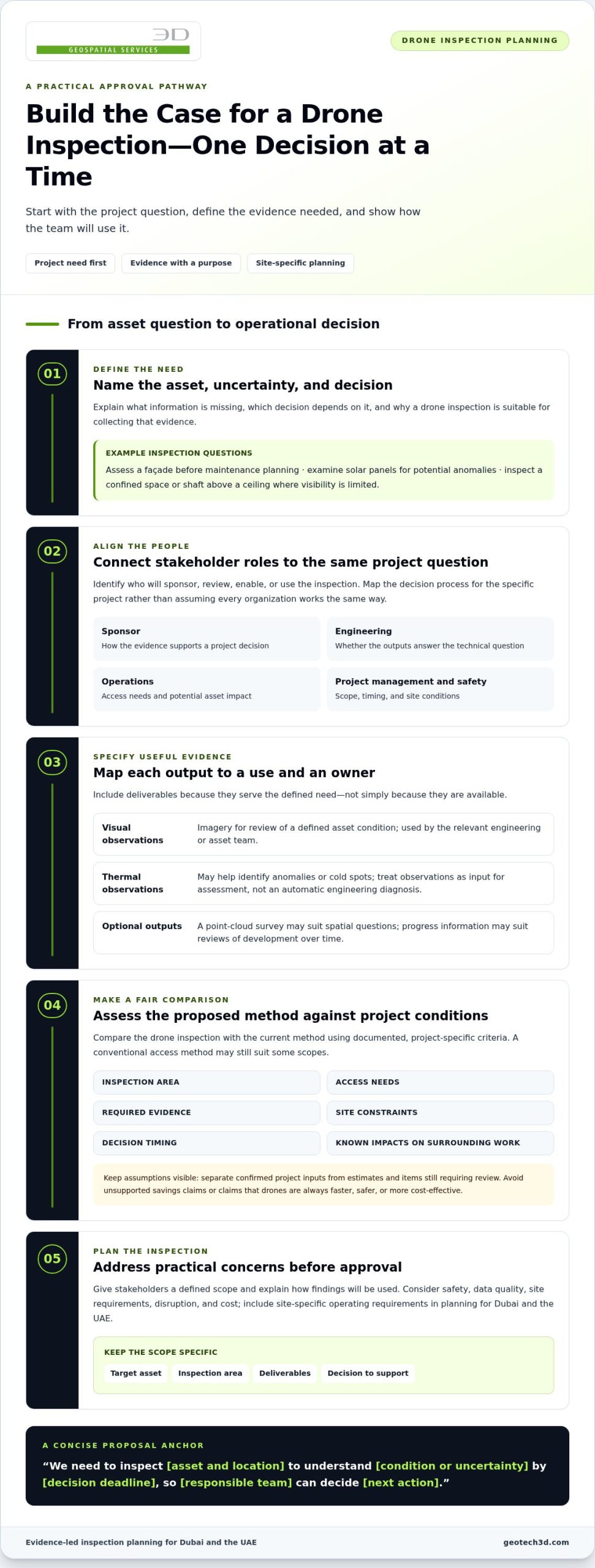
How to Turn Stakeholder Questions Into a Clear Drone Inspection Plan
Convert discussion into a plan people can review, assign, and act on. A clear sequence helps answer how to get buy-in for drone inspections without letting the proposal expand into an undefined data-gathering exercise.
- Define the question. State what the team needs to know and which project or asset decision depends on the answer.
- Identify stakeholders. Name the sponsor, technical reviewers, site contacts, and decision-makers relevant to this project. Assign roles based on the organization’s actual approval process.
- Scope the evidence. Specify the inspection type and outputs required to address the question. Exclude data that has no defined use.
- Review constraints. Document access, site coordination, safety planning, and applicable operating requirements that need review for the location and conditions.
- Agree on next steps. Confirm who will coordinate the inspection, review the results, and decide what action follows.
What should an inspection proposal specify?
Make the scope concrete enough to prevent ambiguity. Identify the target asset and location, inspection area, inspection type, intended outputs, and project decision those outputs will inform. Assign responsibility for coordinating site access, reviewing the results, and acting on findings. Keep the requested outputs proportionate to the question, whether the scope calls for visual evidence, thermal observations, or another relevant deliverable.
A concise approval brief can bring the proposal together in one place:
- Purpose, target asset, and inspection boundaries
- Proposed inspection and required outputs
- Stakeholder responsibilities and review pathway
- Site coordination and safety planning considerations
- Confirmed project facts, open assumptions, and decisions required
How can a project team reduce approval friction?
Prepare direct answers to likely questions before the approval meeting. What is included in the scope? Who will coordinate access? What will the team receive, and who will interpret the findings? Which site or compliance assumptions still need review? Separating confirmed information from open items helps stakeholders assess the proposal without treating assumptions as settled facts.
If a broader proposal feels difficult to approve, consider a limited inspection with a defined area, output, and decision. This gives the team a manageable way to assess whether the evidence addresses the original question before considering a wider scope. If the inspection data may contribute to broader asset workflows, consider how it could fit alongside the principles discussed in Digital Twin for Asset Lifecycle: Comprehensive 2026 Guide.
Explore GEOTECH 3D Drone Services to see how inspection outputs can be scoped around a project need.
Move From Approval to a Dubai Drone Inspection With GEOTECH 3D
Once the inspection question, outputs, and stakeholder responsibilities are agreed, match the approved scope to a suitable service. GEOTECH 3D’s Drone Services are planned around the asset and the evidence the project team needs. A focused scope gives the team a practical basis for coordinating the work and reviewing its results.
Match GEOTECH 3D Drone Services to the approved inspection question
Choose the inspection type according to the asset question. High-resolution Inspection can support a need for detailed visual evidence, while Thermal Inspection provides thermal observations for review. For building-envelope concerns, Façade Inspection is aligned with the target asset. GEOTECH 3D also provides integrated thermal and visual inspections, so both types of evidence can be considered when they fit the scope.
The DJI Zenmuse H20T is a multi-sensor payload used in GEOTECH 3D’s inspection work. Determine the proposed deliverables from the approved question, target areas, and intended use of the findings. This keeps the review focused on project evidence rather than equipment specifications. Explore the GEOTECH 3D services overview for more on the company’s surveying and geospatial capabilities.
Prepare for the next project discussion
Bring the asset location, inspection objective, and known site constraints into the project discussion. Specify the target area, the output stakeholders need, who will coordinate site access, and who will review the results. This gives the scope an operational purpose and helps the team identify unresolved requirements before planning proceeds.
For a Dubai or UAE site, include safety requirements, operating considerations, and project schedules in the planning discussion. Verify applicable permissions and operating requirements for the specific location and conditions rather than making assumptions. State how the results will be used, whether to inform an asset review, support project planning, or guide further technical assessment.
That project-specific approach is central to how to get buy-in for drone inspections: make the intended evidence, responsibilities, and next decision clear. GEOTECH 3D can discuss your project requirements and shape a Drone Services scope around the inspection need.
Make Your Next Inspection Decision With Confidence
A strong case for drone inspection starts with a defined asset question and ends with evidence that supports a project decision. To understand how to get buy-in for drone inspections, connect proposed outputs to stakeholder priorities, identify site and compliance considerations early, and keep the scope focused on what the team needs to know.
GEOTECH 3D’s Drone Services include High-resolution Inspection, Thermal Inspection, and Progress Monitoring. Integrated thermal and visual inspections can help teams review asset observations, with the scope planned around site safety requirements and project schedules. Clear objectives and responsibilities give stakeholders a practical basis for moving from discussion to an inspection plan.
Bring your project requirements, target asset, and known site constraints into the next conversation. A focused discussion can help align the inspection scope with the evidence your team needs.
With the right question guiding the work, your team can take the next step with clarity and confidence.
Frequently Asked Questions
How do you convince management to approve drone inspections?
Present the inspection as a response to a defined asset or project need, not as a technology trial. State what is unknown, which decision depends on the evidence, and how the proposed outputs will support that decision. To explain how to get buy-in for drone inspections, prepare a focused scope, identify the responsible reviewers, and address safety, access, data requirements, and assumptions before seeking approval.
What are the main benefits of drone inspections for project teams?
Drone inspections can provide visual or thermal evidence for defined asset questions. Integrated drone-based thermal and visual inspections can also help identify anomalies, cold spots, and internal damage without ground personnel. The practical value depends on the site, scope, and intended use of the data. GEOTECH 3D’s Drone Services include High-resolution Inspection, Thermal Inspection, and Progress Monitoring, which can support asset review or project monitoring when matched to the team’s requirements.
How do you calculate the ROI of a drone inspection?
Use project-specific inputs rather than a general savings claim. Compare the proposed inspection with the current method, accounting for scope, access needs, project coordination, decision timing, and the costs associated with each approach. Then assess the value of resolving the information gap, such as enabling a timely asset review. Record assumptions separately from confirmed inputs so stakeholders can review the calculation transparently.
Are drone inspections safe for construction and industrial sites?
Safety depends on the inspection plan and site conditions. Review access, occupied areas, nearby operations, hazards, and coordination requirements with the relevant project and safety stakeholders. Plan the inspection around site-specific controls and applicable operating requirements, rather than treating it as inherently safe because it uses a drone. For Dubai and UAE projects, verify relevant permissions and requirements for the specific location and scope before planning operations.
What information should a drone inspection proposal include?
A useful proposal identifies the target asset and location, inspection area, inspection type, required outputs, and the decision the evidence will inform. It should also name who will coordinate site access, review the results, and act on findings. Include safety and site coordination considerations, applicable requirements to verify, decision timing, and open assumptions. Keep deliverables aligned with the project question rather than requesting data without a defined use.
Can drone inspections provide thermal and visual information?
Yes. GEOTECH 3D provides integrated drone-based thermal and visual inspections. Visual evidence can document observable asset conditions, while thermal observations can help identify patterns such as anomalies or cold spots for technical review. The inspection scope should specify the areas and questions to address. Captured observations are evidence for assessment, not an automatic engineering diagnosis, so interpretation should follow the project’s appropriate technical review process.
How do you choose between drone inspections and conventional inspection methods?
Compare methods against the project’s actual requirements rather than assuming one is always preferable. Consider the asset, inspection area, access needs, site activity, safety planning, evidence required, and timing of the decision. A drone approach may suit a scope requiring visual or thermal data from areas that are difficult to assess directly. Conventional methods may better meet other needs. Document the reasons for the selected approach and its limitations.
What should UAE project teams check before planning a drone inspection?
UAE project teams should define the asset and inspection objective, identify site access and safety constraints, and coordinate with the people responsible for operations and technical review. They should also verify applicable permissions and operating requirements against the specific project location and conditions. Requirements may differ across sites. Include the planned outputs, intended use, schedule considerations, and any unresolved assumptions in the inspection brief.

What if the strongest case for a drone inspection has little to do with the drone itself? To understand how to get buy-in for drone inspections, start with the project decision the inspection needs to support. That could mean assessing a façade, checking solar panels, or reviewing potential asset anomalies. Stakeholders are more likely to engage when the proposed method addresses an operational need and produces evidence the team can use.
It’s reasonable to ask how the work will address safety, data quality, site requirements, disruption, and cost. A credible proposal answers those questions with a defined scope and a clear explanation of how the findings will be used. For projects in Dubai and across the UAE, include site-specific operating requirements in the planning process from the outset.
This guide explains how to build an evidence-led case around inspection needs, stakeholder priorities, and practical implementation. GEOTECH 3D’s Drone Services include High-resolution Inspection and integrated visual and thermal inspections for relevant asset questions. The goal is to align the team on a manageable next step: a clearly scoped inspection.
Key Takeaways
- Start with the project or asset question the inspection must answer, then connect the evidence to a clear operational decision.
- Learn how to get buy-in for drone inspections by mapping each proposed output to its intended use and the team responsible for acting on it.
- Give stakeholders a practical way to assess safety, access, data quality, compliance, and potential disruption before approval.
- Turn stakeholder questions into a focused plan that defines the target asset, inspection area, deliverables, and decision to be supported.
- See how GEOTECH 3D’s Drone Services, including High-resolution Inspection, Thermal Inspection, and Façade Inspection, can align with an approved scope in Dubai and the UAE.
How to Get Buy-In for Drone Inspections by Starting With the Project Problem
A drone inspection proposal is easier to assess when it begins with a defined project or asset problem. The goal isn’t to introduce technology for its own sake. Explain what information is missing, which decision depends on it, and why a drone inspection is a suitable way to collect the evidence. That is the practical starting point for how to get buy-in for drone inspections.
Keep the method secondary to the need. A drone is an Unmanned aerial vehicle (UAV), but the approval discussion should focus on the inspection scope and its intended use. GEOTECH 3D’s Drone Services include High-resolution Inspection, which can be considered when visual evidence is needed for a defined project question.
Which inspection problem is important enough to address?
Define the asset, its location, the condition or uncertainty to investigate, and when the evidence is needed. For example, a team might assess a façade before planning maintenance, examine solar panels for potential anomalies, or inspect a confined space or shaft above a ceiling where visibility is limited.
Distinguish a specific inspection need from routine documentation. General site progress records may be useful, but a targeted proposal explains what is unknown and what the team will decide after reviewing the evidence. A precise question makes it easier to set a proportionate scope and avoid collecting information that has no clear use.
Problem-to-decision statement: “We need to inspect [asset and location] to understand [condition or uncertainty] by [decision deadline], so [responsible team] can decide [next action].” Use this sentence to keep the approval discussion focused on the project outcome.
Who needs to support a drone inspection proposal?
Identify the people who will sponsor, review, enable, or use the inspection. Depending on the project, this may include a project sponsor, engineering, operations, project management, and safety stakeholders. Map the roles and decision process for the specific project instead of assuming every organization follows the same approval structure.
Different stakeholders may assess the proposal against different priorities. A sponsor may need to understand how the evidence supports a project decision. Engineering may focus on whether the outputs answer the technical question. Operations may consider access and asset impact, while project management and safety stakeholders may need details about scope, timing, and site conditions.
Bring those perspectives together around one shared question: what decision will the inspection evidence help the team make? That keeps the proposal grounded in project need and gives the business case a clear direction.
Build the Drone Inspection Business Case Around Evidence and Project Value
Once the project question is defined, explain why the information gap matters. Show which decision is delayed or difficult without inspection evidence and what the project team needs to understand before choosing a next step. Base the case on documented project conditions, not assumed savings or broad claims that drones are always faster, safer, or more cost-effective.
A useful drone inspection business case connects a defined information gap to specific evidence, a responsible decision-maker, and an operational decision.
Connect inspection outputs to decisions
For each proposed output, state the question it can help address, who will use it, and how it informs the decision. GEOTECH 3D’s integrated visual and thermal inspections can support asset reviews. Thermal observations may help identify anomalies or cold spots, while visual data provides imagery for review. These are observations for assessment, not an automatic engineering diagnosis. Separate what was recorded from any interpretation that requires technical review.
A point-cloud survey may be relevant when a decision depends on spatial information about an asset or area. Progress Monitoring may suit a project where the team needs to review development over time. Include these outputs only when they serve the defined need, rather than adding deliverables simply because they are available.
- Output: visual or thermal observations. Use: review a defined asset condition. Decision owner: the relevant engineering or asset team.
- Output: point-cloud survey or progress information, if required. Use: assess spatial conditions or project status. Decision owner: the project team responsible for the next action.
Present value without unsupported ROI claims
Compare the proposed drone inspection with the current method using project-specific criteria. Record the inspection area, access needs, required evidence, site constraints, decision timing, and known impacts on surrounding work. A conventional access method may still suit some scopes. Explain why the proposed approach fits this project rather than claiming it is universally superior.
Make assumptions visible. Separate confirmed project inputs from estimates and items that still need review. This gives stakeholders a fair basis for comparing options and makes it easier to refine the case if the scope changes. For project-specific Drone Services, keep the discussion centred on the evidence required and the decision it will support.
Address Safety, Data Quality, and Compliance Concerns Before They Block Approval
Approval depends on more than the inspection objective. Project teams also need to understand how the work fits the site, how safety concerns will be addressed, and whether the data will answer the agreed question. Treat these as core planning topics, not objections to dismiss. Addressing them early makes how to get buy-in for drone inspections a more structured discussion.
Assess safety and site constraints
Consider the inspection area in relation to access points, occupied spaces, nearby operations, and other site activities. A façade inspection at an active development, for example, may require coordination with nearby teams. A confined-space or shaft inspection involves different access and operational considerations. Plan for the actual site hazards and project safety requirements instead of assuming one approach suits every location.
Operating requirements must be checked against the project location and conditions. In Dubai and elsewhere in the UAE, do not assume that permissions or operating arrangements for one site apply to another. Identify what needs verification for the specific location and scope before finalising the inspection plan.
| Approval concern | Evidence or information to prepare | Relevant stakeholders |
|---|---|---|
| Site safety and access | Inspection area, access conditions, identified hazards, and site coordination needs | Safety, operations, and project management |
| Compliance and operating requirements | Project location, proposed activity, and confirmation of applicable requirements | Project sponsor, safety, and relevant site representatives |
| Data quality and scope | Required visual or thermal evidence, target areas, and intended use | Engineering and the team making the asset decision |
| Disruption to site activity | Work area, planned coordination, and potential interaction with ongoing operations | Operations and project management |
Define what makes the inspection data useful
Specify the evidence needed before planning data capture. A High-resolution Inspection may suit a question about visible asset condition. Thermal Inspection can provide thermal observations for review when heat patterns are relevant. GEOTECH 3D provides integrated visual and thermal inspections, allowing teams to examine an asset question using complementary data where appropriate.
Scope affects usefulness. Identify the target areas, required observations, and conditions that could limit what can be captured. Then connect each output to its intended review. Drone data can record observations, including potential anomalies or cold spots, but those observations need appropriate technical interpretation. Keep recorded evidence distinct from an engineering conclusion.
How to Turn Stakeholder Questions Into a Clear Drone Inspection Plan
Convert discussion into a plan people can review, assign, and act on. A clear sequence helps answer how to get buy-in for drone inspections without letting the proposal expand into an undefined data-gathering exercise.
- Define the question. State what the team needs to know and which project or asset decision depends on the answer.
- Identify stakeholders. Name the sponsor, technical reviewers, site contacts, and decision-makers relevant to this project. Assign roles based on the organization’s actual approval process.
- Scope the evidence. Specify the inspection type and outputs required to address the question. Exclude data that has no defined use.
- Review constraints. Document access, site coordination, safety planning, and applicable operating requirements that need review for the location and conditions.
- Agree on next steps. Confirm who will coordinate the inspection, review the results, and decide what action follows.
What should an inspection proposal specify?
Make the scope concrete enough to prevent ambiguity. Identify the target asset and location, inspection area, inspection type, intended outputs, and project decision those outputs will inform. Assign responsibility for coordinating site access, reviewing the results, and acting on findings. Keep the requested outputs proportionate to the question, whether the scope calls for visual evidence, thermal observations, or another relevant deliverable.
A concise approval brief can bring the proposal together in one place:
- Purpose, target asset, and inspection boundaries
- Proposed inspection and required outputs
- Stakeholder responsibilities and review pathway
- Site coordination and safety planning considerations
- Confirmed project facts, open assumptions, and decisions required
How can a project team reduce approval friction?
Prepare direct answers to likely questions before the approval meeting. What is included in the scope? Who will coordinate access? What will the team receive, and who will interpret the findings? Which site or compliance assumptions still need review? Separating confirmed information from open items helps stakeholders assess the proposal without treating assumptions as settled facts.
If a broader proposal feels difficult to approve, consider a limited inspection with a defined area, output, and decision. This gives the team a manageable way to assess whether the evidence addresses the original question before considering a wider scope. If the inspection data may contribute to broader asset workflows, consider how it could fit alongside the principles discussed in Digital Twin for Asset Lifecycle: Comprehensive 2026 Guide.
Explore GEOTECH 3D Drone Services to see how inspection outputs can be scoped around a project need.
Move From Approval to a Dubai Drone Inspection With GEOTECH 3D
Once the inspection question, outputs, and stakeholder responsibilities are agreed, match the approved scope to a suitable service. GEOTECH 3D’s Drone Services are planned around the asset and the evidence the project team needs. A focused scope gives the team a practical basis for coordinating the work and reviewing its results.
Match GEOTECH 3D Drone Services to the approved inspection question
Choose the inspection type according to the asset question. High-resolution Inspection can support a need for detailed visual evidence, while Thermal Inspection provides thermal observations for review. For building-envelope concerns, Façade Inspection is aligned with the target asset. GEOTECH 3D also provides integrated thermal and visual inspections, so both types of evidence can be considered when they fit the scope.
The DJI Zenmuse H20T is a multi-sensor payload used in GEOTECH 3D’s inspection work. Determine the proposed deliverables from the approved question, target areas, and intended use of the findings. This keeps the review focused on project evidence rather than equipment specifications. Explore the GEOTECH 3D services overview for more on the company’s surveying and geospatial capabilities.
Prepare for the next project discussion
Bring the asset location, inspection objective, and known site constraints into the project discussion. Specify the target area, the output stakeholders need, who will coordinate site access, and who will review the results. This gives the scope an operational purpose and helps the team identify unresolved requirements before planning proceeds.
For a Dubai or UAE site, include safety requirements, operating considerations, and project schedules in the planning discussion. Verify applicable permissions and operating requirements for the specific location and conditions rather than making assumptions. State how the results will be used, whether to inform an asset review, support project planning, or guide further technical assessment.
That project-specific approach is central to how to get buy-in for drone inspections: make the intended evidence, responsibilities, and next decision clear. GEOTECH 3D can discuss your project requirements and shape a Drone Services scope around the inspection need.
Make Your Next Inspection Decision With Confidence
A strong case for drone inspection starts with a defined asset question and ends with evidence that supports a project decision. To understand how to get buy-in for drone inspections, connect proposed outputs to stakeholder priorities, identify site and compliance considerations early, and keep the scope focused on what the team needs to know.
GEOTECH 3D’s Drone Services include High-resolution Inspection, Thermal Inspection, and Progress Monitoring. Integrated thermal and visual inspections can help teams review asset observations, with the scope planned around site safety requirements and project schedules. Clear objectives and responsibilities give stakeholders a practical basis for moving from discussion to an inspection plan.
Bring your project requirements, target asset, and known site constraints into the next conversation. A focused discussion can help align the inspection scope with the evidence your team needs.
With the right question guiding the work, your team can take the next step with clarity and confidence.
Frequently Asked Questions
How do you convince management to approve drone inspections?
Present the inspection as a response to a defined asset or project need, not as a technology trial. State what is unknown, which decision depends on the evidence, and how the proposed outputs will support that decision. To explain how to get buy-in for drone inspections, prepare a focused scope, identify the responsible reviewers, and address safety, access, data requirements, and assumptions before seeking approval.
What are the main benefits of drone inspections for project teams?
Drone inspections can provide visual or thermal evidence for defined asset questions. Integrated drone-based thermal and visual inspections can also help identify anomalies, cold spots, and internal damage without ground personnel. The practical value depends on the site, scope, and intended use of the data. GEOTECH 3D’s Drone Services include High-resolution Inspection, Thermal Inspection, and Progress Monitoring, which can support asset review or project monitoring when matched to the team’s requirements.
How do you calculate the ROI of a drone inspection?
Use project-specific inputs rather than a general savings claim. Compare the proposed inspection with the current method, accounting for scope, access needs, project coordination, decision timing, and the costs associated with each approach. Then assess the value of resolving the information gap, such as enabling a timely asset review. Record assumptions separately from confirmed inputs so stakeholders can review the calculation transparently.
Are drone inspections safe for construction and industrial sites?
Safety depends on the inspection plan and site conditions. Review access, occupied areas, nearby operations, hazards, and coordination requirements with the relevant project and safety stakeholders. Plan the inspection around site-specific controls and applicable operating requirements, rather than treating it as inherently safe because it uses a drone. For Dubai and UAE projects, verify relevant permissions and requirements for the specific location and scope before planning operations.
What information should a drone inspection proposal include?
A useful proposal identifies the target asset and location, inspection area, inspection type, required outputs, and the decision the evidence will inform. It should also name who will coordinate site access, review the results, and act on findings. Include safety and site coordination considerations, applicable requirements to verify, decision timing, and open assumptions. Keep deliverables aligned with the project question rather than requesting data without a defined use.
Can drone inspections provide thermal and visual information?
Yes. GEOTECH 3D provides integrated drone-based thermal and visual inspections. Visual evidence can document observable asset conditions, while thermal observations can help identify patterns such as anomalies or cold spots for technical review. The inspection scope should specify the areas and questions to address. Captured observations are evidence for assessment, not an automatic engineering diagnosis, so interpretation should follow the project’s appropriate technical review process.
How do you choose between drone inspections and conventional inspection methods?
Compare methods against the project’s actual requirements rather than assuming one is always preferable. Consider the asset, inspection area, access needs, site activity, safety planning, evidence required, and timing of the decision. A drone approach may suit a scope requiring visual or thermal data from areas that are difficult to assess directly. Conventional methods may better meet other needs. Document the reasons for the selected approach and its limitations.
What should UAE project teams check before planning a drone inspection?
UAE project teams should define the asset and inspection objective, identify site access and safety constraints, and coordinate with the people responsible for operations and technical review. They should also verify applicable permissions and operating requirements against the specific project location and conditions. Requirements may differ across sites. Include the planned outputs, intended use, schedule considerations, and any unresolved assumptions in the inspection brief.
Search Now
Error: Contact form not found.