

Our Services
GPR Pipeline Mapping: A Guide for Dubai Projects
In Dubai and across the UAE, uncertainty about buried pipelines can complicate design coordination, site planning and excavation work. Pipeline mapping using GPR gives project teams another source of subsurface information: ground-penetrating radar records responses that may indicate buried features. Those responses require interpretation and should not be treated as definitive asset records or physical verification where a project requires it.
The usefulness of a GPR survey depends on the question it needs to answer. Ground conditions, site access, survey coverage and nearby infrastructure can all affect what the data reveals. Planning around live assets and ongoing site operations also helps make fieldwork practical and supports safe coordination.
This guide explains what GPR can contribute to pipeline mapping, how survey findings are interpreted and how to prepare a project scope. GEOTECH 3D provides Utility Mapping (GPR) for infrastructure needs in Dubai and the UAE, with survey planning shaped around project objectives, site conditions and intended use.
Key Takeaways
- Use pipeline mapping using GPR to inform project planning, while distinguishing interpreted survey observations from verified asset records.
- Plan the work in stages: define the project question, set survey coverage, collect and interpret data, then report findings against the intended use.
- Consider ground conditions and site context, and compare GPR observations with available utility records.
- Before fieldwork, define the survey area, access arrangements, operating constraints and required outputs.
- GEOTECH 3D provides Utility Mapping (GPR) for infrastructure, pipeline, oil and gas, and brownfield settings.
What Pipeline Mapping Using GPR Can Reveal on a Dubai Site
Before design or excavation decisions are made, project teams need a useful picture of what may lie beneath the work area. Pipeline mapping using GPR applies ground-penetrating radar to investigate the subsurface and identify response patterns that may indicate buried assets. It can help clarify possible pipeline alignments, but a radar response does not automatically establish a feature’s identity, material, ownership or operational status.
What GPR contributes to an underground pipeline survey
A GPR system sends electromagnetic pulses into the ground and records reflections from boundaries where subsurface electrical properties differ. As the survey moves across the site, the collected responses can be reviewed for patterns that may correspond to buried features. For a foundational overview of the method, see Ground-penetrating radar (GPR).
Interpreters assess the shape and continuity of responses alongside site context and the survey coverage. The resulting map can show interpreted features and their observed positions. Existing asset records provide a separate source of information and can help with comparison, but GPR alone should not be treated as confirmation of an asset or a replacement for verification when the project decision requires it.
When pipeline mapping matters to UAE project teams
Subsurface information can support decisions at different project stages. A design team may use it to review a proposed layout against possible buried infrastructure. Contractors and project managers can use mapped observations to plan work areas and coordinate site activities. Asset owners may use the information to improve their understanding of infrastructure in utility corridors, oil and gas facilities, or brownfields in Dubai and elsewhere in the UAE.
The value of a survey depends on the question it is meant to answer. A focused investigation of a planned work area has a different purpose from mapping a wider corridor for infrastructure planning. Ground conditions, access, nearby features and the extent of survey coverage can affect what the data reveals. Defining the intended decision helps set a useful scope and reduces the risk of mistaking observations for a complete asset record.
A clear project brief should identify the area of interest, the planned work and how the mapped information will be used. For example, a design review may require observations in a proposed route area, while construction planning may focus on a defined work zone. Matching coverage to the intended use gives the survey a practical role in design coordination, construction planning or asset management, while keeping conclusions within the evidence collected.
How GPR Pipeline Mapping Works, from Survey Planning to Interpretation
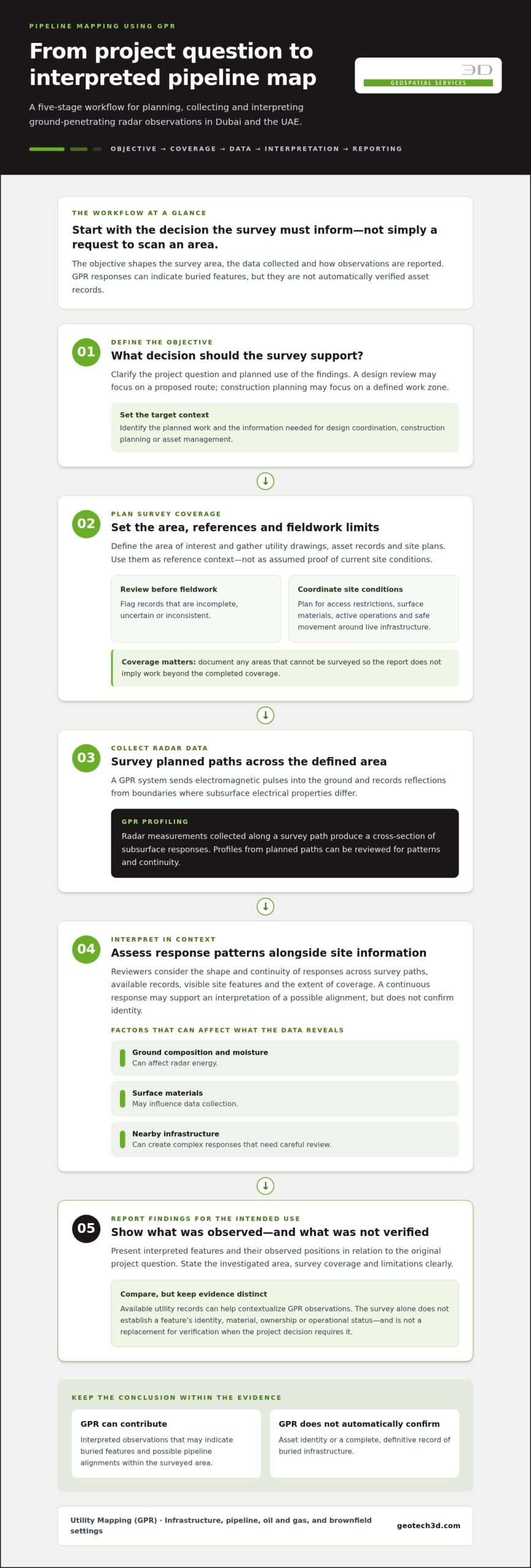
A useful survey starts with a project question, not simply a request to scan an area. Pipeline mapping using GPR typically follows five stages: define the objective, plan coverage, collect radar data, interpret responses in context and report findings in a format suited to the intended decision.
GPR profiling is the collection of radar measurements along a survey path to produce a cross-section of subsurface responses. Reviewing profiles from planned paths can help identify patterns that may indicate a buried feature and assess how they continue across the surveyed area.
Set the mapping objective and survey area
First, clarify the decision the survey should inform. A design team may need to review a proposed route, while a construction team may need information about a defined work zone. The objective helps determine which area to investigate and what level of detail the resulting information needs to support.
Gather existing utility drawings, asset records and site plans before fieldwork. These materials can help focus the area of interest and provide context for interpreting observations, but they should be treated as reference information rather than assumed to represent current site conditions. Flag records that are incomplete, uncertain or inconsistent, so the project team can consider those gaps when reviewing the findings.
Field planning also needs to account for practical conditions. Access restrictions, surface materials, active operations and safe movement around live infrastructure can affect where and how data is collected. Coordinate access and operating constraints in advance. If parts of the site cannot be surveyed, document the limits so the reporting does not imply coverage beyond the work completed.
Interpret GPR observations in their site context
Collected data needs technical interpretation. A response that appears continuous across survey paths may support an interpretation of a possible alignment, but it does not by itself confirm the feature’s identity. Reviewers consider the character and continuity of responses alongside available records, visible site features and the extent of survey coverage.
Ground composition and moisture can affect radar energy, and surface materials may influence data collection. Nearby infrastructure can also create complex responses that require careful review. Findings should therefore be presented as interpreted observations, with the survey scope and limitations clearly stated.
The report should connect observations to the original project question. It should make clear what area was investigated, which features were interpreted and how the results relate to the intended decision. This helps engineers, contractors, consultants and asset owners use the information appropriately without treating it as a definitive asset record.
For project-specific Utility Mapping (GPR) in Dubai, GEOTECH 3D’s Utility Mapping (GPR) supports planning around the site and the decisions the survey is intended to inform.
GPR Pipeline Mapping: Capabilities, Limitations, and Complementary Records
GPR observations can add field evidence, but a single survey method should not be assumed to identify every buried pipeline. The method’s usefulness depends on the site, survey scope and interpretation. Comparing observations with available records helps teams distinguish what the survey indicates from what remains uncertain.
| Information source | What it can contribute | What to keep in mind |
|---|---|---|
| GPR observations | Subsurface responses that may indicate a buried feature or possible alignment within the surveyed area. | A response does not automatically confirm a pipeline’s identity, material, function, ownership or full route. |
| Existing utility records | Recorded asset locations and details that provide context for reviewing field observations. | Records may have gaps or differ from conditions encountered on site; assess them alongside survey evidence. |
| Project verification needs | Additional checks or decisions required to resolve questions relevant to design or planned work. | The appropriate next step depends on the project decision and the level of certainty it requires. |
What can affect pipeline responses and interpretation?
Ground composition and moisture can influence radar response. Surface materials and physical access may affect where data can be collected, while nearby infrastructure can make responses more complex to interpret. Assess findings in relation to actual site conditions rather than treating them as universal evidence of a particular pipe type or route.
A mapped response is evidence to interpret alongside project records, not a standalone confirmation of an asset. Reporting should distinguish observed or interpreted features from confirmed information and stay within the agreed survey area and purpose. If a route continues beyond the surveyed coverage, the report should not imply that the unsurveyed portion has been established.
How GPR evidence fits with plans and other project information
Compare field observations with utility drawings, asset records and site context to identify where information aligns and where questions remain. For example, if an interpreted response does not correspond with a recorded route, document the difference for the project team to consider before relying on either source for a decision.
Useful documentation makes uncertainty actionable. Record conflicts, gaps in available records and locations where the survey scope does not resolve the question. This helps the project team decide whether further investigation or verification is relevant to the planned work. It also keeps the limits of the survey visible when its findings are used in design or construction planning.
Planning a GPR Pipeline Mapping Survey for a Dubai or UAE Project
A well-defined survey brief aligns fieldwork with the decisions a project team needs to make. For pipeline mapping using GPR, preparation is especially useful on active Dubai and UAE sites, where access, surface conditions and ongoing operations can shape the areas available for survey.
Information to prepare before fieldwork
Bring together information that defines the survey area and provides context for interpreting observations. Existing records are useful references, even when they may not show every asset or reflect current site conditions. Sharing them before fieldwork can help identify areas of interest, possible route conflicts and gaps that matter to the project.
- Project objective: State the decision the survey should inform, such as reviewing a proposed work area or supporting infrastructure planning.
- Site information: Provide available utility plans, pipeline records, site boundaries and relevant project drawings.
- Access and surface conditions: Identify accessible areas, obstructions, surface materials and locations where coverage may be constrained.
- Operating conditions: Describe active site activities and coordinate access and safety arrangements with the relevant project stakeholders.
- Required outputs: Clarify who will use the findings and how they should support the next design, construction or asset-management decision.
For example, a survey intended to inform work near a known pipeline corridor should have a defined investigation area related to the planned activity. The scope should describe that area and its purpose, rather than imply that GPR will identify every buried asset across the wider site.
Questions to resolve in the survey scope
Before work begins, agree on the area and assets of interest, the intended users of the results and how interpreted observations and unresolved questions will be presented. State access limitations and operating constraints so expectations match the work that can be carried out. The brief should also clarify how uncertainty will be communicated, helping teams distinguish mapped evidence from information that needs further project consideration.
These steps apply across Dubai and the UAE, whether the work concerns redevelopment, a utility corridor or an operating infrastructure site. The goal is a practical, coordinated survey scope suited to its intended use, without assuming a particular detection outcome.
GEOTECH 3D Utility Mapping (GPR) for Pipeline Projects
GEOTECH 3D provides Utility Mapping (GPR) through its GIS & Surveying Services. The service supports project teams seeking subsurface information for infrastructure planning, including work involving utilities, pipelines, oil and gas facilities, and brownfields in Dubai and the UAE. The survey scope should reflect the project objective and site context. Findings are mapped evidence to interpret, not a guarantee that every buried asset will be identified.
A project-focused approach to utility mapping
Useful mapping begins with a clear understanding of what the project needs to decide. The site area, available utility and pipeline records, access conditions and operating constraints all help shape a practical survey brief. Coordinating these details supports considered field planning, particularly where work is near live infrastructure or active operations.
Mapped information can contribute to design coordination, construction planning and asset management by giving teams additional context about possible subsurface features. Its value depends on how well the scope matches the decision at hand and how clearly observations and limitations are communicated. GEOTECH 3D’s Utility Mapping (GPR) is suited to pipeline and infrastructure needs, with interpreted responses kept distinct from definitive asset records.
For broader context on organizing underground utility information and project risk, use the survey planning principles in this guide: define the information need, make the survey area clear and document the limits of available evidence.
Next steps for pipeline mapping in Dubai
To begin a project discussion, outline the site location and boundaries, project stage and pipeline mapping objective. Share available drawings or asset records, identify access restrictions and site operations, and describe relevant safety coordination requirements. This context helps align survey planning with the intended use of the results.
Clear coordination supports practical collaboration between survey and project teams. GEOTECH 3D provides Utility Mapping (GPR) for pipeline and infrastructure needs, with attention to scope, site context and the decisions the mapped information is intended to inform.
Plan Your Next Pipeline Survey with Clear Project Goals
Effective pipeline mapping using GPR starts with a defined project question, a survey scope shaped around site access and operating conditions, and careful interpretation. GPR observations can inform design, construction planning and asset management, but they should be considered alongside existing records and the level of verification the project decision requires.
GEOTECH 3D provides Utility Mapping (GPR) through its GIS & Surveying Services for pipeline and brownfield work in the oil and gas sector, as well as infrastructure needs in Dubai and the UAE. A project-focused brief helps align fieldwork with site conditions and the information your team needs to make informed decisions. GEOTECH 3D emphasizes accuracy, safety compliance and the ability to meet tight schedules.
With a clear scope and coordinated planning, your team can address subsurface uncertainty with a practical basis for the next project decision.
Frequently Asked Questions
What is pipeline mapping using GPR?
Pipeline mapping using GPR is a subsurface investigation that records and interprets radar responses across a survey area. The observations can help project teams assess possible buried asset alignments and identify where further attention may be needed. They do not automatically confirm a pipeline’s material, ownership or operational status. Consider the findings alongside available project records and the survey’s defined scope.
Can GPR detect every underground pipeline?
No. GPR should not be treated as a guarantee that every buried pipeline will be detected or identified. Results depend on site and subsurface conditions, survey coverage and interpretation. Before using findings to guide design or construction, compare them with available utility records and the project context. Document unresolved questions clearly so the team understands what the survey indicates and where uncertainty remains.
How does GPR help map pipelines on a construction site?
GPR observations provide subsurface information that can help teams investigate possible pipeline alignments within a defined area. On a construction site, this may inform planning around a proposed work zone or support coordination between design and field teams. The value depends on a scope matched to the project decision, practical site access and appropriate safety coordination. Interpret observations alongside available records and site context.
What affects GPR pipeline mapping results?
Ground composition, moisture, surface materials, nearby infrastructure and survey conditions can influence collected responses and their interpretation. These factors vary between sites, so assess results in context rather than assuming they will be consistent everywhere. A clear survey scope and transparent reporting help project teams understand what the findings indicate, what remains uncertain and how the information may support decisions.
Is GPR pipeline mapping suitable for projects in Dubai and the UAE?
GPR can be considered for utility mapping on relevant construction, infrastructure, oil and gas, and brownfield projects in Dubai and the UAE. Suitability depends on the project objective, site conditions, access and survey scope. GEOTECH 3D provides Utility Mapping (GPR) through its GIS & Surveying Services. Interpret findings alongside available records, and do not assume one method will answer every subsurface question.
What information should I prepare for a GPR pipeline survey?
Prepare the survey area, project objective, available pipeline or utility records, site plans, and known access or operational constraints. Explain how the findings will support the next project decision and who will use the results. Sharing this context helps define practical survey coverage and reporting needs. It also supports coordination around site access and safety requirements before fieldwork.
Does GPR mapping confirm a pipeline’s material or ownership?
No. A GPR response alone does not confirm a pipeline’s material, ownership or operational status. It is an observation that must be interpreted in the project context and considered alongside supporting information, such as available asset records. Clear reporting distinguishes survey observations from recorded or otherwise verified details. This helps project teams use mapped evidence appropriately and identify where further verification may be relevant.

In Dubai and across the UAE, uncertainty about buried pipelines can complicate design coordination, site planning and excavation work. Pipeline mapping using GPR gives project teams another source of subsurface information: ground-penetrating radar records responses that may indicate buried features. Those responses require interpretation and should not be treated as definitive asset records or physical verification where a project requires it.
The usefulness of a GPR survey depends on the question it needs to answer. Ground conditions, site access, survey coverage and nearby infrastructure can all affect what the data reveals. Planning around live assets and ongoing site operations also helps make fieldwork practical and supports safe coordination.
This guide explains what GPR can contribute to pipeline mapping, how survey findings are interpreted and how to prepare a project scope. GEOTECH 3D provides Utility Mapping (GPR) for infrastructure needs in Dubai and the UAE, with survey planning shaped around project objectives, site conditions and intended use.
Key Takeaways
- Use pipeline mapping using GPR to inform project planning, while distinguishing interpreted survey observations from verified asset records.
- Plan the work in stages: define the project question, set survey coverage, collect and interpret data, then report findings against the intended use.
- Consider ground conditions and site context, and compare GPR observations with available utility records.
- Before fieldwork, define the survey area, access arrangements, operating constraints and required outputs.
- GEOTECH 3D provides Utility Mapping (GPR) for infrastructure, pipeline, oil and gas, and brownfield settings.
What Pipeline Mapping Using GPR Can Reveal on a Dubai Site
Before design or excavation decisions are made, project teams need a useful picture of what may lie beneath the work area. Pipeline mapping using GPR applies ground-penetrating radar to investigate the subsurface and identify response patterns that may indicate buried assets. It can help clarify possible pipeline alignments, but a radar response does not automatically establish a feature’s identity, material, ownership or operational status.
What GPR contributes to an underground pipeline survey
A GPR system sends electromagnetic pulses into the ground and records reflections from boundaries where subsurface electrical properties differ. As the survey moves across the site, the collected responses can be reviewed for patterns that may correspond to buried features. For a foundational overview of the method, see Ground-penetrating radar (GPR).
Interpreters assess the shape and continuity of responses alongside site context and the survey coverage. The resulting map can show interpreted features and their observed positions. Existing asset records provide a separate source of information and can help with comparison, but GPR alone should not be treated as confirmation of an asset or a replacement for verification when the project decision requires it.
When pipeline mapping matters to UAE project teams
Subsurface information can support decisions at different project stages. A design team may use it to review a proposed layout against possible buried infrastructure. Contractors and project managers can use mapped observations to plan work areas and coordinate site activities. Asset owners may use the information to improve their understanding of infrastructure in utility corridors, oil and gas facilities, or brownfields in Dubai and elsewhere in the UAE.
The value of a survey depends on the question it is meant to answer. A focused investigation of a planned work area has a different purpose from mapping a wider corridor for infrastructure planning. Ground conditions, access, nearby features and the extent of survey coverage can affect what the data reveals. Defining the intended decision helps set a useful scope and reduces the risk of mistaking observations for a complete asset record.
A clear project brief should identify the area of interest, the planned work and how the mapped information will be used. For example, a design review may require observations in a proposed route area, while construction planning may focus on a defined work zone. Matching coverage to the intended use gives the survey a practical role in design coordination, construction planning or asset management, while keeping conclusions within the evidence collected.
How GPR Pipeline Mapping Works, from Survey Planning to Interpretation
A useful survey starts with a project question, not simply a request to scan an area. Pipeline mapping using GPR typically follows five stages: define the objective, plan coverage, collect radar data, interpret responses in context and report findings in a format suited to the intended decision.
GPR profiling is the collection of radar measurements along a survey path to produce a cross-section of subsurface responses. Reviewing profiles from planned paths can help identify patterns that may indicate a buried feature and assess how they continue across the surveyed area.
Set the mapping objective and survey area
First, clarify the decision the survey should inform. A design team may need to review a proposed route, while a construction team may need information about a defined work zone. The objective helps determine which area to investigate and what level of detail the resulting information needs to support.
Gather existing utility drawings, asset records and site plans before fieldwork. These materials can help focus the area of interest and provide context for interpreting observations, but they should be treated as reference information rather than assumed to represent current site conditions. Flag records that are incomplete, uncertain or inconsistent, so the project team can consider those gaps when reviewing the findings.
Field planning also needs to account for practical conditions. Access restrictions, surface materials, active operations and safe movement around live infrastructure can affect where and how data is collected. Coordinate access and operating constraints in advance. If parts of the site cannot be surveyed, document the limits so the reporting does not imply coverage beyond the work completed.
Interpret GPR observations in their site context
Collected data needs technical interpretation. A response that appears continuous across survey paths may support an interpretation of a possible alignment, but it does not by itself confirm the feature’s identity. Reviewers consider the character and continuity of responses alongside available records, visible site features and the extent of survey coverage.
Ground composition and moisture can affect radar energy, and surface materials may influence data collection. Nearby infrastructure can also create complex responses that require careful review. Findings should therefore be presented as interpreted observations, with the survey scope and limitations clearly stated.
The report should connect observations to the original project question. It should make clear what area was investigated, which features were interpreted and how the results relate to the intended decision. This helps engineers, contractors, consultants and asset owners use the information appropriately without treating it as a definitive asset record.
For project-specific Utility Mapping (GPR) in Dubai, GEOTECH 3D’s Utility Mapping (GPR) supports planning around the site and the decisions the survey is intended to inform.
GPR Pipeline Mapping: Capabilities, Limitations, and Complementary Records
GPR observations can add field evidence, but a single survey method should not be assumed to identify every buried pipeline. The method’s usefulness depends on the site, survey scope and interpretation. Comparing observations with available records helps teams distinguish what the survey indicates from what remains uncertain.
| Information source | What it can contribute | What to keep in mind |
|---|---|---|
| GPR observations | Subsurface responses that may indicate a buried feature or possible alignment within the surveyed area. | A response does not automatically confirm a pipeline’s identity, material, function, ownership or full route. |
| Existing utility records | Recorded asset locations and details that provide context for reviewing field observations. | Records may have gaps or differ from conditions encountered on site; assess them alongside survey evidence. |
| Project verification needs | Additional checks or decisions required to resolve questions relevant to design or planned work. | The appropriate next step depends on the project decision and the level of certainty it requires. |
What can affect pipeline responses and interpretation?
Ground composition and moisture can influence radar response. Surface materials and physical access may affect where data can be collected, while nearby infrastructure can make responses more complex to interpret. Assess findings in relation to actual site conditions rather than treating them as universal evidence of a particular pipe type or route.
A mapped response is evidence to interpret alongside project records, not a standalone confirmation of an asset. Reporting should distinguish observed or interpreted features from confirmed information and stay within the agreed survey area and purpose. If a route continues beyond the surveyed coverage, the report should not imply that the unsurveyed portion has been established.
How GPR evidence fits with plans and other project information
Compare field observations with utility drawings, asset records and site context to identify where information aligns and where questions remain. For example, if an interpreted response does not correspond with a recorded route, document the difference for the project team to consider before relying on either source for a decision.
Useful documentation makes uncertainty actionable. Record conflicts, gaps in available records and locations where the survey scope does not resolve the question. This helps the project team decide whether further investigation or verification is relevant to the planned work. It also keeps the limits of the survey visible when its findings are used in design or construction planning.
Planning a GPR Pipeline Mapping Survey for a Dubai or UAE Project
A well-defined survey brief aligns fieldwork with the decisions a project team needs to make. For pipeline mapping using GPR, preparation is especially useful on active Dubai and UAE sites, where access, surface conditions and ongoing operations can shape the areas available for survey.
Information to prepare before fieldwork
Bring together information that defines the survey area and provides context for interpreting observations. Existing records are useful references, even when they may not show every asset or reflect current site conditions. Sharing them before fieldwork can help identify areas of interest, possible route conflicts and gaps that matter to the project.
- Project objective: State the decision the survey should inform, such as reviewing a proposed work area or supporting infrastructure planning.
- Site information: Provide available utility plans, pipeline records, site boundaries and relevant project drawings.
- Access and surface conditions: Identify accessible areas, obstructions, surface materials and locations where coverage may be constrained.
- Operating conditions: Describe active site activities and coordinate access and safety arrangements with the relevant project stakeholders.
- Required outputs: Clarify who will use the findings and how they should support the next design, construction or asset-management decision.
For example, a survey intended to inform work near a known pipeline corridor should have a defined investigation area related to the planned activity. The scope should describe that area and its purpose, rather than imply that GPR will identify every buried asset across the wider site.
Questions to resolve in the survey scope
Before work begins, agree on the area and assets of interest, the intended users of the results and how interpreted observations and unresolved questions will be presented. State access limitations and operating constraints so expectations match the work that can be carried out. The brief should also clarify how uncertainty will be communicated, helping teams distinguish mapped evidence from information that needs further project consideration.
These steps apply across Dubai and the UAE, whether the work concerns redevelopment, a utility corridor or an operating infrastructure site. The goal is a practical, coordinated survey scope suited to its intended use, without assuming a particular detection outcome.
GEOTECH 3D Utility Mapping (GPR) for Pipeline Projects
GEOTECH 3D provides Utility Mapping (GPR) through its GIS & Surveying Services. The service supports project teams seeking subsurface information for infrastructure planning, including work involving utilities, pipelines, oil and gas facilities, and brownfields in Dubai and the UAE. The survey scope should reflect the project objective and site context. Findings are mapped evidence to interpret, not a guarantee that every buried asset will be identified.
A project-focused approach to utility mapping
Useful mapping begins with a clear understanding of what the project needs to decide. The site area, available utility and pipeline records, access conditions and operating constraints all help shape a practical survey brief. Coordinating these details supports considered field planning, particularly where work is near live infrastructure or active operations.
Mapped information can contribute to design coordination, construction planning and asset management by giving teams additional context about possible subsurface features. Its value depends on how well the scope matches the decision at hand and how clearly observations and limitations are communicated. GEOTECH 3D’s Utility Mapping (GPR) is suited to pipeline and infrastructure needs, with interpreted responses kept distinct from definitive asset records.
For broader context on organizing underground utility information and project risk, use the survey planning principles in this guide: define the information need, make the survey area clear and document the limits of available evidence.
Next steps for pipeline mapping in Dubai
To begin a project discussion, outline the site location and boundaries, project stage and pipeline mapping objective. Share available drawings or asset records, identify access restrictions and site operations, and describe relevant safety coordination requirements. This context helps align survey planning with the intended use of the results.
Clear coordination supports practical collaboration between survey and project teams. GEOTECH 3D provides Utility Mapping (GPR) for pipeline and infrastructure needs, with attention to scope, site context and the decisions the mapped information is intended to inform.
Plan Your Next Pipeline Survey with Clear Project Goals
Effective pipeline mapping using GPR starts with a defined project question, a survey scope shaped around site access and operating conditions, and careful interpretation. GPR observations can inform design, construction planning and asset management, but they should be considered alongside existing records and the level of verification the project decision requires.
GEOTECH 3D provides Utility Mapping (GPR) through its GIS & Surveying Services for pipeline and brownfield work in the oil and gas sector, as well as infrastructure needs in Dubai and the UAE. A project-focused brief helps align fieldwork with site conditions and the information your team needs to make informed decisions. GEOTECH 3D emphasizes accuracy, safety compliance and the ability to meet tight schedules.
With a clear scope and coordinated planning, your team can address subsurface uncertainty with a practical basis for the next project decision.
Frequently Asked Questions
What is pipeline mapping using GPR?
Pipeline mapping using GPR is a subsurface investigation that records and interprets radar responses across a survey area. The observations can help project teams assess possible buried asset alignments and identify where further attention may be needed. They do not automatically confirm a pipeline’s material, ownership or operational status. Consider the findings alongside available project records and the survey’s defined scope.
Can GPR detect every underground pipeline?
No. GPR should not be treated as a guarantee that every buried pipeline will be detected or identified. Results depend on site and subsurface conditions, survey coverage and interpretation. Before using findings to guide design or construction, compare them with available utility records and the project context. Document unresolved questions clearly so the team understands what the survey indicates and where uncertainty remains.
How does GPR help map pipelines on a construction site?
GPR observations provide subsurface information that can help teams investigate possible pipeline alignments within a defined area. On a construction site, this may inform planning around a proposed work zone or support coordination between design and field teams. The value depends on a scope matched to the project decision, practical site access and appropriate safety coordination. Interpret observations alongside available records and site context.
What affects GPR pipeline mapping results?
Ground composition, moisture, surface materials, nearby infrastructure and survey conditions can influence collected responses and their interpretation. These factors vary between sites, so assess results in context rather than assuming they will be consistent everywhere. A clear survey scope and transparent reporting help project teams understand what the findings indicate, what remains uncertain and how the information may support decisions.
Is GPR pipeline mapping suitable for projects in Dubai and the UAE?
GPR can be considered for utility mapping on relevant construction, infrastructure, oil and gas, and brownfield projects in Dubai and the UAE. Suitability depends on the project objective, site conditions, access and survey scope. GEOTECH 3D provides Utility Mapping (GPR) through its GIS & Surveying Services. Interpret findings alongside available records, and do not assume one method will answer every subsurface question.
What information should I prepare for a GPR pipeline survey?
Prepare the survey area, project objective, available pipeline or utility records, site plans, and known access or operational constraints. Explain how the findings will support the next project decision and who will use the results. Sharing this context helps define practical survey coverage and reporting needs. It also supports coordination around site access and safety requirements before fieldwork.
Does GPR mapping confirm a pipeline’s material or ownership?
No. A GPR response alone does not confirm a pipeline’s material, ownership or operational status. It is an observation that must be interpreted in the project context and considered alongside supporting information, such as available asset records. Clear reporting distinguishes survey observations from recorded or otherwise verified details. This helps project teams use mapped evidence appropriately and identify where further verification may be relevant.
Search Now
Error: Contact form not found.