

Our Services
Surveying Company Near Me in Dubai: How to Choose the Right Team
The closest surveying company isn’t automatically the right fit for your project. Choosing a surveying company near me Dubai means looking beyond location to the survey scope, required deliverables, technical capabilities and experience working in the local project environment. For example, a brief that needs terrain and visible site features mapped is different from one focused on parcel information or buried utilities. A mismatch between the brief and the data collected can create avoidable coordination challenges later.
Before commissioning a survey, get clear on which service suits the site, what information will be delivered and how your team will use it for design or construction. This guide explains how to match the survey type to the project, prepare a focused brief and compare a company’s stated capabilities with your requirements.
At GEOTECH 3D, GIS and surveying services in Dubai include Topographic Mapping, Cadastral Mapping, Utility Mapping (GPR) and Land Survey. The right scope depends on what your team needs to establish, document or coordinate. Use the project purpose, site context and required outputs to guide the discussion before work begins.
Key Takeaways
- Choose a surveying company near me Dubai by how well its capabilities and outputs match your project, not by proximity alone.
- Define the purpose of your Topographic Mapping survey to establish appropriate site coverage, level of detail and output format.
- Compare companies using clear evidence of scope fit, survey methods, deliverables and relevant Dubai project coverage.
- Prepare the site location, boundary, project purpose, stage and known constraints to make your project discussion more focused.
- Explore how GEOTECH 3D’s Topographic Mapping, Cadastral Mapping, Utility Mapping (GPR) and Land Survey services relate to your requirements.
Choosing a Surveying Company Near You in Dubai: Start With Project Fit
Finding a local team is only the first step. If you’re assessing a surveying company near me Dubai, ask whether its stated services and deliverables align with your site, project purpose and design or construction stage. Proximity can make site coordination more convenient, but it doesn’t define the survey scope or confirm that the outputs will support your next decisions.
Start by identifying what the survey needs to establish. A site being assessed for early design coordination may need different information from one where the project team needs land parcel details or a record of existing site features. A Topographic Survey generally records terrain and site features. The area covered and level of detail should be considered in relation to how the resulting information will be used.
Before discussing the scope, assemble a concise checklist:
- Location: Provide the Dubai site location and any available address or location reference.
- Survey purpose: Explain the decision, design task or site understanding the survey must support.
- Site context: Share available boundary information and describe relevant site conditions or constraints.
- Required outputs: Identify the formats or information your project team needs, if already specified.
- Coordination needs: Note the project stage, key stakeholders and how survey information will be used alongside other project inputs.
What to compare beyond a company’s Dubai location
Match the company’s stated services to the site and objective, then look for a clear explanation of the proposed data capture, mapping scope and intended outputs. A broad service list alone doesn’t show whether the work fits your brief. Compare the information provided about the specific service with your project needs, rather than treating general claims as evidence of a particular capability.
Keep the comparison practical: Is the area to be surveyed clear? Are the relevant features and intended deliverables described? Can you see how the outputs relate to your project requirements? GEOTECH 3D provides GIS & Surveying Services in Dubai, including Topographic Mapping, Cadastral Mapping, Utility Mapping (GPR) and Land Survey. Start with the project purpose and site context to identify which service is relevant.
When the Dubai Land Department directory is relevant
The Dubai Land Department directory can be used as a reference for identifying surveying companies listed there and accessing their contact details. Use it when your project or internal process specifically calls for that directory. A directory listing serves a different purpose from a technical assessment of survey scope, methods or deliverables.
Keep those questions separate. Directory information does not, by itself, explain whether a company’s Topographic Mapping scope matches your site or intended use. Assess technical fit using the company’s stated services and project-specific information. A clear brief makes the discussion more precise and supports alignment on the work required.
Topographic Survey Scope and Deliverables: Define What Your Dubai Project Needs
Topographic Mapping provides spatial information about a site’s terrain and physical features, helping project teams understand existing conditions. The required scope depends on what the information needs to support. A planning review, design coordination exercise and construction task may call for different site coverage, levels of detail and output formats. Defining the intended use first gives the survey discussion a clear basis.
Be specific about what the team needs to understand or document. A brief focused on the overall site may differ from one that needs particular areas or features captured in greater detail. These are scope considerations, not fixed specifications. Let the project requirements determine what is captured and how the information is presented.
How to describe your site and survey purpose
Set out the site location, available boundary information, access conditions and current project stage. State whether the survey will support design, planning, construction or asset documentation, and identify known site constraints or coordination needs. This context helps frame a project-specific discussion without assuming technical standards that haven’t been provided by your design team or project documentation.
Before requesting a scope, gather relevant project information:
- Location and boundary: Share the site reference and boundary information available to your team.
- Purpose and stage: Explain how the survey will be used and where the project stands.
- Constraints: Note access conditions, areas of particular interest and coordination requirements.
- Project specifications: Identify any required coordinate system, boundary basis, accuracy criteria or file formats stated in the project documents.
Don’t assume coordinate references, accuracy requirements or delivery formats are universal. Use the project specifications or direction from the relevant project team to define them. If requirements are still being developed, mark them as open questions in the brief so they can be addressed directly in the scope discussion.
Which mapping and surveying services may be relevant
Choose the service by purpose. Topographic Mapping is relevant when the project needs mapped information about site features and terrain. Cadastral Mapping relates to land parcels and boundaries, while Land Survey is a separate service that may suit other land-related requirements. The service name alone doesn’t define the full scope. The site, intended use and project specifications do.
If underground assets are also part of the project, include that need in the brief rather than assuming surface mapping covers it. GEOTECH 3D provides Utility Mapping (GPR), and this Dubai utility mapping guide offers further context for considering subsurface information alongside site mapping.
A clear scope discussion starts with the information your project needs, not an assumed method or deliverable. To discuss a Dubai Topographic Mapping requirement, share the project purpose and available site specifications with GEOTECH 3D’s GIS and surveying team.
How to Compare Dubai Surveying Companies by Capability and Project Fit
A useful comparison focuses on the service your project needs, not the length of a company’s service list. If you’re assessing a surveying company near me Dubai, use the same brief and criteria for each company. This makes it easier to separate relevant evidence from broad claims and identify where the project discussion needs more detail.
A practical company comparison framework
Record what each company clearly states about the requested survey. A service page can help establish whether the service is among its stated capabilities, but the detail behind that listing matters. Look for information about scope, data capture, outputs and handover expectations that relates to your project brief.
- Scope match: Does the company explicitly name the survey service you need, and does its description relate to your project purpose?
- Methods and data: Does its information explain how the survey scope and data capture relate to the requested work? Don’t treat a technology name alone as proof of fit.
- Stated outputs: Are the intended deliverables described clearly enough to compare with your project requirements?
- Dubai coverage: Is there evidence of a Dubai presence or relevant local project coverage? Treat location and accessible contact details as coordination factors, not technical credentials.
Separate documented information from assumptions. A page that names Topographic Mapping documents that service as a stated capability. A general claim of high accuracy or speed is harder to compare unless it includes specific, relevant information that can be assessed against the same project requirements. Don’t rank companies on accuracy, turnaround, equipment or credentials from slogans alone. If the information isn’t clear or comparable, record it as an open point instead of filling the gap with an assumption.
GEOTECH 3D provides GIS & Surveying Services in Dubai, including Topographic Mapping, Cadastral Mapping, Utility Mapping (GPR) and Land Survey. Comparing the requested service against the brief keeps the evaluation specific and avoids giving undue weight to services that may not be relevant to your site.
When topographic mapping is only one part of the scope
A project may need more than mapped surface features. Consider Cadastral Mapping or Land Survey if the stated project purpose involves parcel or land information. Keep those needs distinct from Topographic Mapping so each requested outcome is visible in the comparison. The services may relate to the same site, but they address different project questions.
Assess underground assets separately. If subsurface information is part of the brief, include Utility Mapping (GPR) as its own comparison item rather than assuming it is covered by topographic work. GEOTECH 3D’s subsurface utility engineering guide explains this distinct area of scope.
Once you’ve compared stated capabilities and outputs against the same brief, focus the next discussion on specific requirements and unresolved details. That gives your team a more grounded basis for selecting a surveying partner in Dubai.
Prepare a Clear Survey Brief Before Contacting a Dubai Surveying Company
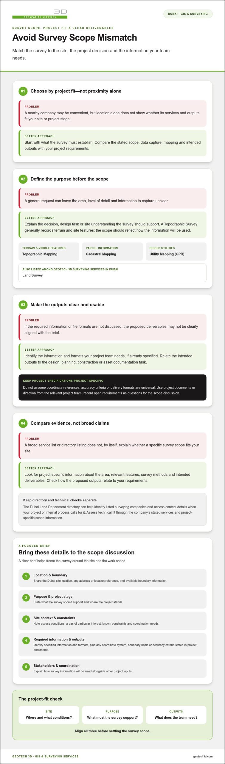
A concise, well-organised brief helps turn an initial enquiry into a focused project discussion. Before contacting a surveying company near me Dubai, gather the information your team already has and distinguish confirmed requirements from open questions. You don’t need to resolve every technical detail in advance. The aim is to explain the site, the intended use of the survey and the information your project team needs.
Five details to include in your initial project brief
Use this sequence to structure the brief. If a detail is unavailable, say so rather than estimating or assuming a requirement.
- Site location and boundary: Provide the Dubai site location and available boundary drawings, references or plans. Note whether the boundary information is preliminary or forms part of an agreed project specification.
- Site context and access: Describe relevant conditions known to your team, including access arrangements and areas that may affect survey coordination. Share available site plans or reference material that can help clarify the location.
- Project purpose: Explain whether the survey information will support design, planning, construction or asset documentation. Where possible, describe the decision or work it needs to inform.
- Project stage and coordination: State the current stage and identify relevant project stakeholders or coordination requirements. Note known access, safety or scheduling considerations without assuming arrangements that haven’t been agreed.
- Deliverables and specifications: List the expected outputs and file formats if your project team has defined them. Include any coordinate information, accuracy requirements or other technical specifications provided in project documents.
These details help distinguish essential requirements from preferences. For example, a requested file format may come from a design team’s workflow, while project specifications may define coordinate information or accuracy criteria. Include those instructions as provided. Don’t substitute a guessed standard or invent a technical threshold when the brief doesn’t specify one.
Make a project enquiry actionable
Attach relevant drawings, boundary references or other project materials where appropriate, and label them clearly so their purpose is easy to understand. If documents show different site extents or revisions, identify which information your team currently intends to use. This keeps the discussion grounded in available materials rather than assumptions about the site.
For access, safety, scheduling and coordination, share known constraints and the appropriate project contact or team context. Keep unresolved items visible. A focused enquiry can state what’s confirmed, what information is attached and which technical questions still need project-specific discussion.
Once your brief is organised, you can review GEOTECH 3D’s surveying services and share the project information relevant to your Dubai site.
GEOTECH 3D Surveying Services in Dubai: Discuss Your Topographic Mapping Scope
Once you’ve defined what the project needs from a survey, discuss the scope with a team whose stated services align with that purpose. GEOTECH 3D provides GIS & Surveying Services in Dubai. For projects requiring mapped information about site features and terrain, Topographic Mapping is the primary service relevant to this guide.
A project brief gives that discussion practical direction. Site location, available boundary information, project stage and intended use help frame which areas and details matter to your team. Include required outputs and any project specifications already provided, such as coordinate information or file formats. This helps keep the conversation focused on your requirements rather than assumptions about the survey.
Relevant GEOTECH 3D services for Dubai projects
Topographic Mapping supports projects that need mapped site and terrain information. Its relevance depends on the intended use and the scope set out in your project brief. If your requirements also relate to parcels or land information, Cadastral Mapping or Land Survey may be relevant as distinct services, guided by the project purpose.
Underground assets call for separate consideration. If subsurface asset mapping is part of your project, include Utility Mapping (GPR) as a distinct scope rather than assuming it forms part of Topographic Mapping. Identifying this need at the outset helps clarify how the requested information relates to the broader site requirements.
For teams assessing a surveying company near me Dubai, service names are a starting point, not a substitute for a project-specific scope. Explain what the team needs to understand, document or coordinate, and identify technical requirements already defined in project materials. Where a requirement remains open, state that clearly so it can be addressed in the discussion instead of relying on a guessed standard.
Start a project discussion with the Dubai office
GEOTECH 3D’s Dubai office is at Ilyaa Tower 2 – Office 101, Damascus St., Al Qusais Industrial 3. The telephone number is +971 4 295 1589. When making an enquiry, share the project location, purpose, stage and available reference documents, along with the outputs or specifications your team has identified. This provides a clear foundation for discussing the survey scope.
Whether your brief is for Topographic Mapping alone or includes another relevant surveying requirement, describe the intended use and site context. The discussion can then focus on aligning the scope and expected outputs with the information your project team needs.
Use the GEOTECH 3D website to share your requirements and begin a focused discussion about surveying in Dubai.
Set Your Project Up for a Confident Next Step
Your survey brief can become a practical reference point as the project develops. Keep it aligned with the decisions the information needs to support, and update it when the site boundary, project stage or design requirements change. This gives your team a consistent basis for discussing scope and reviewing whether proposed outputs remain useful as coordination progresses.
Choosing a surveying company near me Dubai is most productive when the conversation moves beyond location to the information your project needs and how it will be used. Bring forward the requirements your team has established, and keep unresolved technical details visible rather than making assumptions. A focused discussion can help clarify the next steps for commissioning survey work that fits the project brief.
Frequently Asked Questions
How do I choose a surveying company near me in Dubai?
Choose a surveying company by matching its stated scope to your project purpose, site context, required outputs and specifications. For a surveying company near me Dubai, proximity may simplify site coordination, but it doesn’t establish technical suitability. Review the Dubai Land Department directory if your project requirements call for that reference. Treat directory information as a listing resource, not an assessment of a company’s technical approach or fit for your specific survey.
What is the difference between a topographic survey and a land survey?
The terms can relate to different, though sometimes connected, project needs. The appropriate scope depends on what information your team requires and what the project specifications define. GEOTECH 3D lists Topographic Mapping and Land Survey as separate GIS & Surveying Services. Rather than assuming the terms describe identical work or fixed deliverables, explain the decision the survey must support and use the project brief to clarify the required scope.
Can a drone be used for a topographic survey in Dubai?
Aerial methods may suit some topographic survey requirements, depending on the site and project brief. GEOTECH 3D lists Aerial Survey and Digital Photogrammetry Services among its offerings. Consider the capture approach against the site context, intended use and project specifications. Don’t assume a drone is suitable, or will provide a particular accuracy or deliverable, without project-specific information to support that decision.
What information should I provide when requesting a topographic survey?
Share the site location, available boundary information, project purpose and current stage, along with known access or safety constraints. Include the outputs your team expects and any client-provided technical specifications. If you have drawings, identify their revision or status so the discussion uses the intended reference material. Leave unspecified coordinate systems, accuracy criteria and file formats open rather than choosing them without direction from the project requirements.
Does a topographic survey locate underground utilities?
Not necessarily. Topographic Mapping and underground utility mapping are distinct scopes, so don’t assume surface survey information identifies buried assets. GEOTECH 3D separately provides Utility Mapping (GPR). If subsurface assets matter to design or construction coordination, state that need in the project brief. The subsurface utility engineering guide provides further context on this separate scope.
How long does a topographic survey in Dubai take?
There isn’t one duration that applies to every topographic survey. The schedule depends on the agreed scope, site conditions, access and required outputs. A complex site or specific coordination requirements may call for a different plan from a more straightforward brief. Share the available site information and requirements so the schedule can be discussed in the context of the project, rather than relying on a generic estimate.
Where is GEOTECH 3D’s Dubai office?
GEOTECH 3D’s Dubai office is at Ilyaa Tower 2 – Office 101, Damascus St., Al Qusais Industrial 3, Dubai, UAE. The telephone number is +971 4 295 1589. When making a project enquiry, share the site location and survey purpose to help frame a focused discussion about the requirements.
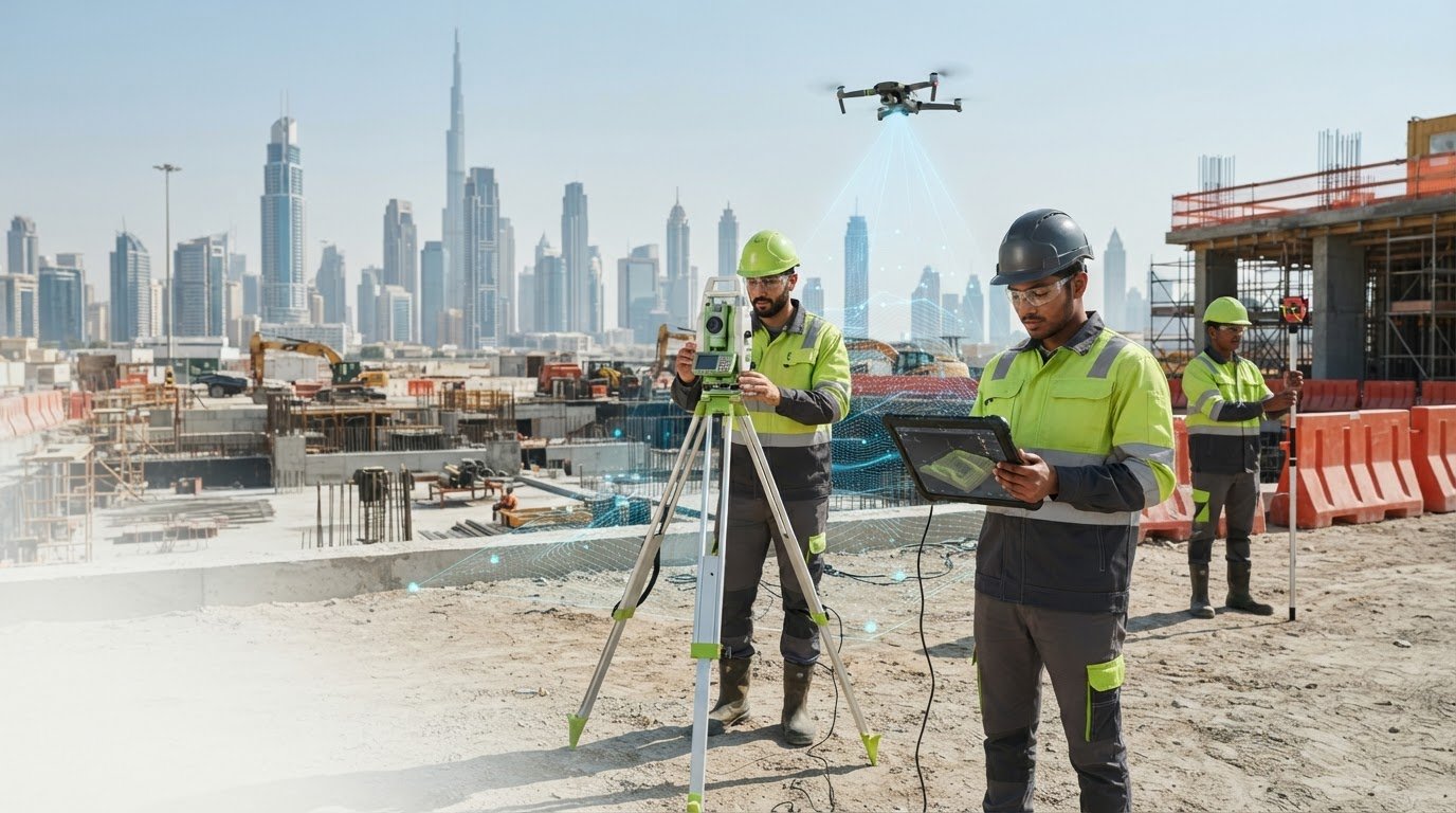
The closest surveying company isn’t automatically the right fit for your project. Choosing a surveying company near me Dubai means looking beyond location to the survey scope, required deliverables, technical capabilities and experience working in the local project environment. For example, a brief that needs terrain and visible site features mapped is different from one focused on parcel information or buried utilities. A mismatch between the brief and the data collected can create avoidable coordination challenges later.
Before commissioning a survey, get clear on which service suits the site, what information will be delivered and how your team will use it for design or construction. This guide explains how to match the survey type to the project, prepare a focused brief and compare a company’s stated capabilities with your requirements.
At GEOTECH 3D, GIS and surveying services in Dubai include Topographic Mapping, Cadastral Mapping, Utility Mapping (GPR) and Land Survey. The right scope depends on what your team needs to establish, document or coordinate. Use the project purpose, site context and required outputs to guide the discussion before work begins.
Key Takeaways
- Choose a surveying company near me Dubai by how well its capabilities and outputs match your project, not by proximity alone.
- Define the purpose of your Topographic Mapping survey to establish appropriate site coverage, level of detail and output format.
- Compare companies using clear evidence of scope fit, survey methods, deliverables and relevant Dubai project coverage.
- Prepare the site location, boundary, project purpose, stage and known constraints to make your project discussion more focused.
- Explore how GEOTECH 3D’s Topographic Mapping, Cadastral Mapping, Utility Mapping (GPR) and Land Survey services relate to your requirements.
Choosing a Surveying Company Near You in Dubai: Start With Project Fit
Finding a local team is only the first step. If you’re assessing a surveying company near me Dubai, ask whether its stated services and deliverables align with your site, project purpose and design or construction stage. Proximity can make site coordination more convenient, but it doesn’t define the survey scope or confirm that the outputs will support your next decisions.
Start by identifying what the survey needs to establish. A site being assessed for early design coordination may need different information from one where the project team needs land parcel details or a record of existing site features. A Topographic Survey generally records terrain and site features. The area covered and level of detail should be considered in relation to how the resulting information will be used.
Before discussing the scope, assemble a concise checklist:
- Location: Provide the Dubai site location and any available address or location reference.
- Survey purpose: Explain the decision, design task or site understanding the survey must support.
- Site context: Share available boundary information and describe relevant site conditions or constraints.
- Required outputs: Identify the formats or information your project team needs, if already specified.
- Coordination needs: Note the project stage, key stakeholders and how survey information will be used alongside other project inputs.
What to compare beyond a company’s Dubai location
Match the company’s stated services to the site and objective, then look for a clear explanation of the proposed data capture, mapping scope and intended outputs. A broad service list alone doesn’t show whether the work fits your brief. Compare the information provided about the specific service with your project needs, rather than treating general claims as evidence of a particular capability.
Keep the comparison practical: Is the area to be surveyed clear? Are the relevant features and intended deliverables described? Can you see how the outputs relate to your project requirements? GEOTECH 3D provides GIS & Surveying Services in Dubai, including Topographic Mapping, Cadastral Mapping, Utility Mapping (GPR) and Land Survey. Start with the project purpose and site context to identify which service is relevant.
When the Dubai Land Department directory is relevant
The Dubai Land Department directory can be used as a reference for identifying surveying companies listed there and accessing their contact details. Use it when your project or internal process specifically calls for that directory. A directory listing serves a different purpose from a technical assessment of survey scope, methods or deliverables.
Keep those questions separate. Directory information does not, by itself, explain whether a company’s Topographic Mapping scope matches your site or intended use. Assess technical fit using the company’s stated services and project-specific information. A clear brief makes the discussion more precise and supports alignment on the work required.
Topographic Survey Scope and Deliverables: Define What Your Dubai Project Needs
Topographic Mapping provides spatial information about a site’s terrain and physical features, helping project teams understand existing conditions. The required scope depends on what the information needs to support. A planning review, design coordination exercise and construction task may call for different site coverage, levels of detail and output formats. Defining the intended use first gives the survey discussion a clear basis.
Be specific about what the team needs to understand or document. A brief focused on the overall site may differ from one that needs particular areas or features captured in greater detail. These are scope considerations, not fixed specifications. Let the project requirements determine what is captured and how the information is presented.
How to describe your site and survey purpose
Set out the site location, available boundary information, access conditions and current project stage. State whether the survey will support design, planning, construction or asset documentation, and identify known site constraints or coordination needs. This context helps frame a project-specific discussion without assuming technical standards that haven’t been provided by your design team or project documentation.
Before requesting a scope, gather relevant project information:
- Location and boundary: Share the site reference and boundary information available to your team.
- Purpose and stage: Explain how the survey will be used and where the project stands.
- Constraints: Note access conditions, areas of particular interest and coordination requirements.
- Project specifications: Identify any required coordinate system, boundary basis, accuracy criteria or file formats stated in the project documents.
Don’t assume coordinate references, accuracy requirements or delivery formats are universal. Use the project specifications or direction from the relevant project team to define them. If requirements are still being developed, mark them as open questions in the brief so they can be addressed directly in the scope discussion.
Which mapping and surveying services may be relevant
Choose the service by purpose. Topographic Mapping is relevant when the project needs mapped information about site features and terrain. Cadastral Mapping relates to land parcels and boundaries, while Land Survey is a separate service that may suit other land-related requirements. The service name alone doesn’t define the full scope. The site, intended use and project specifications do.
If underground assets are also part of the project, include that need in the brief rather than assuming surface mapping covers it. GEOTECH 3D provides Utility Mapping (GPR), and this Dubai utility mapping guide offers further context for considering subsurface information alongside site mapping.
A clear scope discussion starts with the information your project needs, not an assumed method or deliverable. To discuss a Dubai Topographic Mapping requirement, share the project purpose and available site specifications with GEOTECH 3D’s GIS and surveying team.
How to Compare Dubai Surveying Companies by Capability and Project Fit
A useful comparison focuses on the service your project needs, not the length of a company’s service list. If you’re assessing a surveying company near me Dubai, use the same brief and criteria for each company. This makes it easier to separate relevant evidence from broad claims and identify where the project discussion needs more detail.
A practical company comparison framework
Record what each company clearly states about the requested survey. A service page can help establish whether the service is among its stated capabilities, but the detail behind that listing matters. Look for information about scope, data capture, outputs and handover expectations that relates to your project brief.
- Scope match: Does the company explicitly name the survey service you need, and does its description relate to your project purpose?
- Methods and data: Does its information explain how the survey scope and data capture relate to the requested work? Don’t treat a technology name alone as proof of fit.
- Stated outputs: Are the intended deliverables described clearly enough to compare with your project requirements?
- Dubai coverage: Is there evidence of a Dubai presence or relevant local project coverage? Treat location and accessible contact details as coordination factors, not technical credentials.
Separate documented information from assumptions. A page that names Topographic Mapping documents that service as a stated capability. A general claim of high accuracy or speed is harder to compare unless it includes specific, relevant information that can be assessed against the same project requirements. Don’t rank companies on accuracy, turnaround, equipment or credentials from slogans alone. If the information isn’t clear or comparable, record it as an open point instead of filling the gap with an assumption.
GEOTECH 3D provides GIS & Surveying Services in Dubai, including Topographic Mapping, Cadastral Mapping, Utility Mapping (GPR) and Land Survey. Comparing the requested service against the brief keeps the evaluation specific and avoids giving undue weight to services that may not be relevant to your site.
When topographic mapping is only one part of the scope
A project may need more than mapped surface features. Consider Cadastral Mapping or Land Survey if the stated project purpose involves parcel or land information. Keep those needs distinct from Topographic Mapping so each requested outcome is visible in the comparison. The services may relate to the same site, but they address different project questions.
Assess underground assets separately. If subsurface information is part of the brief, include Utility Mapping (GPR) as its own comparison item rather than assuming it is covered by topographic work. GEOTECH 3D’s subsurface utility engineering guide explains this distinct area of scope.
Once you’ve compared stated capabilities and outputs against the same brief, focus the next discussion on specific requirements and unresolved details. That gives your team a more grounded basis for selecting a surveying partner in Dubai.
Prepare a Clear Survey Brief Before Contacting a Dubai Surveying Company
A concise, well-organised brief helps turn an initial enquiry into a focused project discussion. Before contacting a surveying company near me Dubai, gather the information your team already has and distinguish confirmed requirements from open questions. You don’t need to resolve every technical detail in advance. The aim is to explain the site, the intended use of the survey and the information your project team needs.
Five details to include in your initial project brief
Use this sequence to structure the brief. If a detail is unavailable, say so rather than estimating or assuming a requirement.
- Site location and boundary: Provide the Dubai site location and available boundary drawings, references or plans. Note whether the boundary information is preliminary or forms part of an agreed project specification.
- Site context and access: Describe relevant conditions known to your team, including access arrangements and areas that may affect survey coordination. Share available site plans or reference material that can help clarify the location.
- Project purpose: Explain whether the survey information will support design, planning, construction or asset documentation. Where possible, describe the decision or work it needs to inform.
- Project stage and coordination: State the current stage and identify relevant project stakeholders or coordination requirements. Note known access, safety or scheduling considerations without assuming arrangements that haven’t been agreed.
- Deliverables and specifications: List the expected outputs and file formats if your project team has defined them. Include any coordinate information, accuracy requirements or other technical specifications provided in project documents.
These details help distinguish essential requirements from preferences. For example, a requested file format may come from a design team’s workflow, while project specifications may define coordinate information or accuracy criteria. Include those instructions as provided. Don’t substitute a guessed standard or invent a technical threshold when the brief doesn’t specify one.
Make a project enquiry actionable
Attach relevant drawings, boundary references or other project materials where appropriate, and label them clearly so their purpose is easy to understand. If documents show different site extents or revisions, identify which information your team currently intends to use. This keeps the discussion grounded in available materials rather than assumptions about the site.
For access, safety, scheduling and coordination, share known constraints and the appropriate project contact or team context. Keep unresolved items visible. A focused enquiry can state what’s confirmed, what information is attached and which technical questions still need project-specific discussion.
Once your brief is organised, you can review GEOTECH 3D’s surveying services and share the project information relevant to your Dubai site.
GEOTECH 3D Surveying Services in Dubai: Discuss Your Topographic Mapping Scope
Once you’ve defined what the project needs from a survey, discuss the scope with a team whose stated services align with that purpose. GEOTECH 3D provides GIS & Surveying Services in Dubai. For projects requiring mapped information about site features and terrain, Topographic Mapping is the primary service relevant to this guide.
A project brief gives that discussion practical direction. Site location, available boundary information, project stage and intended use help frame which areas and details matter to your team. Include required outputs and any project specifications already provided, such as coordinate information or file formats. This helps keep the conversation focused on your requirements rather than assumptions about the survey.
Relevant GEOTECH 3D services for Dubai projects
Topographic Mapping supports projects that need mapped site and terrain information. Its relevance depends on the intended use and the scope set out in your project brief. If your requirements also relate to parcels or land information, Cadastral Mapping or Land Survey may be relevant as distinct services, guided by the project purpose.
Underground assets call for separate consideration. If subsurface asset mapping is part of your project, include Utility Mapping (GPR) as a distinct scope rather than assuming it forms part of Topographic Mapping. Identifying this need at the outset helps clarify how the requested information relates to the broader site requirements.
For teams assessing a surveying company near me Dubai, service names are a starting point, not a substitute for a project-specific scope. Explain what the team needs to understand, document or coordinate, and identify technical requirements already defined in project materials. Where a requirement remains open, state that clearly so it can be addressed in the discussion instead of relying on a guessed standard.
Start a project discussion with the Dubai office
GEOTECH 3D’s Dubai office is at Ilyaa Tower 2 – Office 101, Damascus St., Al Qusais Industrial 3. The telephone number is +971 4 295 1589. When making an enquiry, share the project location, purpose, stage and available reference documents, along with the outputs or specifications your team has identified. This provides a clear foundation for discussing the survey scope.
Whether your brief is for Topographic Mapping alone or includes another relevant surveying requirement, describe the intended use and site context. The discussion can then focus on aligning the scope and expected outputs with the information your project team needs.
Use the GEOTECH 3D website to share your requirements and begin a focused discussion about surveying in Dubai.
Set Your Project Up for a Confident Next Step
Your survey brief can become a practical reference point as the project develops. Keep it aligned with the decisions the information needs to support, and update it when the site boundary, project stage or design requirements change. This gives your team a consistent basis for discussing scope and reviewing whether proposed outputs remain useful as coordination progresses.
Choosing a surveying company near me Dubai is most productive when the conversation moves beyond location to the information your project needs and how it will be used. Bring forward the requirements your team has established, and keep unresolved technical details visible rather than making assumptions. A focused discussion can help clarify the next steps for commissioning survey work that fits the project brief.
Frequently Asked Questions
How do I choose a surveying company near me in Dubai?
Choose a surveying company by matching its stated scope to your project purpose, site context, required outputs and specifications. For a surveying company near me Dubai, proximity may simplify site coordination, but it doesn’t establish technical suitability. Review the Dubai Land Department directory if your project requirements call for that reference. Treat directory information as a listing resource, not an assessment of a company’s technical approach or fit for your specific survey.
What is the difference between a topographic survey and a land survey?
The terms can relate to different, though sometimes connected, project needs. The appropriate scope depends on what information your team requires and what the project specifications define. GEOTECH 3D lists Topographic Mapping and Land Survey as separate GIS & Surveying Services. Rather than assuming the terms describe identical work or fixed deliverables, explain the decision the survey must support and use the project brief to clarify the required scope.
Can a drone be used for a topographic survey in Dubai?
Aerial methods may suit some topographic survey requirements, depending on the site and project brief. GEOTECH 3D lists Aerial Survey and Digital Photogrammetry Services among its offerings. Consider the capture approach against the site context, intended use and project specifications. Don’t assume a drone is suitable, or will provide a particular accuracy or deliverable, without project-specific information to support that decision.
What information should I provide when requesting a topographic survey?
Share the site location, available boundary information, project purpose and current stage, along with known access or safety constraints. Include the outputs your team expects and any client-provided technical specifications. If you have drawings, identify their revision or status so the discussion uses the intended reference material. Leave unspecified coordinate systems, accuracy criteria and file formats open rather than choosing them without direction from the project requirements.
Does a topographic survey locate underground utilities?
Not necessarily. Topographic Mapping and underground utility mapping are distinct scopes, so don’t assume surface survey information identifies buried assets. GEOTECH 3D separately provides Utility Mapping (GPR). If subsurface assets matter to design or construction coordination, state that need in the project brief. The subsurface utility engineering guide provides further context on this separate scope.
How long does a topographic survey in Dubai take?
There isn’t one duration that applies to every topographic survey. The schedule depends on the agreed scope, site conditions, access and required outputs. A complex site or specific coordination requirements may call for a different plan from a more straightforward brief. Share the available site information and requirements so the schedule can be discussed in the context of the project, rather than relying on a generic estimate.
Where is GEOTECH 3D’s Dubai office?
GEOTECH 3D’s Dubai office is at Ilyaa Tower 2 – Office 101, Damascus St., Al Qusais Industrial 3, Dubai, UAE. The telephone number is +971 4 295 1589. When making a project enquiry, share the site location and survey purpose to help frame a focused discussion about the requirements.
Search Now
Error: Contact form not found.