

Our Services
Verticality Survey Guide for Dubai High-Rise Buildings
What if a measured deviation doesn’t mean a high-rise is outside tolerance? A verticality survey for high-rise construction compares a building’s observed alignment with an agreed vertical reference. The result supports a sound decision only when the measurement approach and acceptance criteria are clear. In Dubai, where construction teams need dependable information at each stage, that distinction matters.
Project teams need more than a set of measurements. They need to know when checks are useful, what the survey can establish, and how to compare a recorded deviation with approved drawings and specifications. This guide explains how verticality is assessed and how survey data can support construction review, coordination, and documentation.
Plan checks around construction stages, site access, and design requirements, then define a scope that produces actionable information. GEOTECH 3D provides surveying services, including Structural Survey, alongside 3D Scanning, 3D Documentation, and Progress Monitoring. These capabilities can support project-specific assessment in Dubai and across the UAE, with the measurement approach and deliverables aligned to the intended construction decision.
Key Takeaways
- A verticality survey for high-rise projects compares measured building alignment with an agreed vertical reference.
- Plan observations around the construction decision, project stage, site access, and required outputs.
- Targeted survey observations and 3D scanning offer different ways to address coverage and measurement needs.
- Use approved drawings and project specifications to assess deviations against the applicable criteria.
- Structural Survey, 3D Scanning, 3D Documentation, and Progress Monitoring can support project-defined assessment and construction records.
What a Verticality Survey for a High-Rise Building Measures
A verticality survey measures how a building’s observed position across the levels in scope aligns with an agreed vertical reference. It records geometric deviation for comparison with design information or earlier survey observations. The findings help project teams review alignment, but they don’t by themselves determine whether a structure is safe or identify the cause of a deviation.
The survey answers a specific question: where are the measured points or elements in relation to the intended vertical alignment? The reference framework matters because observations made at different levels or on different dates need a consistent basis for comparison. The general concepts of height, depth, and vertical position are outlined in Vertical Position.
Positional differences at individual levels can add up to a larger overall offset when viewed across a building’s height. For example, if successive structural elements do not align as intended, the resulting geometry may affect coordination of follow-on work against the design. Survey data makes those differences visible and recordable, rather than leaving teams to rely on visual impressions.
A measured deviation is not automatically unacceptable. Its significance depends on the location and element surveyed, the approved design information, and the acceptance criteria specified for the work. The survey establishes geometric information for review; engineers and other responsible project professionals interpret it within their roles.
Verticality, plumbness, and vertical control: what is the difference?
Verticality describes the overall alignment across the building levels included in the survey scope. Plumbness describes whether an element or line is vertically aligned, but checking one element does not necessarily show how the building aligns across multiple levels. Vertical control is the reference framework used to compare observations consistently and relate measured positions to the agreed project basis.
Why high-rise teams check alignment during construction
Checks can support construction verification, coordination, and documented project review at relevant stages. A visual observation may suggest a lean, but perspective, viewing position, and surrounding geometry make it unsuitable for establishing a measured deviation. A verticality survey for high-rise work provides recorded observations that can be assessed against design information and approved project criteria.
For construction teams in Dubai and across the UAE, tie the survey purpose to a decision: verifying alignment, reviewing an observed discrepancy, or recording geometry at a defined stage. A clear scope identifies the locations and levels to measure. The report can then distinguish survey findings from subsequent engineering interpretation.
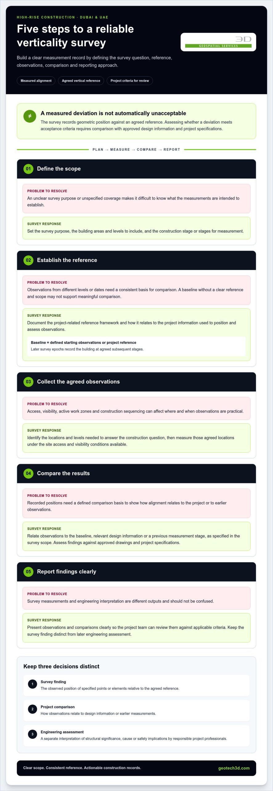
- Survey finding: the observed position of the specified points or elements relative to the agreed reference.
- Project comparison: how those observations relate to design information or earlier measurements.
- Engineering assessment: a separate interpretation of structural significance, cause, or safety implications.
Keeping these distinctions clear helps teams use survey results appropriately. Measurement documents geometry, project criteria guide acceptance, and structural diagnosis requires engineering assessment beyond the survey finding itself.
How High-Rise Verticality Measurements Build a Reliable Picture
Reliable findings come from a planned sequence, not isolated readings. For a verticality survey for high-rise construction, define the question to be answered, the building locations and levels to observe, and the information the project team needs. Then select a method that fits site conditions, visibility, access, and the required output.
- Define the scope. Set the survey purpose, areas to include, and construction stage or stages for measurement.
- Establish references. Document the project-related reference framework for positioning and assessing observations.
- Collect observations. Measure the agreed locations under the access and visibility conditions available on site.
- Compare results. Relate observations to the baseline, relevant design information, or a previous measurement stage, as specified in the scope.
- Report findings. Present the observations and comparison clearly so the project team can review them against approved criteria.
The baseline is the defined starting set of observations or project reference used for comparison. Later observations, sometimes called survey epochs, record the building at agreed subsequent stages. A baseline is not simply the first set of numbers available: its reference, locations, and scope must be clear enough to support meaningful comparison. The International Federation of Surveyors discusses high-rise measurement considerations in its guidance on Surveying Procedures for High-Rise Buildings.
Establishing references and planning measurement locations
Before fieldwork, document how the survey reference relates to project information and identify the locations and levels needed to answer the construction question. Site access, sightlines, active work zones, and sequencing can affect when and where observations are practical. Coordinate the planned work with construction activities so measurements can be made safely and the selected locations remain relevant as the structure progresses. Record the reference and scope alongside the observations.
Comparing observations across construction stages
Repeat observations are useful when their scope and reference basis are comparable. If locations or project stages change, record those differences so the comparison doesn’t imply a like-for-like change where none exists. A reported difference describes what the measurements show; it doesn’t establish why the difference occurred. Survey data alone can’t diagnose its cause.
Interpret findings using relevant project drawings and approved criteria. A clear report distinguishes the baseline from later observations, identifies the scope of each measurement stage, and presents the comparison for construction review. This supports informed coordination without treating survey findings as an engineering diagnosis.
For project teams in Dubai and the UAE, GEOTECH 3D’s surveying and geospatial services can support a measurement scope aligned with the construction decision and required information.
Choosing a Verticality Survey Approach for a Dubai High-Rise
The right approach depends on the project question, the areas to be observed, and site conditions. A focused set of survey observations may suit a defined location or construction check. 3D Scanning may be useful when the scope also calls for broader spatial context. Neither method is automatically right for every high-rise; let the requirements and intended output guide the decision.
Use the comparison below as a planning aid. It describes general approaches, not a specification for a particular project or a guarantee that one method will meet every requirement.
| Planning factor | Targeted survey observations | 3D scanning |
|---|---|---|
| Project question | Can defined locations or elements be checked at a particular stage? | Would broader building geometry provide useful context for review? |
| Coverage | Concentrates on specified points, elements, or areas. | Can document spatial information across the areas included in the scope. |
| Access | Depends on access and visibility to the selected observation locations. | Depends on access to the areas being captured and suitable lines of sight. |
| Repeatability | Can support comparison when locations and references are consistently defined. | Can support stage comparisons when scope and reference basis are consistent. |
| Intended output | Focused measurements for a specific verification or review need. | Spatial documentation that may support contextual assessment. |
When targeted survey observations may suit the project question
Focused observations can suit a need for information about defined locations, a particular construction stage, or a specific verification concern. For example, the scope might identify selected structural elements for comparison with project information. Start by stating the decision the measurement will support. This keeps the survey focused and avoids collecting observations that don’t answer the team’s question.
When 3D scanning can add spatial context
3D Scanning can document building geometry within a project-defined scope, giving teams spatial context for review alongside other project information. Its usefulness depends on which areas can be accessed, what needs to be represented, and how the information will be used. It doesn’t replace defining measurement locations or applicable acceptance criteria. For a related discussion of scanning in renovation contexts, see the guide to 3D Laser Scanning for Renovation in 2026.
In Dubai, method planning also needs to account for active works. Access windows, changing work zones, visibility, and coordination with contractors, consultants, and other stakeholders can affect when observations are practical. Aligning the survey plan with construction sequencing helps teams identify workable locations and stages while supporting site coordination.
For a verticality survey for high-rise construction, select the approach after defining the project question, site constraints, and required output. GEOTECH 3D provides Structural Survey and 3D Scanning to support project-specific assessment, with scope aligned to the intended construction review.
Planning Survey Scope, Tolerances, and Reporting for Construction Teams
A useful survey scope starts with a defined construction decision. Before a verticality survey for high-rise work begins, agree what needs to be measured, how findings will be assessed, and who will use the results. This prevents a report from presenting measurements without enough context for construction review.
Acceptance criteria must be project-defined and documented. Tolerances should come from approved design documents or project specifications, not generic rules of thumb. A measured deviation describes an observed position; comparison with the applicable project criteria helps determine whether it falls within the required limits.
What to define before a survey begins
Record the purpose and boundaries of the work before arranging measurements. The scope should give the survey team and reviewers a shared understanding of what is included and how the results will be used. A practical checklist includes:
- Purpose: State the construction decision or review the survey is intended to support.
- Locations: Identify the building areas, elements, and levels in scope.
- Stages: Specify the construction stage or stages when observations are required.
- References: Identify relevant approved drawings and reference information for comparison.
- Access: Record site access constraints, active work zones, and coordination requirements.
- Comparison: Define whether results will be assessed against design information, a baseline, or another agreed survey stage.
- Review and outputs: Agree the reporting format and identify the project stakeholders responsible for reviewing the findings.
These inputs also clarify what the survey will not answer. If access prevents observation of a specified location, or available project information limits a comparison, state that limitation in the report rather than leaving reviewers to infer it.
Making survey findings useful to project stakeholders
A concise report should connect each observation to an identifiable location and the reference used for assessment. It should distinguish measured findings from the comparison, any assumptions, and limitations affecting interpretation. This structure helps engineers, consultants, contractors, and project managers understand what the survey records without overstating what it proves.
Keep three decisions distinct. The survey documents geometric observations. The project team compares them with applicable drawings and acceptance criteria. Engineering professionals interpret structural significance and determine whether corrective action is needed. Survey findings alone don’t establish the cause of a deviation or prescribe a remedy.
Where the agreed scope includes 3D Documentation or Progress Monitoring, clarify how that information relates to the verticality review and construction records. GEOTECH 3D provides Structural Survey and 3D Scanning to support a project-defined scope, with reporting requirements aligned to the intended review.
How GEOTECH 3D Supports Project-Specific Verticality Survey Needs
GEOTECH 3D provides surveying capabilities that can be aligned with a project-defined verticality brief. Structural Survey and 3D Scanning can each contribute, depending on whether the project requires focused structural survey information, broader spatial documentation, or a coordinated combination. Match the selected capability to how the construction team intends to use the information rather than treating a method as a standard package.
Matching confirmed surveying capabilities to the project brief
Structural Survey is relevant when the brief centres on structural elements and their geometric review. 3D Scanning can contribute when documenting building geometry in context is useful to the assessment. These capabilities address different information needs, and the project question helps determine how they fit within the agreed scope.
Where construction records form part of the requirement, 3D Documentation can support record-keeping, while Progress Monitoring may be relevant to tracking project progress. Include these services in the verticality assessment only when they serve the brief. This keeps the relationship between survey information and wider construction documentation clear for project teams in Dubai and across the UAE.
Preparing a focused project enquiry
For an initial discussion, explain the alignment issue or review objective and how the team expects to use the resulting information. This helps frame whether Structural Survey, 3D Scanning, or related documentation capabilities are relevant. A concise description of the intended review gives stakeholders a shared starting point for coordinating surveying work with existing construction records and processes.
GEOTECH 3D can discuss a project-specific approach using its surveying and geospatial capabilities, without assuming a standard tolerance, instrument, or reporting format. The focus is on defining work that supports the intended construction review and the project’s information needs.
Set Your High-Rise Survey Up for Clear Decisions
Turn the current alignment question into a focused brief. Identify the decision the team needs to make, the construction stage when the information will be useful, and the project documents that will guide review. That clarity keeps the survey connected to coordination needs rather than collecting data without a defined purpose.
A verticality survey for high-rise construction is most valuable when findings can be understood in the context of the project. Bring relevant stakeholders into the scope discussion early, particularly where construction sequencing, site access, or review responsibilities affect the plan. GEOTECH 3D provides surveying services for project-specific approaches in Dubai and across the UAE, aligned with the brief and required information.
With a well-framed scope and clear project references, your team can make better-informed construction decisions using documented survey information.
Frequently Asked Questions
What is a verticality survey for a high-rise building?
It is a project survey focused on building alignment in the vertical plane. For clear communication, pair the term with the specific element or area under discussion, such as a core wall or a group of columns. Naming locations consistently in requests and review records helps colleagues connect survey findings to the right part of the building.
When should a high-rise verticality survey be carried out?
Choose timing according to when the information can influence a project decision. A planned review milestone may be more useful than an observation taken after the relevant coordination decision has passed. If the project expects several rounds of checks, agree their sequence in advance so results can inform construction reviews rather than remain disconnected survey events.
Can 3D laser scanning be used for a verticality survey?
Yes. 3D laser scanning can be used as part of a suitably defined survey scope. Consider how the captured information will be reviewed and whether it needs to relate to other project records. GEOTECH 3D provides 3D Scanning, and its role in a verticality assessment depends on the requirements of that project.
What information should a verticality survey report include?
Alongside the principal findings, useful report context can include the observation date, location identifiers that match project records, and the drawing revision used for comparison. Teams can also specify how limitations should be presented so reviewers don’t mistake an unobserved area for a confirmed result. Agreeing these conventions before the report is prepared makes review and record-keeping more straightforward.
Who sets the acceptable verticality tolerance for a high-rise?
The project’s approved design documents or specifications should establish the applicable acceptance criteria. If drawings and specifications appear to conflict, the project team should obtain direction from the responsible design authority before judging the survey results. Recording which criterion was used makes the review basis transparent and reduces the risk of stakeholders applying different interpretations to the same measurements.
Does a verticality survey replace structural monitoring or inspection?
No. A verticality survey addresses the geometric question defined for its scope; it isn’t a substitute for other assessment activities. Keep the purpose of each activity clear in project records and coordination discussions. If a survey raises a concern outside its scope, the responsible project professionals should determine the appropriate next review rather than infer it from survey results alone.
What should Dubai project teams prepare before requesting a survey?
Alongside a brief description of the request, provide the project’s naming conventions for areas and elements, the drawing revision currently used by the team, and the stakeholder who will review the information. These details help keep communication consistent across site and design teams. For a Dubai project, identify the site location clearly, particularly if project correspondence covers multiple sites across the UAE.
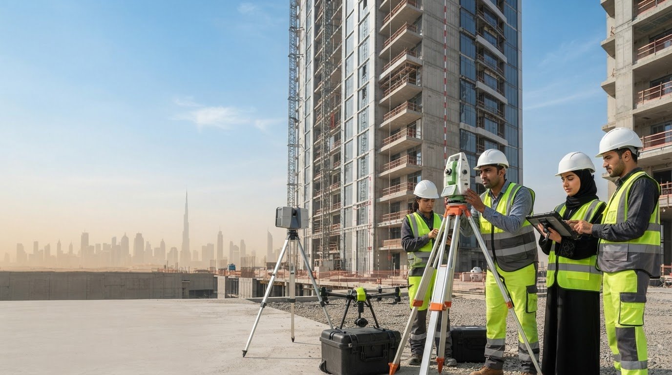
What if a measured deviation doesn’t mean a high-rise is outside tolerance? A verticality survey for high-rise construction compares a building’s observed alignment with an agreed vertical reference. The result supports a sound decision only when the measurement approach and acceptance criteria are clear. In Dubai, where construction teams need dependable information at each stage, that distinction matters.
Project teams need more than a set of measurements. They need to know when checks are useful, what the survey can establish, and how to compare a recorded deviation with approved drawings and specifications. This guide explains how verticality is assessed and how survey data can support construction review, coordination, and documentation.
Plan checks around construction stages, site access, and design requirements, then define a scope that produces actionable information. GEOTECH 3D provides surveying services, including Structural Survey, alongside 3D Scanning, 3D Documentation, and Progress Monitoring. These capabilities can support project-specific assessment in Dubai and across the UAE, with the measurement approach and deliverables aligned to the intended construction decision.
Key Takeaways
- A verticality survey for high-rise projects compares measured building alignment with an agreed vertical reference.
- Plan observations around the construction decision, project stage, site access, and required outputs.
- Targeted survey observations and 3D scanning offer different ways to address coverage and measurement needs.
- Use approved drawings and project specifications to assess deviations against the applicable criteria.
- Structural Survey, 3D Scanning, 3D Documentation, and Progress Monitoring can support project-defined assessment and construction records.
What a Verticality Survey for a High-Rise Building Measures
A verticality survey measures how a building’s observed position across the levels in scope aligns with an agreed vertical reference. It records geometric deviation for comparison with design information or earlier survey observations. The findings help project teams review alignment, but they don’t by themselves determine whether a structure is safe or identify the cause of a deviation.
The survey answers a specific question: where are the measured points or elements in relation to the intended vertical alignment? The reference framework matters because observations made at different levels or on different dates need a consistent basis for comparison. The general concepts of height, depth, and vertical position are outlined in Vertical Position.
Positional differences at individual levels can add up to a larger overall offset when viewed across a building’s height. For example, if successive structural elements do not align as intended, the resulting geometry may affect coordination of follow-on work against the design. Survey data makes those differences visible and recordable, rather than leaving teams to rely on visual impressions.
A measured deviation is not automatically unacceptable. Its significance depends on the location and element surveyed, the approved design information, and the acceptance criteria specified for the work. The survey establishes geometric information for review; engineers and other responsible project professionals interpret it within their roles.
Verticality, plumbness, and vertical control: what is the difference?
Verticality describes the overall alignment across the building levels included in the survey scope. Plumbness describes whether an element or line is vertically aligned, but checking one element does not necessarily show how the building aligns across multiple levels. Vertical control is the reference framework used to compare observations consistently and relate measured positions to the agreed project basis.
Why high-rise teams check alignment during construction
Checks can support construction verification, coordination, and documented project review at relevant stages. A visual observation may suggest a lean, but perspective, viewing position, and surrounding geometry make it unsuitable for establishing a measured deviation. A verticality survey for high-rise work provides recorded observations that can be assessed against design information and approved project criteria.
For construction teams in Dubai and across the UAE, tie the survey purpose to a decision: verifying alignment, reviewing an observed discrepancy, or recording geometry at a defined stage. A clear scope identifies the locations and levels to measure. The report can then distinguish survey findings from subsequent engineering interpretation.
- Survey finding: the observed position of the specified points or elements relative to the agreed reference.
- Project comparison: how those observations relate to design information or earlier measurements.
- Engineering assessment: a separate interpretation of structural significance, cause, or safety implications.
Keeping these distinctions clear helps teams use survey results appropriately. Measurement documents geometry, project criteria guide acceptance, and structural diagnosis requires engineering assessment beyond the survey finding itself.
How High-Rise Verticality Measurements Build a Reliable Picture
Reliable findings come from a planned sequence, not isolated readings. For a verticality survey for high-rise construction, define the question to be answered, the building locations and levels to observe, and the information the project team needs. Then select a method that fits site conditions, visibility, access, and the required output.
- Define the scope. Set the survey purpose, areas to include, and construction stage or stages for measurement.
- Establish references. Document the project-related reference framework for positioning and assessing observations.
- Collect observations. Measure the agreed locations under the access and visibility conditions available on site.
- Compare results. Relate observations to the baseline, relevant design information, or a previous measurement stage, as specified in the scope.
- Report findings. Present the observations and comparison clearly so the project team can review them against approved criteria.
The baseline is the defined starting set of observations or project reference used for comparison. Later observations, sometimes called survey epochs, record the building at agreed subsequent stages. A baseline is not simply the first set of numbers available: its reference, locations, and scope must be clear enough to support meaningful comparison. The International Federation of Surveyors discusses high-rise measurement considerations in its guidance on Surveying Procedures for High-Rise Buildings.
Establishing references and planning measurement locations
Before fieldwork, document how the survey reference relates to project information and identify the locations and levels needed to answer the construction question. Site access, sightlines, active work zones, and sequencing can affect when and where observations are practical. Coordinate the planned work with construction activities so measurements can be made safely and the selected locations remain relevant as the structure progresses. Record the reference and scope alongside the observations.
Comparing observations across construction stages
Repeat observations are useful when their scope and reference basis are comparable. If locations or project stages change, record those differences so the comparison doesn’t imply a like-for-like change where none exists. A reported difference describes what the measurements show; it doesn’t establish why the difference occurred. Survey data alone can’t diagnose its cause.
Interpret findings using relevant project drawings and approved criteria. A clear report distinguishes the baseline from later observations, identifies the scope of each measurement stage, and presents the comparison for construction review. This supports informed coordination without treating survey findings as an engineering diagnosis.
For project teams in Dubai and the UAE, GEOTECH 3D’s surveying and geospatial services can support a measurement scope aligned with the construction decision and required information.
Choosing a Verticality Survey Approach for a Dubai High-Rise
The right approach depends on the project question, the areas to be observed, and site conditions. A focused set of survey observations may suit a defined location or construction check. 3D Scanning may be useful when the scope also calls for broader spatial context. Neither method is automatically right for every high-rise; let the requirements and intended output guide the decision.
Use the comparison below as a planning aid. It describes general approaches, not a specification for a particular project or a guarantee that one method will meet every requirement.
| Planning factor | Targeted survey observations | 3D scanning |
|---|---|---|
| Project question | Can defined locations or elements be checked at a particular stage? | Would broader building geometry provide useful context for review? |
| Coverage | Concentrates on specified points, elements, or areas. | Can document spatial information across the areas included in the scope. |
| Access | Depends on access and visibility to the selected observation locations. | Depends on access to the areas being captured and suitable lines of sight. |
| Repeatability | Can support comparison when locations and references are consistently defined. | Can support stage comparisons when scope and reference basis are consistent. |
| Intended output | Focused measurements for a specific verification or review need. | Spatial documentation that may support contextual assessment. |
When targeted survey observations may suit the project question
Focused observations can suit a need for information about defined locations, a particular construction stage, or a specific verification concern. For example, the scope might identify selected structural elements for comparison with project information. Start by stating the decision the measurement will support. This keeps the survey focused and avoids collecting observations that don’t answer the team’s question.
When 3D scanning can add spatial context
3D Scanning can document building geometry within a project-defined scope, giving teams spatial context for review alongside other project information. Its usefulness depends on which areas can be accessed, what needs to be represented, and how the information will be used. It doesn’t replace defining measurement locations or applicable acceptance criteria. For a related discussion of scanning in renovation contexts, see the guide to 3D Laser Scanning for Renovation in 2026.
In Dubai, method planning also needs to account for active works. Access windows, changing work zones, visibility, and coordination with contractors, consultants, and other stakeholders can affect when observations are practical. Aligning the survey plan with construction sequencing helps teams identify workable locations and stages while supporting site coordination.
For a verticality survey for high-rise construction, select the approach after defining the project question, site constraints, and required output. GEOTECH 3D provides Structural Survey and 3D Scanning to support project-specific assessment, with scope aligned to the intended construction review.
Planning Survey Scope, Tolerances, and Reporting for Construction Teams
A useful survey scope starts with a defined construction decision. Before a verticality survey for high-rise work begins, agree what needs to be measured, how findings will be assessed, and who will use the results. This prevents a report from presenting measurements without enough context for construction review.
Acceptance criteria must be project-defined and documented. Tolerances should come from approved design documents or project specifications, not generic rules of thumb. A measured deviation describes an observed position; comparison with the applicable project criteria helps determine whether it falls within the required limits.
What to define before a survey begins
Record the purpose and boundaries of the work before arranging measurements. The scope should give the survey team and reviewers a shared understanding of what is included and how the results will be used. A practical checklist includes:
- Purpose: State the construction decision or review the survey is intended to support.
- Locations: Identify the building areas, elements, and levels in scope.
- Stages: Specify the construction stage or stages when observations are required.
- References: Identify relevant approved drawings and reference information for comparison.
- Access: Record site access constraints, active work zones, and coordination requirements.
- Comparison: Define whether results will be assessed against design information, a baseline, or another agreed survey stage.
- Review and outputs: Agree the reporting format and identify the project stakeholders responsible for reviewing the findings.
These inputs also clarify what the survey will not answer. If access prevents observation of a specified location, or available project information limits a comparison, state that limitation in the report rather than leaving reviewers to infer it.
Making survey findings useful to project stakeholders
A concise report should connect each observation to an identifiable location and the reference used for assessment. It should distinguish measured findings from the comparison, any assumptions, and limitations affecting interpretation. This structure helps engineers, consultants, contractors, and project managers understand what the survey records without overstating what it proves.
Keep three decisions distinct. The survey documents geometric observations. The project team compares them with applicable drawings and acceptance criteria. Engineering professionals interpret structural significance and determine whether corrective action is needed. Survey findings alone don’t establish the cause of a deviation or prescribe a remedy.
Where the agreed scope includes 3D Documentation or Progress Monitoring, clarify how that information relates to the verticality review and construction records. GEOTECH 3D provides Structural Survey and 3D Scanning to support a project-defined scope, with reporting requirements aligned to the intended review.
How GEOTECH 3D Supports Project-Specific Verticality Survey Needs
GEOTECH 3D provides surveying capabilities that can be aligned with a project-defined verticality brief. Structural Survey and 3D Scanning can each contribute, depending on whether the project requires focused structural survey information, broader spatial documentation, or a coordinated combination. Match the selected capability to how the construction team intends to use the information rather than treating a method as a standard package.
Matching confirmed surveying capabilities to the project brief
Structural Survey is relevant when the brief centres on structural elements and their geometric review. 3D Scanning can contribute when documenting building geometry in context is useful to the assessment. These capabilities address different information needs, and the project question helps determine how they fit within the agreed scope.
Where construction records form part of the requirement, 3D Documentation can support record-keeping, while Progress Monitoring may be relevant to tracking project progress. Include these services in the verticality assessment only when they serve the brief. This keeps the relationship between survey information and wider construction documentation clear for project teams in Dubai and across the UAE.
Preparing a focused project enquiry
For an initial discussion, explain the alignment issue or review objective and how the team expects to use the resulting information. This helps frame whether Structural Survey, 3D Scanning, or related documentation capabilities are relevant. A concise description of the intended review gives stakeholders a shared starting point for coordinating surveying work with existing construction records and processes.
GEOTECH 3D can discuss a project-specific approach using its surveying and geospatial capabilities, without assuming a standard tolerance, instrument, or reporting format. The focus is on defining work that supports the intended construction review and the project’s information needs.
Set Your High-Rise Survey Up for Clear Decisions
Turn the current alignment question into a focused brief. Identify the decision the team needs to make, the construction stage when the information will be useful, and the project documents that will guide review. That clarity keeps the survey connected to coordination needs rather than collecting data without a defined purpose.
A verticality survey for high-rise construction is most valuable when findings can be understood in the context of the project. Bring relevant stakeholders into the scope discussion early, particularly where construction sequencing, site access, or review responsibilities affect the plan. GEOTECH 3D provides surveying services for project-specific approaches in Dubai and across the UAE, aligned with the brief and required information.
With a well-framed scope and clear project references, your team can make better-informed construction decisions using documented survey information.
Frequently Asked Questions
What is a verticality survey for a high-rise building?
It is a project survey focused on building alignment in the vertical plane. For clear communication, pair the term with the specific element or area under discussion, such as a core wall or a group of columns. Naming locations consistently in requests and review records helps colleagues connect survey findings to the right part of the building.
When should a high-rise verticality survey be carried out?
Choose timing according to when the information can influence a project decision. A planned review milestone may be more useful than an observation taken after the relevant coordination decision has passed. If the project expects several rounds of checks, agree their sequence in advance so results can inform construction reviews rather than remain disconnected survey events.
Can 3D laser scanning be used for a verticality survey?
Yes. 3D laser scanning can be used as part of a suitably defined survey scope. Consider how the captured information will be reviewed and whether it needs to relate to other project records. GEOTECH 3D provides 3D Scanning, and its role in a verticality assessment depends on the requirements of that project.
What information should a verticality survey report include?
Alongside the principal findings, useful report context can include the observation date, location identifiers that match project records, and the drawing revision used for comparison. Teams can also specify how limitations should be presented so reviewers don’t mistake an unobserved area for a confirmed result. Agreeing these conventions before the report is prepared makes review and record-keeping more straightforward.
Who sets the acceptable verticality tolerance for a high-rise?
The project’s approved design documents or specifications should establish the applicable acceptance criteria. If drawings and specifications appear to conflict, the project team should obtain direction from the responsible design authority before judging the survey results. Recording which criterion was used makes the review basis transparent and reduces the risk of stakeholders applying different interpretations to the same measurements.
Does a verticality survey replace structural monitoring or inspection?
No. A verticality survey addresses the geometric question defined for its scope; it isn’t a substitute for other assessment activities. Keep the purpose of each activity clear in project records and coordination discussions. If a survey raises a concern outside its scope, the responsible project professionals should determine the appropriate next review rather than infer it from survey results alone.
What should Dubai project teams prepare before requesting a survey?
Alongside a brief description of the request, provide the project’s naming conventions for areas and elements, the drawing revision currently used by the team, and the stakeholder who will review the information. These details help keep communication consistent across site and design teams. For a Dubai project, identify the site location clearly, particularly if project correspondence covers multiple sites across the UAE.
Search Now
Error: Contact form not found.