

Our Services
Cadastral Surveying in Saudi Arabia: From Parcel Data to Usable Land Information
Accurate parcel measurements are only useful when the resulting information answers the project’s questions. For teams in Dubai and the UAE working with Saudi Arabia project data, the jurisdiction and intended use shape the scope. Cadastral surveying Saudi Arabia projects should be planned around their specific requirements, not assumed to follow the same processes as work in the UAE.
Cadastral mapping focuses on parcels and related spatial information. A land survey or topographic survey can address different site conditions, so the right scope depends on what the team needs to plan, coordinate or manage. Defining the purpose and required outputs early helps avoid gaps between the survey data and its intended use.
This article explains what cadastral mapping can show, how it fits into a broader land-information workflow and what to clarify before fieldwork. You’ll learn how survey types differ, which records and outputs to consider, and how to prepare a practical project brief. In Dubai and the UAE, GEOTECH 3D provides Cadastral Mapping as part of its GIS & Surveying Services, alongside Land Survey, Topographic Mapping and Spatial Analysis.
Key Takeaways
- Understand how cadastral mapping represents parcels and related spatial information for land planning and management.
- See how field observations and relevant project records can be organized in a GIS dataset for viewing and analysis.
- Distinguish cadastral mapping from topographic mapping, land surveys and official reporting by the questions each addresses.
- Plan cadastral surveying Saudi Arabia projects by defining the intended use and project limits, then assembling relevant plans, parcel references and records.
- Explore how GEOTECH 3D’s Cadastral Mapping connects with Land Survey, Topographic Mapping and Spatial Analysis within GIS & Surveying Services.
What Cadastral Surveying in Saudi Arabia Records, and Why It Matters
Cadastral surveying maps land parcels and associated spatial information, such as parcel geometry and observations related to boundaries. It shows how parcels are positioned in relation to nearby land and other mapped information. A cadastre provides a structured context for land information. For background, see What is a Cadastre? For projects in Dubai and the UAE, the intended use and applicable jurisdiction shape the survey scope and how its outputs are used.
For a development team, parcel information establishes spatial context for planning, design coordination and property management. Clear parcel identification helps teams relate plans and site information to the land area under consideration. Comparing parcel data with a project plan can also reveal items that need technical review, such as a difference between the mapped outline and the planned site boundary.
Survey data describes spatial observations. On its own, it does not determine ownership or establish a parcel’s legal status. Those matters depend on the relevant records and official processes for the jurisdiction. Keep the technical mapping scope distinct from any legal or administrative process that applies to the project, whether the work is in Saudi Arabia, Dubai or elsewhere in the UAE.
What information does a cadastral survey capture?
The project brief and applicable requirements determine the scope. Depending on the assignment, cadastral work may document:
- Parcel geometry: The mapped shape and position of a parcel within the project area.
- Boundary-related observations: Spatial information gathered to describe or review boundary locations in context.
- Spatial relationships: How parcels relate to adjacent areas, site plans or other mapped information.
Available plans, parcel references and project records can inform the work, but their relevance depends on the assignment. Before fieldwork, clarify the project limits, intended use and expected outputs. Also identify the questions the dataset needs to answer, such as whether it is being prepared for land management, development planning or comparison with other mapped information. This makes it easier to align fieldwork and spatial review with the project’s actual needs.
Cadastral mapping versus land and topographic surveys
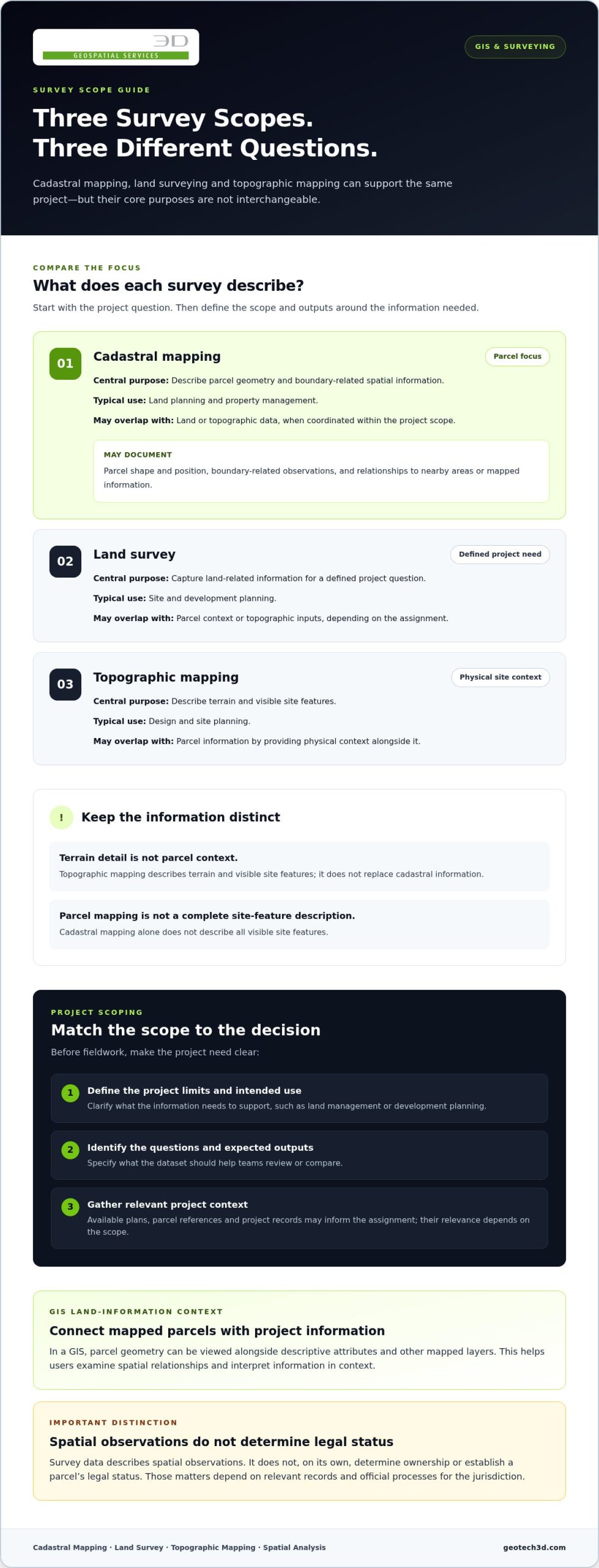
These survey types can contribute to the same project, but they address different questions. Cadastral mapping focuses on parcels. A land survey captures land-related information for a defined project need. Topographic mapping describes terrain and visible site features. The precise scope of each depends on the assignment.
| Survey type | Central purpose | Typical use | Potential overlap |
|---|---|---|---|
| Cadastral mapping | Describe parcel geometry and boundary-related spatial information | Land planning and property management | May be coordinated with land or topographic data |
| Land survey | Capture land information for a defined project question | Site and development planning | May include parcel context or topographic inputs, depending on scope |
| Topographic mapping | Describe terrain and visible site features | Design and site planning | Can provide physical context alongside parcel information |
A project may need coordinated scopes to connect parcel information with ground conditions. Treating the outputs as interchangeable can leave gaps: terrain detail does not establish parcel context, and parcel mapping alone does not describe all visible site features. For projects in Dubai and the UAE, define the decision the information must support, then align each survey component with the relevant project requirements.
How Cadastral Surveying Becomes a GIS Land-Information Dataset
Field observations become more useful when they are connected to a clear project purpose and organized for review. Cadastral surveying is part of a workflow that relates mapped parcel information to project records and other spatial data. Defining the intended use early helps teams shape the data workflow around the requirements of the project in Saudi Arabia, Dubai or elsewhere in the UAE.
Cadastral mapping is a spatial representation of land parcels and associated information. In a GIS, parcel geometry can be viewed alongside descriptive attributes and other mapped layers. This lets users examine spatial relationships and interpret information in context. It also helps keep a technical dataset distinct from official legal or administrative records.
From project brief and records to field observations
Start by defining the project area and intended use. A dataset prepared to support land management may need a different level of detail from one coordinated with a development plan. Identify the questions the mapping should help address, the information already available and any constraints on how the results will be reviewed or used.
Existing plans, parcel references and project records can provide context for fieldwork. Their relevance depends on the assignment, so do not assume that one document is required for every project. Comparing available information with observed site conditions can bring inconsistencies or gaps into view. For example, a mapped parcel outline may not align with a project plan. That difference is a prompt for technical review, not a conclusion about ownership or legal status.
Plan field data capture around the agreed scope. The observations and methods depend on the site, the information required and the project brief. During review, check how the observations relate to available records and whether the resulting spatial information answers the intended questions. Connecting scope, records, fieldwork and review helps produce a coherent cadastral dataset.
How GIS supports cadastral information
GIS organizes spatial features and associated information in a structured environment. Parcel geometry can be represented alongside relevant attributes, with other project layers included where they help users understand location and context. Users can view and compare layers, query information and carry out spatial analysis suited to the project’s purpose.
This structure can support land-management workflows by making parcel-related information easier to examine alongside other spatial data. It does not turn survey observations into a legal determination or replace official administrative records. The dataset remains a technical information resource, with its role defined by the project and applicable processes.
For projects in Dubai and the UAE, coordinate reference systems, data schemas and required formats should match verified project requirements and intended use. Establish these parameters before processing so the data is prepared for its planned application. GEOTECH 3D’s GIS & Surveying Services include cadastral mapping and other spatial information services.
Cadastral Survey, Topographic Survey, or Official Report: Which Need Are You Addressing?
These terms may appear together in a land project, but they describe different purposes. Cadastral mapping organizes parcel-related spatial information. Topographic mapping describes terrain and visible site features. A land survey is scoped around a defined land-related project need. An official report belongs to an administrative process. A technical survey dataset should not be treated as automatic approval, proof of ownership or a substitute for a document issued through the applicable process.
A technical cadastral dataset describes spatial information about land parcels; an authority-issued document serves a separate administrative purpose under the applicable process. This distinction matters for cadastral surveying Saudi Arabia projects, where submission and reporting requirements depend on the project and jurisdiction. Define the technical output separately from any official document or administrative decision required for the project.
| Work type | Central purpose | Likely stakeholder | Question it helps answer |
|---|---|---|---|
| Cadastral mapping | Represent parcel-related geometry and spatial information | Land-information, development or property-management teams | How are parcels represented and related spatially? |
| Topographic mapping | Describe terrain and visible site features | Designers, engineers and project planners | What ground conditions and features need to inform planning? |
| Land survey | Capture land information for a defined project scope | Developers, contractors or consultants | What land information does this project need? |
| Official report process | Produce an administrative document through the applicable process | Applicants or parties to the relevant process | What document or decision does that process provide? |
When a project needs cadastral mapping
Cadastral mapping is relevant when a project needs parcel-focused spatial information, such as for land-information work, real-estate development planning or parcel-related spatial analysis. It organizes mapped parcel information for technical review and use alongside other project data. GEOTECH 3D provides Cadastral Mapping within its GIS & Surveying Services in Dubai and the UAE. This technical scope can be coordinated with related land-information work, but it does not adjudicate boundaries, verify title or secure registration.
When topographic or official documentation needs a separate scope
If design or planning depends on terrain and visible site features, topographic mapping addresses a different information need from parcel mapping. A project may require both, but their purposes should be clear in the scope. Similarly, an administrative report and a technical survey dataset may relate to the same land, but they are not interchangeable deliverables.
Before work begins, identify whether the project needs mapped parcel information, terrain data, an official document or a coordinated combination. For a Saudi submission, define the technical survey scope separately from the administrative process. This keeps expectations clear and avoids treating survey data as a determination of an official outcome.
How to Prepare a Cadastral Survey Project in Saudi Arabia
A reliable project starts with a defined purpose and a clear boundary for the work. For cadastral surveying Saudi Arabia projects, preparation means separating confirmed technical requirements from details that depend on the project process or relevant stakeholders. This gives the survey team a basis for planning records review, site access, fieldwork and GIS outputs.
Define the purpose, area, and expected use
State whether the information will support development planning, land management, parcel-related analysis or another specific need. Record the project extent and known parcel references, then assemble relevant plans, previous survey information and available project records. These materials can inform the scope, but their relevance depends on the assignment.
Coordinate fieldwork, records, and deliverables
Before collection begins, coordinate site access with the project team and identify operational constraints that could affect fieldwork. Agree on who will provide records, who will review the mapped information and how questions or discrepancies will be handled. Define expected outputs in practical terms, including how the GIS information will be used and which coordinate reference, data schema and file formats apply. Set these requirements against the project’s applicable criteria rather than relying on assumptions.
- Set the intended use and project boundary. Describe the decision or workflow the survey will support, identify the mapped area and note known parcel references.
- Gather available information. Compile relevant plans, existing survey information, parcel references and project records. Treat these as useful inputs, not documents that every project must have.
- Separate confirmed requirements from open questions. Record what the project team has agreed and list technical or administrative details that still need clarification through the applicable project process.
- Plan site access and coordination. Identify access arrangements, site constraints and the stakeholders involved in providing information or reviewing results. These factors shape fieldwork planning and scheduling.
- Agree on data and deliverables. Define the required GIS outputs, level of detail, coordinate reference and formats against the project’s requirements before processing begins.
Use this checklist during planning:
- The purpose and project limits are documented.
- Available parcel references, plans and records are assembled.
- Site access and stakeholder coordination are addressed.
- GIS outputs and technical requirements are defined or flagged for clarification.
- Any jurisdiction-specific submission criteria are incorporated into the project brief.
For projects in Dubai, real-estate strata mapping is a distinct property-related scope. Describe it according to its intended use rather than treating it as a synonym for cadastral mapping. Clear scope-setting keeps land-information tasks aligned with the project’s actual needs.
GEOTECH 3D Cadastral Mapping for Saudi Arabia Projects
Land-information work benefits from a technical scope shaped around the site, intended use and available project records. GEOTECH 3D provides Cadastral Mapping within its GIS & Surveying Services in Dubai and the UAE. For teams planning a Saudi Arabia project, the same scoping principles help clarify the parcel information required, while the applicable project requirements determine how that information is used.
GEOTECH 3D’s regional service offering includes cadastral mapping, land survey, topographic mapping and spatial analysis. These are technical geospatial services, not a statement of approval or acceptance by a particular authority. Any authority-specific process or decision is separate from the survey scope and should be accounted for in the project requirements.
A geospatial scope aligned with project requirements
Start by defining what the mapped information needs to support. A land-information project may focus on parcel-related spatial data, while a broader site assignment may also need Land Survey or Topographic Mapping. Spatial Analysis can help relate mapped information to project questions. GEOTECH 3D offers these capabilities within its GIS & Surveying Services, allowing the technical brief to identify which land-information components the project needs.
A clear scope supports useful spatial information. Set out the project extent, available records, intended use and expected outputs, then distinguish technical requirements from any separate submission or administrative process. Coordinate references, data structure and formats should follow the project’s defined requirements. This keeps the mapping focused and helps teams understand what the dataset represents without presenting it as a legal determination or official decision.
For example, a team assembling parcel information for planning may need cadastral mapping as its central scope. If terrain or visible site features also inform design, Topographic Mapping may form a related but distinct component. The project brief should make those purposes clear so each dataset contributes relevant information without being treated as interchangeable.
Discuss your cadastral mapping requirements
Bring the site extent, intended use, available plans or parcel references and the spatial information your team needs into the project discussion. These details help frame a technical mapping scope and identify whether related Land Survey, Topographic Mapping or Spatial Analysis may be relevant. For Dubai property subdivisions, real-estate strata is a distinct context and should be scoped according to its own purpose.
GEOTECH 3D’s Cadastral Mapping is part of its GIS & Surveying Services for projects in Dubai and the UAE. The project brief should set out the required information and intended use.
Turn Your Land-Information Needs Into a Clear Project Brief
Translate the project’s intended use into a focused technical scope. For cadastral surveying Saudi Arabia, early alignment on the site, required spatial information and applicable project requirements helps teams plan fieldwork and data review. Keep technical mapping objectives distinct from any administrative process, and include unresolved requirements as items to clarify through the relevant project channels.
A well-framed brief gives geospatial work a practical direction. It explains what information the team needs, how it will be used and where related survey inputs may contribute. With those priorities established, parcel data can support broader land-information planning while the purpose and limits of each output remain clear.
GEOTECH 3D provides Cadastral Mapping and related GIS & Surveying Services in Dubai and the UAE. Share your project scope and land-information requirements to discuss a suitable technical approach.
Frequently Asked Questions
What is cadastral surveying in Saudi Arabia?
Cadastral surveying in Saudi Arabia maps land parcels and related spatial information for land management, development and property-related workflows. A project team might use parcel context when coordinating site planning with other land information. The technical dataset records spatial information; it does not itself issue an official cadastral report or make a legal decision. Requirements depend on the project and applicable jurisdiction.
Is cadastral surveying the same as a topographic survey?
No. Cadastral work focuses on spatial information associated with parcels, while topographic work describes terrain and site features relevant to design. A development project may need parcel context, terrain data or both. The project brief determines how the scopes fit together. Neither dataset replaces official records or, by itself, adjudicates legal boundaries.
Can a cadastral survey confirm legal ownership in Saudi Arabia?
No. A cadastral survey is technical mapping, not a legal determination of ownership. Ownership and official records are addressed through the applicable legal and administrative processes for the project. Survey data may contribute spatial information to a wider workflow, but it does not by itself guarantee registration, approval or a particular decision. Keep those administrative outcomes distinct from the mapping scope.
What information should I prepare before a cadastral survey?
Prepare the project purpose, site extent, available plans or parcel references, existing survey information, site-access details and intended use of the outputs. For example, note whether the information will support planning or land management and who will review it. These are useful planning inputs, not universal legal requirements. The final scope depends on the project and its applicable requirements.
How is cadastral mapping used in land management?
Cadastral mapping can support land management by organizing parcel-related geometry and associated information in GIS for viewing and analysis. A project team could examine parcel information alongside relevant planning layers to understand spatial relationships. The dataset’s usefulness depends on its scope, source information and alignment with project requirements. It does not guarantee an administrative result or replace official records.
What deliverables can a cadastral surveying project provide?
Deliverables depend on the agreed scope and project requirements. A project may produce mapped spatial information or GIS data where specified, allowing the team to use parcel-related information in its technical workflow. Define the required file type, coordinate system and level of detail in the project brief rather than assuming a standard output. Technical deliverables are separate from official reports or records issued through administrative processes.
How long does cadastral surveying take in Saudi Arabia?
There is no single duration that applies to every project. Timing depends on factors such as site extent, access arrangements, available information, fieldwork needs and agreed deliverables. A clearly defined scope helps the project team establish a schedule suited to those conditions. For cadastral surveying in Saudi Arabia, include applicable project requirements in the planning brief instead of relying on a generic turnaround estimate.

Accurate parcel measurements are only useful when the resulting information answers the project’s questions. For teams in Dubai and the UAE working with Saudi Arabia project data, the jurisdiction and intended use shape the scope. Cadastral surveying Saudi Arabia projects should be planned around their specific requirements, not assumed to follow the same processes as work in the UAE.
Cadastral mapping focuses on parcels and related spatial information. A land survey or topographic survey can address different site conditions, so the right scope depends on what the team needs to plan, coordinate or manage. Defining the purpose and required outputs early helps avoid gaps between the survey data and its intended use.
This article explains what cadastral mapping can show, how it fits into a broader land-information workflow and what to clarify before fieldwork. You’ll learn how survey types differ, which records and outputs to consider, and how to prepare a practical project brief. In Dubai and the UAE, GEOTECH 3D provides Cadastral Mapping as part of its GIS & Surveying Services, alongside Land Survey, Topographic Mapping and Spatial Analysis.
Key Takeaways
- Understand how cadastral mapping represents parcels and related spatial information for land planning and management.
- See how field observations and relevant project records can be organized in a GIS dataset for viewing and analysis.
- Distinguish cadastral mapping from topographic mapping, land surveys and official reporting by the questions each addresses.
- Plan cadastral surveying Saudi Arabia projects by defining the intended use and project limits, then assembling relevant plans, parcel references and records.
- Explore how GEOTECH 3D’s Cadastral Mapping connects with Land Survey, Topographic Mapping and Spatial Analysis within GIS & Surveying Services.
What Cadastral Surveying in Saudi Arabia Records, and Why It Matters
Cadastral surveying maps land parcels and associated spatial information, such as parcel geometry and observations related to boundaries. It shows how parcels are positioned in relation to nearby land and other mapped information. A cadastre provides a structured context for land information. For background, see What is a Cadastre? For projects in Dubai and the UAE, the intended use and applicable jurisdiction shape the survey scope and how its outputs are used.
For a development team, parcel information establishes spatial context for planning, design coordination and property management. Clear parcel identification helps teams relate plans and site information to the land area under consideration. Comparing parcel data with a project plan can also reveal items that need technical review, such as a difference between the mapped outline and the planned site boundary.
Survey data describes spatial observations. On its own, it does not determine ownership or establish a parcel’s legal status. Those matters depend on the relevant records and official processes for the jurisdiction. Keep the technical mapping scope distinct from any legal or administrative process that applies to the project, whether the work is in Saudi Arabia, Dubai or elsewhere in the UAE.
What information does a cadastral survey capture?
The project brief and applicable requirements determine the scope. Depending on the assignment, cadastral work may document:
- Parcel geometry: The mapped shape and position of a parcel within the project area.
- Boundary-related observations: Spatial information gathered to describe or review boundary locations in context.
- Spatial relationships: How parcels relate to adjacent areas, site plans or other mapped information.
Available plans, parcel references and project records can inform the work, but their relevance depends on the assignment. Before fieldwork, clarify the project limits, intended use and expected outputs. Also identify the questions the dataset needs to answer, such as whether it is being prepared for land management, development planning or comparison with other mapped information. This makes it easier to align fieldwork and spatial review with the project’s actual needs.
Cadastral mapping versus land and topographic surveys
These survey types can contribute to the same project, but they address different questions. Cadastral mapping focuses on parcels. A land survey captures land-related information for a defined project need. Topographic mapping describes terrain and visible site features. The precise scope of each depends on the assignment.
| Survey type | Central purpose | Typical use | Potential overlap |
|---|---|---|---|
| Cadastral mapping | Describe parcel geometry and boundary-related spatial information | Land planning and property management | May be coordinated with land or topographic data |
| Land survey | Capture land information for a defined project question | Site and development planning | May include parcel context or topographic inputs, depending on scope |
| Topographic mapping | Describe terrain and visible site features | Design and site planning | Can provide physical context alongside parcel information |
A project may need coordinated scopes to connect parcel information with ground conditions. Treating the outputs as interchangeable can leave gaps: terrain detail does not establish parcel context, and parcel mapping alone does not describe all visible site features. For projects in Dubai and the UAE, define the decision the information must support, then align each survey component with the relevant project requirements.
How Cadastral Surveying Becomes a GIS Land-Information Dataset
Field observations become more useful when they are connected to a clear project purpose and organized for review. Cadastral surveying is part of a workflow that relates mapped parcel information to project records and other spatial data. Defining the intended use early helps teams shape the data workflow around the requirements of the project in Saudi Arabia, Dubai or elsewhere in the UAE.
Cadastral mapping is a spatial representation of land parcels and associated information. In a GIS, parcel geometry can be viewed alongside descriptive attributes and other mapped layers. This lets users examine spatial relationships and interpret information in context. It also helps keep a technical dataset distinct from official legal or administrative records.
From project brief and records to field observations
Start by defining the project area and intended use. A dataset prepared to support land management may need a different level of detail from one coordinated with a development plan. Identify the questions the mapping should help address, the information already available and any constraints on how the results will be reviewed or used.
Existing plans, parcel references and project records can provide context for fieldwork. Their relevance depends on the assignment, so do not assume that one document is required for every project. Comparing available information with observed site conditions can bring inconsistencies or gaps into view. For example, a mapped parcel outline may not align with a project plan. That difference is a prompt for technical review, not a conclusion about ownership or legal status.
Plan field data capture around the agreed scope. The observations and methods depend on the site, the information required and the project brief. During review, check how the observations relate to available records and whether the resulting spatial information answers the intended questions. Connecting scope, records, fieldwork and review helps produce a coherent cadastral dataset.
How GIS supports cadastral information
GIS organizes spatial features and associated information in a structured environment. Parcel geometry can be represented alongside relevant attributes, with other project layers included where they help users understand location and context. Users can view and compare layers, query information and carry out spatial analysis suited to the project’s purpose.
This structure can support land-management workflows by making parcel-related information easier to examine alongside other spatial data. It does not turn survey observations into a legal determination or replace official administrative records. The dataset remains a technical information resource, with its role defined by the project and applicable processes.
For projects in Dubai and the UAE, coordinate reference systems, data schemas and required formats should match verified project requirements and intended use. Establish these parameters before processing so the data is prepared for its planned application. GEOTECH 3D’s GIS & Surveying Services include cadastral mapping and other spatial information services.
Cadastral Survey, Topographic Survey, or Official Report: Which Need Are You Addressing?
These terms may appear together in a land project, but they describe different purposes. Cadastral mapping organizes parcel-related spatial information. Topographic mapping describes terrain and visible site features. A land survey is scoped around a defined land-related project need. An official report belongs to an administrative process. A technical survey dataset should not be treated as automatic approval, proof of ownership or a substitute for a document issued through the applicable process.
A technical cadastral dataset describes spatial information about land parcels; an authority-issued document serves a separate administrative purpose under the applicable process. This distinction matters for cadastral surveying Saudi Arabia projects, where submission and reporting requirements depend on the project and jurisdiction. Define the technical output separately from any official document or administrative decision required for the project.
| Work type | Central purpose | Likely stakeholder | Question it helps answer |
|---|---|---|---|
| Cadastral mapping | Represent parcel-related geometry and spatial information | Land-information, development or property-management teams | How are parcels represented and related spatially? |
| Topographic mapping | Describe terrain and visible site features | Designers, engineers and project planners | What ground conditions and features need to inform planning? |
| Land survey | Capture land information for a defined project scope | Developers, contractors or consultants | What land information does this project need? |
| Official report process | Produce an administrative document through the applicable process | Applicants or parties to the relevant process | What document or decision does that process provide? |
When a project needs cadastral mapping
Cadastral mapping is relevant when a project needs parcel-focused spatial information, such as for land-information work, real-estate development planning or parcel-related spatial analysis. It organizes mapped parcel information for technical review and use alongside other project data. GEOTECH 3D provides Cadastral Mapping within its GIS & Surveying Services in Dubai and the UAE. This technical scope can be coordinated with related land-information work, but it does not adjudicate boundaries, verify title or secure registration.
When topographic or official documentation needs a separate scope
If design or planning depends on terrain and visible site features, topographic mapping addresses a different information need from parcel mapping. A project may require both, but their purposes should be clear in the scope. Similarly, an administrative report and a technical survey dataset may relate to the same land, but they are not interchangeable deliverables.
Before work begins, identify whether the project needs mapped parcel information, terrain data, an official document or a coordinated combination. For a Saudi submission, define the technical survey scope separately from the administrative process. This keeps expectations clear and avoids treating survey data as a determination of an official outcome.
How to Prepare a Cadastral Survey Project in Saudi Arabia
A reliable project starts with a defined purpose and a clear boundary for the work. For cadastral surveying Saudi Arabia projects, preparation means separating confirmed technical requirements from details that depend on the project process or relevant stakeholders. This gives the survey team a basis for planning records review, site access, fieldwork and GIS outputs.
Define the purpose, area, and expected use
State whether the information will support development planning, land management, parcel-related analysis or another specific need. Record the project extent and known parcel references, then assemble relevant plans, previous survey information and available project records. These materials can inform the scope, but their relevance depends on the assignment.
Coordinate fieldwork, records, and deliverables
Before collection begins, coordinate site access with the project team and identify operational constraints that could affect fieldwork. Agree on who will provide records, who will review the mapped information and how questions or discrepancies will be handled. Define expected outputs in practical terms, including how the GIS information will be used and which coordinate reference, data schema and file formats apply. Set these requirements against the project’s applicable criteria rather than relying on assumptions.
- Set the intended use and project boundary. Describe the decision or workflow the survey will support, identify the mapped area and note known parcel references.
- Gather available information. Compile relevant plans, existing survey information, parcel references and project records. Treat these as useful inputs, not documents that every project must have.
- Separate confirmed requirements from open questions. Record what the project team has agreed and list technical or administrative details that still need clarification through the applicable project process.
- Plan site access and coordination. Identify access arrangements, site constraints and the stakeholders involved in providing information or reviewing results. These factors shape fieldwork planning and scheduling.
- Agree on data and deliverables. Define the required GIS outputs, level of detail, coordinate reference and formats against the project’s requirements before processing begins.
Use this checklist during planning:
- The purpose and project limits are documented.
- Available parcel references, plans and records are assembled.
- Site access and stakeholder coordination are addressed.
- GIS outputs and technical requirements are defined or flagged for clarification.
- Any jurisdiction-specific submission criteria are incorporated into the project brief.
For projects in Dubai, real-estate strata mapping is a distinct property-related scope. Describe it according to its intended use rather than treating it as a synonym for cadastral mapping. Clear scope-setting keeps land-information tasks aligned with the project’s actual needs.
GEOTECH 3D Cadastral Mapping for Saudi Arabia Projects
Land-information work benefits from a technical scope shaped around the site, intended use and available project records. GEOTECH 3D provides Cadastral Mapping within its GIS & Surveying Services in Dubai and the UAE. For teams planning a Saudi Arabia project, the same scoping principles help clarify the parcel information required, while the applicable project requirements determine how that information is used.
GEOTECH 3D’s regional service offering includes cadastral mapping, land survey, topographic mapping and spatial analysis. These are technical geospatial services, not a statement of approval or acceptance by a particular authority. Any authority-specific process or decision is separate from the survey scope and should be accounted for in the project requirements.
A geospatial scope aligned with project requirements
Start by defining what the mapped information needs to support. A land-information project may focus on parcel-related spatial data, while a broader site assignment may also need Land Survey or Topographic Mapping. Spatial Analysis can help relate mapped information to project questions. GEOTECH 3D offers these capabilities within its GIS & Surveying Services, allowing the technical brief to identify which land-information components the project needs.
A clear scope supports useful spatial information. Set out the project extent, available records, intended use and expected outputs, then distinguish technical requirements from any separate submission or administrative process. Coordinate references, data structure and formats should follow the project’s defined requirements. This keeps the mapping focused and helps teams understand what the dataset represents without presenting it as a legal determination or official decision.
For example, a team assembling parcel information for planning may need cadastral mapping as its central scope. If terrain or visible site features also inform design, Topographic Mapping may form a related but distinct component. The project brief should make those purposes clear so each dataset contributes relevant information without being treated as interchangeable.
Discuss your cadastral mapping requirements
Bring the site extent, intended use, available plans or parcel references and the spatial information your team needs into the project discussion. These details help frame a technical mapping scope and identify whether related Land Survey, Topographic Mapping or Spatial Analysis may be relevant. For Dubai property subdivisions, real-estate strata is a distinct context and should be scoped according to its own purpose.
GEOTECH 3D’s Cadastral Mapping is part of its GIS & Surveying Services for projects in Dubai and the UAE. The project brief should set out the required information and intended use.
Turn Your Land-Information Needs Into a Clear Project Brief
Translate the project’s intended use into a focused technical scope. For cadastral surveying Saudi Arabia, early alignment on the site, required spatial information and applicable project requirements helps teams plan fieldwork and data review. Keep technical mapping objectives distinct from any administrative process, and include unresolved requirements as items to clarify through the relevant project channels.
A well-framed brief gives geospatial work a practical direction. It explains what information the team needs, how it will be used and where related survey inputs may contribute. With those priorities established, parcel data can support broader land-information planning while the purpose and limits of each output remain clear.
GEOTECH 3D provides Cadastral Mapping and related GIS & Surveying Services in Dubai and the UAE. Share your project scope and land-information requirements to discuss a suitable technical approach.
Frequently Asked Questions
What is cadastral surveying in Saudi Arabia?
Cadastral surveying in Saudi Arabia maps land parcels and related spatial information for land management, development and property-related workflows. A project team might use parcel context when coordinating site planning with other land information. The technical dataset records spatial information; it does not itself issue an official cadastral report or make a legal decision. Requirements depend on the project and applicable jurisdiction.
Is cadastral surveying the same as a topographic survey?
No. Cadastral work focuses on spatial information associated with parcels, while topographic work describes terrain and site features relevant to design. A development project may need parcel context, terrain data or both. The project brief determines how the scopes fit together. Neither dataset replaces official records or, by itself, adjudicates legal boundaries.
Can a cadastral survey confirm legal ownership in Saudi Arabia?
No. A cadastral survey is technical mapping, not a legal determination of ownership. Ownership and official records are addressed through the applicable legal and administrative processes for the project. Survey data may contribute spatial information to a wider workflow, but it does not by itself guarantee registration, approval or a particular decision. Keep those administrative outcomes distinct from the mapping scope.
What information should I prepare before a cadastral survey?
Prepare the project purpose, site extent, available plans or parcel references, existing survey information, site-access details and intended use of the outputs. For example, note whether the information will support planning or land management and who will review it. These are useful planning inputs, not universal legal requirements. The final scope depends on the project and its applicable requirements.
How is cadastral mapping used in land management?
Cadastral mapping can support land management by organizing parcel-related geometry and associated information in GIS for viewing and analysis. A project team could examine parcel information alongside relevant planning layers to understand spatial relationships. The dataset’s usefulness depends on its scope, source information and alignment with project requirements. It does not guarantee an administrative result or replace official records.
What deliverables can a cadastral surveying project provide?
Deliverables depend on the agreed scope and project requirements. A project may produce mapped spatial information or GIS data where specified, allowing the team to use parcel-related information in its technical workflow. Define the required file type, coordinate system and level of detail in the project brief rather than assuming a standard output. Technical deliverables are separate from official reports or records issued through administrative processes.
How long does cadastral surveying take in Saudi Arabia?
There is no single duration that applies to every project. Timing depends on factors such as site extent, access arrangements, available information, fieldwork needs and agreed deliverables. A clearly defined scope helps the project team establish a schedule suited to those conditions. For cadastral surveying in Saudi Arabia, include applicable project requirements in the planning brief instead of relying on a generic turnaround estimate.
Search Now
Error: Contact form not found.