

Our Services
Cadastral Surveying Services in Dubai for Boundaries and Mapping
A boundary line on a plan is only useful when it can be located and understood on the ground. A land survey measures and maps property limits and site features; cadastral surveying services in Dubai can also document easements and encroachments, with field measurements supporting boundary records and development planning.
Before buying land, addressing a boundary concern, or moving a project forward, it helps to understand what the survey can show. This guide explains how cadastral surveying supports decisions about property limits, access, and site conditions.
You’ll also learn where drone mapping can complement ground measurements, what information may be useful for development approval submissions, and how survey outputs can support better coordination between project teams. The aim is to make the role of each method clear, so you can understand what your project needs and how the survey information fits into the next stage.
Key Takeaways
- Use a boundary survey to understand where property lines fall and how structures, easements, or encroachments relate to them.
- Consider drone mapping for broad site coverage, while using field measurements to support cadastral detail and ground interpretation.
- Match survey information to the development stage so boundary and site data can inform planning and approval submissions.
- Understand the roles of Dubai’s surveying framework and qualified professionals before relying on a survey for legal or project decisions.
- Explore how a topo survey can provide mapped site information for planning and development coordination.
Boundary disputes, easements and encroachments
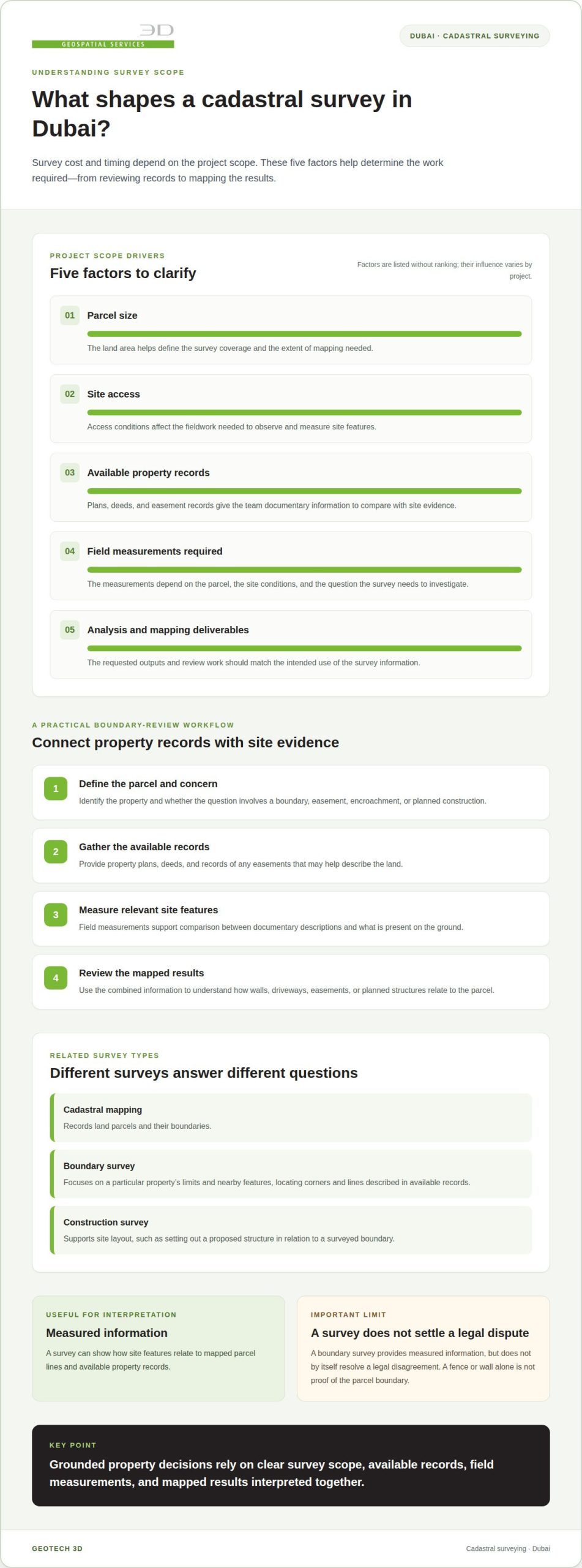
A cadastral survey connects parcel records with measured features on the ground. In Dubai, this helps owners and project teams assess boundaries, access rights, and possible encroachments before decisions about property or construction.
Boundary Disputes and Ownership Rights
A boundary survey locates property corners and lines described in the available property records. Surveyors review documents and plans, take field measurements, and analyse the combined information. The results can show how a wall, driveway, or other feature relates to the mapped parcel boundary. Easements can also be shown in relation to the land. A survey provides measured information, but does not by itself resolve a legal disagreement.
Cadastral, boundary, and construction surveys answer related but distinct questions. Cadastral mapping records land parcels and their boundaries. A boundary survey focuses on a particular property’s limits and nearby features. A construction survey supports site layout, such as setting out a proposed structure in relation to the surveyed boundary. For example, a developer can compare a planned building footprint with parcel lines before work begins.
Land Parcel Mapping and Boundary Plotting
Land parcel mapping represents each parcel as a defined area, with plotted boundaries, corners, and dimensions. The map can show how a property sits beside neighbouring plots, roads, or access corridors. Compare the mapped lines with the available property records rather than treating a fence as proof of the boundary. A fence, wall, or visible track may not align with the parcel limits shown in those records.
For a boundary concern, begin by gathering the deed, available plans, and records of any easements. Arrange the survey by defining the parcel and the issue to investigate, supplying the records, conducting field measurements, and reviewing the mapped results. These steps help the survey team compare documentary descriptions with site evidence and identify where a closer review is needed.
How much do cadastral surveying services cost in Dubai? The price depends on the project scope. Factors include parcel size, site access, available records, fieldwork, and the required mapping deliverables.
How long does a cadastral survey take in Dubai? Timing depends on site access, the clarity of available records, the field measurements required, and the analysis involved. An accessible plot with clear documentation calls for a different workflow from a site with uncertain boundaries or multiple easements.
To prepare, identify the parcel and purpose, gather available property plans and records, and specify whether the issue involves a boundary, easement, encroachment, or planned construction. The survey scope can then match the question. For cadastral surveying services in Dubai, the key is to connect records, field measurements, and clear mapping so property decisions are grounded in information about the land.
Drone mapping for cadastral projects
Drone mapping adds an aerial view to cadastral work in Dubai. It can capture site features across a broad area, helping teams understand the parcel’s context alongside ground measurements. Aerial imagery provides coverage and visual detail, but does not replace the information needed to establish a boundary. The survey purpose should guide the method.
For example, a developer assessing a large undeveloped plot may need an overview of access routes, visible structures, and terrain features. Drone imagery can help organize these observations into a mapped site record. Field measurements and documented parcel information remain important when interpreting property limits. Together, the aerial view and ground information connect broad coverage with specific locations on the site.
A practical drone mapping workflow starts with a clear project question. The survey team defines the area, required outputs, and how the work relates to available parcel records. It then plans image capture, processes the imagery, and reviews the resulting map against field information. Each step should serve the intended use, such as early site planning or recording visible features.
- Define the purpose: identify whether the map supports site context, planning, or boundary review.
- Set the coverage: outline the parcel and nearby features relevant to the project.
- Capture and process: collect aerial imagery, then produce mapped information for review.
- Compare evidence: relate visible features to parcel records and ground measurements.
Comparing aerial images with other information matters. Images show where a wall or track appears, but appearance alone does not establish ownership. For instance, an image may show a driveway crossing an apparent parcel edge. The survey team can flag the location for comparison with records and field observations, helping project teams identify questions that need closer examination.
Drone mapping is most useful when aerial coverage adds information that ground observations alone may not show efficiently. Broad development plots, dense site features, and areas that are difficult to view can benefit from an overview. Cadastral decisions still depend on the survey scope, parcel documentation, and appropriate measurements. Treat a drone image as one data layer, not a standalone boundary determination.
Before commissioning a Dubai mapping project, prepare the parcel details, intended use, and known site constraints. Clarify whether the output needs to support planning, a boundary review, or general site understanding. These details shape flight coverage, processing, and the field checks required. A geospatial survey approach can help align aerial mapping with the project’s wider measurement needs.
Surveying for property development and regulatory approval
Development surveys connect plot information with design and construction decisions. In Dubai, the survey scope should match the project stage and the intended use of the information.
Authorities for Surveys and Land Boundaries
Dubai Law No. (6) of 2017 establishes definitions for survey activities in Dubai. For official land survey reports, only approved survey engineering companies can submit them, as stated for 2025. The approval pathway matters because a measured plan for internal design may not meet the requirements for a formal submission. Identify the report’s intended use at the outset.
Building-permission submissions may require survey information suited to the project and its approval process. A developer should align the survey deliverable with the relevant submission and project stage. For example, a plot plan used during early design serves a different purpose from a survey submitted with a building-permission application.
Surveyor Qualifications and Approvals
A licensed professional land surveyor is legally authorized and qualified to conduct a boundary survey. For Dubai submissions, the survey company also needs approval to submit official land survey reports. These are distinct considerations: professional authorization relates to the surveyor, while company approval relates to official report submission. Confirm both roles when defining responsibility for a boundary deliverable.
During development, survey information can support site layout and coordination with utility lines. Before construction, teams use site measurements to relate proposed works to the plot and existing features. An as-built survey records completed construction for comparison with the approved plan. In the UAE, an as-built survey is often required before occupancy or handover.
Documents for a Survey Request
What documents are required to request a cadastral survey in Dubai? Prepare the title or deed information, available parcel plans, site location, and a clear description of the survey purpose. These records help define the parcel and the required deliverable; submission requirements depend on the approval process and project stage.
For a practical request, organize records before defining the scope:
- Provide the property title or deed details and available parcel plan.
- Identify the site location and the area requiring measurement.
- State whether the survey supports design, building permission, boundary review, or handover.
- Include relevant approved drawings when requesting an as-built comparison.
These records help distinguish a boundary survey from a topographic survey or construction check. For example, an application for building permission may require a municipality-approved topographic or cadastral survey. A handover review instead compares completed works with the approved plan through as-built information.
Set the purpose, gather the property records, and define the intended submission before commissioning fieldwork. This sequence helps ensure the survey scope produces information suited to the next development decision.
Which authorities regulate cadastral surveys and land boundaries in Dubai?
For a Dubai land question, identify the decision-maker by the record or action involved. A boundary concern, development application, and ownership-document issue may follow different administrative routes. Start by naming the parcel, the decision needed, and the document that must support it. This separates administrative requirements from the technical work of measuring or mapping a site.
Frame the enquiry around the intended outcome. If a project team needs information for design coordination, describe the design decision and the site data required. If the issue concerns a recorded parcel description, identify the relevant ownership document and the discrepancy under review. For a planned submission, name the application and receiving office. These details help clarify the process without assuming one authority handles every matter.
A useful preparation sequence is:
- Record the plot identifier and the document or plan being reviewed.
- Describe the issue, such as a boundary discrepancy or a development submission.
- Identify the decision that depends on the information.
- Ask which format and supporting records the receiving office requires.
- Keep the response with the project file and survey scope.
For example, a developer comparing a plot plan with a design should state whether the goal is design coordination or an official application. An owner questioning a parcel description should identify the document and the specific line or measurement in question. Clear examples make the enquiry more precise and reduce the risk of preparing information for the wrong administrative purpose.
Keep technical and administrative responsibilities distinct. A survey team collects and interprets spatial information; the relevant authority or receiving office determines how that information fits its process. A project manager can record the office contacted, the issue raised, the supporting material requested, and the response. This creates a traceable basis for coordinating later submissions and discussions.
Dubai projects can involve several document types across land, design, and development workflows. Avoid treating a general map as an answer to every official question. Define the specific decision, identify the document connected to it, and establish the receiving office’s requirements before fixing the survey deliverable. This keeps the enquiry focused and links land information to the project action.
What qualifications and approvals must a cadastral surveyor have in Dubai?
Assess a cadastral survey assignment by matching its scope to the decision you need to make. A useful work plan identifies the parcel, records to review, field measurements required, and analysis needed for the final output. This makes responsibilities clear before work starts and gives the project team a defined basis for reviewing the result.
Look for a clear division of technical tasks. The surveyor may need to review available property records, collect field measurements, and analyse the information together. The assignment should state which records inform the work and how site observations will be compared with them. For example, if an older plan and current site features appear inconsistent, the scope should include that comparison.
Before commissioning the work, set out the key responsibilities:
- Describe the parcel and the specific question the survey must address.
- List the available deeds, plans, and historical records for review.
- Define the field measurements needed to examine the issue on site.
- Specify how measured information and records will be analysed together.
- State the expected mapped output and its intended project use.
These points help distinguish a focused boundary investigation from a broader site survey. A project manager reviewing a proposed building location needs the survey scope to connect relevant parcel information with the planned decision. A landowner examining an uncertain line needs the work to identify the records and measurements used to assess it. Clear scope language keeps each assignment focused on its purpose.
Review the resulting documentation for a clear connection between source records, field observations, and analysis. If the report identifies an apparent discrepancy, the project team can see what information contributed to the finding and what question remains. This is useful when owners, consultants, and design teams need to discuss the same mapped information without confusing site observations with documentary evidence.
Define the purpose, input records, fieldwork, analysis, and deliverable before the survey begins. A clear assignment helps focus the work on the relevant land question and gives reviewers a consistent basis for understanding the output.
These technical details should be checked against the survey type and location rather than treated as a general credential. Professional survey standards often cite approximate vertical accuracy figures for specialized multibeam bathymetric surveys, subject to environmental and tidal conditions. Such figures relate to specific bathymetric or hydrographic work and do not, by themselves, establish a cadastral surveyor’s qualifications or approval status in Dubai.
Documentation requirements can differ by jurisdiction. Regional land survey reports often require geographic coordinates and specific CAD/GIS formats. For a Dubai cadastral assignment involving professional cadastral surveying services Dubai, define the applicable municipal approvals, licensing credentials, and deliverable requirements for the project before work starts, and make sure the agreed output addresses the parcel question.
GEOTECH 3D: topo survey
GEOTECH 3D provides topo surveys for teams that need mapped site information to support planning and development decisions. A topographic survey records visible site features and ground levels, helping designers understand how a plot relates to its existing conditions. It complements cadastral information, but does not replace a survey intended to establish legal parcel boundaries.
Turn to this service when a project needs a clearer site baseline for design coordination, grading, or construction planning. Drone Services and GIS & Surveying Services can also support mapping needs where aerial coverage or organized spatial data is relevant. The appropriate scope depends on the site and the decisions the survey must inform.
Contact GEOTECH 3D to discuss a topo survey for your Dubai project.
Plan the next survey around your project decision
Your next step is to define what the site information must help you decide. Is the priority a mapped picture of existing ground conditions, a record of visible structures, or aerial context for planning? A clear objective helps shape the survey scope and the information your project team needs.
For cadastral surveying services in Dubai, GEOTECH 3D offers topo surveys, 3D Laser Scanning, and Drone Services. These capabilities can support different site information needs, from topographic context to captured site detail and aerial mapping. The right fit depends on the project question and the outputs required by your team.
Set out the site location, intended use, and key deliverables before work begins. This gives the survey discussion a practical starting point and connects data collection to design or development planning.
A well-defined survey scope is a practical first step toward clearer decisions for your Dubai project.
Frequently Asked Questions
What Is a Land Survey?
A land survey documents measurements for a defined property or project need. Before commissioning one, decide what the deliverable must support: planning a site layout, reviewing parcel information, or recording existing conditions. This helps establish the scope and information to include. A survey provides spatial evidence for decisions; it does not replace ownership documents.
What cadastral surveying services are available in Dubai?
In Dubai, relevant services include cadastral mapping, land surveys, topographic surveys, and drone-based data collection. GEOTECH 3D’s GIS & Surveying Services include cadastral mapping, while its Drone Services support aerial data collection. For a mixed-use site, a project team might need parcel mapping for land records and aerial coverage to examine broader site context. The required outputs depend on the task and intended use.
How can I verify plot boundaries and land area using Dubai cadastral records?
Start by matching the plot identifier across your property documents and the cadastral information under review. Compare recorded dimensions and area, and note the document version or date so you do not compare different records. Then describe any mismatch precisely, such as a differing side length or parcel outline. A measured survey can investigate that specific discrepancy and provide mapped information for project review.
What is the difference between cadastral, topographic, and boundary surveys in Dubai?
The main distinction is the question each survey is designed to answer. Cadastral work supports parcel records, a boundary survey examines one property’s limits, and topographic work captures site conditions relevant to design. A project combining land-record review with site design may need more than one information layer. State the decision first, then scope the survey outputs to avoid collecting details that do not serve the project.
What risks or disputes can arise from inaccurate cadastral surveys in Dubai?
An inaccurate survey can lead teams to base drawings or site decisions on incorrect spatial information. For example, a design may need revision if later measurements place a proposed feature differently from the mapped information. Inconsistent parcel data can also complicate coordination between owners, consultants, and contractors. Keep source records and survey deliverables together so reviewers can trace which information informed the design or land decision.

A boundary line on a plan is only useful when it can be located and understood on the ground. A land survey measures and maps property limits and site features; cadastral surveying services in Dubai can also document easements and encroachments, with field measurements supporting boundary records and development planning.
Before buying land, addressing a boundary concern, or moving a project forward, it helps to understand what the survey can show. This guide explains how cadastral surveying supports decisions about property limits, access, and site conditions.
You’ll also learn where drone mapping can complement ground measurements, what information may be useful for development approval submissions, and how survey outputs can support better coordination between project teams. The aim is to make the role of each method clear, so you can understand what your project needs and how the survey information fits into the next stage.
Key Takeaways
- Use a boundary survey to understand where property lines fall and how structures, easements, or encroachments relate to them.
- Consider drone mapping for broad site coverage, while using field measurements to support cadastral detail and ground interpretation.
- Match survey information to the development stage so boundary and site data can inform planning and approval submissions.
- Understand the roles of Dubai’s surveying framework and qualified professionals before relying on a survey for legal or project decisions.
- Explore how a topo survey can provide mapped site information for planning and development coordination.
Boundary disputes, easements and encroachments
A cadastral survey connects parcel records with measured features on the ground. In Dubai, this helps owners and project teams assess boundaries, access rights, and possible encroachments before decisions about property or construction.
Boundary Disputes and Ownership Rights
A boundary survey locates property corners and lines described in the available property records. Surveyors review documents and plans, take field measurements, and analyse the combined information. The results can show how a wall, driveway, or other feature relates to the mapped parcel boundary. Easements can also be shown in relation to the land. A survey provides measured information, but does not by itself resolve a legal disagreement.
Cadastral, boundary, and construction surveys answer related but distinct questions. Cadastral mapping records land parcels and their boundaries. A boundary survey focuses on a particular property’s limits and nearby features. A construction survey supports site layout, such as setting out a proposed structure in relation to the surveyed boundary. For example, a developer can compare a planned building footprint with parcel lines before work begins.
Land Parcel Mapping and Boundary Plotting
Land parcel mapping represents each parcel as a defined area, with plotted boundaries, corners, and dimensions. The map can show how a property sits beside neighbouring plots, roads, or access corridors. Compare the mapped lines with the available property records rather than treating a fence as proof of the boundary. A fence, wall, or visible track may not align with the parcel limits shown in those records.
For a boundary concern, begin by gathering the deed, available plans, and records of any easements. Arrange the survey by defining the parcel and the issue to investigate, supplying the records, conducting field measurements, and reviewing the mapped results. These steps help the survey team compare documentary descriptions with site evidence and identify where a closer review is needed.
How much do cadastral surveying services cost in Dubai? The price depends on the project scope. Factors include parcel size, site access, available records, fieldwork, and the required mapping deliverables.
How long does a cadastral survey take in Dubai? Timing depends on site access, the clarity of available records, the field measurements required, and the analysis involved. An accessible plot with clear documentation calls for a different workflow from a site with uncertain boundaries or multiple easements.
To prepare, identify the parcel and purpose, gather available property plans and records, and specify whether the issue involves a boundary, easement, encroachment, or planned construction. The survey scope can then match the question. For cadastral surveying services in Dubai, the key is to connect records, field measurements, and clear mapping so property decisions are grounded in information about the land.
Drone mapping for cadastral projects
Drone mapping adds an aerial view to cadastral work in Dubai. It can capture site features across a broad area, helping teams understand the parcel’s context alongside ground measurements. Aerial imagery provides coverage and visual detail, but does not replace the information needed to establish a boundary. The survey purpose should guide the method.
For example, a developer assessing a large undeveloped plot may need an overview of access routes, visible structures, and terrain features. Drone imagery can help organize these observations into a mapped site record. Field measurements and documented parcel information remain important when interpreting property limits. Together, the aerial view and ground information connect broad coverage with specific locations on the site.
A practical drone mapping workflow starts with a clear project question. The survey team defines the area, required outputs, and how the work relates to available parcel records. It then plans image capture, processes the imagery, and reviews the resulting map against field information. Each step should serve the intended use, such as early site planning or recording visible features.
- Define the purpose: identify whether the map supports site context, planning, or boundary review.
- Set the coverage: outline the parcel and nearby features relevant to the project.
- Capture and process: collect aerial imagery, then produce mapped information for review.
- Compare evidence: relate visible features to parcel records and ground measurements.
Comparing aerial images with other information matters. Images show where a wall or track appears, but appearance alone does not establish ownership. For instance, an image may show a driveway crossing an apparent parcel edge. The survey team can flag the location for comparison with records and field observations, helping project teams identify questions that need closer examination.
Drone mapping is most useful when aerial coverage adds information that ground observations alone may not show efficiently. Broad development plots, dense site features, and areas that are difficult to view can benefit from an overview. Cadastral decisions still depend on the survey scope, parcel documentation, and appropriate measurements. Treat a drone image as one data layer, not a standalone boundary determination.
Before commissioning a Dubai mapping project, prepare the parcel details, intended use, and known site constraints. Clarify whether the output needs to support planning, a boundary review, or general site understanding. These details shape flight coverage, processing, and the field checks required. A geospatial survey approach can help align aerial mapping with the project’s wider measurement needs.
Surveying for property development and regulatory approval
Development surveys connect plot information with design and construction decisions. In Dubai, the survey scope should match the project stage and the intended use of the information.
Authorities for Surveys and Land Boundaries
Dubai Law No. (6) of 2017 establishes definitions for survey activities in Dubai. For official land survey reports, only approved survey engineering companies can submit them, as stated for 2025. The approval pathway matters because a measured plan for internal design may not meet the requirements for a formal submission. Identify the report’s intended use at the outset.
Building-permission submissions may require survey information suited to the project and its approval process. A developer should align the survey deliverable with the relevant submission and project stage. For example, a plot plan used during early design serves a different purpose from a survey submitted with a building-permission application.
Surveyor Qualifications and Approvals
A licensed professional land surveyor is legally authorized and qualified to conduct a boundary survey. For Dubai submissions, the survey company also needs approval to submit official land survey reports. These are distinct considerations: professional authorization relates to the surveyor, while company approval relates to official report submission. Confirm both roles when defining responsibility for a boundary deliverable.
During development, survey information can support site layout and coordination with utility lines. Before construction, teams use site measurements to relate proposed works to the plot and existing features. An as-built survey records completed construction for comparison with the approved plan. In the UAE, an as-built survey is often required before occupancy or handover.
Documents for a Survey Request
What documents are required to request a cadastral survey in Dubai? Prepare the title or deed information, available parcel plans, site location, and a clear description of the survey purpose. These records help define the parcel and the required deliverable; submission requirements depend on the approval process and project stage.
For a practical request, organize records before defining the scope:
- Provide the property title or deed details and available parcel plan.
- Identify the site location and the area requiring measurement.
- State whether the survey supports design, building permission, boundary review, or handover.
- Include relevant approved drawings when requesting an as-built comparison.
These records help distinguish a boundary survey from a topographic survey or construction check. For example, an application for building permission may require a municipality-approved topographic or cadastral survey. A handover review instead compares completed works with the approved plan through as-built information.
Set the purpose, gather the property records, and define the intended submission before commissioning fieldwork. This sequence helps ensure the survey scope produces information suited to the next development decision.
Which authorities regulate cadastral surveys and land boundaries in Dubai?
For a Dubai land question, identify the decision-maker by the record or action involved. A boundary concern, development application, and ownership-document issue may follow different administrative routes. Start by naming the parcel, the decision needed, and the document that must support it. This separates administrative requirements from the technical work of measuring or mapping a site.
Frame the enquiry around the intended outcome. If a project team needs information for design coordination, describe the design decision and the site data required. If the issue concerns a recorded parcel description, identify the relevant ownership document and the discrepancy under review. For a planned submission, name the application and receiving office. These details help clarify the process without assuming one authority handles every matter.
A useful preparation sequence is:
- Record the plot identifier and the document or plan being reviewed.
- Describe the issue, such as a boundary discrepancy or a development submission.
- Identify the decision that depends on the information.
- Ask which format and supporting records the receiving office requires.
- Keep the response with the project file and survey scope.
For example, a developer comparing a plot plan with a design should state whether the goal is design coordination or an official application. An owner questioning a parcel description should identify the document and the specific line or measurement in question. Clear examples make the enquiry more precise and reduce the risk of preparing information for the wrong administrative purpose.
Keep technical and administrative responsibilities distinct. A survey team collects and interprets spatial information; the relevant authority or receiving office determines how that information fits its process. A project manager can record the office contacted, the issue raised, the supporting material requested, and the response. This creates a traceable basis for coordinating later submissions and discussions.
Dubai projects can involve several document types across land, design, and development workflows. Avoid treating a general map as an answer to every official question. Define the specific decision, identify the document connected to it, and establish the receiving office’s requirements before fixing the survey deliverable. This keeps the enquiry focused and links land information to the project action.
What qualifications and approvals must a cadastral surveyor have in Dubai?
Assess a cadastral survey assignment by matching its scope to the decision you need to make. A useful work plan identifies the parcel, records to review, field measurements required, and analysis needed for the final output. This makes responsibilities clear before work starts and gives the project team a defined basis for reviewing the result.
Look for a clear division of technical tasks. The surveyor may need to review available property records, collect field measurements, and analyse the information together. The assignment should state which records inform the work and how site observations will be compared with them. For example, if an older plan and current site features appear inconsistent, the scope should include that comparison.
Before commissioning the work, set out the key responsibilities:
- Describe the parcel and the specific question the survey must address.
- List the available deeds, plans, and historical records for review.
- Define the field measurements needed to examine the issue on site.
- Specify how measured information and records will be analysed together.
- State the expected mapped output and its intended project use.
These points help distinguish a focused boundary investigation from a broader site survey. A project manager reviewing a proposed building location needs the survey scope to connect relevant parcel information with the planned decision. A landowner examining an uncertain line needs the work to identify the records and measurements used to assess it. Clear scope language keeps each assignment focused on its purpose.
Review the resulting documentation for a clear connection between source records, field observations, and analysis. If the report identifies an apparent discrepancy, the project team can see what information contributed to the finding and what question remains. This is useful when owners, consultants, and design teams need to discuss the same mapped information without confusing site observations with documentary evidence.
Define the purpose, input records, fieldwork, analysis, and deliverable before the survey begins. A clear assignment helps focus the work on the relevant land question and gives reviewers a consistent basis for understanding the output.
These technical details should be checked against the survey type and location rather than treated as a general credential. Professional survey standards often cite approximate vertical accuracy figures for specialized multibeam bathymetric surveys, subject to environmental and tidal conditions. Such figures relate to specific bathymetric or hydrographic work and do not, by themselves, establish a cadastral surveyor’s qualifications or approval status in Dubai.
Documentation requirements can differ by jurisdiction. Regional land survey reports often require geographic coordinates and specific CAD/GIS formats. For a Dubai cadastral assignment involving professional cadastral surveying services Dubai, define the applicable municipal approvals, licensing credentials, and deliverable requirements for the project before work starts, and make sure the agreed output addresses the parcel question.
GEOTECH 3D: topo survey
GEOTECH 3D provides topo surveys for teams that need mapped site information to support planning and development decisions. A topographic survey records visible site features and ground levels, helping designers understand how a plot relates to its existing conditions. It complements cadastral information, but does not replace a survey intended to establish legal parcel boundaries.
Turn to this service when a project needs a clearer site baseline for design coordination, grading, or construction planning. Drone Services and GIS & Surveying Services can also support mapping needs where aerial coverage or organized spatial data is relevant. The appropriate scope depends on the site and the decisions the survey must inform.
Contact GEOTECH 3D to discuss a topo survey for your Dubai project.
Plan the next survey around your project decision
Your next step is to define what the site information must help you decide. Is the priority a mapped picture of existing ground conditions, a record of visible structures, or aerial context for planning? A clear objective helps shape the survey scope and the information your project team needs.
For cadastral surveying services in Dubai, GEOTECH 3D offers topo surveys, 3D Laser Scanning, and Drone Services. These capabilities can support different site information needs, from topographic context to captured site detail and aerial mapping. The right fit depends on the project question and the outputs required by your team.
Set out the site location, intended use, and key deliverables before work begins. This gives the survey discussion a practical starting point and connects data collection to design or development planning.
A well-defined survey scope is a practical first step toward clearer decisions for your Dubai project.
Frequently Asked Questions
What Is a Land Survey?
A land survey documents measurements for a defined property or project need. Before commissioning one, decide what the deliverable must support: planning a site layout, reviewing parcel information, or recording existing conditions. This helps establish the scope and information to include. A survey provides spatial evidence for decisions; it does not replace ownership documents.
What cadastral surveying services are available in Dubai?
In Dubai, relevant services include cadastral mapping, land surveys, topographic surveys, and drone-based data collection. GEOTECH 3D’s GIS & Surveying Services include cadastral mapping, while its Drone Services support aerial data collection. For a mixed-use site, a project team might need parcel mapping for land records and aerial coverage to examine broader site context. The required outputs depend on the task and intended use.
How can I verify plot boundaries and land area using Dubai cadastral records?
Start by matching the plot identifier across your property documents and the cadastral information under review. Compare recorded dimensions and area, and note the document version or date so you do not compare different records. Then describe any mismatch precisely, such as a differing side length or parcel outline. A measured survey can investigate that specific discrepancy and provide mapped information for project review.
What is the difference between cadastral, topographic, and boundary surveys in Dubai?
The main distinction is the question each survey is designed to answer. Cadastral work supports parcel records, a boundary survey examines one property’s limits, and topographic work captures site conditions relevant to design. A project combining land-record review with site design may need more than one information layer. State the decision first, then scope the survey outputs to avoid collecting details that do not serve the project.
What risks or disputes can arise from inaccurate cadastral surveys in Dubai?
An inaccurate survey can lead teams to base drawings or site decisions on incorrect spatial information. For example, a design may need revision if later measurements place a proposed feature differently from the mapped information. Inconsistent parcel data can also complicate coordination between owners, consultants, and contractors. Keep source records and survey deliverables together so reviewers can trace which information informed the design or land decision.
Search Now
Error: Contact form not found.