

Our Services
How Digital Twins Connect Smart City Systems
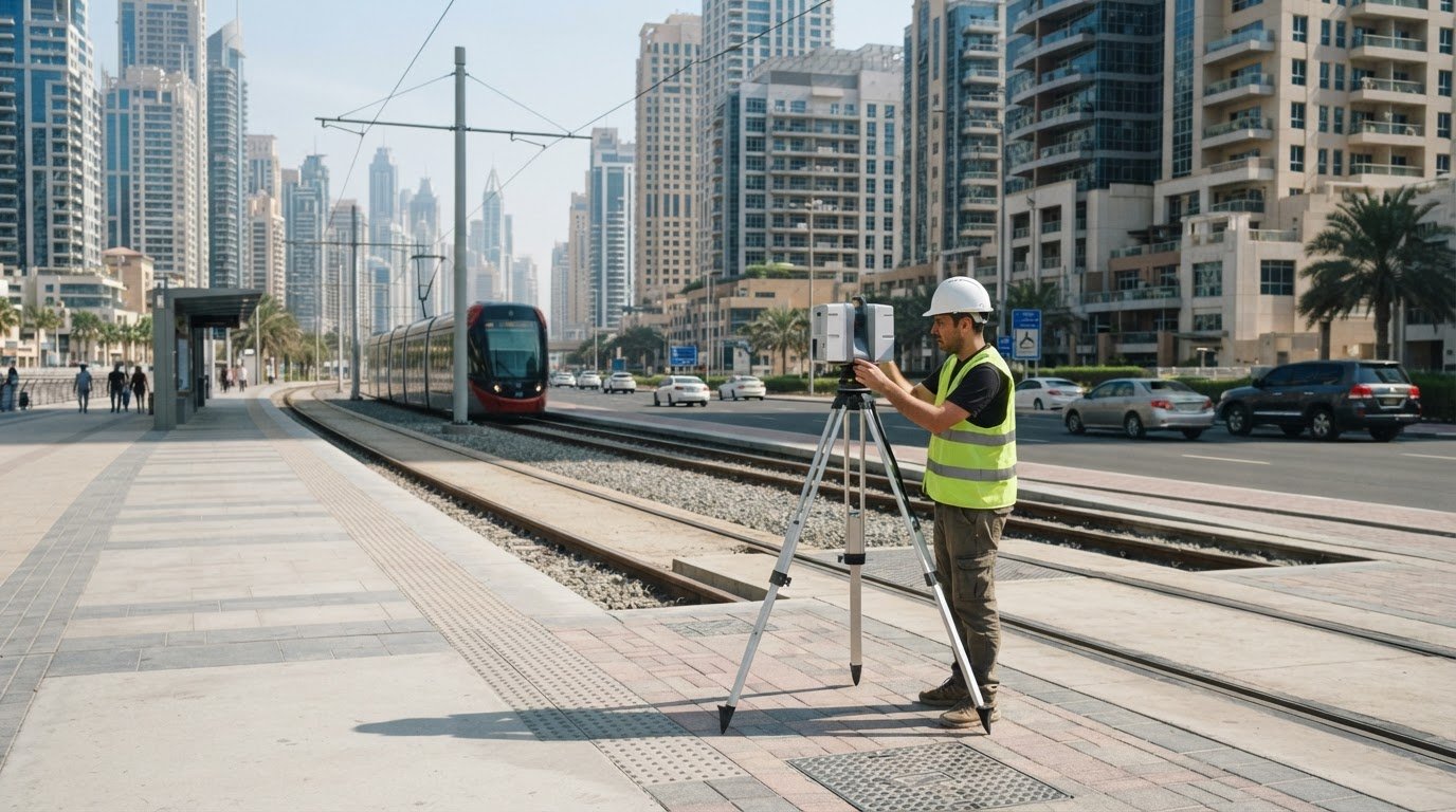
A city’s infrastructure works as a network, but its data is often scattered across separate systems. To understand what a digital twin for smart cities is, consider how a digital model connects urban places and infrastructure with changing data. This can help teams monitor conditions, explore scenarios, and make better-informed decisions about services, safety, and the environment.
City leaders know that traffic, utilities, buildings, and public spaces affect one another. A digital twin brings these relationships into view instead of treating each system as an isolated problem. Its value depends on reliable spatial information, useful data connections, and clear processes for keeping the model current.
This article explains why cities use digital twins and how data, sensors, analytics, and spatial networks work together. It also explores potential applications for safety, environmental management, and communities, with practical context for Dubai and the wider UAE. You’ll learn where a digital twin can inform urban decisions and what foundations help make it useful.
Key Takeaways
- Understand how a city-scale digital twin links infrastructure, spatial information, and changing data to support coordinated decisions.
- Learn why clear design principles, reliable updates, and data governance matter when building an urban digital twin.
- See how connected sensors and analytics can help city teams interpret networks such as transport, utilities, and energy systems.
- Explore how digital twins can inform safety planning and environmental management while making trade-offs more visible to communities.
- Identify how accurate survey and geospatial data can provide a practical foundation for digital twin work in Dubai and the UAE.
Why are Digital Twins essential for Smart Cities?
A digital twin gives city teams a connected, data-informed view of urban systems and how they interact. It can help planners move beyond isolated dashboards to compare conditions, identify dependencies, and assess potential decisions.
According to the United Nations, 55% of the world’s population lives in urban areas today, a proportion expected to increase to 68% by 2050. As cities grow, an intelligent operating layer can help coordinate transport, utilities, buildings, and public services using shared spatial context.
IoT sensors can provide changing information about traffic, energy use, water distribution, and environmental conditions. AI and analytics can help interpret those inputs, identify patterns, and test scenarios. The twin’s value depends on data quality, suitable update frequency, and clear responsibility for maintaining connected datasets.
For urban infrastructure, governance matters as much as technology. City authorities need to define who can access sensitive information, where data is managed, and how updates are approved. In the UAE, project teams should map applicable data-protection, cybersecurity, and infrastructure requirements to the systems and information involved. Standards should also clarify data formats, quality controls, access, and responsibility for updates.
Digital Twins, 3D Models, and GIS
A 3D city model represents urban features visually, while GIS organizes and analyzes information tied to locations; a digital twin connects spatial representations with operational data and ongoing analysis. The distinction matters because a visually detailed model alone doesn’t show changing conditions or support the same monitoring and scenario testing. For a Dubai transport corridor, for example, mapped roads can be connected with traffic signals and current congestion data.
This connection can help teams understand how a change affects adjoining systems. It also makes data alignment essential: asset locations, network relationships, and sensor observations need a consistent spatial reference for meaningful analysis.
Real-World City Examples
Real-world examples show how digital twins can address different urban priorities. Maracaibo used a twin incorporating power usage, mobility patterns, and zoning regulations to assess development scenarios against public policy objectives. This allows planners to compare a proposed intervention across multiple city systems instead of evaluating land use or transport in isolation.
Road safety provides another application. The Horizon Europe Prosafe-Twin project brings together 17 organisations to anticipate road risks and plans pilots across Europe. AI can help identify patterns in road and mobility data, while a hybrid twin can combine digital analysis with knowledge of real-world conditions. City teams can use those insights to examine risk locations and consider targeted interventions.
For city decision-makers, the practical test is whether connected data helps answer a defined operational question. A twin can support monitoring and scenario assessment, but it still needs dependable inputs, sound governance, and a clear link between analysis and decisions.
Urban digital twin principles and design
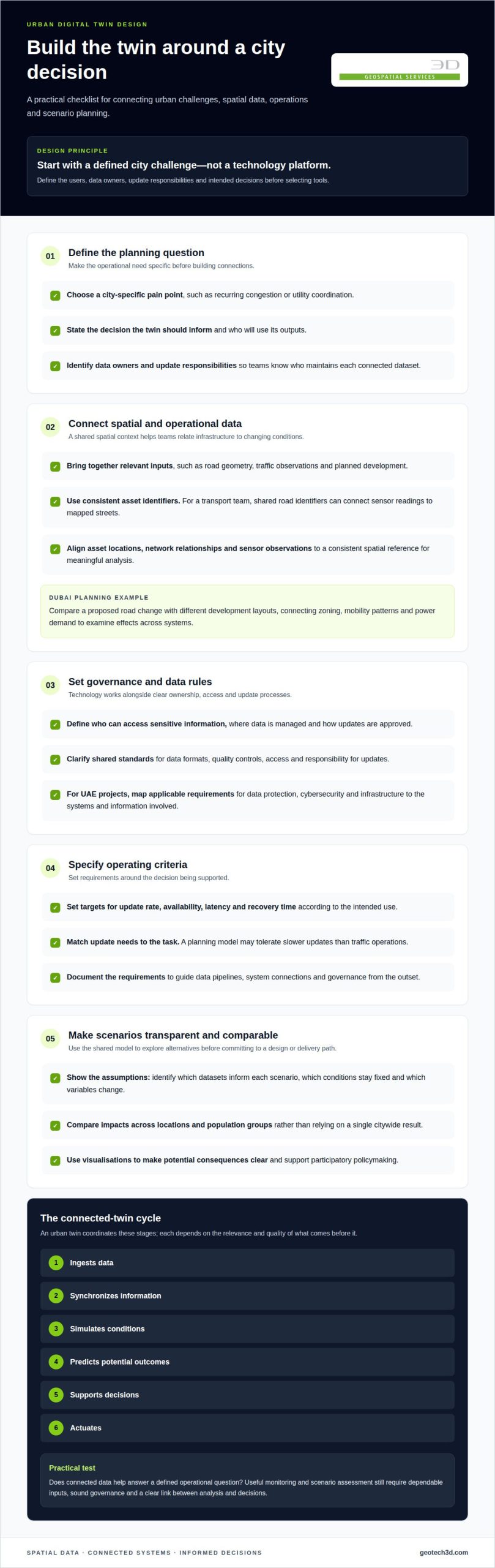
Urban digital twin design starts with a defined city challenge, not a technology platform. Teams then connect the spatial, operational, and governance elements needed to examine it.
A useful design turns an urban planning question into data, models, and decisions. For a transport project, this could mean linking road geometry, traffic observations, and planned development.
Principles for Urban Twin Design
An urban twin is a coordinated system that ingests, synchronizes, simulates, predicts, decides, and actuates. Each stage depends on the quality and relevance of the information that comes before it.
Start with a city-specific pain point, such as recurring congestion or utility coordination. Define the users, data owners, update responsibilities, and intended decisions before selecting tools. A transport team, for example, needs consistent road identifiers to connect sensor readings to mapped streets. Without shared definitions, separate datasets may describe the same asset differently.
Design also requires measurable operating criteria. Teams can set targets for update rate, availability, latency, and recovery time based on the decision being supported. A planning model may tolerate slower updates than traffic operations. Documenting these requirements helps technical teams prioritize data pipelines, system connections, and governance from the outset.
Urban Planning Simulations
What-if simulations compare alternative interventions using a shared model of urban conditions. They help planners examine potential consequences before committing a project to a design or delivery path.
For example, a Dubai planning team could compare a proposed road change with different development layouts. The model could combine zoning, mobility patterns, and power demand to show how each scenario affects connected systems. Maracaibo has used these data types to assess urban development scenarios against public policy objectives.
Useful simulations make their assumptions visible. Planners should identify which datasets inform each scenario, which conditions remain fixed, and which variables change. They can then compare impacts across locations and population groups instead of relying on a single citywide result. Visualisations can also support participatory policymaking by showing residents the potential consequences of different interventions.
Infrastructure in Urban Planning
Infrastructure provides an urban twin’s physical framework, connecting streets, buildings, utilities, and public spaces. Mapping these relationships helps planners assess how a change in one asset may affect adjoining networks.
For a new development, a coordinated view can bring site boundaries, access routes, and utility corridors into planning discussions. Sensors add operational observations, while AI can help identify patterns in transport data and support scenario analysis. The model should distinguish measured conditions from assumptions so teams understand the basis for each comparison.
These design principles apply to projects across the UAE, where decisions about transport and development can involve intersecting systems. Teams establishing a spatial foundation for a twin can explore urban digital twin and geospatial capabilities as part of their planning.
AI, machine learning, big data and spatial networks
Urban digital twins connect location-based information with computing systems that process changing city data. Their applications depend on how sensor inputs are aligned, analyzed, and made available for monitoring.
Location Data and Resilient Infrastructure
Location data connects digital records to specific streets, assets, and service areas, making infrastructure information meaningful in context. For a road-network application, a sensor reading is more useful when linked to the correct road segment and timestamp. Consistent identifiers help analysts compare observations from different systems without confusing nearby assets.
Resilient digital infrastructure relies on dependable data flows and clear procedures for handling delayed or incomplete inputs. Before using an observation in an operational decision, a city team can identify its source, location, and update time. This helps distinguish a live reading from an older record, particularly when monitoring connected transport or utility networks.
Cloud architecture can consolidate sensor streams for applications that need broader computing capacity. One described cloud architecture ingests more than 25 different types of sensors and currently manages 40,000 devices. Those figures illustrate the integration demands of a large data environment, not a universal requirement for every city. A smaller deployment can begin with the sensors tied to a defined operational need.
IoT and Big-Data Analytics
IoT devices collect observations, big-data analytics organize and examine them, and AI can identify patterns across the resulting datasets. For example, traffic sensors can provide flow observations that an analytical model compares across locations and times. Together, these tools help city teams move beyond displaying readings to investigating recurring congestion patterns.
Machine learning can support predictive applications by finding relationships in historical and incoming data. A transport team could compare sensor observations with mapped road conditions to identify recurring congestion patterns. The model’s usefulness depends on relevant inputs, consistent location references, and evaluation against real operating conditions. Analysts should also account for missing or biased data when interpreting predictions.
Edge and cloud computing serve different roles in this architecture. Edge processing handles data close to its source, while cloud systems can combine information across wider networks. For traffic monitoring, local processing might flag a changing condition while broader analytics compare it with citywide patterns. The design should match processing needs to the decision being supported.
For Dubai and other urban settings in the UAE, integration choices determine whether data can move between systems and support coordinated analysis. Teams can define shared location references, data ownership, update processes, and access controls before connecting additional IoT sources. This foundation helps make AI and analytics insights traceable to their inputs, rather than isolated outputs without operational context.
Public safety and environmental management
Digital twins can bring safety, transport, energy, and environmental information into operational planning. City teams can use this connected view to assess conditions, compare scenarios, and prioritize action.
For public safety, a twin can help teams examine how roads, buildings, and essential services relate during an incident. A road closure, for example, can be considered alongside nearby routes and access to critical facilities. This supports coordinated planning by making dependencies easier to see. A twin provides analysis and situational context; it does not replace emergency procedures or decisions by responsible personnel.
Traffic operations can use mapped congestion, road closures, and traffic-light status to support route planning. If an obstruction affects a major corridor, a digital twin can show connected routes and help assess alternative flows. Advanced analytics can also identify recurring congestion patterns for further review. Planners can compare the likely effects of proposed changes across the network before applying them to real traffic operations.
Energy management can benefit from a twin that links demand information with infrastructure and generation assets. Forecasting can help operators examine how anticipated demand may affect grid operations and where capacity planning needs attention. A city could also model how integrating solar or wind generation changes energy-system performance. These scenarios inform planning discussions, while operational teams remain responsible for grid decisions.
Environmental management can use spatially organized observations to examine conditions across districts and infrastructure. For example, a city can compare environmental readings near busy roads with information about nearby land uses. The twin can help teams identify patterns, locate areas for further investigation, and assess proposed interventions. The analysis depends on suitable data coverage and a clear link between each observation and its location.
In Dubai, planning scenarios can consider heat, energy demand, transport activity, and the built environment together. A team evaluating a road project, for instance, can examine traffic changes alongside potential effects on nearby urban areas. This joined-up view frames decisions around multiple objectives rather than one isolated metric. It also makes assumptions and trade-offs clearer to planners and stakeholders.
A practical process is to define the operational question, connect relevant data, review the model’s output, and record the resulting decision. For a traffic intervention, teams might assess congestion, compare route options, and document why they selected a particular response. For energy planning, they can test demand and generation scenarios. This disciplined approach makes analysis more traceable across safety and environmental operations.
Economic and social implications
A city digital twin requires investment in connected data, computing, implementation, and ongoing operations. Its economic value depends on whether city teams use its outputs to improve decisions, coordinate projects, or manage assets more effectively.
There is no single fixed cost for building and maintaining a city digital twin. Investment depends on geographic coverage, data capture, sensor integration, software architecture, cybersecurity, staffing, and update frequency. A district-level planning model has different requirements from a citywide system connected to transport and utility operations. Maintenance also involves keeping datasets current and assigning people to manage system changes.
Economic evaluation should connect implementation costs to a defined public objective. For example, a transport authority can assess whether connected traffic information supports better corridor planning. An asset team can examine whether condition monitoring informs maintenance priorities. These are evaluation questions, not guaranteed savings. Teams should define baseline conditions and indicators before deployment, then track whether the twin supports the intended decisions.
Implementation also affects city capability. Digital twin programmes need coordination among data scientists, software engineers, and domain experts who understand planning, transport, or utilities. A city can identify these roles early, establish responsibility for data updates, and plan knowledge transfer across departments. A SmartCitiesWorld report draws on a survey of 100 senior practitioners about city digital investments, results, and obstacles, reflecting the importance of implementation as well as technology.
Social outcomes depend on whose needs are represented in the data and scenarios. For a road redesign, planners can compare effects across neighbourhoods and population groups instead of measuring only overall traffic flow. Visualisations can help residents understand proposed interventions and discuss trade-offs. Clear explanations of assumptions make public engagement more meaningful and help decision-makers identify gaps in the analysis.
Connected systems also bring governance responsibilities. City teams should define access roles, data ownership, update processes, and how model outputs inform public decisions. For example, a planning department could record which datasets informed a land-use scenario and when they were updated. This traceability helps staff interpret results and explain their basis to stakeholders.
For Dubai and the wider UAE, implementation should match the twin’s scope to a specific urban priority. Start by identifying the decision it needs to support, the departments involved, and the data required. Then assess operational capacity, public value, and how results will be evaluated. This approach links investment choices to practical outcomes instead of treating a digital platform as an end in itself.
GEOTECH 3D: topo survey
GEOTECH 3D provides topo surveys that help establish a mapped view of site conditions for planning and digital twin work. A reliable spatial baseline can help project teams relate proposed infrastructure to existing terrain and site features. This is useful when development, access, or utilities need to be considered within their surrounding context.
For projects that need more detailed spatial information, 3D Laser Scanning, Drone Services, and GIS & Surveying Services can support different data-capture and mapping requirements. The right approach depends on the site, the assets being represented, and how the resulting information will inform planning or operations.
For a Dubai or UAE project, contact GEOTECH 3D to discuss a topo survey, or visit geotech3d.com.
Turn Urban Data Into a Clear Next Step
Understanding what a digital twin for smart cities can support is a starting point, not the end goal. Next, identify a specific decision that better-connected spatial and operational information could inform. For a Dubai project, this might mean clarifying how a development, asset, or district should be represented and which teams will use the resulting information.
Then define the project boundary, the data needed, and how updates will be managed. A focused scope gives stakeholders a practical basis for assessing the model’s purpose and role in planning or operations. It also connects the digital twin approach to decisions that matter to your organisation.
GEOTECH 3D’s GEOVERSE Digital Twin is a relevant next step for organisations exploring digital twin work. Discuss your project objectives and spatial data requirements to consider an approach suited to your needs.
A well-defined next step can turn complex urban technology into a purposeful project.
Frequently Asked Questions
What is a digital twin for a smart city?
A smart city digital twin is a digital representation of urban assets and processes, connected to information about their real-world condition. Its scope can range from a building or transport corridor to a wider urban area. For an asset owner, its practical value depends on the decisions it supports, such as coordinating planned works or understanding how a facility relates to nearby infrastructure.
How do smart city digital twins work, and what technologies do they use?
Digital twins work by bringing spatial models and operational information together, then using software to analyze or present them. Technologies can include GIS, IoT sensors, cloud or edge computing, and AI or machine-learning tools. For example, a transport team can align mapped road assets with incoming operational data. Data validation and clear update processes help teams judge whether information suits a particular decision.
What data sources are used to build and update a city digital twin?
Common inputs include GIS layers, asset registers, building information models, survey data, sensor readings, and maintenance records. A transport-focused twin may also use road layouts, traffic observations, and signal information. Each dataset should have a known location reference, owner, and update process. For instance, a maintenance record linked to an asset identifier can help staff interpret its history alongside mapped site information.
What are common applications and benefits of digital twins in cities?
Common applications include infrastructure planning, asset management, transport analysis, utility coordination, and environmental monitoring. A city team can use a shared model to examine how planned roadworks relate to nearby assets and ongoing projects. This makes dependencies easier to assess and can support better coordination between departments. The benefit comes from applying connected information to a clear operational need, not simply creating a detailed visual model.
What steps are involved in planning and implementing a city digital twin?
Start by assigning an operational owner and defining the decision the twin should support. Next, identify relevant datasets and their custodians, and decide how to assess data quality. Set acceptance criteria for the model, test it against known site or asset conditions, and document how users should interpret its outputs. A focused pilot can reveal integration and workflow issues before the approach expands to more departments or areas.
What privacy, cybersecurity, data governance, and ethical risks do city digital twins pose?
Risks include unauthorized access, excessive collection of personal information, biased datasets, and decisions based on outdated or incomplete inputs. Detailed location traces can reveal sensitive patterns, so teams should limit access and collection to defined purposes. Governance can also specify retention, update ownership, and audit records. Human review matters when model outputs influence services or planning, particularly where data gaps could affect communities unevenly.
What standards and regulations apply to smart city digital twins?
City authorities should map applicable data-protection, cybersecurity, and infrastructure requirements to the systems and information involved. Standards should clarify data formats, quality controls, access, and responsibility for updates.
A city’s infrastructure works as a network, but its data is often scattered across separate systems. To understand what a digital twin for smart cities is, consider how a digital model connects urban places and infrastructure with changing data. This can help teams monitor conditions, explore scenarios, and make better-informed decisions about services, safety, and the environment.
City leaders know that traffic, utilities, buildings, and public spaces affect one another. A digital twin brings these relationships into view instead of treating each system as an isolated problem. Its value depends on reliable spatial information, useful data connections, and clear processes for keeping the model current.
This article explains why cities use digital twins and how data, sensors, analytics, and spatial networks work together. It also explores potential applications for safety, environmental management, and communities, with practical context for Dubai and the wider UAE. You’ll learn where a digital twin can inform urban decisions and what foundations help make it useful.
Key Takeaways
- Understand how a city-scale digital twin links infrastructure, spatial information, and changing data to support coordinated decisions.
- Learn why clear design principles, reliable updates, and data governance matter when building an urban digital twin.
- See how connected sensors and analytics can help city teams interpret networks such as transport, utilities, and energy systems.
- Explore how digital twins can inform safety planning and environmental management while making trade-offs more visible to communities.
- Identify how accurate survey and geospatial data can provide a practical foundation for digital twin work in Dubai and the UAE.
Why are Digital Twins essential for Smart Cities?
A digital twin gives city teams a connected, data-informed view of urban systems and how they interact. It can help planners move beyond isolated dashboards to compare conditions, identify dependencies, and assess potential decisions.
According to the United Nations, 55% of the world’s population lives in urban areas today, a proportion expected to increase to 68% by 2050. As cities grow, an intelligent operating layer can help coordinate transport, utilities, buildings, and public services using shared spatial context.
IoT sensors can provide changing information about traffic, energy use, water distribution, and environmental conditions. AI and analytics can help interpret those inputs, identify patterns, and test scenarios. The twin’s value depends on data quality, suitable update frequency, and clear responsibility for maintaining connected datasets.
For urban infrastructure, governance matters as much as technology. City authorities need to define who can access sensitive information, where data is managed, and how updates are approved. In the UAE, project teams should map applicable data-protection, cybersecurity, and infrastructure requirements to the systems and information involved. Standards should also clarify data formats, quality controls, access, and responsibility for updates.
Digital Twins, 3D Models, and GIS
A 3D city model represents urban features visually, while GIS organizes and analyzes information tied to locations; a digital twin connects spatial representations with operational data and ongoing analysis. The distinction matters because a visually detailed model alone doesn’t show changing conditions or support the same monitoring and scenario testing. For a Dubai transport corridor, for example, mapped roads can be connected with traffic signals and current congestion data.
This connection can help teams understand how a change affects adjoining systems. It also makes data alignment essential: asset locations, network relationships, and sensor observations need a consistent spatial reference for meaningful analysis.
Real-World City Examples
Real-world examples show how digital twins can address different urban priorities. Maracaibo used a twin incorporating power usage, mobility patterns, and zoning regulations to assess development scenarios against public policy objectives. This allows planners to compare a proposed intervention across multiple city systems instead of evaluating land use or transport in isolation.
Road safety provides another application. The Horizon Europe Prosafe-Twin project brings together 17 organisations to anticipate road risks and plans pilots across Europe. AI can help identify patterns in road and mobility data, while a hybrid twin can combine digital analysis with knowledge of real-world conditions. City teams can use those insights to examine risk locations and consider targeted interventions.
For city decision-makers, the practical test is whether connected data helps answer a defined operational question. A twin can support monitoring and scenario assessment, but it still needs dependable inputs, sound governance, and a clear link between analysis and decisions.
Urban digital twin principles and design
Urban digital twin design starts with a defined city challenge, not a technology platform. Teams then connect the spatial, operational, and governance elements needed to examine it.
A useful design turns an urban planning question into data, models, and decisions. For a transport project, this could mean linking road geometry, traffic observations, and planned development.
Principles for Urban Twin Design
An urban twin is a coordinated system that ingests, synchronizes, simulates, predicts, decides, and actuates. Each stage depends on the quality and relevance of the information that comes before it.
Start with a city-specific pain point, such as recurring congestion or utility coordination. Define the users, data owners, update responsibilities, and intended decisions before selecting tools. A transport team, for example, needs consistent road identifiers to connect sensor readings to mapped streets. Without shared definitions, separate datasets may describe the same asset differently.
Design also requires measurable operating criteria. Teams can set targets for update rate, availability, latency, and recovery time based on the decision being supported. A planning model may tolerate slower updates than traffic operations. Documenting these requirements helps technical teams prioritize data pipelines, system connections, and governance from the outset.
Urban Planning Simulations
What-if simulations compare alternative interventions using a shared model of urban conditions. They help planners examine potential consequences before committing a project to a design or delivery path.
For example, a Dubai planning team could compare a proposed road change with different development layouts. The model could combine zoning, mobility patterns, and power demand to show how each scenario affects connected systems. Maracaibo has used these data types to assess urban development scenarios against public policy objectives.
Useful simulations make their assumptions visible. Planners should identify which datasets inform each scenario, which conditions remain fixed, and which variables change. They can then compare impacts across locations and population groups instead of relying on a single citywide result. Visualisations can also support participatory policymaking by showing residents the potential consequences of different interventions.
Infrastructure in Urban Planning
Infrastructure provides an urban twin’s physical framework, connecting streets, buildings, utilities, and public spaces. Mapping these relationships helps planners assess how a change in one asset may affect adjoining networks.
For a new development, a coordinated view can bring site boundaries, access routes, and utility corridors into planning discussions. Sensors add operational observations, while AI can help identify patterns in transport data and support scenario analysis. The model should distinguish measured conditions from assumptions so teams understand the basis for each comparison.
These design principles apply to projects across the UAE, where decisions about transport and development can involve intersecting systems. Teams establishing a spatial foundation for a twin can explore urban digital twin and geospatial capabilities as part of their planning.
AI, machine learning, big data and spatial networks
Urban digital twins connect location-based information with computing systems that process changing city data. Their applications depend on how sensor inputs are aligned, analyzed, and made available for monitoring.
Location Data and Resilient Infrastructure
Location data connects digital records to specific streets, assets, and service areas, making infrastructure information meaningful in context. For a road-network application, a sensor reading is more useful when linked to the correct road segment and timestamp. Consistent identifiers help analysts compare observations from different systems without confusing nearby assets.
Resilient digital infrastructure relies on dependable data flows and clear procedures for handling delayed or incomplete inputs. Before using an observation in an operational decision, a city team can identify its source, location, and update time. This helps distinguish a live reading from an older record, particularly when monitoring connected transport or utility networks.
Cloud architecture can consolidate sensor streams for applications that need broader computing capacity. One described cloud architecture ingests more than 25 different types of sensors and currently manages 40,000 devices. Those figures illustrate the integration demands of a large data environment, not a universal requirement for every city. A smaller deployment can begin with the sensors tied to a defined operational need.
IoT and Big-Data Analytics
IoT devices collect observations, big-data analytics organize and examine them, and AI can identify patterns across the resulting datasets. For example, traffic sensors can provide flow observations that an analytical model compares across locations and times. Together, these tools help city teams move beyond displaying readings to investigating recurring congestion patterns.
Machine learning can support predictive applications by finding relationships in historical and incoming data. A transport team could compare sensor observations with mapped road conditions to identify recurring congestion patterns. The model’s usefulness depends on relevant inputs, consistent location references, and evaluation against real operating conditions. Analysts should also account for missing or biased data when interpreting predictions.
Edge and cloud computing serve different roles in this architecture. Edge processing handles data close to its source, while cloud systems can combine information across wider networks. For traffic monitoring, local processing might flag a changing condition while broader analytics compare it with citywide patterns. The design should match processing needs to the decision being supported.
For Dubai and other urban settings in the UAE, integration choices determine whether data can move between systems and support coordinated analysis. Teams can define shared location references, data ownership, update processes, and access controls before connecting additional IoT sources. This foundation helps make AI and analytics insights traceable to their inputs, rather than isolated outputs without operational context.
Public safety and environmental management
Digital twins can bring safety, transport, energy, and environmental information into operational planning. City teams can use this connected view to assess conditions, compare scenarios, and prioritize action.
For public safety, a twin can help teams examine how roads, buildings, and essential services relate during an incident. A road closure, for example, can be considered alongside nearby routes and access to critical facilities. This supports coordinated planning by making dependencies easier to see. A twin provides analysis and situational context; it does not replace emergency procedures or decisions by responsible personnel.
Traffic operations can use mapped congestion, road closures, and traffic-light status to support route planning. If an obstruction affects a major corridor, a digital twin can show connected routes and help assess alternative flows. Advanced analytics can also identify recurring congestion patterns for further review. Planners can compare the likely effects of proposed changes across the network before applying them to real traffic operations.
Energy management can benefit from a twin that links demand information with infrastructure and generation assets. Forecasting can help operators examine how anticipated demand may affect grid operations and where capacity planning needs attention. A city could also model how integrating solar or wind generation changes energy-system performance. These scenarios inform planning discussions, while operational teams remain responsible for grid decisions.
Environmental management can use spatially organized observations to examine conditions across districts and infrastructure. For example, a city can compare environmental readings near busy roads with information about nearby land uses. The twin can help teams identify patterns, locate areas for further investigation, and assess proposed interventions. The analysis depends on suitable data coverage and a clear link between each observation and its location.
In Dubai, planning scenarios can consider heat, energy demand, transport activity, and the built environment together. A team evaluating a road project, for instance, can examine traffic changes alongside potential effects on nearby urban areas. This joined-up view frames decisions around multiple objectives rather than one isolated metric. It also makes assumptions and trade-offs clearer to planners and stakeholders.
A practical process is to define the operational question, connect relevant data, review the model’s output, and record the resulting decision. For a traffic intervention, teams might assess congestion, compare route options, and document why they selected a particular response. For energy planning, they can test demand and generation scenarios. This disciplined approach makes analysis more traceable across safety and environmental operations.
Economic and social implications
A city digital twin requires investment in connected data, computing, implementation, and ongoing operations. Its economic value depends on whether city teams use its outputs to improve decisions, coordinate projects, or manage assets more effectively.
There is no single fixed cost for building and maintaining a city digital twin. Investment depends on geographic coverage, data capture, sensor integration, software architecture, cybersecurity, staffing, and update frequency. A district-level planning model has different requirements from a citywide system connected to transport and utility operations. Maintenance also involves keeping datasets current and assigning people to manage system changes.
Economic evaluation should connect implementation costs to a defined public objective. For example, a transport authority can assess whether connected traffic information supports better corridor planning. An asset team can examine whether condition monitoring informs maintenance priorities. These are evaluation questions, not guaranteed savings. Teams should define baseline conditions and indicators before deployment, then track whether the twin supports the intended decisions.
Implementation also affects city capability. Digital twin programmes need coordination among data scientists, software engineers, and domain experts who understand planning, transport, or utilities. A city can identify these roles early, establish responsibility for data updates, and plan knowledge transfer across departments. A SmartCitiesWorld report draws on a survey of 100 senior practitioners about city digital investments, results, and obstacles, reflecting the importance of implementation as well as technology.
Connected systems also bring governance responsibilities. City teams should define access roles, data ownership, update processes, and how model outputs inform public decisions. For example, a planning department could record which datasets informed a land-use scenario and when they were updated. This traceability helps staff interpret results and explain their basis to stakeholders.
For Dubai and the wider UAE, implementation should match the twin’s scope to a specific urban priority. Engaging advisory partners like Syntric Hub Advisory Solutions can help organizations navigate digital transformation and build operational excellence. Start by identifying the decision it needs to support, the departments involved, and the data required. Then assess operational capacity, public value, and how results will be evaluated. This approach links investment choices to practical outcomes instead of treating a digital platform as an end in itself.
GEOTECH 3D: topo survey
GEOTECH 3D provides topo surveys that help establish a mapped view of site conditions for planning and digital twin work. A reliable spatial baseline can help project teams relate proposed infrastructure to existing terrain and site features. This is useful when development, access, or utilities need to be considered within their surrounding context.
For projects that need more detailed spatial information, 3D Laser Scanning, Drone Services, and GIS & Surveying Services can support different data-capture and mapping requirements. The right approach depends on the site, the assets being represented, and how the resulting information will inform planning or operations.
For a Dubai or UAE project, contact GEOTECH 3D to discuss a topo survey, or visit geotech3d.com.
Turn Urban Data Into a Clear Next Step
Understanding what a digital twin for smart cities can support is a starting point, not the end goal. Next, identify a specific decision that better-connected spatial and operational information could inform. For a Dubai project, this might mean clarifying how a development, asset, or district should be represented and which teams will use the resulting information.
Then define the project boundary, the data needed, and how updates will be managed. A focused scope gives stakeholders a practical basis for assessing the model’s purpose and role in planning or operations. It also connects the digital twin approach to decisions that matter to your organisation.
GEOTECH 3D’s GEOVERSE Digital Twin is a relevant next step for organisations exploring digital twin work. Discuss your project objectives and spatial data requirements to consider an approach suited to your needs.
A well-defined next step can turn complex urban technology into a purposeful project.
Frequently Asked Questions
What is a digital twin for a smart city?
A smart city digital twin is a digital representation of urban assets and processes, connected to information about their real-world condition. Its scope can range from a building or transport corridor to a wider urban area. For an asset owner, its practical value depends on the decisions it supports, such as coordinating planned works or understanding how a facility relates to nearby infrastructure.
How do smart city digital twins work, and what technologies do they use?
Digital twins work by bringing spatial models and operational information together, then using software to analyze or present them. Technologies can include GIS, IoT sensors, cloud or edge computing, and AI or machine-learning tools. For example, a transport team can align mapped road assets with incoming operational data. Data validation and clear update processes help teams judge whether information suits a particular decision.
What data sources are used to build and update a city digital twin?
Common inputs include GIS layers, asset registers, building information models, survey data, sensor readings, and maintenance records. A transport-focused twin may also use road layouts, traffic observations, and signal information. Each dataset should have a known location reference, owner, and update process. For instance, a maintenance record linked to an asset identifier can help staff interpret its history alongside mapped site information.
What are common applications and benefits of digital twins in cities?
Common applications include infrastructure planning, asset management, transport analysis, utility coordination, and environmental monitoring. A city team can use a shared model to examine how planned roadworks relate to nearby assets and ongoing projects. This makes dependencies easier to assess and can support better coordination between departments. The benefit comes from applying connected information to a clear operational need, not simply creating a detailed visual model.
What steps are involved in planning and implementing a city digital twin?
Start by assigning an operational owner and defining the decision the twin should support. Next, identify relevant datasets and their custodians, and decide how to assess data quality. Set acceptance criteria for the model, test it against known site or asset conditions, and document how users should interpret its outputs. A focused pilot can reveal integration and workflow issues before the approach expands to more departments or areas.
What privacy, cybersecurity, data governance, and ethical risks do city digital twins pose?
Risks include unauthorized access, excessive collection of personal information, biased datasets, and decisions based on outdated or incomplete inputs. Detailed location traces can reveal sensitive patterns, so teams should limit access and collection to defined purposes. Governance can also specify retention, update ownership, and audit records. Human review matters when model outputs influence services or planning, particularly where data gaps could affect communities unevenly.
What standards and regulations apply to smart city digital twins?
City authorities should map applicable data-protection, cybersecurity, and infrastructure requirements to the systems and information involved. Standards should clarify data formats, quality controls, access, and responsibility for updates.
Search Now
Error: Contact form not found.