

Our Services
Digital Twin Implementation Services for UAE Construction
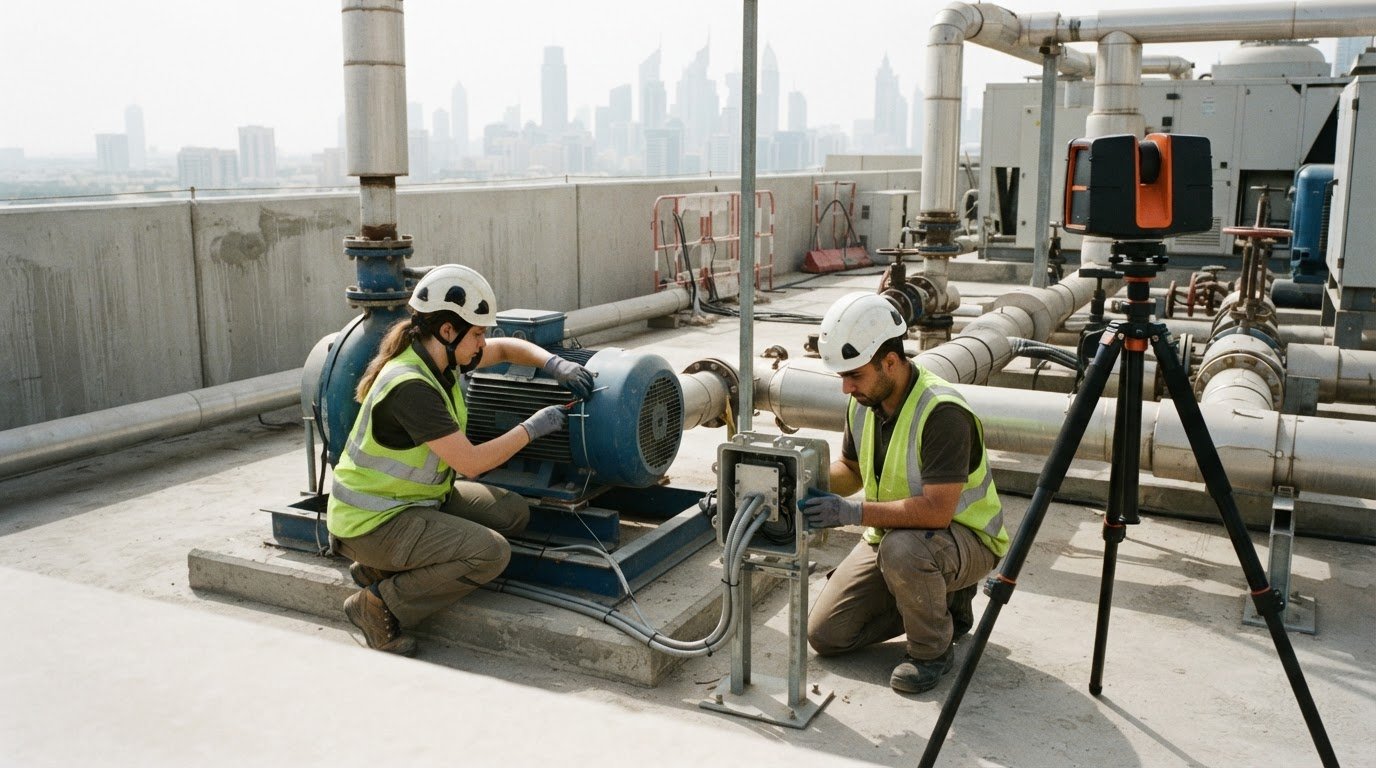
A construction digital twin is more than a 3D model: it connects a digital representation of a building or asset with information that can support decisions throughout its lifecycle. Digital twin implementation services in the UAE bring BIM, IoT data and AI analytics together, using the model as a structured view of the asset, connected sensors to provide current information, and analytics to help identify patterns and potential issues. The result is a practical information environment, not just a visualisation.
For construction teams in Dubai and across the UAE, a digital twin is valuable when it supports real project needs. It can connect design and construction information, improve visibility into site conditions and asset performance, and help teams identify risks earlier. Those benefits depend on more than software: the data, systems, and project workflows must work together.
This guide explains what construction digital twins are, how BIM, IoT, and AI contribute, and which implementation phases turn the concept into a usable project resource. It also covers the factors that shape implementation and how accurate reality capture and Scan-to-BIM can provide a dependable foundation for digital twin work.
Key Takeaways
- Understand how BIM, connected asset data and analytics can work together to support a construction digital twin.
- Identify the implementation phases that turn project information into a useful digital resource.
- Learn where digital twins can improve coordination, visibility and risk management across construction and asset operations.
- See how UAE urban development projects are applying digital twin concepts to buildings, infrastructure and city-scale planning.
- Explore how GEOVERSE Digital Twin and accurate survey data can support a project’s digital twin requirements.
Integration of BIM, IoT data, and AI analytics
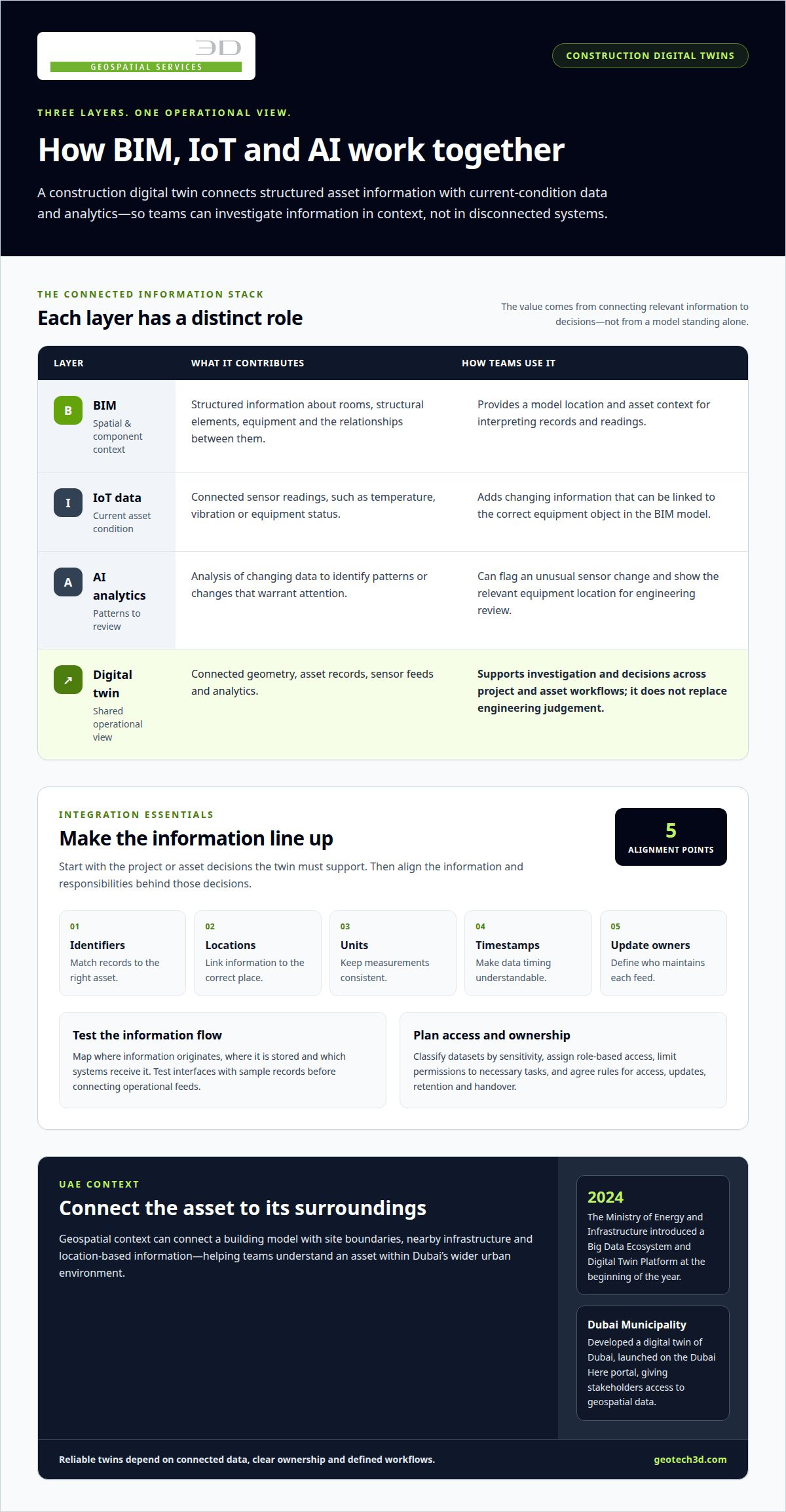
A construction digital twin combines an asset’s structured information with data about its current condition. BIM provides spatial and component context, including rooms, structural elements, equipment, and their relationships. IoT sensors can add readings such as temperature, vibration, or equipment status. AI analytics can examine changing data and identify patterns that warrant attention. Each layer has a distinct role; connecting them gives teams a shared operational view rather than a model that stands alone.
Integration begins by defining which project or asset decisions the twin must support. For example, a facilities team tracking plant-room equipment needs sensor records linked to the correct equipment objects in the BIM model. Teams then align identifiers, locations, units, timestamps, and update responsibilities across systems. Without that alignment, an asset may appear under different names or a reading may map to the wrong component. A defined data structure makes these mismatches easier to detect and resolve.
In the UAE, public digital-twin initiatives provide useful context for this approach. The Ministry of Energy and Infrastructure introduced a Big Data Ecosystem and Digital Twin Platform at the beginning of 2024. Dubai Municipality developed a digital twin of Dubai, launched on the Dubai Here portal, giving stakeholders access to geospatial data. For a construction project, geospatial context can connect a building model to its surroundings, including site boundaries, nearby infrastructure, and location-based information. That context helps teams interpret the asset within Dubai’s wider urban environment.
AI is most useful when its output informs an operational decision. An analytics workflow might compare sensor readings with expected operating patterns, flag an unusual change, and show the relevant equipment location for review. The model supports investigation, but it does not replace engineering judgement. Teams should define which data feeds matter, how often they update, who reviews alerts, and what action follows. This keeps analytics connected to practical maintenance or project workflows instead of producing signals with no assigned response.
Cybersecurity and data sharing also require deliberate planning. A practical implementation can classify datasets by sensitivity, assign role-based access, limit permissions to necessary tasks, and record data exchanges. Integration teams should map where information originates, where it is stored, and which systems receive it. They can then test interfaces with sample records before connecting operational feeds. Clear ownership matters too: project partners need agreed rules for access, updates, retention, and handover, especially when design, construction, and operations teams use different platforms.
For digital twin implementation services in the UAE, the central integration task is keeping geometry, asset records, sensor feeds, and analytics reliably connected. Start with a defined use case, establish data ownership, map system interfaces, and test the information flow. In Dubai, adding geospatial context can make a twin more useful for understanding both an asset and its urban setting.
Construction efficiency, risk reduction, and cost savings
A construction digital twin can improve project visibility by connecting design intent, site progress, and asset information. On a complex build, teams can use a shared model to review spatial conflicts, coordinate work sequences, and compare planned conditions with captured site data. This helps project managers focus on discrepancies before they affect downstream activities. The benefit comes from connecting relevant information to decisions, not simply creating a detailed visual model.
How much does digital twin implementation cost in the UAE? The price depends on the project and is provided after a quote request. Key cost factors include asset size and complexity, existing BIM and survey data, the required level of reality capture, system integrations, sensor coverage, and ongoing data management.
Four-dimensional modelling at Dubai’s One Za’abeel development simulated the design of its towers and 720-foot cantilever bridge. The project’s digital-twin modelling cut 70 days from the construction schedule. This example shows how linking model geometry with time-based planning can help teams examine construction sequences and understand how decisions affect work across a complex structure. It is a project-specific result, not a standard saving for every build.
Risk reduction also depends on information quality and timing. A current site model can help teams locate deviations from design, coordinate access, and review interfaces between building elements. For example, if captured conditions differ from the planned geometry, teams can assess the location and potential impact before related work proceeds. The twin supports earlier investigation; project leaders still make decisions based on engineering review, site conditions, and contract requirements.
For operational assets, connected records can help maintenance teams relate an issue to a location, system, or component. That context can make asset handover more useful than a collection of disconnected files. It also gives owners a structured basis for planning inspections and evaluating changes. The benefits depend on accurate records and clear responsibility for updates throughout construction and operations.
Digital twin technology has also been associated with a 30% improvement in waste recycling rates. For a project team, the practical value lies in using model and site information to identify material flows, monitor waste-related decisions, and improve coordination. The outcome depends on project processes and data quality, so teams should define the target use case before selecting measures.
To assess an implementation, define the decisions it must support, the information required, and who will maintain that information. Teams evaluating digital twin project data requirements can use these questions to frame a practical scope around coordination, risk visibility, and asset handover.
Digital twins in UAE urban development
UAE urban development uses digital twins at different scales, from individual infrastructure networks to emirate-wide models. Construction digital twin adoption in the UAE is 40%, while urban planning adoption is 35%. These figures point to two connected applications: managing information about buildings and infrastructure, and using spatial data to understand how development fits into a wider urban area. Each application needs reliable location data and clear links between assets, records, and decisions.
Dubai’s urban context makes geospatial information especially relevant. Dubai Municipality developed a digital twin of Dubai, launched on the Dubai Here portal, giving stakeholders access to geospatial data. For a development team, city-scale context can help place a building or site within its surroundings. A project model can be viewed alongside nearby roads, land parcels, and infrastructure, supporting coordination across boundaries that a standalone building model may not represent.
Abu Dhabi is developing a related approach at emirate scale. The Department of Municipalities and Transport leads a digital twin project creating a 3D virtual model of the emirate from multiple data sources. Combining those sources can support a more unified spatial view for planning and infrastructure management. The practical task is to align datasets that differ in coverage, update cycles, and detail, then maintain clear relationships between mapped features and the assets they represent.
A specific infrastructure example is the Al-Raha Beach Development potable-water network in Abu Dhabi. The Abu Dhabi government collaborated with AECOM on digital-twin management for the network, and the project helped cut capital costs by 30%. The example shows how a network-focused twin can help teams assess infrastructure information in context. It is a project result, not a universal saving: outcomes depend on the network, available records, and how the model informs planning decisions.
For developers and asset owners, UAE urban projects suggest several practical steps:
- Set the geographic scope. Define whether the twin covers a building, a utility network, a district, or an emirate.
- Connect spatial and asset records. Link mapped features to the information teams need for planning or operations.
- Establish update ownership. Assign responsibility for maintaining records as construction and infrastructure conditions change.
- Choose decisions the twin must support. Use cases might include infrastructure coordination, network planning, or reviewing development within its surroundings.
Dubai Municipality’s city model and Abu Dhabi’s emirate-scale initiative illustrate why geographic context matters. A construction twin can better support urban coordination when assets are understood in relation to surrounding infrastructure and mapped information. The appropriate scope depends on the decisions to be made, the available datasets, and how participating teams will keep information aligned throughout the project lifecycle.
Digital twin implementation phases
UAE digital twin implementation follows a sequence: define the use case, assess data, build the model, connect systems, validate outputs, and plan ongoing updates. Each phase should produce a clear decision or deliverable, moving the project from a defined operational need to a usable digital representation.
UAE providers vary in their strengths across surveying, BIM, software integration, analytics, and asset operations. Platform experience and industries served also shape delivery: a building twin, utility network, and city model require different data and workflows. Compare expertise by how a provider connects these disciplines to the intended project outcome.
Services can range from early consulting and use-case definition to data acquisition, model development, system integration, deployment, and ongoing information management. For a construction asset, this may involve establishing the spatial baseline, structuring asset records, connecting operational feeds, and preparing the model for project or facilities teams.
Project price and timeline depend on the asset’s size and complexity, the condition of existing records, the required survey and model detail, system interfaces, sensor scope, and update requirements. These factors shape the work involved in data capture, model preparation, integration, testing, and handover.
- Define the use case. Identify the decisions the twin must support, such as construction coordination, asset handover, or facilities planning. Set the project boundary and identify users who need access.
- Assess source information. Review available drawings, BIM models, asset registers, and geospatial records. Identify gaps, inconsistent identifiers, or outdated site information that could affect model reliability.
- Establish the digital baseline. Capture or prepare the geometry and asset data required for the selected use case. Define naming conventions, coordinates, data ownership, and the level of detail needed.
- Build and connect. Structure the digital model, then connect relevant data sources through agreed interfaces. Map each feed to the correct location or asset record, and define access roles.
- Validate with a real workflow. Test the twin against a practical task, such as locating an asset or reviewing a construction condition. Resolve mismatches before wider rollout.
- Deploy and maintain. Prepare users, handover information, and update responsibilities. Set a process for recording changes so the twin remains aligned with the physical asset.
These steps explain how implementation works in the UAE: define the use case, assess data, prepare the model, integrate systems, validate outputs, and plan operational handover. The order matters because integration depends on dependable source data, while useful testing requires a defined workflow. A phased plan also clarifies scope: teams can separate essential requirements from later enhancements and link each deliverable to an operational need.
Which companies provide digital twin implementation services in the UAE?
In the UAE, digital twin projects may involve geospatial specialists, engineering consultancies, BIM teams, software integrators, and asset-management providers. One company may handle several disciplines, while larger projects may need coordinated delivery across multiple teams. The expertise required depends on whether the scope covers a building, infrastructure network, construction programme, or urban area.
For construction projects, geospatial and surveying specialists establish accurate site and asset information. BIM teams structure building components and project data. Systems integrators connect models to operational platforms, while analytics specialists configure data workflows for defined decisions. These roles can overlap, but responsibilities should be clear across data capture, model development, integration, testing, and handover.
UAE examples show how different organisations contribute to digital twin initiatives. Dubai Municipality developed Dubai’s city digital twin, made available through the Dubai Here portal. In Abu Dhabi, the Department of Municipalities and Transport leads an emirate-wide 3D model initiative using data from multiple sources. These public-sector programmes demonstrate city-scale applications; they are not a directory of commercial implementation providers.
A project-specific example involves AECOM and the Abu Dhabi government’s digital-twin management of the Al-Raha Beach Development potable-water networks. The case illustrates an engineering consultancy’s role in a defined infrastructure application. It does not mean every firm offers the same scope or works across every asset type. Assess provider expertise through the actual disciplines and deliverables involved.
For digital twin implementation services in the UAE, assess capabilities against project needs rather than relying on a broad label. Relevant areas include:
- Reality capture and spatial data: establishing accurate site geometry and georeferenced information.
- BIM and asset modelling: structuring components, identifiers, and asset records for project use.
- Platform integration: connecting model information with operational systems and data feeds.
- Analytics and workflows: shaping information around specific construction or asset-management decisions.
- Handover and updates: defining how records move into operations and remain current.
These capabilities matter because implementation is not a single software task. A building owner, for example, may need reliable asset records and operational integration, while a municipality may require geospatial coverage across a larger area. Scope, existing information, required integrations, and intended users determine which expertise is central. Clear delivery roles connect each specialist’s work to the project’s intended use.
For a construction team, the practical next step is to define the asset boundary, intended decisions, source information, and required outputs. These details establish whether the project needs primarily spatial capture, BIM development, integration, or a coordinated combination.
GEOTECH 3D: GEOVERSE Digital Twin
GEOVERSE Digital Twin gives construction and asset teams a practical next step when they need a digital representation grounded in project or site information. GEOTECH 3D can support that foundation with a topo survey, 3D Laser Scanning, or Drone Services, depending on the site and the information required. These services are relevant when existing spatial data needs to be captured or updated for a digital twin workflow.
For developers, contractors, consultants, and asset owners in Dubai and the UAE, start with the intended use: define the asset or site, the decisions the twin should support, and the information required. This shapes a project scope around useful data, rather than treating a digital twin as a standalone visual model.
Contact GEOTECH 3D to discuss your digital twin requirements.
Move from a model to a project-ready twin
The next step is to define the decisions your digital twin should help your team make. Set a clear asset boundary, identify who will use the information, and establish how project data will be maintained as conditions change. This creates a focused basis for digital twin implementation services in the UAE, connecting technical scope to your organisation’s construction or asset-management priorities.
GEOVERSE Digital Twin supports teams developing digital representations of sites and assets. A project discussion can establish the intended use, available information, and data foundation for a practical scope. Implementation can then be planned around your workflows and project requirements.
A clearly defined first step helps teams build with purpose and keep the twin connected to real project needs.
Frequently Asked Questions
What are digital twins in the construction industry?
A construction digital twin is a digital representation of a physical building, site, or infrastructure asset, organised to support project or operational decisions. Unlike a static visual model, it can bring together spatial information, asset records, and updates from connected systems. For example, a facilities team could use an equipment’s model location alongside its maintenance record to understand where an issue relates to the building.
What are the process phases of building a digital twin?
Building a digital twin typically moves from a defined use case to data preparation, model development, system connection, testing, and ongoing maintenance. Set a clear acceptance point for each phase to track progress. For example, before connecting live equipment data, confirm that the model identifies the correct assets and locations. This reduces the risk of mismatched records entering operational workflows.
Which UAE industries use digital twins, and what are the main use cases?
UAE digital twin applications include construction, urban planning, utilities, transport, and energy. A developer may use a twin to coordinate building information, while a utility operator can organise network records around mapped assets. City-scale models can support spatial planning, and infrastructure models can provide context for asset management. The best use case depends on the decisions teams need to make and the information relevant to those decisions.
What data, IoT sensors, software, and cloud infrastructure are needed for a digital twin?
Requirements depend on the asset and its intended use. Typical inputs include drawings or BIM, spatial coordinates, asset identifiers, and relevant operational records. IoT sensors may provide readings such as equipment status or environmental conditions when they support a defined task. Software needs to manage the model and connect required data sources. Cloud or hosted infrastructure can support access and integration, while access controls and data ownership should be planned alongside the technical setup.
What are the main implementation risks and challenges for UAE digital twin projects?
Common challenges include incomplete asset records, inconsistent identifiers, disconnected software, unclear data ownership, and cybersecurity exposure. Sensor readings can also mislead teams if devices are poorly located or their outputs lack context. For UAE projects involving multiple partners, define who can access each dataset and who maintains it after handover. Testing a real workflow, such as locating an asset from its record, can reveal integration issues before wider use.
Are there UAE government initiatives or standards supporting digital twin adoption?
UAE initiatives include the Ministry of Energy and Infrastructure’s Big Data Ecosystem and Digital Twin Platform, introduced at the beginning of 2024. Dubai Municipality’s Dubai digital twin is available through the Dubai Here portal, while Abu Dhabi’s Department of Municipalities and Transport leads an emirate-wide 3D model project. These initiatives show public-sector applications. For project delivery, teams should define shared data formats, identifiers, access rules, and update responsibilities for participating systems.
A construction digital twin is more than a 3D model: it connects a digital representation of a building or asset with information that can support decisions throughout its lifecycle. Digital twin implementation services in the UAE bring BIM, IoT data and AI analytics together, using the model as a structured view of the asset, connected sensors to provide current information, and analytics to help identify patterns and potential issues. The result is a practical information environment, not just a visualisation.
For construction teams in Dubai and across the UAE, a digital twin is valuable when it supports real project needs. It can connect design and construction information, improve visibility into site conditions and asset performance, and help teams identify risks earlier. Those benefits depend on more than software: the data, systems, and project workflows must work together.
This guide explains what construction digital twins are, how BIM, IoT, and AI contribute, and which implementation phases turn the concept into a usable project resource. It also covers the factors that shape implementation and how accurate reality capture and Scan-to-BIM can provide a dependable foundation for digital twin work.
Key Takeaways
- Understand how BIM, connected asset data and analytics can work together to support a construction digital twin.
- Identify the implementation phases that turn project information into a useful digital resource.
- Learn where digital twins can improve coordination, visibility and risk management across construction and asset operations.
- See how UAE urban development projects are applying digital twin concepts to buildings, infrastructure and city-scale planning.
- Explore how GEOVERSE Digital Twin and accurate survey data can support a project’s digital twin requirements.
Integration of BIM, IoT data, and AI analytics
A construction digital twin combines an asset’s structured information with data about its current condition. BIM provides spatial and component context, including rooms, structural elements, equipment, and their relationships. IoT sensors can add readings such as temperature, vibration, or equipment status. AI analytics can examine changing data and identify patterns that warrant attention. Each layer has a distinct role; connecting them gives teams a shared operational view rather than a model that stands alone.
Integration begins by defining which project or asset decisions the twin must support. For example, a facilities team tracking plant-room equipment needs sensor records linked to the correct equipment objects in the BIM model. Teams then align identifiers, locations, units, timestamps, and update responsibilities across systems. Without that alignment, an asset may appear under different names or a reading may map to the wrong component. A defined data structure makes these mismatches easier to detect and resolve.
In the UAE, public digital-twin initiatives provide useful context for this approach. The Ministry of Energy and Infrastructure introduced a Big Data Ecosystem and Digital Twin Platform at the beginning of 2024. Dubai Municipality developed a digital twin of Dubai, launched on the Dubai Here portal, giving stakeholders access to geospatial data. For a construction project, geospatial context can connect a building model to its surroundings, including site boundaries, nearby infrastructure, and location-based information. That context helps teams interpret the asset within Dubai’s wider urban environment.
AI is most useful when its output informs an operational decision. An analytics workflow might compare sensor readings with expected operating patterns, flag an unusual change, and show the relevant equipment location for review. The model supports investigation, but it does not replace engineering judgement. Teams should define which data feeds matter, how often they update, who reviews alerts, and what action follows. This keeps analytics connected to practical maintenance or project workflows instead of producing signals with no assigned response.
Cybersecurity and data sharing also require deliberate planning. A practical implementation can classify datasets by sensitivity, assign role-based access, limit permissions to necessary tasks, and record data exchanges. Integration teams should map where information originates, where it is stored, and which systems receive it. They can then test interfaces with sample records before connecting operational feeds. Clear ownership matters too: project partners need agreed rules for access, updates, retention, and handover, especially when design, construction, and operations teams use different platforms.
For digital twin implementation services in the UAE, the central integration task is keeping geometry, asset records, sensor feeds, and analytics reliably connected. Start with a defined use case, establish data ownership, map system interfaces, and test the information flow. In Dubai, adding geospatial context can make a twin more useful for understanding both an asset and its urban setting.
Construction efficiency, risk reduction, and cost savings
A construction digital twin can improve project visibility by connecting design intent, site progress, and asset information. On a complex build, teams can use a shared model to review spatial conflicts, coordinate work sequences, and compare planned conditions with captured site data. This helps project managers focus on discrepancies before they affect downstream activities. The benefit comes from connecting relevant information to decisions, not simply creating a detailed visual model.
How much does digital twin implementation cost in the UAE? The price depends on the project and is provided after a quote request. Key cost factors include asset size and complexity, existing BIM and survey data, the required level of reality capture, system integrations, sensor coverage, and ongoing data management.
Four-dimensional modelling at Dubai’s One Za’abeel development simulated the design of its towers and 720-foot cantilever bridge. The project’s digital-twin modelling cut 70 days from the construction schedule. This example shows how linking model geometry with time-based planning can help teams examine construction sequences and understand how decisions affect work across a complex structure. It is a project-specific result, not a standard saving for every build. Just as in advanced manufacturing—where automated machine simulation firms like rwcinc.com validate complex equipment workflows prior to installation—digital twins reduce risk by testing scenarios virtually before physical execution.
Risk reduction also depends on information quality and timing. A current site model can help teams locate deviations from design, coordinate access, and review interfaces between building elements. For example, if captured conditions differ from the planned geometry, teams can assess the location and potential impact before related work proceeds. The twin supports earlier investigation; project leaders still make decisions based on engineering review, site conditions, and contract requirements.
For operational assets, connected records can help maintenance teams relate an issue to a location, system, or component. That context can make asset handover more useful than a collection of disconnected files. It also gives owners a structured basis for planning inspections and evaluating changes. The benefits depend on accurate records and clear responsibility for updates throughout construction and operations.
Digital twin technology has also been associated with a 30% improvement in waste recycling rates. For a project team, the practical value lies in using model and site information to identify material flows, monitor waste-related decisions, and improve coordination. The outcome depends on project processes and data quality, so teams should define the target use case before selecting measures.
To assess an implementation, define the decisions it must support, the information required, and who will maintain that information. Teams evaluating digital twin project data requirements can use these questions to frame a practical scope around coordination, risk visibility, and asset handover.
Digital twins in UAE urban development
UAE urban development uses digital twins at different scales, from individual infrastructure networks to emirate-wide models. Construction digital twin adoption in the UAE is 40%, while urban planning adoption is 35%. These figures point to two connected applications: managing information about buildings and infrastructure, and using spatial data to understand how development fits into a wider urban area. Each application needs reliable location data and clear links between assets, records, and decisions.
Dubai’s urban context makes geospatial information especially relevant. Dubai Municipality developed a digital twin of Dubai, launched on the Dubai Here portal, giving stakeholders access to geospatial data. For a development team, city-scale context can help place a building or site within its surroundings. A project model can be viewed alongside nearby roads, land parcels, and infrastructure, supporting coordination across boundaries that a standalone building model may not represent.
Abu Dhabi is developing a related approach at emirate scale. The Department of Municipalities and Transport leads a digital twin project creating a 3D virtual model of the emirate from multiple data sources. Combining those sources can support a more unified spatial view for planning and infrastructure management. The practical task is to align datasets that differ in coverage, update cycles, and detail, then maintain clear relationships between mapped features and the assets they represent.
A specific infrastructure example is the Al-Raha Beach Development potable-water network in Abu Dhabi. The Abu Dhabi government collaborated with AECOM on digital-twin management for the network, and the project helped cut capital costs by 30%. The example shows how a network-focused twin can help teams assess infrastructure information in context. It is a project result, not a universal saving: outcomes depend on the network, available records, and how the model informs planning decisions.
For developers and asset owners, UAE urban projects suggest several practical steps:
- Set the geographic scope. Define whether the twin covers a building, a utility network, a district, or an emirate.
- Connect spatial and asset records. Link mapped features to the information teams need for planning or operations.
- Establish update ownership. Assign responsibility for maintaining records as construction and infrastructure conditions change.
- Choose decisions the twin must support. Use cases might include infrastructure coordination, network planning, or reviewing development within its surroundings.
Dubai Municipality’s city model and Abu Dhabi’s emirate-scale initiative illustrate why geographic context matters. A construction twin can better support urban coordination when assets are understood in relation to surrounding infrastructure and mapped information. The appropriate scope depends on the decisions to be made, the available datasets, and how participating teams will keep information aligned throughout the project lifecycle.
Digital twin implementation phases
UAE digital twin implementation follows a sequence: define the use case, assess data, build the model, connect systems, validate outputs, and plan ongoing updates. Each phase should produce a clear decision or deliverable, moving the project from a defined operational need to a usable digital representation.
UAE providers vary in their strengths across surveying, BIM, software integration, analytics, and asset operations. Platform experience and industries served also shape delivery: a building twin, utility network, and city model require different data and workflows. Compare expertise by how a provider connects these disciplines to the intended project outcome.
Services can range from early consulting and use-case definition to data acquisition, model development, system integration, deployment, and ongoing information management. For a construction asset, this may involve establishing the spatial baseline, structuring asset records, connecting operational feeds, and preparing the model for project or facilities teams.
Project price and timeline depend on the asset’s size and complexity, the condition of existing records, the required survey and model detail, system interfaces, sensor scope, and update requirements. These factors shape the work involved in data capture, model preparation, integration, testing, and handover.
- Define the use case. Identify the decisions the twin must support, such as construction coordination, asset handover, or facilities planning. Set the project boundary and identify users who need access.
- Assess source information. Review available drawings, BIM models, asset registers, and geospatial records. Identify gaps, inconsistent identifiers, or outdated site information that could affect model reliability.
- Establish the digital baseline. Capture or prepare the geometry and asset data required for the selected use case. Define naming conventions, coordinates, data ownership, and the level of detail needed.
- Build and connect. Structure the digital model, then connect relevant data sources through agreed interfaces. Map each feed to the correct location or asset record, and define access roles.
- Validate with a real workflow. Test the twin against a practical task, such as locating an asset or reviewing a construction condition. Resolve mismatches before wider rollout.
- Deploy and maintain. Prepare users, handover information, and update responsibilities. Set a process for recording changes so the twin remains aligned with the physical asset.
These steps explain how implementation works in the UAE: define the use case, assess data, prepare the model, integrate systems, validate outputs, and plan operational handover. The order matters because integration depends on dependable source data, while useful testing requires a defined workflow. A phased plan also clarifies scope: teams can separate essential requirements from later enhancements and link each deliverable to an operational need.
Which companies provide digital twin implementation services in the UAE?
In the UAE, digital twin projects may involve geospatial specialists, engineering consultancies, BIM teams, software integrators, and asset-management providers. One company may handle several disciplines, while larger projects may need coordinated delivery across multiple teams. The expertise required depends on whether the scope covers a building, infrastructure network, construction programme, or urban area.
For construction projects, geospatial and surveying specialists establish accurate site and asset information. BIM teams structure building components and project data. Systems integrators connect models to operational platforms, while analytics specialists configure data workflows for defined decisions. These roles can overlap, but responsibilities should be clear across data capture, model development, integration, testing, and handover.
UAE examples show how different organisations contribute to digital twin initiatives. Dubai Municipality developed Dubai’s city digital twin, made available through the Dubai Here portal. In Abu Dhabi, the Department of Municipalities and Transport leads an emirate-wide 3D model initiative using data from multiple sources. These public-sector programmes demonstrate city-scale applications; they are not a directory of commercial implementation providers.
A project-specific example involves AECOM and the Abu Dhabi government’s digital-twin management of the Al-Raha Beach Development potable-water networks. The case illustrates an engineering consultancy’s role in a defined infrastructure application. It does not mean every firm offers the same scope or works across every asset type. Assess provider expertise through the actual disciplines and deliverables involved.
For digital twin implementation services in the UAE, assess capabilities against project needs rather than relying on a broad label. Relevant areas include:
- Reality capture and spatial data: establishing accurate site geometry and georeferenced information.
- BIM and asset modelling: structuring components, identifiers, and asset records for project use.
- Platform integration: connecting model information with operational systems and data feeds.
- Analytics and workflows: shaping information around specific construction or asset-management decisions.
- Handover and updates: defining how records move into operations and remain current.
These capabilities matter because implementation is not a single software task. A building owner, for example, may need reliable asset records and operational integration, while a municipality may require geospatial coverage across a larger area. Scope, existing information, required integrations, and intended users determine which expertise is central. Clear delivery roles connect each specialist’s work to the project’s intended use.
For a construction team, the practical next step is to define the asset boundary, intended decisions, source information, and required outputs. These details establish whether the project needs primarily spatial capture, BIM development, integration, or a coordinated combination.
GEOTECH 3D: GEOVERSE Digital Twin
GEOVERSE Digital Twin gives construction and asset teams a practical next step when they need a digital representation grounded in project or site information. GEOTECH 3D can support that foundation with a topo survey, 3D Laser Scanning, or Drone Services, depending on the site and the information required. These services are relevant when existing spatial data needs to be captured or updated for a digital twin workflow.
For developers, contractors, consultants, and asset owners in Dubai and the UAE, start with the intended use: define the asset or site, the decisions the twin should support, and the information required. This shapes a project scope around useful data, rather than treating a digital twin as a standalone visual model.
Contact GEOTECH 3D to discuss your digital twin requirements.
Move from a model to a project-ready twin
The next step is to define the decisions your digital twin should help your team make. Set a clear asset boundary, identify who will use the information, and establish how project data will be maintained as conditions change. This creates a focused basis for digital twin implementation services in the UAE, connecting technical scope to your organisation’s construction or asset-management priorities.
GEOVERSE Digital Twin supports teams developing digital representations of sites and assets. A project discussion can establish the intended use, available information, and data foundation for a practical scope. Implementation can then be planned around your workflows and project requirements.
A clearly defined first step helps teams build with purpose and keep the twin connected to real project needs.
Frequently Asked Questions
What are digital twins in the construction industry?
A construction digital twin is a digital representation of a physical building, site, or infrastructure asset, organised to support project or operational decisions. Unlike a static visual model, it can bring together spatial information, asset records, and updates from connected systems. For example, a facilities team could use an equipment’s model location alongside its maintenance record to understand where an issue relates to the building.
What are the process phases of building a digital twin?
Building a digital twin typically moves from a defined use case to data preparation, model development, system connection, testing, and ongoing maintenance. Set a clear acceptance point for each phase to track progress. For example, before connecting live equipment data, confirm that the model identifies the correct assets and locations. This reduces the risk of mismatched records entering operational workflows.
Which UAE industries use digital twins, and what are the main use cases?
UAE digital twin applications include construction, urban planning, utilities, transport, and energy. A developer may use a twin to coordinate building information, while a utility operator can organise network records around mapped assets. City-scale models can support spatial planning, and infrastructure models can provide context for asset management. The best use case depends on the decisions teams need to make and the information relevant to those decisions.
What data, IoT sensors, software, and cloud infrastructure are needed for a digital twin?
Requirements depend on the asset and its intended use. Typical inputs include drawings or BIM, spatial coordinates, asset identifiers, and relevant operational records. IoT sensors may provide readings such as equipment status or environmental conditions when they support a defined task. Software needs to manage the model and connect required data sources. Cloud or hosted infrastructure can support access and integration, while access controls and data ownership should be planned alongside the technical setup.
What are the main implementation risks and challenges for UAE digital twin projects?
Common challenges include incomplete asset records, inconsistent identifiers, disconnected software, unclear data ownership, and cybersecurity exposure. Sensor readings can also mislead teams if devices are poorly located or their outputs lack context. For UAE projects involving multiple partners, define who can access each dataset and who maintains it after handover. Testing a real workflow, such as locating an asset from its record, can reveal integration issues before wider use.
Are there UAE government initiatives or standards supporting digital twin adoption?
UAE initiatives include the Ministry of Energy and Infrastructure’s Big Data Ecosystem and Digital Twin Platform, introduced at the beginning of 2024. Dubai Municipality’s Dubai digital twin is available through the Dubai Here portal, while Abu Dhabi’s Department of Municipalities and Transport leads an emirate-wide 3D model project. These initiatives show public-sector applications. For project delivery, teams should define shared data formats, identifiers, access rules, and update responsibilities for participating systems.
Search Now
Error: Contact form not found.