

Our Services
Cost of 3D Laser Scanning per Square Meter in Dubai
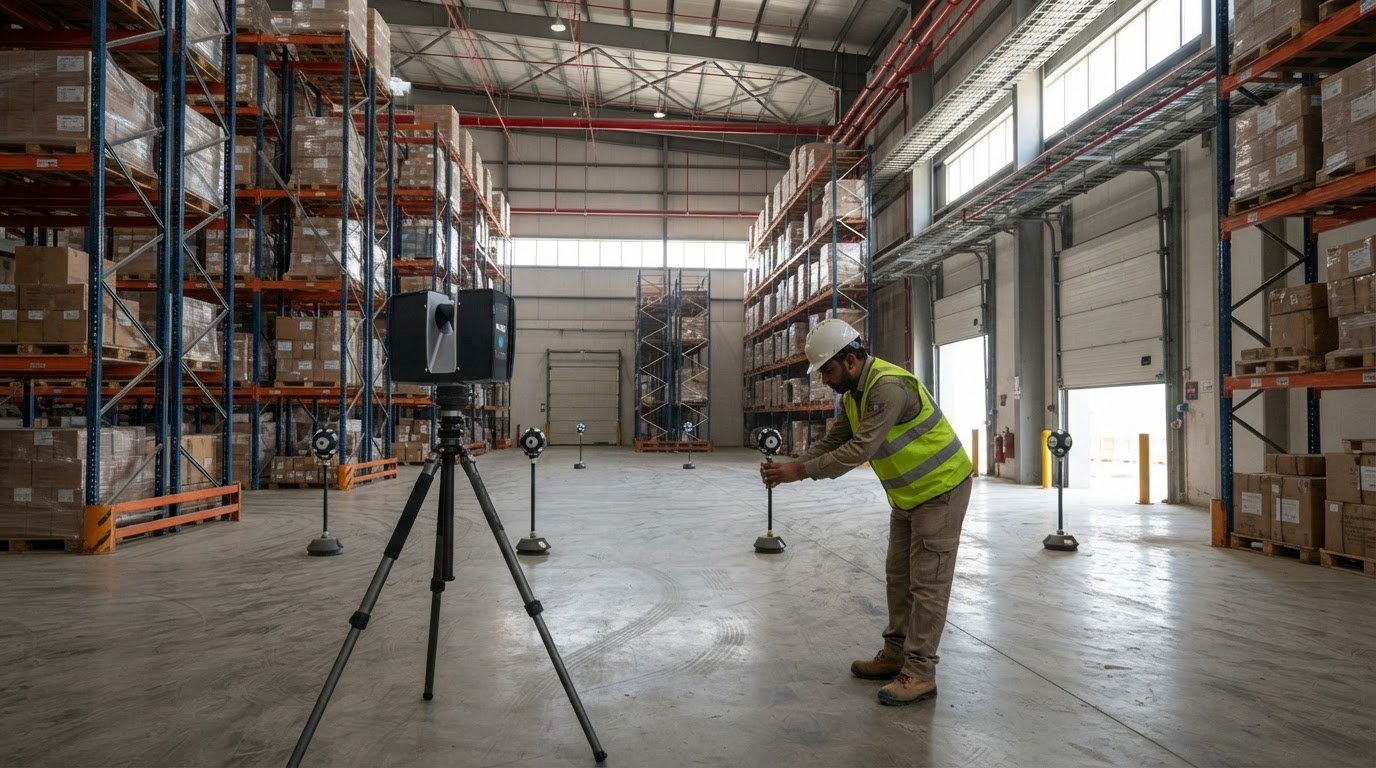
The square-metre rate is only part of the real cost. The cost of 3D laser scanning per square meter in Dubai depends on the project scope, including the building’s size, site access, complexity and required deliverables, rather than a single fixed rate.
It’s also reasonable to ask how long a building scan will take. Larger areas, restricted access and obstacles can affect the number of scan positions and time on site. The requested output also determines the processing and modelling work that follows.
This guide explains how these factors shape project pricing in Dubai and across the UAE, how needs differ between project types, and what point-cloud or model deliverables mean for scope. You’ll also see how building size and access affect scanning time, helping you define the information needed for a project-specific quote.
Key Takeaways
- Understand why a single square-metre rate can’t capture every Dubai scanning project’s scope.
- See how project type and model requirements shape the work and its deliverables.
- Learn how access constraints, obstructions and building complexity influence on-site scan time.
- Recognize why scan data requirements should align with the intended design, coordination or documentation use.
- Explore when 3D laser scanning and Scan To BIM can support a project’s information needs.
Dubai laser scanning cost ranges by project type
In Dubai, estimates are based on project scope, not a universal rate per square metre. A fit-out, office refurbishment and full-building survey involve different coverage, processing and deliverables.
Project-Based Cost Ranges
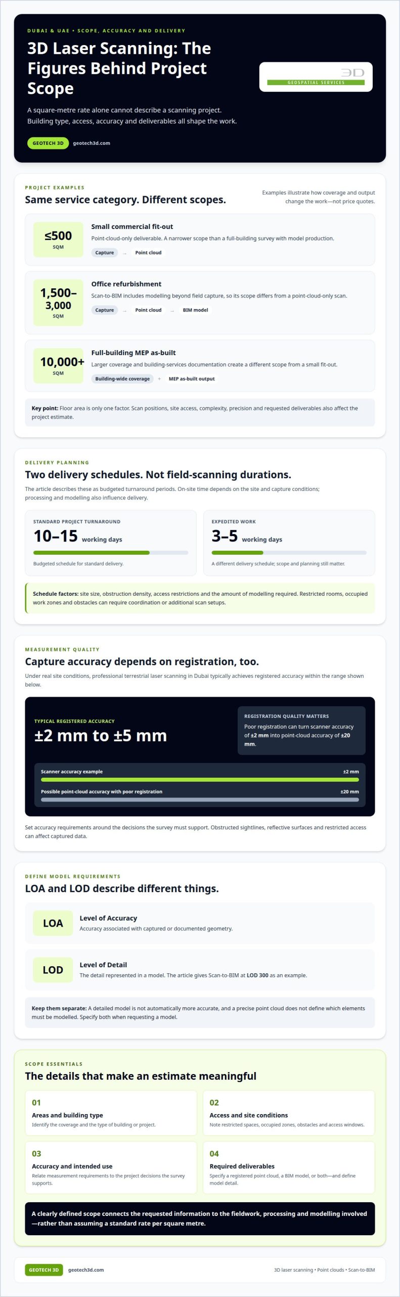
Project-based ranges group estimates by building type, area and required output, helping you compare like with like. A small commercial fit-out of up to 500 sqm with a point-cloud-only deliverable has a narrower scope than a full-building MEP as-built project covering 10,000 sqm or more. A 1,500-3,000 sqm office refurbishment with Scan-to-BIM requires modelling beyond field capture. These examples show how project scope changes; they are not price quotes.
For a UAE estimate, define whether the work covers scanning alone or also point-cloud registration and model production. A heritage building may need detailed capture of complex surfaces, while an open commercial facility may have simpler geometry but wider coverage. Required precision, intended use and access conditions also shape the survey method. That is why a single per-square-metre figure is a poor basis for comparing projects.
Scope-Based Estimates
A scope-based estimate connects the requested coverage and deliverables to the fieldwork and processing involved. Two buildings with the same floor area can require different scan positions, access arrangements and modelling effort. Describe the areas to capture, the required output and any restricted spaces. This gives the estimate a defined basis beyond floor area alone.
For a useful estimate, specify whether the deliverable is a registered point cloud, a BIM model, or both. Include the building type, areas in scope, access limitations and intended use. Laser scanning services can then be scoped around the required information rather than an assumed standard package. The exact figure is provided in a quote for your case, based on scope, access, project complexity and deliverables.
Turnaround also depends on the work after capture. A standard project turnaround is budgeted at 10-15 working days, while expedited work is budgeted at 3-5 working days. These periods describe different delivery schedules, not a universal field-scanning duration. Site size, obstruction density and the amount of modelling required affect how the project is planned.
Building access can affect the schedule even when the survey area stays the same. Restricted rooms, occupied work zones and obstacles may require more coordination or scan setups. A clear office floor and a complex heritage interior, for example, present different capture conditions. Confirming access and deliverables early helps align fieldwork, processing and expectations.
When comparing Dubai estimates, first match the project type, coverage and output. A point-cloud-only fit-out and a full-building MEP model are different scopes, even when their areas are known. A clear scope lets you assess the proposed method, precision requirements and turnaround against the actual project need.
Scoping accuracy, access and model requirements
For an accurate estimate, define the required survey precision, site access and model detail. In Dubai, site permissions depend on ownership and operating arrangements. Coordinate access with the responsible site authority and agree entry windows before scanning.
Information for a project estimate
A clear scope links building conditions to the required deliverables. Include the areas to capture, intended use, accuracy requirements, access limits and whether the output is a point cloud or model. For a commercial interior, identify occupied rooms, restricted zones and areas needing detailed documentation. These details help establish the fieldwork and processing involved.
Describe the model’s purpose, too. Coordination models, existing-condition records and design references can require different levels of detail. For a heritage interior with complex surfaces, specify which elements need representation. A defined scope aligns the survey method with the information users need, rather than assuming every surface requires equal detail.
Scanner accuracy and field conditions
Professional terrestrial laser scanning in Dubai typically achieves registered accuracy of ±2 mm to ±5 mm under real site conditions. Scanner specifications alone don’t determine the final accuracy of a registered point cloud. Poor registration can turn scanner accuracy of ±2 mm into point-cloud accuracy of ±20 mm, making registration quality control essential to reliable data collection.
Accuracy requirements should reflect the decisions the survey must support. A broad existing-condition reference may not need the same measurement tolerance as detailed renovation coordination. Site conditions matter as well: obstructed sightlines, reflective surfaces and restricted access can affect the data captured. State the required accuracy in relation to the intended use, not as an isolated equipment specification.
LOA accuracy and LOD model detail
LOA describes the accuracy associated with captured or documented geometry; LOD describes the detail represented in a model. They answer different questions. A detailed model isn’t automatically more accurate, and a precise point cloud doesn’t define which building elements must be modelled. Specify both requirements separately when requesting a model, such as a Scan-to-BIM output at LOD 300.
This distinction supports quality control. A project can set a tolerance for measured geometry, then define which architectural or building-service elements the model should include. Separating capture accuracy from modelling detail helps align survey data with the final model’s intended use.
Access and capture conditions
Access affects scan coverage and data quality. Locked rooms, active commercial operations and obstructed sightlines can limit visibility from a scan position. Agreeing access windows and restricted areas in advance helps plan capture around site operations and identify areas that may need another setup.
For project planning, 3D laser scanning services can be scoped around the site’s access conditions and required deliverables.
Point clouds and digital models
A point cloud records measured surfaces as spatial points, creating a digital reference for construction, renovation and infrastructure work. Its usefulness depends on how the data is registered, organized and converted into documentation for engineers and project teams.
Point clouds for as-built documentation
For an existing facility, a registered point cloud provides a measurable record of visible conditions at the time of capture. Engineers can use it to review dimensions, identify spatial relationships and plan design work against the surveyed building. A point cloud is not a complete structural model: it represents captured geometry, while interpretation and modelling add organized building elements.
That distinction affects the deliverable. A project needing a visual reference may use the point cloud directly, while renovation coordination may require a structured model. For example, teams documenting an existing commercial floor can use captured geometry as a reference for proposed layouts. The output should match the decisions the documentation needs to support.
Scanner brands and point density
Terrestrial laser scanners capture spatial points to describe visible surfaces, with capture rates varying by scanner specifications and settings. Building coverage depends on scan positions, distance, line of sight and obstructions. A wall hidden behind equipment cannot be represented from a viewpoint that does not capture it. Additional positions can improve coverage where access allows.
Faro, Leica, Trimble and ZEISS are examples of scanner brands used in the market. The brand alone does not determine the completeness or usability of a delivered point cloud. The capture plan, registration process and requested file formats matter, too. For construction teams, these factors influence how readily the data supports measurement, coordination or later modelling.
Capture, processing and model use
Point-cloud production involves more than collecting scans. Individual scan positions must be registered into a coordinated dataset, then reviewed for coverage and consistency. Processing prepares the captured geometry for downstream software. A well-defined scope distinguishes this registered dataset from further interpretation, such as creating a digital model or organizing elements for a particular workflow.
CAD, BIM and GIS describe different working environments, so the required format should match the project’s intended use. A BIM model can organize building elements for design coordination; CAD files can support drawing workflows; GIS data can relate spatial information to wider infrastructure. These outputs are not interchangeable, and each may require different processing or modelling effort.
For project teams, the practical question is what information must be extracted from the captured geometry. A point cloud may suit measurement and existing-condition reference, while a model supports structured review. Defining the output, file format and intended users before capture helps align the data with construction documentation and reduces ambiguity at handover.
Site size, complexity, and number of scan setups
In Dubai, scanning scope depends on site area, complexity, access, required accuracy and deliverables. A large floor can involve more planning and processing across a wider area, while dense obstructions or detailed capture can require additional scan positions. The cost per square metre reflects these combined requirements, not floor area alone.
A typical 3,000 sqm floor plate in Dubai requires one to two working days of on-site scanning, depending on obstruction density, and may need 40-80 scan positions. Each position records visible surfaces from a specific viewpoint. Columns, partitions, equipment and restricted access can affect coverage, so the floor plan and site conditions shape the capture sequence.
How scan setups shape fieldwork
An open floor plate or hall may need 3-4 setups for a large open space. A subdivided floor of similar area presents different sightlines and may need more positions to capture rooms and connecting spaces. Scan positions should overlap by roughly 30% to help software stitch scans together into a registered dataset.
The number of setups also depends on access during the survey. Temporary barriers at a renovation site, for example, may block a planned viewpoint or require the team to capture an area from another position. These conditions affect field capture, registration and the completeness of the measurement record.
Capture, registration and processing
Field scanning is one phase of delivery. Captured positions must be registered and reviewed, then processed into the agreed deliverables. Registration combines separate scans into a coordinated dataset; quality control checks whether the coverage supports the project’s intended use. On-site scanning may finish before processing and any requested modelling are complete.
Planning helps identify coverage gaps before the team leaves the site. A blocked view of a corridor junction, for example, may leave adjoining spaces poorly connected in the dataset. Reviewing scan overlap and visibility as capture progresses can guide additional scan positions while access remains available.
How scan-to-BIM scope affects estimates
A scan-to-BIM scope includes distinct tasks: site capture, registration, data processing and model production. The estimate depends on the deliverables required and the specified model detail. Scanning is not a fixed share of every project budget; the balance between fieldwork and modelling changes with site conditions and requested output.
For a Dubai renovation, define the areas, access conditions, capture requirements and final deliverables together. This clarifies which tasks involve field scanning, which cover data processing, and how site complexity shapes the project schedule and estimate.
3D laser scanning providers in Dubai and the UAE
For Dubai projects, useful comparisons start with the intended outcome, not a headline rate. A residential renovation, industrial facility survey and infrastructure record each require different information. The key is to understand how the proposed scope connects site conditions to the drawings, models or records your team will use.
Match the survey to the project need
Architects may need existing geometry for renovation plans, while contractors may need site information for coordination. Asset teams may require records of visible conditions across an operating facility. Each use calls for a clear capture boundary and defined deliverables. The proposed scope should state which areas the survey covers and what information the resulting data supports.
Existing drawings can help explain a project, but they represent documented design or earlier conditions. A site survey captures visible conditions at the time of measurement. Comparing the two can help teams identify differences that affect design decisions. For example, an architect planning an interior upgrade can use current site data to assess whether available drawings reflect the space being redesigned.
Clarify formats and handover
File formats shape how engineers, architects and contractors use captured information. CAD, BIM and GIS formats serve different workflows, so the project scope should identify the expected handover format and intended users. A point cloud provides a spatial reference; a structured model represents selected elements in an organized form. These outputs are related but not interchangeable.
For an industrial project, teams may need geometry for facility documentation or coordination. Infrastructure work may require spatial data suited to mapping and asset records. Define which structures or features matter, how the data will be used and which formats the project team can work with. This makes the handover more useful than receiving files without a clear role in the workflow.
Assess the proposed method and scope
A well-defined proposal connects site access, capture coverage, required detail and deliverables. It should distinguish field data collection from registration, processing and requested modelling. That separation helps project managers understand the included work and identify scope changes, such as adding an excluded area or requesting additional model elements.
Visibility is another important consideration. Scanning records visible surfaces, so concealed elements are not directly observed geometry. If a design decision depends on hidden services or structural components, the survey scope must distinguish visible information from what requires another source. Clear limits help architects and engineers interpret the resulting documentation responsibly.
Before comparing proposals in Dubai, align them against the same project boundary, use case, formats and deliverables. A like-for-like scope makes differences in method and output easier to assess, without treating floor area as the only measure of value.
GEOTECH 3D: 3D Laser Scanning
GEOTECH 3D provides 3D Laser Scanning for projects that need accurate existing-condition data, from building surveys to renovation planning. When the required outcome includes a structured digital model, Scan To BIM can extend the workflow beyond point-cloud capture.
For a project estimate, define the areas to survey, site access conditions, intended use and required deliverables. These details shape a scope around the building and its information needs, rather than relying on floor area alone. A point cloud may suit measurement and reference, while a BIM model supports model-based coordination.
If you’re planning a Dubai or UAE project, contact GEOTECH 3D to discuss your scanning requirements.
Set Your Project Up for a Clear Next Step
The cost of 3D laser scanning per square meter in Dubai is most useful as a planning consideration when tied to your project’s information needs. Before moving forward, identify which decisions depend on measured site conditions and how the resulting data will be used. That clarity helps align the survey scope with design, construction or asset documentation workflows.
For projects involving more than building interiors, consider how related survey needs fit together. A topo survey can support site context, while Drone Services may suit aerial data capture requirements. Defining these needs alongside scanning requirements gives your project team a more coherent basis for planning deliverables.
GEOTECH 3D can discuss the scope and intended use of your project data, helping you determine a suitable next step for your Dubai or UAE site.
Clear project requirements are a practical starting point for turning site conditions into usable information.
Frequently Asked Questions
What is the price range for 3D laser scanning services in Dubai?
The cost of 3D laser scanning per square meter in Dubai depends on the project scope, so a single rate won’t represent every site. An estimate can change with the areas to capture, site access, required accuracy and whether the deliverable is scan data or a model. For example, a point-cloud-only survey and a project requiring model production involve different work. A project-specific quote should define those inclusions clearly.
How do costs differ for interior, exterior, and façade laser scanning in Dubai?
Interior, exterior and façade scopes differ in coverage, visibility and access. Interior capture may include rooms, corridors and exposed ceiling areas; exterior work covers accessible building surroundings, while façade capture focuses on the building envelope. A mixed-use building, for example, may need separate coverage for interior spaces and elevations. The estimate reflects the agreed areas, capture conditions and output, not the label alone.
Are scan registration, point cloud processing, and BIM modeling included in Dubai scanning quotes?
These items are included only when listed in the defined scope. A handover may cover captured scans, registered point-cloud data, further processing or BIM modelling, depending on project requirements. A team needing only a spatial reference, for example, needs a different deliverable from one requiring a structured building model. Listing each task in the scope makes clear what the quote covers and which files the project team will receive.
What project details are needed to get an accurate 3D laser scanning quote in Dubai?
Share the site location, building type, areas to capture, intended use and required deliverables. Include available drawings, access restrictions, occupied areas and any accuracy or modelling requirements. For a renovation, identifying the floors and rooms in scope helps define coverage; noting restricted rooms clarifies access conditions. These details give the estimate a practical basis and help align the proposed output with your design or documentation workflow.
Which Dubai companies offer 3D laser scanning, and what do their rates include?
GEOTECH 3D offers 3D Laser Scanning and Scan To BIM in Dubai. The scope and deliverables determine what a project estimate includes, such as site capture, point-cloud data or model production. For instance, a team requesting existing-condition data may need a different handover from one planning to use a BIM model. A clearly defined project scope helps establish the included work and the intended files without assuming a standard rate.
The square-metre rate is only part of the real cost. The cost of 3D laser scanning per square meter in Dubai depends on the project scope, including the building’s size, site access, complexity and required deliverables, rather than a single fixed rate.
It’s also reasonable to ask how long a building scan will take. Larger areas, restricted access and obstacles can affect the number of scan positions and time on site. The requested output also determines the processing and modelling work that follows.
This guide explains how these factors shape project pricing in Dubai and across the UAE, how needs differ between project types, and what point-cloud or model deliverables mean for scope. You’ll also see how building size and access affect scanning time, helping you define the information needed for a project-specific quote.
Key Takeaways
- Understand why a single square-metre rate can’t capture every Dubai scanning project’s scope.
- See how project type and model requirements shape the work and its deliverables.
- Learn how access constraints, obstructions and building complexity influence on-site scan time.
- Recognize why scan data requirements should align with the intended design, coordination or documentation use.
- Explore when 3D laser scanning and Scan To BIM can support a project’s information needs.
Dubai laser scanning cost ranges by project type
In Dubai, estimates are based on project scope, not a universal rate per square metre. A fit-out, office refurbishment and full-building survey involve different coverage, processing and deliverables.
Project-Based Cost Ranges
Project-based ranges group estimates by building type, area and required output, helping you compare like with like. A small commercial fit-out of up to 500 sqm with a point-cloud-only deliverable has a narrower scope than a full-building MEP as-built project covering 10,000 sqm or more. A 1,500-3,000 sqm office refurbishment with Scan-to-BIM requires modelling beyond field capture. These examples show how project scope changes; they are not price quotes.
For a UAE estimate, define whether the work covers scanning alone or also point-cloud registration and model production. A heritage building may need detailed capture of complex surfaces, while an open commercial facility may have simpler geometry but wider coverage. Required precision, intended use and access conditions also shape the survey method. That is why a single per-square-metre figure is a poor basis for comparing projects.
Scope-Based Estimates
A scope-based estimate connects the requested coverage and deliverables to the fieldwork and processing involved. Two buildings with the same floor area can require different scan positions, access arrangements and modelling effort. Describe the areas to capture, the required output and any restricted spaces. This gives the estimate a defined basis beyond floor area alone.
For a useful estimate, specify whether the deliverable is a registered point cloud, a BIM model, or both. Include the building type, areas in scope, access limitations and intended use. Laser scanning services can then be scoped around the required information rather than an assumed standard package. The exact figure is provided in a quote for your case, based on scope, access, project complexity and deliverables.
Turnaround also depends on the work after capture. A standard project turnaround is budgeted at 10-15 working days, while expedited work is budgeted at 3-5 working days. These periods describe different delivery schedules, not a universal field-scanning duration. Site size, obstruction density and the amount of modelling required affect how the project is planned.
Building access can affect the schedule even when the survey area stays the same. Restricted rooms, occupied work zones and obstacles may require more coordination or scan setups. A clear office floor and a complex heritage interior, for example, present different capture conditions. Confirming access and deliverables early helps align fieldwork, processing and expectations.
When comparing Dubai estimates, first match the project type, coverage and output. A point-cloud-only fit-out and a full-building MEP model are different scopes, even when their areas are known. A clear scope lets you assess the proposed method, precision requirements and turnaround against the actual project need.
Scoping accuracy, access and model requirements
For an accurate estimate, define the required survey precision, site access and model detail. In Dubai, site permissions depend on ownership and operating arrangements. Coordinate access with the responsible site authority and agree entry windows before scanning.
Information for a project estimate
A clear scope links building conditions to the required deliverables. Include the areas to capture, intended use, accuracy requirements, access limits and whether the output is a point cloud or model. For a commercial interior, identify occupied rooms, restricted zones and areas needing detailed documentation. These details help establish the fieldwork and processing involved.
Describe the model’s purpose, too. Coordination models, existing-condition records and design references can require different levels of detail. For a heritage interior with complex surfaces, specify which elements need representation. A defined scope aligns the survey method with the information users need, rather than assuming every surface requires equal detail.
Scanner accuracy and field conditions
Professional terrestrial laser scanning in Dubai typically achieves registered accuracy of ±2 mm to ±5 mm under real site conditions. Scanner specifications alone don’t determine the final accuracy of a registered point cloud. Poor registration can turn scanner accuracy of ±2 mm into point-cloud accuracy of ±20 mm, making registration quality control essential to reliable data collection.
Accuracy requirements should reflect the decisions the survey must support. A broad existing-condition reference may not need the same measurement tolerance as detailed renovation coordination. Site conditions matter as well: obstructed sightlines, reflective surfaces and restricted access can affect the data captured. State the required accuracy in relation to the intended use, not as an isolated equipment specification.
LOA accuracy and LOD model detail
LOA describes the accuracy associated with captured or documented geometry; LOD describes the detail represented in a model. They answer different questions. A detailed model isn’t automatically more accurate, and a precise point cloud doesn’t define which building elements must be modelled. Specify both requirements separately when requesting a model, such as a Scan-to-BIM output at LOD 300.
This distinction supports quality control. A project can set a tolerance for measured geometry, then define which architectural or building-service elements the model should include. Separating capture accuracy from modelling detail helps align survey data with the final model’s intended use.
Access and capture conditions
Access affects scan coverage and data quality. Locked rooms, active commercial operations and obstructed sightlines can limit visibility from a scan position. Agreeing access windows and restricted areas in advance helps plan capture around site operations and identify areas that may need another setup.
For project planning, 3D laser scanning services can be scoped around the site’s access conditions and required deliverables.
Point clouds and digital models
A point cloud records measured surfaces as spatial points, creating a digital reference for construction, renovation and infrastructure work. Its usefulness depends on how the data is registered, organized and converted into documentation for engineers and project teams.
Point clouds for as-built documentation
For an existing facility, a registered point cloud provides a measurable record of visible conditions at the time of capture. Engineers can use it to review dimensions, identify spatial relationships and plan design work against the surveyed building. A point cloud is not a complete structural model: it represents captured geometry, while interpretation and modelling add organized building elements.
That distinction affects the deliverable. A project needing a visual reference may use the point cloud directly, while renovation coordination may require a structured model. For example, teams documenting an existing commercial floor can use captured geometry as a reference for proposed layouts. The output should match the decisions the documentation needs to support.
Scanner brands and point density
Terrestrial laser scanners capture spatial points to describe visible surfaces, with capture rates varying by scanner specifications and settings. Building coverage depends on scan positions, distance, line of sight and obstructions. A wall hidden behind equipment cannot be represented from a viewpoint that does not capture it. Additional positions can improve coverage where access allows.
Faro, Leica, Trimble and ZEISS are examples of scanner brands used in the market. The brand alone does not determine the completeness or usability of a delivered point cloud. The capture plan, registration process and requested file formats matter, too. For construction teams, these factors influence how readily the data supports measurement, coordination or later modelling.
Capture, processing and model use
Point-cloud production involves more than collecting scans. Individual scan positions must be registered into a coordinated dataset, then reviewed for coverage and consistency. Processing prepares the captured geometry for downstream software. A well-defined scope distinguishes this registered dataset from further interpretation, such as creating a digital model or organizing elements for a particular workflow.
CAD, BIM and GIS describe different working environments, so the required format should match the project’s intended use. A BIM model can organize building elements for design coordination; CAD files can support drawing workflows; GIS data can relate spatial information to wider infrastructure. These outputs are not interchangeable, and each may require different processing or modelling effort.
For project teams, the practical question is what information must be extracted from the captured geometry. A point cloud may suit measurement and existing-condition reference, while a model supports structured review. Defining the output, file format and intended users before capture helps align the data with construction documentation and reduces ambiguity at handover.
Site size, complexity, and number of scan setups
In Dubai, scanning scope depends on site area, complexity, access, required accuracy and deliverables. A large floor can involve more planning and processing across a wider area, while dense obstructions or detailed capture can require additional scan positions. The cost per square metre reflects these combined requirements, not floor area alone.
A typical 3,000 sqm floor plate in Dubai requires one to two working days of on-site scanning, depending on obstruction density, and may need 40-80 scan positions. Each position records visible surfaces from a specific viewpoint. Columns, partitions, equipment and restricted access can affect coverage, so the floor plan and site conditions shape the capture sequence.
How scan setups shape fieldwork
An open floor plate or hall may need 3-4 setups for a large open space. A subdivided floor of similar area presents different sightlines and may need more positions to capture rooms and connecting spaces. Scan positions should overlap by roughly 30% to help software stitch scans together into a registered dataset.
The number of setups also depends on access during the survey. Temporary barriers at a renovation site, for example, may block a planned viewpoint or require the team to capture an area from another position. These conditions affect field capture, registration and the completeness of the measurement record.
Capture, registration and processing
Field scanning is one phase of delivery. Captured positions must be registered and reviewed, then processed into the agreed deliverables. Registration combines separate scans into a coordinated dataset; quality control checks whether the coverage supports the project’s intended use. On-site scanning may finish before processing and any requested modelling are complete.
Planning helps identify coverage gaps before the team leaves the site. A blocked view of a corridor junction, for example, may leave adjoining spaces poorly connected in the dataset. Reviewing scan overlap and visibility as capture progresses can guide additional scan positions while access remains available.
How scan-to-BIM scope affects estimates
A scan-to-BIM scope includes distinct tasks: site capture, registration, data processing and model production. The estimate depends on the deliverables required and the specified model detail. Scanning is not a fixed share of every project budget; the balance between fieldwork and modelling changes with site conditions and requested output.
For a Dubai renovation, define the areas, access conditions, capture requirements and final deliverables together. This clarifies which tasks involve field scanning, which cover data processing, and how site complexity shapes the project schedule and estimate.
3D laser scanning providers in Dubai and the UAE
For Dubai projects, useful comparisons start with the intended outcome, not a headline rate. A residential renovation, industrial facility survey and infrastructure record each require different information. The key is to understand how the proposed scope connects site conditions to the drawings, models or records your team will use.
Match the survey to the project need
Architects may need existing geometry for renovation plans, while contractors may need site information for coordination. Asset teams may require records of visible conditions across an operating facility. Each use calls for a clear capture boundary and defined deliverables. The proposed scope should state which areas the survey covers and what information the resulting data supports.
Existing drawings can help explain a project, but they represent documented design or earlier conditions. A site survey captures visible conditions at the time of measurement. Comparing the two can help teams identify differences that affect design decisions. For example, an architect planning an interior upgrade can use current site data to assess whether available drawings reflect the space being redesigned.
Clarify formats and handover
File formats shape how engineers, architects and contractors use captured information. CAD, BIM and GIS formats serve different workflows, so the project scope should identify the expected handover format and intended users. A point cloud provides a spatial reference; a structured model represents selected elements in an organized form. These outputs are related but not interchangeable.
For an industrial project, teams may need geometry for facility documentation or coordination. Infrastructure work may require spatial data suited to mapping and asset records. Define which structures or features matter, how the data will be used and which formats the project team can work with. This makes the handover more useful than receiving files without a clear role in the workflow.
Assess the proposed method and scope
A well-defined proposal connects site access, capture coverage, required detail and deliverables. It should distinguish field data collection from registration, processing and requested modelling. That separation helps project managers understand the included work and identify scope changes, such as adding an excluded area or requesting additional model elements.
Visibility is another important consideration. Scanning records visible surfaces, so concealed elements are not directly observed geometry. If a design decision depends on hidden services or structural components, the survey scope must distinguish visible information from what requires another source. Clear limits help architects and engineers interpret the resulting documentation responsibly.
Before comparing proposals in Dubai, align them against the same project boundary, use case, formats and deliverables. A like-for-like scope makes differences in method and output easier to assess, without treating floor area as the only measure of value.
GEOTECH 3D: 3D Laser Scanning
GEOTECH 3D provides 3D Laser Scanning for projects that need accurate existing-condition data, from building surveys to renovation planning. When the required outcome includes a structured digital model, Scan To BIM can extend the workflow beyond point-cloud capture.
For a project estimate, define the areas to survey, site access conditions, intended use and required deliverables. These details shape a scope around the building and its information needs, rather than relying on floor area alone. A point cloud may suit measurement and reference, while a BIM model supports model-based coordination.
If you’re planning a Dubai or UAE project, contact GEOTECH 3D to discuss your scanning requirements.
Set Your Project Up for a Clear Next Step
The cost of 3D laser scanning per square meter in Dubai is most useful as a planning consideration when tied to your project’s information needs. Before moving forward, identify which decisions depend on measured site conditions and how the resulting data will be used. That clarity helps align the survey scope with design, construction or asset documentation workflows.
For projects involving more than building interiors, consider how related survey needs fit together. A topo survey can support site context, while Drone Services may suit aerial data capture requirements. Defining these needs alongside scanning requirements gives your project team a more coherent basis for planning deliverables.
GEOTECH 3D can discuss the scope and intended use of your project data, helping you determine a suitable next step for your Dubai or UAE site.
Clear project requirements are a practical starting point for turning site conditions into usable information.
Frequently Asked Questions
What is the price range for 3D laser scanning services in Dubai?
The cost of 3D laser scanning per square meter in Dubai depends on the project scope, so a single rate won’t represent every site. An estimate can change with the areas to capture, site access, required accuracy and whether the deliverable is scan data or a model. For example, a point-cloud-only survey and a project requiring model production involve different work. A project-specific quote should define those inclusions clearly.
How do costs differ for interior, exterior, and façade laser scanning in Dubai?
Interior, exterior and façade scopes differ in coverage, visibility and access. Interior capture may include rooms, corridors and exposed ceiling areas; exterior work covers accessible building surroundings, while façade capture focuses on the building envelope. A mixed-use building, for example, may need separate coverage for interior spaces and elevations. The estimate reflects the agreed areas, capture conditions and output, not the label alone.
Are scan registration, point cloud processing, and BIM modeling included in Dubai scanning quotes?
These items are included only when listed in the defined scope. A handover may cover captured scans, registered point-cloud data, further processing or BIM modelling, depending on project requirements. A team needing only a spatial reference, for example, needs a different deliverable from one requiring a structured building model. Listing each task in the scope makes clear what the quote covers and which files the project team will receive.
What project details are needed to get an accurate 3D laser scanning quote in Dubai?
Share the site location, building type, areas to capture, intended use and required deliverables. Include available drawings, access restrictions, occupied areas and any accuracy or modelling requirements. For a renovation, identifying the floors and rooms in scope helps define coverage; noting restricted rooms clarifies access conditions. These details give the estimate a practical basis and help align the proposed output with your design or documentation workflow.
Which Dubai companies offer 3D laser scanning, and what do their rates include?
GEOTECH 3D offers 3D Laser Scanning and Scan To BIM in Dubai. The scope and deliverables determine what a project estimate includes, such as site capture, point-cloud data or model production. For instance, a team requesting existing-condition data may need a different handover from one planning to use a BIM model. A clearly defined project scope helps establish the included work and the intended files without assuming a standard rate.
Search Now
Error: Contact form not found.