

Our Services
Drone Survey Services for UAE Real Estate Development
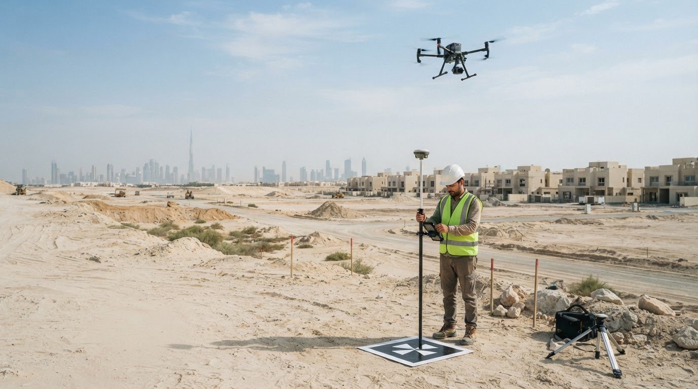
A drone can do more than show a development site from above. A drone survey for real estate development in the UAE can support civil engineering with mapped site conditions, progress records and data for planning and documentation. Its value depends on matching the capture method to the project’s needs and combining aerial data with ground measurements where appropriate.
For complex sites, no single survey method answers every question. Aerial coverage can provide a broad view, while ground surveying and 3D laser scanning add complementary detail for areas or features that need closer measurement.
This article explains how drone surveys support civil engineering and how teams can combine them with ground surveying and laser scanning. It also covers what RGB imagery, LiDAR and volumetric data can contribute, helping you identify outputs that fit your development workflow and connect the survey scope to project requirements.
Key Takeaways
- Use aerial surveys to support civil engineering with site mapping, progress records and measurable project data.
- Combine drone capture with ground surveying and laser scanning to build a more complete picture of site conditions.
- Choose between RGB imagery and LiDAR according to the information the project needs, from visual context to detailed spatial data.
- Plan volumetric data capture around the surfaces and quantities that need to be measured, then align the outputs with project workflows.
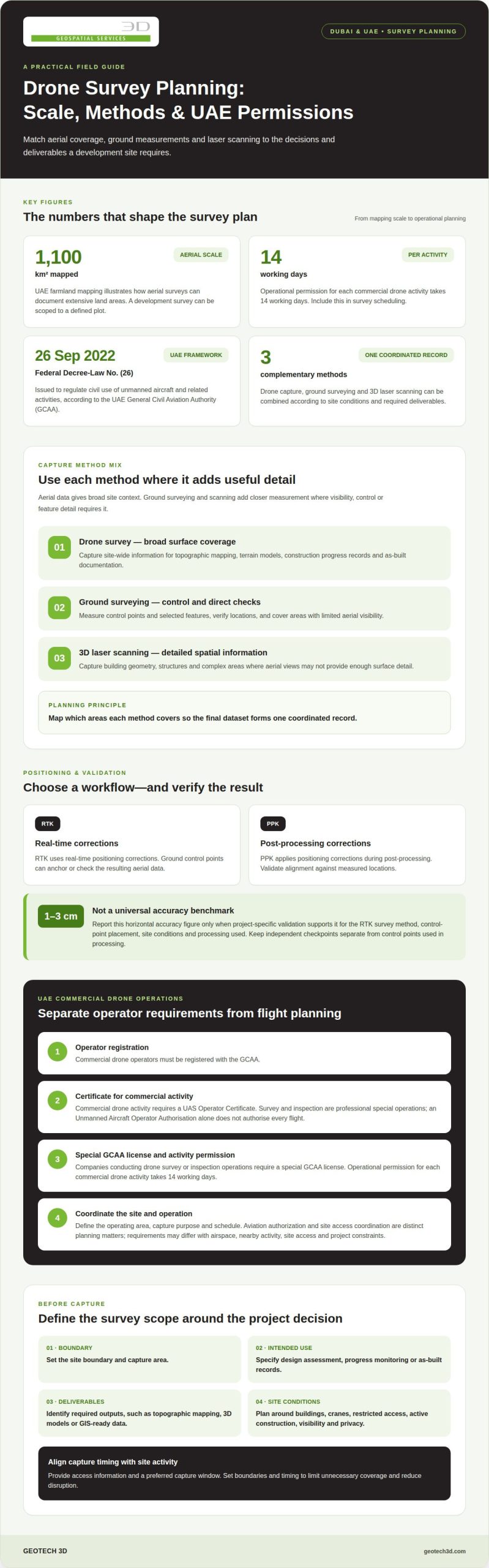
- Account for UAE regulation: according to the General Civil Aviation Authority (GCAA) of the UAE, Federal Decree-Law No. (26) was issued on 26 September 2022 to regulate the civil use of unmanned aircraft and related activities.
Need a Professional Drone Survey or Inspection?
Drone surveying supports real estate development through aerial mapping, construction progress records and as-built documentation. A well-defined scope links each capture to a decision, such as assessing terrain, recording completed work or coordinating design.
Topographic and Terrain Mapping
Topographic mapping records visible site features and terrain across a development parcel. A terrain model helps engineers assess ground levels and understand how the site relates to planned roads, plots and drainage. Before capture, specify the boundary, required detail and intended use. These choices determine the mapping method and the level of accuracy needed for project assessment.
UAE farmland mapping has covered 1,100 km², illustrating how aerial surveys can document extensive land areas. For a real estate site, the same principle scales to a defined plot, with topographic maps and 3D models providing different views of its conditions.
UAE Survey Regulations and Permits
According to the General Civil Aviation Authority (GCAA) of the UAE, UAE Federal Decree-Law No. (26) was issued on 26 September 2022 to regulate the civil use of unmanned aircraft and related activities. Commercial drone operators must be registered with the GCAA, and commercial drone activity requires a UAS Operator Certificate. Survey and inspection are professional special operations; an Unmanned Aircraft Operator Authorisation alone does not authorise every flight.
Operational permission for each commercial drone activity takes 14 working days. Companies conducting drone survey or inspection operations require a special GCAA license. The federal decree regulates civil aircraft use; it does not itself describe municipality-specific project permissions. Aviation authorization and site access coordination are distinct planning matters.
Emirate-Specific Survey Requirements
For sites in Dubai, Abu Dhabi and other emirates, begin with the applicable federal framework, then define the site and planned operation. Requirements may differ by location because airspace, nearby activity, site access and project constraints vary. Include the operating area, capture purpose and schedule in the survey scope, then align the flight plan and coordination with those conditions.
Commissioning a Development Site Survey
Start by defining the boundary and intended use, such as design assessment, progress monitoring or as-built records. Identify required deliverables, including topographic mapping, 3D models or GIS-ready data. Then provide site access information and the preferred capture window. The survey team can use these inputs to plan data collection and applicable operational permissions.
Site conditions also shape safe data capture. Buildings, cranes, restricted access and active construction can affect flight paths and visibility. Consider privacy when imagery may include occupied buildings or neighbouring properties. Set capture boundaries and timing to limit unnecessary coverage, and coordinate the survey around site activity to reduce disruption.
Combining drone surveys with ground surveying and laser scanning
Combining aerial and ground methods connects site-wide context with detailed measurements. On a Dubai development, a drone can capture broad surface coverage, while ground crews measure control points and features needing direct observation. 3D laser scanning adds detailed spatial information for buildings, structures and complex areas. The appropriate combination depends on the survey purpose, site conditions and required deliverables.
Drone capture can collect broad site information faster than ground-only methods, but it does not make ground surveying unnecessary. Ground measurements can establish or verify control, check selected features and cover areas with limited aerial visibility. An inspection plan should show which areas each method covers, so the final dataset forms one coordinated record.
Positioning affects how aerial data aligns with survey control. RTK uses real-time positioning corrections, while PPK applies positioning corrections during post-processing. Ground control points provide known locations that can anchor or check the resulting data. Do not treat 1-3 cm horizontal accuracy as a universal benchmark. Report this figure only when project-specific validation supports it for the RTK survey method, control-point placement, site conditions and processing used.
Independent checkpoints can provide a separate way to assess survey results. Keep them distinct from the control points used in processing, so the team can evaluate alignment against measured locations. This distinction matters when mapped surfaces inform design coordination or progress assessment. Checking a representative site location can show whether the datasets align as intended.
Ground crews remain useful for direct measurement, control establishment and close inspection of specific features. Laser scanning suits detailed capture of building geometry and areas where aerial views lack sufficient surface detail. A development with open earthworks and existing structures, for example, may need aerial coverage across the site, ground measurements for control and scanning for selected structures.
Turnaround depends on site access, capture scope, processing and required detail. Drone flights can cover a broad area faster than ground teams working across the same site, but processing and quality checks still take time. Combining methods can focus fieldwork: use aerial capture for extensive surfaces, then assign ground surveying or scanning to locations that need closer measurement.
- Define the deliverable: map, progress record, or detailed existing-condition model.
- Set control: plan GNSS positioning, ground control points and independent checkpoints.
- Assign methods: match aerial coverage, ground measurements and laser scanning to site features.
For projects that need coordinated aerial and measured site data, explore surveying and mapping services as part of the scope.
LiDAR and RGB sensor data capture
Sensor selection determines what an aerial survey records and how teams can use the results. RGB cameras capture visible colour and surface detail, while LiDAR records spatial measurements as point clouds. A UAE development may need a visual orthomosaic, a terrain representation or data for infrastructure assessment. Let the survey objective guide the sensor choice.
RGB imagery is useful when teams need a clear visual record of site conditions. Overlapping images can be processed through photogrammetry to produce orthomosaics, 3D models and point clouds. For example, an orthomosaic can provide a consistent aerial view for reviewing site boundaries and visible construction progress. Image quality, coverage and ground control influence how well the processed data supports measurement.
LiDAR uses laser measurements to create a point cloud of captured surfaces. This dataset can describe terrain and physical features, including where a visual image alone offers limited spatial information. The project question determines its value: terrain assessment may require broad surface coverage, while an infrastructure review may need focused detail around particular structures. Select LiDAR and RGB together when both visual context and measured geometry matter.
Drone sensors can also include thermal and multispectral equipment, depending on project needs. Thermal data records temperature patterns, while multispectral capture records information across selected bands beyond standard visible imagery. These outputs serve different assessment purposes from RGB mapping or LiDAR geometry. Specify the sensor, target features and deliverable in the capture plan rather than treating sensors as interchangeable.
Processing turns raw aerial capture into information project teams can review. A typical workflow organises imagery or LiDAR data, aligns it to survey control, generates the required model or map, and checks coverage and consistency. For GIS-ready data, define the coordinate reference, feature categories and export requirements early. This helps align mapped site features with the project’s GIS layers.
Advanced processing can use AI to assist with tasks such as classifying visible features or identifying changes between datasets. For instance, a team may compare successive site captures to locate areas where visible construction conditions have changed. Review AI outputs against source imagery and project context: a classification is not automatically a survey measurement or design decision.
- For visual records: specify RGB imagery and any required orthomosaic or 3D model.
- For spatial surfaces: define LiDAR coverage and the point-cloud use.
- For GIS workflows: agree coordinate reference, feature structure and deliverable formats before processing.
Survey drone cameras and LiDAR
Camera and LiDAR choices shape what a development team can measure from aerial data. An RGB camera records visible surface detail, while LiDAR captures spatial measurements as point clouds. The useful question is not which sensor is more advanced, but which dataset answers the project need, whether that is reviewing progress, modelling terrain or estimating volume.
For camera-based mapping, image resolution and capture geometry both matter. A 20MP sensor alone does not establish suitability for orthomosaic or topographic survey work; this depends on the required detail, flight planning, ground control and processing. Photogrammetry software processes overlapping images into orthomosaics, 3D models and point clouds. These products can support site review and surface comparison, while ground control and processing influence the resulting accuracy. Camera imagery also gives teams visible context for interpreting mapped features.
LiDAR’s strength is recording measured points across captured surfaces. For a development parcel, a LiDAR point cloud can represent terrain and built features as spatial data. This is useful when the project needs a surface model rather than only a visual record. Choose a sensor based on the target surfaces, required detail and how the data will feed into design or assessment workflows.
A vertical accuracy of 2-5 cm should be treated as a project-specific requirement, not a general benchmark for survey work. Whether it can be achieved depends on the survey method, positioning, ground control, site conditions and processing. A defensible scope therefore identifies the accuracy requirement and verification approach alongside the sensor. That prevents a camera resolution or sensor label from being mistaken for a complete accuracy statement.
Volume calculations show how sensor data can support construction decisions. A survey team can model a defined surface and compare it with another surface or project reference to assess changes in excavation or stored material. The comparison depends on consistent boundaries, suitable surface data and aligned coordinate references. RGB models can add visual context, while LiDAR data can provide measured point geometry for the selected area.
For progress monitoring, repeat captures should use a consistent site boundary and comparable deliverables. Teams can then review surface changes between dated datasets instead of relying only on separate visual impressions. On a mixed-use development, aerial imagery may show broad work areas, while a terrain model helps assess changing ground surfaces. Choose outputs to suit the decision, not simply the sensor available.
- Choose RGB: when visible detail, orthomosaics or image-based models are central.
- Choose LiDAR: when measured point geometry and terrain representation are priorities.
- For volume and progress: define comparable surfaces, boundaries and ground control before capture.
Which UAE companies provide drone surveying for real estate projects?
UAE real estate developers use specialist geospatial and surveying firms for aerial site data, construction progress monitoring and mapping. Choose a provider whose survey scope matches the project’s decisions and required outputs. For a Dubai development, that could mean documenting earthworks, mapping site features or creating a dated record for progress reviews. Assess the proposed scope, not just the company name.
Start by matching the requested work to the firm’s technical scope. Progress monitoring requires comparable captures over time, while a topographic survey maps site conditions. As-built documentation records conditions after construction work. These are distinct deliverables, so define the purpose, area, features and intended use before fieldwork begins.
A development with open ground and existing structures, for example, may need broad aerial coverage plus detailed measurement of selected areas. The survey team should explain how the capture plan covers both and how the datasets will be processed. If the project needs GIS-ready information, define coordinate references, feature structure and file formats early. This keeps outputs aligned with the project’s mapping workflow.
Progress monitoring also depends on repeatability. Set a consistent site boundary, capture perspective and reporting format for each survey cycle. A dated, georeferenced record lets project teams review conditions and measure changes. Capture schedules can be weekly, fortnightly or monthly, depending on programme intensity. Professional drone capture is planned around site activity and is often timed before a valuation or progress meeting.
Commercial drone survey work in the UAE also involves operational compliance. Commercial operators must be registered with the General Civil Aviation Authority, and survey or inspection operations fall under professional special operations. The GCAA framework and required permissions affect whether a planned flight can proceed. Define the project scope, location and intended capture before scheduling site work.
For a practical scope discussion, define these points with the surveying team:
- Purpose: identify whether the project needs progress records, topographic mapping or as-built documentation.
- Capture area: describe the site boundary and any structures or work zones needing closer coverage.
- Deliverables: specify the models, maps, records or GIS-ready data required.
- Schedule: align repeat capture with construction milestones and site operations.
In Dubai and across the UAE, this structured brief helps connect aerial capture with engineering and development workflows. Discuss your development survey requirements with GEOTECH 3D.
GEOTECH 3D: topo survey
GEOTECH 3D provides topo survey services for development teams that need mapped site conditions to inform planning and design. For a drone survey for real estate development in the UAE, defining the site boundary, intended use and required deliverables gives the survey a clear project purpose. A topo survey can complement aerial data when decisions depend on mapped terrain.
Drone Services and GIS & Surveying Services can support project requirements involving aerial data and mapped information, while real estate strata addresses property subdivision needs. Matching the scope to the project’s intended use helps define the information to capture.
Contact GEOTECH 3D to discuss your development survey requirements.
Turn Survey Data Into a Clear Project Direction
A drone survey for real estate development in the UAE can inform practical decisions when its purpose, outputs and timing are aligned from the outset. Consider how design, construction and asset teams will use the information, then shape the scope around those needs. This keeps survey data connected to the next project action instead of treating capture as an isolated task.
GEOTECH 3D can support this work through Drone Services and topo survey, with 3D Laser Scanning available when detailed spatial information is needed. A defined project boundary, intended use and preferred deliverables provide a useful starting point for discussing the survey scope. The right combination depends on the site and the decisions the data must inform.
With a clear scope, your project team can move forward with a stronger basis for planning and coordination.
Frequently Asked Questions
How are drones used in civil engineering?
Drones support civil engineering when teams need a repeatable aerial record to coordinate work across a site. For example, a project engineer can use a dated survey record to discuss access routes, temporary works areas or changing site boundaries with the construction team. The useful output depends on the coordination decision: define the area to review, identify who needs the information and align capture with the project’s communication process.
What drone survey services are used for real estate development in the UAE?
Real estate projects may require aerial survey, point-cloud survey, progress monitoring or aerial inspection, depending on the asset and task. GEOTECH 3D offers Drone Services, topo survey and real estate strata. For example, a developer handling a property subdivision may need strata-related surveying, while a contractor documenting a building’s visible condition may need an inspection scope. The service should follow the project’s intended use.
What accuracy and deliverables can UAE drone surveys provide?
There is no single accuracy figure for every UAE drone survey. Define the measurement purpose, coordinate reference, units and acceptance criteria in the scope so downstream teams interpret files consistently. Specify deliverables by intended use, such as a model for design coordination or a mapped record for project documentation. Clear naming and revision conventions also help teams distinguish survey updates.
How does drone surveying compare with traditional land surveying in cost, speed, and accuracy?
Drone surveying often suits broad, accessible areas, while ground methods remain useful for isolated points, constrained spaces or features needing direct measurement. Cost depends on the area, capture method, processing and outputs, so compare equivalent scopes. Also consider whether the project needs a single survey or repeated updates, as each approach involves different field and processing tasks.
How are drone survey data and maps used in planning, design, and construction?
Teams can use survey data as a reference layer in project coordination, linking mapped site information with design files or asset records. For a practical handoff, define the coordinate reference, file naming and revision date, then assign responsibility for incorporating the data into the project’s GIS or CAD workflow. This helps engineers and project managers identify which dataset supports each decision and distinguish existing-condition information from design revisions.
A drone can do more than show a development site from above. A drone survey for real estate development in the UAE can support civil engineering with mapped site conditions, progress records and data for planning and documentation. Its value depends on matching the capture method to the project’s needs and combining aerial data with ground measurements where appropriate.
For complex sites, no single survey method answers every question. Aerial coverage can provide a broad view, while ground surveying and 3D laser scanning add complementary detail for areas or features that need closer measurement.
This article explains how drone surveys support civil engineering and how teams can combine them with ground surveying and laser scanning. It also covers what RGB imagery, LiDAR and volumetric data can contribute, helping you identify outputs that fit your development workflow and connect the survey scope to project requirements.
Key Takeaways
- Use aerial surveys to support civil engineering with site mapping, progress records and measurable project data.
- Combine drone capture with ground surveying and laser scanning to build a more complete picture of site conditions.
- Choose between RGB imagery and LiDAR according to the information the project needs, from visual context to detailed spatial data.
- Plan volumetric data capture around the surfaces and quantities that need to be measured, then align the outputs with project workflows.
- Account for UAE regulation: according to the General Civil Aviation Authority (GCAA) of the UAE, Federal Decree-Law No. (26) was issued on 26 September 2022 to regulate the civil use of unmanned aircraft and related activities.
Need a Professional Drone Survey or Inspection?
Drone surveying supports real estate development through aerial mapping, construction progress records and as-built documentation. A well-defined scope links each capture to a decision, such as assessing terrain, recording completed work or coordinating design.
Topographic and Terrain Mapping
Topographic mapping records visible site features and terrain across a development parcel. A terrain model helps engineers assess ground levels and understand how the site relates to planned roads, plots and drainage. Before capture, specify the boundary, required detail and intended use. These choices determine the mapping method and the level of accuracy needed for project assessment.
UAE farmland mapping has covered 1,100 km², illustrating how aerial surveys can document extensive land areas. For a real estate site, the same principle scales to a defined plot, with topographic maps and 3D models providing different views of its conditions.
UAE Survey Regulations and Permits
According to the General Civil Aviation Authority (GCAA) of the UAE, UAE Federal Decree-Law No. (26) was issued on 26 September 2022 to regulate the civil use of unmanned aircraft and related activities. Commercial drone operators must be registered with the GCAA, and commercial drone activity requires a UAS Operator Certificate. Survey and inspection are professional special operations; an Unmanned Aircraft Operator Authorisation alone does not authorise every flight.
Operational permission for each commercial drone activity takes 14 working days. Companies conducting drone survey or inspection operations require a special GCAA license. The federal decree regulates civil aircraft use; it does not itself describe municipality-specific project permissions. Aviation authorization and site access coordination are distinct planning matters.
Emirate-Specific Survey Requirements
For sites in Dubai, Abu Dhabi and other emirates, begin with the applicable federal framework, then define the site and planned operation. Requirements may differ by location because airspace, nearby activity, site access and project constraints vary. Include the operating area, capture purpose and schedule in the survey scope, then align the flight plan and coordination with those conditions.
Commissioning a Development Site Survey
Start by defining the boundary and intended use, such as design assessment, progress monitoring or as-built records. Identify required deliverables, including topographic mapping, 3D models or GIS-ready data. Then provide site access information and the preferred capture window. The survey team can use these inputs to plan data collection and applicable operational permissions.
Site conditions also shape safe data capture. Buildings, cranes, restricted access and active construction can affect flight paths and visibility. Consider privacy when imagery may include occupied buildings or neighbouring properties. Set capture boundaries and timing to limit unnecessary coverage, and coordinate the survey around site activity to reduce disruption.
Combining drone surveys with ground surveying and laser scanning
Combining aerial and ground methods connects site-wide context with detailed measurements. On a Dubai development, a drone can capture broad surface coverage, while ground crews measure control points and features needing direct observation. 3D laser scanning adds detailed spatial information for buildings, structures and complex areas. The appropriate combination depends on the survey purpose, site conditions and required deliverables.
Drone capture can collect broad site information faster than ground-only methods, but it does not make ground surveying unnecessary. Ground measurements can establish or verify control, check selected features and cover areas with limited aerial visibility. An inspection plan should show which areas each method covers, so the final dataset forms one coordinated record.
Positioning affects how aerial data aligns with survey control. RTK uses real-time positioning corrections, while PPK applies positioning corrections during post-processing. Ground control points provide known locations that can anchor or check the resulting data. Do not treat 1-3 cm horizontal accuracy as a universal benchmark. Report this figure only when project-specific validation supports it for the RTK survey method, control-point placement, site conditions and processing used.
Independent checkpoints can provide a separate way to assess survey results. Keep them distinct from the control points used in processing, so the team can evaluate alignment against measured locations. This distinction matters when mapped surfaces inform design coordination or progress assessment. Checking a representative site location can show whether the datasets align as intended.
Ground crews remain useful for direct measurement, control establishment and close inspection of specific features. Laser scanning suits detailed capture of building geometry and areas where aerial views lack sufficient surface detail. A development with open earthworks and existing structures, for example, may need aerial coverage across the site, ground measurements for control and scanning for selected structures.
Turnaround depends on site access, capture scope, processing and required detail. Drone flights can cover a broad area faster than ground teams working across the same site, but processing and quality checks still take time. Combining methods can focus fieldwork: use aerial capture for extensive surfaces, then assign ground surveying or scanning to locations that need closer measurement.
- Define the deliverable: map, progress record, or detailed existing-condition model.
- Set control: plan GNSS positioning, ground control points and independent checkpoints.
- Assign methods: match aerial coverage, ground measurements and laser scanning to site features.
For projects that need coordinated aerial and measured site data, explore surveying and mapping services as part of the scope.
LiDAR and RGB sensor data capture
Sensor selection determines what an aerial survey records and how teams can use the results. RGB cameras capture visible colour and surface detail, while LiDAR records spatial measurements as point clouds. A UAE development may need a visual orthomosaic, a terrain representation or data for infrastructure assessment. Let the survey objective guide the sensor choice.
RGB imagery is useful when teams need a clear visual record of site conditions. Overlapping images can be processed through photogrammetry to produce orthomosaics, 3D models and point clouds. For example, an orthomosaic can provide a consistent aerial view for reviewing site boundaries and visible construction progress. Image quality, coverage and ground control influence how well the processed data supports measurement.
LiDAR uses laser measurements to create a point cloud of captured surfaces. This dataset can describe terrain and physical features, including where a visual image alone offers limited spatial information. The project question determines its value: terrain assessment may require broad surface coverage, while an infrastructure review may need focused detail around particular structures. Select LiDAR and RGB together when both visual context and measured geometry matter.
Drone sensors can also include thermal and multispectral equipment, depending on project needs. Thermal data records temperature patterns, while multispectral capture records information across selected bands beyond standard visible imagery. These outputs serve different assessment purposes from RGB mapping or LiDAR geometry. Specify the sensor, target features and deliverable in the capture plan rather than treating sensors as interchangeable.
Processing turns raw aerial capture into information project teams can review. A typical workflow organises imagery or LiDAR data, aligns it to survey control, generates the required model or map, and checks coverage and consistency. For GIS-ready data, define the coordinate reference, feature categories and export requirements early. This helps align mapped site features with the project’s GIS layers.
Advanced processing can use AI to assist with tasks such as classifying visible features or identifying changes between datasets. For instance, a team may compare successive site captures to locate areas where visible construction conditions have changed. Review AI outputs against source imagery and project context: a classification is not automatically a survey measurement or design decision.
- For visual records: specify RGB imagery and any required orthomosaic or 3D model.
- For spatial surfaces: define LiDAR coverage and the point-cloud use.
- For GIS workflows: agree coordinate reference, feature structure and deliverable formats before processing.
Survey drone cameras and LiDAR
Camera and LiDAR choices shape what a development team can measure from aerial data. An RGB camera records visible surface detail, while LiDAR captures spatial measurements as point clouds. The useful question is not which sensor is more advanced, but which dataset answers the project need, whether that is reviewing progress, modelling terrain or estimating volume.
For camera-based mapping, image resolution and capture geometry both matter. A 20MP sensor alone does not establish suitability for orthomosaic or topographic survey work; this depends on the required detail, flight planning, ground control and processing. Photogrammetry software processes overlapping images into orthomosaics, 3D models and point clouds. These products can support site review and surface comparison, while ground control and processing influence the resulting accuracy. Camera imagery also gives teams visible context for interpreting mapped features.
LiDAR’s strength is recording measured points across captured surfaces. For a development parcel, a LiDAR point cloud can represent terrain and built features as spatial data. This is useful when the project needs a surface model rather than only a visual record. Choose a sensor based on the target surfaces, required detail and how the data will feed into design or assessment workflows.
A vertical accuracy of 2-5 cm should be treated as a project-specific requirement, not a general benchmark for survey work. Whether it can be achieved depends on the survey method, positioning, ground control, site conditions and processing. A defensible scope therefore identifies the accuracy requirement and verification approach alongside the sensor. That prevents a camera resolution or sensor label from being mistaken for a complete accuracy statement.
Volume calculations show how sensor data can support construction decisions. A survey team can model a defined surface and compare it with another surface or project reference to assess changes in excavation or stored material. The comparison depends on consistent boundaries, suitable surface data and aligned coordinate references. RGB models can add visual context, while LiDAR data can provide measured point geometry for the selected area.
For progress monitoring, repeat captures should use a consistent site boundary and comparable deliverables. Teams can then review surface changes between dated datasets instead of relying only on separate visual impressions. On a mixed-use development, aerial imagery may show broad work areas, while a terrain model helps assess changing ground surfaces. Choose outputs to suit the decision, not simply the sensor available.
- Choose RGB: when visible detail, orthomosaics or image-based models are central.
- Choose LiDAR: when measured point geometry and terrain representation are priorities.
- For volume and progress: define comparable surfaces, boundaries and ground control before capture.
Which UAE companies provide drone surveying for real estate projects?
UAE real estate developers use specialist geospatial and surveying firms for aerial site data, construction progress monitoring and mapping. Choose a provider whose survey scope matches the project’s decisions and required outputs. For a Dubai development, that could mean documenting earthworks, mapping site features or creating a dated record for progress reviews. Assess the proposed scope, not just the company name.
Start by matching the requested work to the firm’s technical scope. Progress monitoring requires comparable captures over time, while a topographic survey maps site conditions. As-built documentation records conditions after construction work. These are distinct deliverables, so define the purpose, area, features and intended use before fieldwork begins.
A development with open ground and existing structures, for example, may need broad aerial coverage plus detailed measurement of selected areas. The survey team should explain how the capture plan covers both and how the datasets will be processed. If the project needs GIS-ready information, define coordinate references, feature structure and file formats early. This keeps outputs aligned with the project’s mapping workflow.
Progress monitoring also depends on repeatability. Set a consistent site boundary, capture perspective and reporting format for each survey cycle. A dated, georeferenced record lets project teams review conditions and measure changes. Capture schedules can be weekly, fortnightly or monthly, depending on programme intensity. Professional drone capture is planned around site activity and is often timed before a valuation or progress meeting.
Commercial drone survey work in the UAE also involves operational compliance. Commercial operators must be registered with the General Civil Aviation Authority, and survey or inspection operations fall under professional special operations. The GCAA framework and required permissions affect whether a planned flight can proceed. Define the project scope, location and intended capture before scheduling site work.
For a practical scope discussion, define these points with the surveying team:
- Purpose: identify whether the project needs progress records, topographic mapping or as-built documentation.
- Capture area: describe the site boundary and any structures or work zones needing closer coverage.
- Deliverables: specify the models, maps, records or GIS-ready data required.
- Schedule: align repeat capture with construction milestones and site operations.
In Dubai and across the UAE, this structured brief helps connect aerial capture with engineering and development workflows. Discuss your development survey requirements with GEOTECH 3D.
GEOTECH 3D: topo survey
GEOTECH 3D provides topo survey services for development teams that need mapped site conditions to inform planning and design. For a drone survey for real estate development in the UAE, defining the site boundary, intended use and required deliverables gives the survey a clear project purpose. A topo survey can complement aerial data when decisions depend on mapped terrain.
Drone Services and GIS & Surveying Services can support project requirements involving aerial data and mapped information, while real estate strata addresses property subdivision needs. Matching the scope to the project’s intended use helps define the information to capture.
Contact GEOTECH 3D to discuss your development survey requirements.
Turn Survey Data Into a Clear Project Direction
A drone survey for real estate development in the UAE can inform practical decisions when its purpose, outputs and timing are aligned from the outset. Consider how design, construction and asset teams will use the information, then shape the scope around those needs. This keeps survey data connected to the next project action instead of treating capture as an isolated task.
GEOTECH 3D can support this work through Drone Services and topo survey, with 3D Laser Scanning available when detailed spatial information is needed. A defined project boundary, intended use and preferred deliverables provide a useful starting point for discussing the survey scope. The right combination depends on the site and the decisions the data must inform.
With a clear scope, your project team can move forward with a stronger basis for planning and coordination.
Frequently Asked Questions
How are drones used in civil engineering?
Drones support civil engineering when teams need a repeatable aerial record to coordinate work across a site. For example, a project engineer can use a dated survey record to discuss access routes, temporary works areas or changing site boundaries with the construction team. The useful output depends on the coordination decision: define the area to review, identify who needs the information and align capture with the project’s communication process.
What drone survey services are used for real estate development in the UAE?
Real estate projects may require aerial survey, point-cloud survey, progress monitoring or aerial inspection, depending on the asset and task. GEOTECH 3D offers Drone Services, topo survey and real estate strata. For example, a developer handling a property subdivision may need strata-related surveying, while a contractor documenting a building’s visible condition may need an inspection scope. The service should follow the project’s intended use.
What accuracy and deliverables can UAE drone surveys provide?
There is no single accuracy figure for every UAE drone survey. Define the measurement purpose, coordinate reference, units and acceptance criteria in the scope so downstream teams interpret files consistently. Specify deliverables by intended use, such as a model for design coordination or a mapped record for project documentation. Clear naming and revision conventions also help teams distinguish survey updates.
How does drone surveying compare with traditional land surveying in cost, speed, and accuracy?
Drone surveying often suits broad, accessible areas, while ground methods remain useful for isolated points, constrained spaces or features needing direct measurement. Cost depends on the area, capture method, processing and outputs, so compare equivalent scopes. Also consider whether the project needs a single survey or repeated updates, as each approach involves different field and processing tasks.
How are drone survey data and maps used in planning, design, and construction?
Teams can use survey data as a reference layer in project coordination, linking mapped site information with design files or asset records. For a practical handoff, define the coordinate reference, file naming and revision date, then assign responsibility for incorporating the data into the project’s GIS or CAD workflow. This helps engineers and project managers identify which dataset supports each decision and distinguish existing-condition information from design revisions.
Search Now
Error: Contact form not found.