

Our Services
As-Built Documentation Challenges: Tracking Changes and Gaps
A drawing can be tidy and still fail to show what was actually built. As-built documentation records a completed structure’s existing conditions and changes from the design. Challenges in as-built documentation often arise when dimensions, field changes, or later revisions are missing or outdated. Digital reality capture and online access can help teams keep records aligned with site conditions.
It’s reasonable to expect final drawings to provide a dependable reference. Their usefulness, however, depends on how accurately field information is captured, how changes are tracked, and how deliverables are organised for the people who need them.
This article explains what as-built documentation includes and how dimensional deviations, version control, and file-format coordination affect its reliability. It also explores how 3D scanning, drone-based capture, and online as-builts can support a clearer view of existing conditions across construction and asset management projects in Dubai and the UAE.
Key Takeaways
- Understand how as-built records differ from design drawings and what information makes them useful for facility maintenance.
- Learn how clear records of dimensional deviations and field changes can help teams identify conflicts before they affect later work.
- See why recording change dates, keeping drawing versions current, and reviewing updates matter throughout a project.
- Find out how agreeing on file formats, coordinate systems, and level of detail supports smoother handover between stakeholders.
- Explore how reality capture and online access can help teams work from a more current view of existing conditions.
What Does “As-Built Documentation” Really Mean?
As-built documentation records a building’s completed condition, including changes from its approved design. Design drawings show intended dimensions; as-built drawings show what exists on site. For example, a relocated doorway should appear in the record set, not only in a contractor’s handwritten note. Records can include floor plans, elevations, sections, site information, and relevant structural or building-system details. Their purpose is practical: to give project and facility teams a usable reference for the completed asset.
The documentation can take several forms. A 2D CAD drawing communicates dimensions and locations, while a BIM model can organise building elements as coordinated digital information. A digital twin can bring models and other project data together to represent an asset digitally. These formats serve different needs: a maintenance team locating a valve may use a plan, while a renovation team may need modelled walls, equipment, and services. The challenges in as-built documentation often begin when records are incomplete, hard to interpret, or disconnected from current site conditions.
Facility management relies on records that reflect the actual building. A usable set might show a changed mechanical route, lighting locations, equipment, and access points. When coordinated with facility management software, spatial information can support maintenance and repair planning. Accurate records also help with renovation planning: an engineer can compare the existing layout with a proposed change before decisions are finalised. A record’s value depends on how well it serves its intended task, not simply on whether a drawing or model exists.
There is no single industry-wide standard for as-built documentation; project requirements depend on scope, jurisdiction, and contract. Under the AIA A201 General Conditions, Article 3.11, contractors maintain records of field changes, construction selections, approved shop drawings, and submittals as documentation of the work constructed. For a Dubai project, the governing contract and applicable project requirements define the required deliverables and process.
Requirements differ between countries and regions because local project rules, contract terms, and scope vary. A record set for a building renovation may need different information from one for a site-wide project. In the UAE, define the records’ intended use, content, and acceptance requirements as part of the project documentation process, rather than assuming one format applies everywhere.
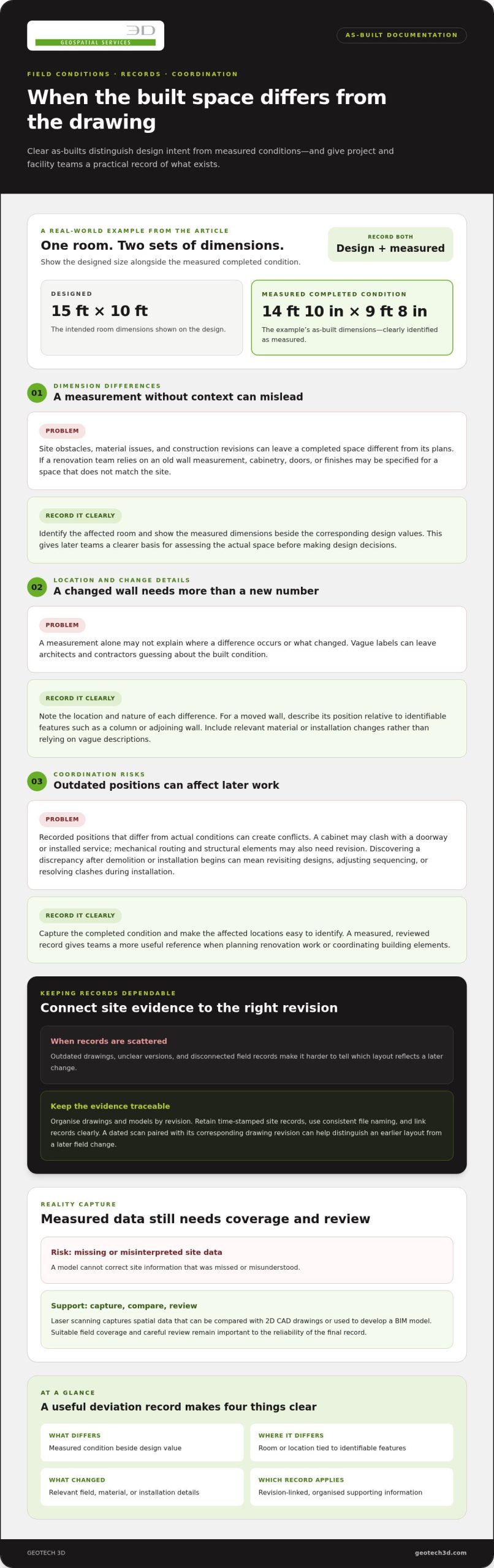
Laser scanning, BIM, and digital tools improve accuracy by connecting measured conditions with structured project information. Laser scanning captures spatial data that can be compared with 2D CAD drawings or used to develop a BIM model. That comparison can reveal a wall, column, or service route that differs from the design. The final record still depends on suitable field coverage and careful review, since a model cannot correct missing or misinterpreted site data on its own.
Digital archives make it easier to trace changes. Teams can organise drawings, models, and supporting records by revision, then retain time-stamped site records alongside them. For example, a dated scan paired with the corresponding drawing revision can help distinguish an earlier layout from a later field change. Consistent file naming and clear links between records also help architects and facility staff find current information without searching through scattered email attachments.
For maintenance, a current digital record can help teams identify relevant building features before work begins. A facilities engineer reviewing a ceiling plan, for example, can compare recorded equipment locations with the space under review. Digital as-builts may also give designers a stronger starting point for future upgrades than outdated drawings. Regular updates after alterations help keep that reference useful as the facility changes.
Recording deviations between designed and completed dimensions
Design drawings show the intended layout; as-built records document measured conditions and changes. Site obstacles, material issues, and construction revisions can all explain why a completed space differs from its plans.
Documenting Dimensional Deviations
Documenting a deviation means recording the measured condition beside the corresponding designed dimension. For example, a condominium room designed at 15 feet by 10 feet might be completed at 14 feet, 10 inches by 9 feet, and 8 inches. A clear drawing should identify the affected room, show the measured dimensions, and distinguish them from design values. This lets a renovation team assess the actual space before specifying cabinetry, doors, or finishes.
Record the location and nature of each difference, not just the changed measurement. If a wall moved, note its position relative to identifiable features, such as a column or adjoining wall. Describe related material or installation changes instead of using vague labels. This gives architects and contractors a useful record of what was built and helps prevent assumptions from carrying into later design work.
Effects of Inaccurate Drawings
Inaccurate drawings can cause coordination conflicts when design decisions rely on dimensions that don’t match the site. A cabinet designed using an old wall measurement, for example, may conflict with a doorway or installed service. Mechanical routing and structural elements may also need revision if their recorded positions differ from actual conditions. Teams may then have to revisit designs, adjust sequencing, or resolve clashes during installation.
When a discrepancy is discovered matters. If it emerges only after demolition or installation begins, work may pause while teams measure, revise drawings, and coordinate affected trades. A contractor may also find that existing conditions require additional labour, materials, or design changes beyond those shown in older plans. Recording deviations before major decisions helps surface coordination issues earlier, while teams can still assess their effects on design and sequencing.
As-Builts and Design Documents
Design documents describe proposed work; as-built documents describe the completed structure as recorded. A design drawing might show a planned partition, while an as-built drawing records its installed position after construction changes. Contractors commonly mark design changes on site, sometimes in red ink, but those notes become useful records only when they are legible, explained, and incorporated into the relevant drawings.
Architects may prepare record drawings using changes previously noted on contractor-created as-builts. The distinction matters during renovation: the design set provides the original intent, while the as-built set supports decisions about existing dimensions and features. Comparing both helps teams identify where a proposed layout relies on an assumption. A clear revision should explain what changed, where it changed, and how the recorded condition differs from the design.
Differences from Site Conditions
As-built documents can still differ from the physical site if field changes aren’t captured, measurements are incomplete, or records are prepared only at project completion. Longer projects create more opportunities for changes to go unrecorded before closeout. Illegible handwritten notes, missing supporting drawings, and disorganised plan sets can also obscure what happened. For example, a later team may find a relocated service that never appeared in the final drawing set.
Treat discrepancies as a prompt to compare the record with current field conditions before relying on it for renovation or installation decisions. Check the affected area, measurements, and related building features, then document any difference clearly. This comparison is especially useful when older drawings conflict with visible site conditions. The aim is a dependable record, not simply a drawing labelled “as-built.”
Version control and change tracking
Every field change needs a traceable place in the project record. Without dates, revision identifiers, and clear ownership, contractors may work from different versions of the same drawing. A dated change history helps teams understand what changed, when it changed, and which record reflects the current condition.
The AIA A201 General Conditions address record keeping in Article 3.11. It requires contractors to maintain documentation of field changes, construction selections, approved shop drawings, and submittals as a record of the work constructed. This is a contractual provision, not a universal rule for every Dubai project. Project teams should define applicable record obligations in their own contract documents and project requirements.
Keep the change record current
Updating as-builts during construction is more reliable than reconstructing months of site decisions at closeout. When a change occurs, record its date, location, reason, and relevant drawing or model revision. For example, if a service route moves to avoid an obstruction, identify the affected area and link the field note to the revised drawing. A vague note such as “route changed” leaves later users without enough context.
A coordinated process links field redlines with the people responsible for drafting and review. Contractors can capture changes as work progresses, while site teams communicate the details needed to update project records. Quality checks then compare the revised documents with available field information. This process can also reveal whether a change appears in one discipline’s drawing but not in related architectural, structural, or mechanical records.
- Identify the record: Give each drawing or model a clear title, revision identifier, and date.
- Describe the change: Note the affected location, what changed, and the supporting field information.
- Control distribution: Make the current approved version distinguishable from superseded records.
- Review closeout: Check that recorded field changes appear in the relevant deliverables.
How tracking limits uncertainty
Version control gives project stakeholders a shared basis for decisions. If an engineer reviews an earlier plan while a contractor uses a later revision, coordination can break down before installation begins. A clear change log makes it easier to identify the applicable drawing and trace how the design evolved. Digital records can support this by retaining revision history and linking updates to relevant project information.
Incomplete records can contribute to unexpected rework, redesign, or change-order discussions when actual conditions differ from the information teams relied on. More complete as-built documentation can reduce uncertainty before construction decisions, but it cannot eliminate every possible change order. In Dubai projects, recording each change and its supporting information helps teams assess its effect on scope and coordination instead of relying on memory or disconnected emails.
After handover, facility teams also need a process for updating digital records when alterations occur. A renovation that changes equipment locations, for example, should prompt a corresponding record update. Otherwise, the archive may describe the previous condition even after the building has changed.
Deliverable formats and stakeholder communication
A reliable handover involves more than producing a drawing or model. Before work begins, project stakeholders should agree on file formats, coordinate systems, and level of detail. These decisions affect how architects, contractors, consultants, and facility teams can use the information during construction and after handover. A file that opens correctly but uses an incompatible coordinate system can still be difficult to align with other project data.
Match formats to intended use
As-built packages may include AutoCAD, Revit, SketchUp, or Rhino files. The right format depends on the recipient’s workflow and intended use. For example, a maintenance team may need searchable digital drawings, while a design team may need a model they can coordinate with proposed work. Agreeing on formats early helps prevent conversion problems and missing information at closeout.
Define the deliverable structure as well as the file extension. Specify which drawings, model elements, schedules, and supporting records belong in the package. A floor plan without relevant equipment details may not meet a facility team’s needs. Similarly, a model with excessive detail can make routine use harder if the recipient needs a clear view of key assets. Agreeing on the level of detail keeps expectations aligned.
Coordinate data across disciplines
In BIM projects, discipline-specific building models can be uploaded to a shared Common Data Environment and combined into a Federated Model. This gives stakeholders a coordinated view of architectural, structural, and building-services information. For example, a project team can review how a mechanical model relates to the architectural layout instead of assessing separate files without context.
Coordination also depends on consistent references. Confirm the project coordinate system, file naming convention, revision identifiers, and folder structure before exchanging information. If one team labels a file by building zone and another uses discipline names, users may struggle to find the current record. A shared naming approach can make the digital archive easier to navigate.
Plan a usable handover
Data portability matters after construction because facility teams may need both digital access and physical records. A practical package can include editable files for future coordination, viewable documents for quick reference, and an organised index explaining each file’s purpose. For example, an asset manager should be able to distinguish the final reflected ceiling plan from a superseded coordination drawing.
AIA contract provisions require as-built documents to be provided to the architect and owner when work concludes. The handover process should identify recipients, required formats, and acceptance checks before closeout. Check that files open, revisions are clear, and linked records remain accessible. In Dubai projects, documenting these expectations in project communications helps each stakeholder understand their role and reduces avoidable confusion at delivery.
Reality mapping and online as-builts
Reality mapping connects captured site conditions with drawings or models, helping project teams compare records with the actual construction. The method can combine laser scanning, drone photogrammetry, BIM data, and online access. Its value lies in making site information easier to review, not merely in producing a visually detailed model.
A practical workflow starts by defining the areas and features the record must cover. Review existing drawings and plan the capture route, including scan positions and reference markers for aligning datasets. Field teams then capture the site, compare the resulting information with available design documents, and investigate discrepancies. Finally, organise reviewed updates into agreed deliverables and make them accessible to relevant project stakeholders.
Capture and verify site information
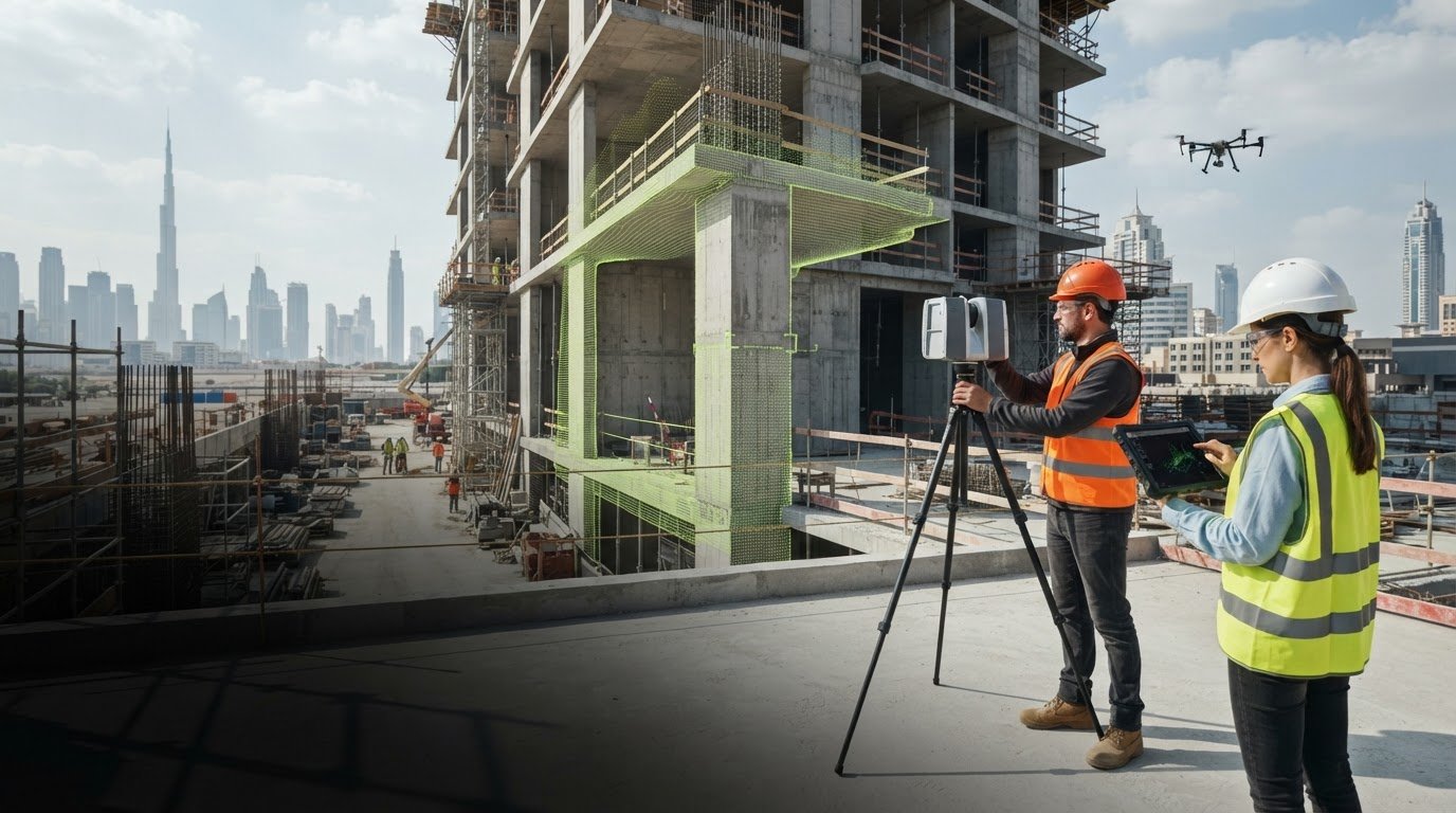
Laser scanning records spatial information across complex interiors, façades, and service areas that can be difficult to measure conventionally. A planned route helps ensure important areas are captured, while reference markers support alignment between scan positions. The resulting point cloud can then be compared with design geometry. For example, a project team might investigate a visible offset between a wall and its modelled position before relying on the model for renovation planning.
Drone photogrammetry offers another way to document suitable construction sites. Overlapping images captured from multiple angles can support the creation of 3D models and point clouds. Flight paths should be planned for site coverage, while the resulting imagery needs review against project information. Neither a scan nor an image set verifies every hidden condition. The capture plan should reflect what the team needs to document and what can be observed safely.
Make the record usable online
An online as-built gives authorised stakeholders a shared way to access and review project information. A cloud-based platform can make drawings, models, and supporting records available without relying on scattered email attachments. Role-based access controls can help manage who views or updates records. Clear file names and revision details remain essential, since online access alone does not show which information is current.
For a construction project, a digital twin can bring together BIM models, drone imagery, and sensor data. Regular updates help keep the digital representation aligned with changing site conditions. During an upgrade, a facilities team could review the model alongside relevant records before planning work. The team still needs to understand the capture date and data coverage, especially if site changes occurred after the latest update.
The key is to treat reality capture as a verification workflow: plan coverage, capture actual conditions, compare results with existing records, resolve differences, and publish reviewed information online. This connects field evidence with usable digital deliverables and makes gaps easier to identify.
GEOTECH 3D: topo survey
GEOTECH 3D provides topo surveys to help project teams document site features and understand existing ground conditions. This is useful when as-built records need a clear site context, such as for planning a site upgrade or coordinating external works. A topo survey complements building-focused records by mapping relevant site information for design and project decisions.
For existing structures, 3D Laser Scanning can capture spatial information for comparison with drawings, while Drone Services can support site data capture. GIS & Surveying Services can help organise geospatial information for project use. The appropriate approach depends on the area being documented and how the resulting information will be used.
To discuss a topo survey for your Dubai or UAE project, contact GEOTECH 3D.
Build a More Reliable Record for What Comes Next
Project information has lasting value when future teams can understand its limitations as well as its contents. Keep records aligned with the decisions they need to support, and make their coverage clear to the people who inherit the asset. This helps address challenges in as-built documentation and gives later planning a stronger starting point.
For developers, contractors, and asset owners in Dubai and across the UAE, the next step is to make documentation part of ongoing asset management. Treat updates as part of the project lifecycle so each future change contributes to a more useful record.
With a clear process and shared ownership, teams can carry reliable project information forward and make better-informed decisions as the asset evolves.
Frequently Asked Questions
Why are As-Constructed Drawings Important?
They help owners understand the scope and configuration handed over, especially when preparing a new work package. For example, a consultant planning a tenant fit-out can use the records to distinguish existing installations from the proposed scope. This supports clearer tender documents and reduces reliance on assumptions by teams unfamiliar with the original construction.
What is as-built documentation in construction?
As-built documentation is the closeout record of the work delivered, organised so future project teams can understand its scope and context. Beyond drawings, useful records can identify the relevant building area, discipline, revision, and source of supporting information. For example, a fit-out handover package can label records by zone and trade. This structure helps future teams find relevant information without treating the package as one undifferentiated file.
What are the most common challenges in creating accurate as-built drawings?
Challenges include documenting concealed work before it becomes inaccessible, reconciling records that use different units or reference points, and linking field evidence to the correct drawing. A photograph or note without a clear location reference may be difficult to interpret later. Defining evidence requirements for concealed installations before work proceeds helps teams capture useful context while the relevant areas are still visible.
How do design changes and RFIs affect as-built documentation?
An RFI response may clarify design intent without changing the installed work, while a resulting field revision may affect the final record. Teams should distinguish the clarification from its implementation. For example, if an RFI resolves a coordination question but the installation remains unchanged, the response may provide context without requiring a revised as-built drawing. If the work changes, link the implemented solution to its supporting decision.
What are the cost and schedule impacts of poor as-built records?
Poor records can complicate procurement and planning even before site work begins. A designer may specify equipment based on an incomplete understanding of existing interfaces, prompting further investigation or a revised scope. During facility operations, unclear records can also make it harder to plan access and coordinate maintenance. The effect depends on which decisions rely on the missing information and how early the gap is identified.
Who is responsible for producing and reviewing as-built drawings?
The project contract and execution plan should allocate responsibility by information type and work package. A responsibility matrix can identify who provides evidence, who consolidates records, and who accepts each deliverable. This is more precise than assigning one person responsibility for every drawing. For example, the matrix can specify a review point for each discipline package before assembling the complete handover set.
What risks arise from incomplete or inaccurate as-built documentation?
One risk is misplaced confidence: a team may treat an old record as definitive without recognising its limitations. That can affect decisions about access, maintenance, or work near existing systems. If information is incomplete, the project team may need further investigation before proceeding. Clearly identifying record dates, coverage, and unresolved areas helps users judge where the documentation is dependable and where further site assessment is needed.
A drawing can be tidy and still fail to show what was actually built. As-built documentation records a completed structure’s existing conditions and changes from the design. Challenges in as-built documentation often arise when dimensions, field changes, or later revisions are missing or outdated. Digital reality capture and online access can help teams keep records aligned with site conditions.
It’s reasonable to expect final drawings to provide a dependable reference. Their usefulness, however, depends on how accurately field information is captured, how changes are tracked, and how deliverables are organised for the people who need them.
This article explains what as-built documentation includes and how dimensional deviations, version control, and file-format coordination affect its reliability. It also explores how 3D scanning, drone-based capture, and online as-builts can support a clearer view of existing conditions across construction and asset management projects in Dubai and the UAE.
Key Takeaways
- Understand how as-built records differ from design drawings and what information makes them useful for facility maintenance.
- Learn how clear records of dimensional deviations and field changes can help teams identify conflicts before they affect later work.
- See why recording change dates, keeping drawing versions current, and reviewing updates matter throughout a project.
- Find out how agreeing on file formats, coordinate systems, and level of detail supports smoother handover between stakeholders.
- Explore how reality capture and online access can help teams work from a more current view of existing conditions.
What Does “As-Built Documentation” Really Mean?
As-built documentation records a building’s completed condition, including changes from its approved design. Design drawings show intended dimensions; as-built drawings show what exists on site. For example, a relocated doorway should appear in the record set, not only in a contractor’s handwritten note. Records can include floor plans, elevations, sections, site information, and relevant structural or building-system details. Their purpose is practical: to give project and facility teams a usable reference for the completed asset.
The documentation can take several forms. A 2D CAD drawing communicates dimensions and locations, while a BIM model can organise building elements as coordinated digital information. A digital twin can bring models and other project data together to represent an asset digitally. These formats serve different needs: a maintenance team locating a valve may use a plan, while a renovation team may need modelled walls, equipment, and services. The challenges in as-built documentation often begin when records are incomplete, hard to interpret, or disconnected from current site conditions.
Facility management relies on records that reflect the actual building. A usable set might show a changed mechanical route, lighting locations, equipment, and access points. When coordinated with facility management software, spatial information can support maintenance and repair planning. Accurate records also help with renovation planning: an engineer can compare the existing layout with a proposed change before decisions are finalised. A record’s value depends on how well it serves its intended task, not simply on whether a drawing or model exists.
There is no single industry-wide standard for as-built documentation; project requirements depend on scope, jurisdiction, and contract. Under the AIA A201 General Conditions, Article 3.11, contractors maintain records of field changes, construction selections, approved shop drawings, and submittals as documentation of the work constructed. For a Dubai project, the governing contract and applicable project requirements define the required deliverables and process.
Requirements differ between countries and regions because local project rules, contract terms, and scope vary. A record set for a building renovation may need different information from one for a site-wide project. In the UAE, define the records’ intended use, content, and acceptance requirements as part of the project documentation process, rather than assuming one format applies everywhere.
Laser scanning, BIM, and digital tools improve accuracy by connecting measured conditions with structured project information. Laser scanning captures spatial data that can be compared with 2D CAD drawings or used to develop a BIM model. That comparison can reveal a wall, column, or service route that differs from the design. The final record still depends on suitable field coverage and careful review, since a model cannot correct missing or misinterpreted site data on its own.
Digital archives make it easier to trace changes. Teams can organise drawings, models, and supporting records by revision, then retain time-stamped site records alongside them. For example, a dated scan paired with the corresponding drawing revision can help distinguish an earlier layout from a later field change. Consistent file naming and clear links between records also help architects and facility staff find current information without searching through scattered email attachments.
For maintenance, a current digital record can help teams identify relevant building features before work begins. A facilities engineer reviewing a ceiling plan, for example, can compare recorded equipment locations with the space under review. Digital as-builts may also give designers a stronger starting point for future upgrades than outdated drawings. Regular updates after alterations help keep that reference useful as the facility changes.
Recording deviations between designed and completed dimensions
Design drawings show the intended layout; as-built records document measured conditions and changes. Site obstacles, material issues, and construction revisions can all explain why a completed space differs from its plans.
Documenting Dimensional Deviations
Documenting a deviation means recording the measured condition beside the corresponding designed dimension. For example, a condominium room designed at 15 feet by 10 feet might be completed at 14 feet, 10 inches by 9 feet, and 8 inches. A clear drawing should identify the affected room, show the measured dimensions, and distinguish them from design values. This lets a renovation team assess the actual space before specifying cabinetry, doors, or finishes.
Record the location and nature of each difference, not just the changed measurement. If a wall moved, note its position relative to identifiable features, such as a column or adjoining wall. Describe related material or installation changes instead of using vague labels. This gives architects and contractors a useful record of what was built and helps prevent assumptions from carrying into later design work.
Effects of Inaccurate Drawings
Inaccurate drawings can cause coordination conflicts when design decisions rely on dimensions that don’t match the site. A cabinet designed using an old wall measurement, for example, may conflict with a doorway or installed service. Mechanical routing and structural elements may also need revision if their recorded positions differ from actual conditions. Teams may then have to revisit designs, adjust sequencing, or resolve clashes during installation.
When a discrepancy is discovered matters. If it emerges only after demolition or installation begins, work may pause while teams measure, revise drawings, and coordinate affected trades. A contractor may also find that existing conditions require additional labour, materials, or design changes beyond those shown in older plans. Recording deviations before major decisions helps surface coordination issues earlier, while teams can still assess their effects on design and sequencing.
As-Builts and Design Documents
Design documents describe proposed work; as-built documents describe the completed structure as recorded. A design drawing might show a planned partition, while an as-built drawing records its installed position after construction changes. Contractors commonly mark design changes on site, sometimes in red ink, but those notes become useful records only when they are legible, explained, and incorporated into the relevant drawings.
Architects may prepare record drawings using changes previously noted on contractor-created as-builts. The distinction matters during renovation: the design set provides the original intent, while the as-built set supports decisions about existing dimensions and features. Comparing both helps teams identify where a proposed layout relies on an assumption. A clear revision should explain what changed, where it changed, and how the recorded condition differs from the design.
Differences from Site Conditions
As-built documents can still differ from the physical site if field changes aren’t captured, measurements are incomplete, or records are prepared only at project completion. Longer projects create more opportunities for changes to go unrecorded before closeout. Illegible handwritten notes, missing supporting drawings, and disorganised plan sets can also obscure what happened. For example, a later team may find a relocated service that never appeared in the final drawing set.
Treat discrepancies as a prompt to compare the record with current field conditions before relying on it for renovation or installation decisions. Check the affected area, measurements, and related building features, then document any difference clearly. This comparison is especially useful when older drawings conflict with visible site conditions. The aim is a dependable record, not simply a drawing labelled “as-built.”
Version control and change tracking
Every field change needs a traceable place in the project record. Without dates, revision identifiers, and clear ownership, contractors may work from different versions of the same drawing. A dated change history helps teams understand what changed, when it changed, and which record reflects the current condition.
The AIA A201 General Conditions address record keeping in Article 3.11. It requires contractors to maintain documentation of field changes, construction selections, approved shop drawings, and submittals as a record of the work constructed. This is a contractual provision, not a universal rule for every Dubai project. Project teams should define applicable record obligations in their own contract documents and project requirements.
Keep the change record current
Updating as-builts during construction is more reliable than reconstructing months of site decisions at closeout. When a change occurs, record its date, location, reason, and relevant drawing or model revision. For example, if a service route moves to avoid an obstruction, identify the affected area and link the field note to the revised drawing. A vague note such as “route changed” leaves later users without enough context.
A coordinated process links field redlines with the people responsible for drafting and review. Contractors can capture changes as work progresses, while site teams communicate the details needed to update project records. Quality checks then compare the revised documents with available field information. This process can also reveal whether a change appears in one discipline’s drawing but not in related architectural, structural, or mechanical records.
- Identify the record: Give each drawing or model a clear title, revision identifier, and date.
- Describe the change: Note the affected location, what changed, and the supporting field information.
- Control distribution: Make the current approved version distinguishable from superseded records.
- Review closeout: Check that recorded field changes appear in the relevant deliverables.
How tracking limits uncertainty
Version control gives project stakeholders a shared basis for decisions. If an engineer reviews an earlier plan while a contractor uses a later revision, coordination can break down before installation begins. A clear change log makes it easier to identify the applicable drawing and trace how the design evolved. Digital records can support this by retaining revision history and linking updates to relevant project information.
Incomplete records can contribute to unexpected rework, redesign, or change-order discussions when actual conditions differ from the information teams relied on. More complete as-built documentation can reduce uncertainty before construction decisions, but it cannot eliminate every possible change order. In Dubai projects, recording each change and its supporting information helps teams assess its effect on scope and coordination instead of relying on memory or disconnected emails.
After handover, facility teams also need a process for updating digital records when alterations occur. A renovation that changes equipment locations, for example, should prompt a corresponding record update. Otherwise, the archive may describe the previous condition even after the building has changed.
Deliverable formats and stakeholder communication
A reliable handover involves more than producing a drawing or model. Before work begins, project stakeholders should agree on file formats, coordinate systems, and level of detail. These decisions affect how architects, contractors, consultants, and facility teams can use the information during construction and after handover. A file that opens correctly but uses an incompatible coordinate system can still be difficult to align with other project data.
Match formats to intended use
As-built packages may include AutoCAD, Revit, SketchUp, or Rhino files. The right format depends on the recipient’s workflow and intended use. For example, a maintenance team may need searchable digital drawings, while a design team may need a model they can coordinate with proposed work. Agreeing on formats early helps prevent conversion problems and missing information at closeout.
Define the deliverable structure as well as the file extension. Specify which drawings, model elements, schedules, and supporting records belong in the package. A floor plan without relevant equipment details may not meet a facility team’s needs. Similarly, a model with excessive detail can make routine use harder if the recipient needs a clear view of key assets. Agreeing on the level of detail keeps expectations aligned.
Coordinate data across disciplines
In BIM projects, discipline-specific building models can be uploaded to a shared Common Data Environment and combined into a Federated Model. This gives stakeholders a coordinated view of architectural, structural, and building-services information. For example, a project team can review how a mechanical model relates to the architectural layout instead of assessing separate files without context.
Coordination also depends on consistent references. Confirm the project coordinate system, file naming convention, revision identifiers, and folder structure before exchanging information. If one team labels a file by building zone and another uses discipline names, users may struggle to find the current record. A shared naming approach can make the digital archive easier to navigate.
Plan a usable handover
Data portability matters after construction because facility teams may need both digital access and physical records. A practical package can include editable files for future coordination, viewable documents for quick reference, and an organised index explaining each file’s purpose. For example, an asset manager should be able to distinguish the final reflected ceiling plan from a superseded coordination drawing.
AIA contract provisions require as-built documents to be provided to the architect and owner when work concludes. To safeguard project deliverables, advisory partners such as Hodge Construction Management & Consulting often assist owners in coordinating handover requirements and acceptance checks before closeout. Check that files open, revisions are clear, and linked records remain accessible. In Dubai projects, documenting these expectations in project communications helps each stakeholder understand their role and reduces avoidable confusion at delivery.
Reality mapping and online as-builts
Reality mapping connects captured site conditions with drawings or models, helping project teams compare records with the actual construction. The method can combine laser scanning, drone photogrammetry, BIM data, and online access. Its value lies in making site information easier to review, not merely in producing a visually detailed model.
A practical workflow starts by defining the areas and features the record must cover. Review existing drawings and plan the capture route, including scan positions and reference markers for aligning datasets. Field teams then capture the site, compare the resulting information with available design documents, and investigate discrepancies. Finally, organise reviewed updates into agreed deliverables and make them accessible to relevant project stakeholders.
Capture and verify site information
Laser scanning records spatial information across complex interiors, façades, and service areas that can be difficult to measure conventionally. A planned route helps ensure important areas are captured, while reference markers support alignment between scan positions. The resulting point cloud can then be compared with design geometry. For example, a project team might investigate a visible offset between a wall and its modelled position before relying on the model for renovation planning.
Drone photogrammetry offers another way to document suitable construction sites. Overlapping images captured from multiple angles can support the creation of 3D models and point clouds. Flight paths should be planned for site coverage, while the resulting imagery needs review against project information. Neither a scan nor an image set verifies every hidden condition. The capture plan should reflect what the team needs to document and what can be observed safely.
Make the record usable online
An online as-built gives authorised stakeholders a shared way to access and review project information. A cloud-based platform can make drawings, models, and supporting records available without relying on scattered email attachments. Role-based access controls can help manage who views or updates records. Clear file names and revision details remain essential, since online access alone does not show which information is current.
For a construction project, a digital twin can bring together BIM models, drone imagery, and sensor data. Regular updates help keep the digital representation aligned with changing site conditions. During an upgrade, a facilities team could review the model alongside relevant records before planning work. The team still needs to understand the capture date and data coverage, especially if site changes occurred after the latest update.
The key is to treat reality capture as a verification workflow: plan coverage, capture actual conditions, compare results with existing records, resolve differences, and publish reviewed information online. This connects field evidence with usable digital deliverables and makes gaps easier to identify.
GEOTECH 3D: topo survey
GEOTECH 3D provides topo surveys to help project teams document site features and understand existing ground conditions. This is useful when as-built records need a clear site context, such as for planning a site upgrade or coordinating external works. A topo survey complements building-focused records by mapping relevant site information for design and project decisions.
For existing structures, 3D Laser Scanning can capture spatial information for comparison with drawings, while Drone Services can support site data capture. GIS & Surveying Services can help organise geospatial information for project use. The appropriate approach depends on the area being documented and how the resulting information will be used.
To discuss a topo survey for your Dubai or UAE project, contact GEOTECH 3D.
Build a More Reliable Record for What Comes Next
Project information has lasting value when future teams can understand its limitations as well as its contents. Keep records aligned with the decisions they need to support, and make their coverage clear to the people who inherit the asset. This helps address challenges in as-built documentation and gives later planning a stronger starting point.
For developers, contractors, and asset owners in Dubai and across the UAE, the next step is to make documentation part of ongoing asset management. Treat updates as part of the project lifecycle so each future change contributes to a more useful record.
With a clear process and shared ownership, teams can carry reliable project information forward and make better-informed decisions as the asset evolves.
Frequently Asked Questions
Why are As-Constructed Drawings Important?
They help owners understand the scope and configuration handed over, especially when preparing a new work package. For example, a consultant planning a tenant fit-out can use the records to distinguish existing installations from the proposed scope. This supports clearer tender documents and reduces reliance on assumptions by teams unfamiliar with the original construction.
What is as-built documentation in construction?
As-built documentation is the closeout record of the work delivered, organised so future project teams can understand its scope and context. Beyond drawings, useful records can identify the relevant building area, discipline, revision, and source of supporting information. For example, a fit-out handover package can label records by zone and trade. This structure helps future teams find relevant information without treating the package as one undifferentiated file.
What are the most common challenges in creating accurate as-built drawings?
Challenges include documenting concealed work before it becomes inaccessible, reconciling records that use different units or reference points, and linking field evidence to the correct drawing. A photograph or note without a clear location reference may be difficult to interpret later. Defining evidence requirements for concealed installations before work proceeds helps teams capture useful context while the relevant areas are still visible.
How do design changes and RFIs affect as-built documentation?
An RFI response may clarify design intent without changing the installed work, while a resulting field revision may affect the final record. Teams should distinguish the clarification from its implementation. For example, if an RFI resolves a coordination question but the installation remains unchanged, the response may provide context without requiring a revised as-built drawing. If the work changes, link the implemented solution to its supporting decision.
What are the cost and schedule impacts of poor as-built records?
Poor records can complicate procurement and planning even before site work begins. A designer may specify equipment based on an incomplete understanding of existing interfaces, prompting further investigation or a revised scope. During facility operations, unclear records can also make it harder to plan access and coordinate maintenance. The effect depends on which decisions rely on the missing information and how early the gap is identified.
Who is responsible for producing and reviewing as-built drawings?
The project contract and execution plan should allocate responsibility by information type and work package. A responsibility matrix can identify who provides evidence, who consolidates records, and who accepts each deliverable. This is more precise than assigning one person responsibility for every drawing. For example, the matrix can specify a review point for each discipline package before assembling the complete handover set.
What risks arise from incomplete or inaccurate as-built documentation?
One risk is misplaced confidence: a team may treat an old record as definitive without recognising its limitations. That can affect decisions about access, maintenance, or work near existing systems. If information is incomplete, the project team may need further investigation before proceeding. Clearly identifying record dates, coverage, and unresolved areas helps users judge where the documentation is dependable and where further site assessment is needed.
Search Now
Error: Contact form not found.