

Our Services
Construction Site Monitoring for Progress and Environmental Conditions
Environmental conditions can change before visible construction progress does. The best practices for construction site monitoring combine regular inspections with consistent records of dust, noise, vibration, water conditions, and completed work. Together, these records help teams spot changes early and respond with relevant evidence.
For projects in Dubai and across the UAE, monitoring matters because construction can affect both the worksite and its surroundings. Capture baseline conditions before work begins to establish a reference point. Continued observations then help teams identify changes and decide when mitigation or closer inspection may be needed.
This guide explains how to compare site progress with the project schedule, inspect environmental and physical conditions, and organize records so observations stay connected to locations, activities, and decisions. It also covers how surveying, 3D capture, and geospatial data can support a clearer view of project changes over time.
Key Takeaways
- Compare observed work with the project baseline and connect each update to its zone, trade, and planned activity.
- Use regular site inspections alongside photos, 360-degree walks, or aerial captures to document conditions that remote monitoring may miss.
- Keep dated reports, meeting decisions, safety records, and site observations organized with consistent naming and version control.
- Establish environmental baselines and track changing conditions so teams can identify impacts and guide appropriate mitigation.
- Use surveying and geospatial capture to create clearer records of site conditions and progress across a project.
Definition and Purpose of Construction Progress Monitoring
Construction progress monitoring records completed work and compares it with the project schedule, quality requirements, and site conditions. A clear baseline gives the team a consistent reference for measuring changes and identifying activities that need attention.
Progress Measurement and KPIs
Progress measurement uses objective field observations to compare completed work with planned activities and construction KPIs. For example, a team can compare installed work in a zone with the scheduled task, then record any delay or incomplete inspection. Accurate, location-based measures help project managers distinguish actual progress from general impressions and identify where schedule, budget, or quality needs closer review.
Progress Photography
Progress photography creates a dated visual record of work, field conditions, safety practices, and quality checks. Images are more useful when linked to a location, trade, and planned activity, such as electrical installation in a named floor zone. Unlabelled photographs can obscure context, so organize them consistently to compare changes and discuss specific observations. Reusing a viewpoint can also make changes easier to review.
Manual and Aerial Progress Tracking
Manual site walks, photographs, 360-degree interior captures, and drone flights document different parts of a project. A walk can reveal interior installation details, while aerial views can show exterior sequencing, facade work, logistics, or visible utility work. Drone coverage complements rather than replaces ground inspections. Align capture timing with project phases and milestones so teams can compare meaningful changes and interpret each record in context.
Safety and Incident Tracking
Construction safety software can log accidents and near-misses, helping teams identify recurring concerns. Each report should include the time, site area, and relevant activity, along with follow-up actions. For example, several reports from one work zone can prompt a focused review of work practices. Clear records also support safety briefings and help teams track whether assigned actions were completed.
Activity, Progress, and Resource Tracking
Activity tracking links each observation to a site zone, trade, and scheduled task. Compare field records with the baseline to identify completed, active, or delayed work, then note relevant crews, equipment, and materials. For example, a mechanical installation update can specify its location and planned activity. This context helps explain schedule differences and resource needs without relying on broad completion estimates.
Monitoring Scope, Costs, and Risks
Monitoring scope defines what teams observe, how they collect records, and who can access them. For UAE projects, consider monitoring requirements alongside approved project documents and applicable authority conditions. Do not assume one permit or approval covers every monitoring method. Site coverage can also connect progress and quality observations with equipment and materials in their respective zones.
Construction monitoring costs vary with project scope, duration, complexity, and management setup. Manage privacy and data-security risks by defining camera purposes, data access, and retention practices. Clear records of how monitoring information is collected and used also help teams review decisions and responsibilities.
Regular Construction Site Inspections
Regular inspections turn site observations into timely decisions about work methods, hazards, quality, and changing conditions. A consistent routine helps project teams assess what is happening on the ground, rather than relying only on schedule updates or remote images.
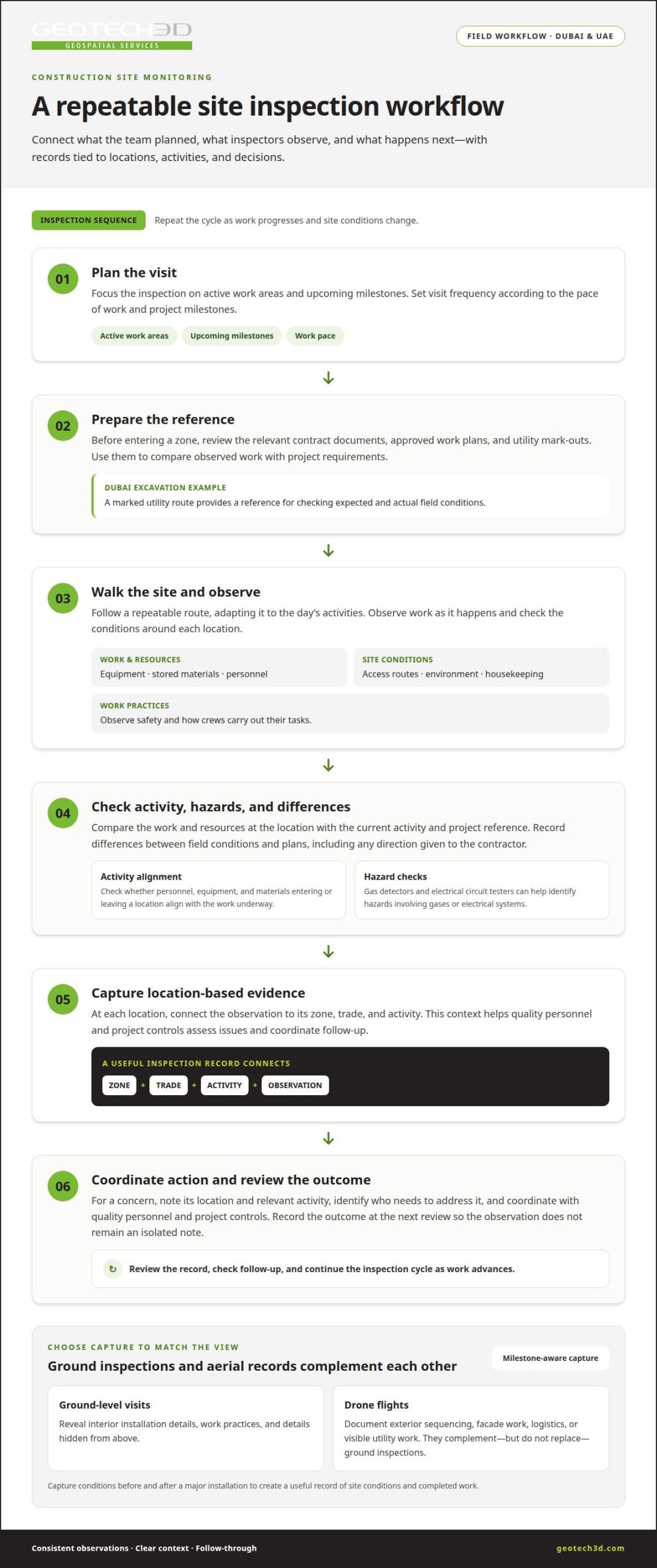
Plan each visit around active work areas and upcoming milestones. Before entering a zone, review the relevant contract documents, approved work plans, and utility mark-outs. These provide a reference for comparing observed work with project requirements. For example, during excavation in Dubai, a marked utility route can help reveal differences between expected and actual field conditions.
Follow a repeatable route through the site, adapting it to the day’s activities. Inspect equipment, stored materials, access routes, environmental conditions, and work practices. Observe housekeeping and safety as crews carry out their tasks. At each location, record the zone, trade, activity, and observation. This context helps project controls and quality personnel assess issues and coordinate follow-up.
Set inspection frequency according to the pace of work and project milestones. Capturing conditions before and after a major installation, for example, creates a useful record of site conditions and completed work. Drone flights can document exterior sequencing, but they do not replace ground-level observation of interior trades or details hidden from above.
During each inspection, assess whether the personnel, equipment, and materials entering or leaving a work location align with the current activity. Gas detectors and electrical circuit testers can help identify hazards involving gases or electrical systems. If field conditions differ from plans, document the observation and any direction given to the contractor. This is particularly useful when an underground utility is missing from a mark-out.
A strong inspection record connects observations to corrective actions. If a concern relates to a specific installation, note its location, relevant activity, and who needs to address it. Coordinate findings with quality personnel and project controls, then record the outcome at the next review. This prevents a field observation from becoming an isolated note.
For example, if an inspection in a Dubai building identifies a crack in a concrete column, record its location and condition, then escalate the finding through the project’s established process. The responsible team can assess the observation, decide on appropriate follow-up, and document the outcome. Clear records distinguish a monitored condition from a completed corrective action and give project personnel a reliable basis for review.
For multi-unit properties, real estate strata documentation can help organize unit and common-area information relevant to site inspections.
How to Organize and Archive Site Monitoring Documents
A reliable record system connects daily field observations with decisions, actions, and project documents. On a UAE construction project, dated logs and consistent file names help teams retrieve the right record when reviewing a work zone, contractor activity, or site condition.
Conduct walkthroughs at the start and end of each workday. The opening walk can record active trades, access conditions, and planned work; the closing walk captures progress, changed conditions, and unresolved issues. Submit the daily field report to the main office by close of business or before the next day’s start-up to keep the work period traceable.
Build each field report around verifiable details, not general impressions. Record the observation time, site location, work activity, subcontractors, and visitors. Link findings to the relevant contract requirement or construction document. Include results from pre-construction surveys, utility mark-outs, special inspections, and directions given when actual conditions differ from plans.
Meeting minutes should document decisions and ownership. For each discussion, record the decision, required action, responsible party, and deadline. For example, if a meeting assigns a drainage correction in a particular zone, identify the zone and action owner in the minutes. Dated records let project teams trace an issue from discussion through resolution.
Safety reports support prompt response and continuous improvement. When monitoring identifies a hazard or incident, document its location, conditions, and relevant activity, then notify the responsible project personnel promptly so they can take appropriate action. Keep the outcome with the original report. Reviewing incident records over time can reveal recurring patterns and inform future briefings.
Vandalism or stolen property also needs clear documentation. Keep descriptions and serial numbers for tools and equipment stored on site. If an item is missing or damaged, record when and where it was discovered and notify the project management office and, when needed, local authorities. Linking the report to an equipment record can make follow-up more precise.
Archive monitoring documents throughout project execution, not just at handover. Use a consistent naming convention that includes the date, site area, document type, and revision where relevant. Apply version control so teams can distinguish current drawings from obsolete copies. Define record access and retention, then link photographs, notes, logs, and meeting records to the relevant locations and activities.
Spreadsheets may suit a simple project, but simultaneous edits can create version conflicts across teams or sites. Keep progress records complete, connected, and accessible through a controlled filing process. A dated archive gives project staff a usable history of observations, decisions, and actions throughout the work.
Monitoring Static and Dynamic Construction Environments
Environmental monitoring compares site conditions with a pre-construction baseline and tracks changes during active work. It helps project teams identify emerging impacts and choose appropriate mitigation methods.
Static and Dynamic Site Conditions
Static conditions describe the site before work begins; dynamic conditions change as construction progresses. A pre-construction survey can record baseline measures such as air and water quality, noise, and vibration. During construction, repeated observations show whether dust, noise, runoff, or vibration has changed. Comparing similar locations and conditions makes the records more useful for assessing impacts.
Set the baseline before mobilization and use the same monitoring locations in later surveys. For example, record noise near a neighboring property before work starts, then take comparable measurements during noisy activities. Monitoring surface water and groundwater can also help identify potential contamination. A topo survey adds spatial context by documenting existing site levels and terrain before earthworks alter them.
Environmental Protection and Risk Mitigation
Environmental protection pairs monitoring with actions to address observed or anticipated impacts. Teams can use baseline results to identify sensitive locations, then relate new readings to nearby activities. If monitoring indicates a negative impact, they can choose an appropriate response, such as dust control, noise barriers, water treatment, or erosion control.
Review monitoring plans as work phases and site conditions change. Dust deposition checks can inform dust controls, while baseline noise and vibration measurements provide comparison points during construction. For example, vibration observations near existing structures can prompt closer assessment when excavation methods or equipment change. Link each finding to its location, activity, and mitigation response.
IoT sensors can support ongoing environmental monitoring by collecting readings at selected locations. Depending on the sensor, teams can track dust-related conditions, noise, water measurements, toxic gas levels, or extreme temperatures. Sensors can also detect structural instability. Interpret readings in context by recording the sensor location, monitored condition, and nearby work activity, rather than treating an isolated reading as a complete assessment.
Use monitoring results to guide risk reviews and follow-up. When readings change, inspect the area, compare results with baseline conditions, and apply an appropriate mitigation measure. Review alert thresholds regularly as site conditions evolve, and update the monitoring plan when new construction phases introduce different risks. This keeps environmental records relevant throughout the work.
GEOTECH 3D
GEOTECH 3D can support construction teams in Dubai and across the UAE with geospatial data for understanding site conditions and documenting change. Its topo survey, 3D Laser Scanning, Drone Services, and GIS & Surveying Services address different monitoring needs. The appropriate approach depends on the project area, the information required, and how teams will use the resulting data.
A topo survey establishes site levels and spatial context for project planning or monitoring. It is useful when earthworks, grading, or changes to the site layout need to be assessed against existing ground conditions. Teams can use the survey as a reference for interpreting site changes and coordinating information across relevant work areas.
3D Laser Scanning can capture the geometry of built spaces and physical structures. It can be relevant when teams need a detailed record of existing conditions or a basis for reviewing spatial relationships on site. For example, scans can help document structural or interior conditions where direct measurements alone may not provide the same level of spatial context.
Drone Services can support aerial surveying when a project needs an overview of exterior areas or site layout. Aerial data helps teams review visible surface conditions and understand how areas relate spatially. It is one part of a monitoring approach, not a replacement for site inspections or observations of concealed work.
GIS & Surveying Services can organize spatial information so project teams can view relevant site data by location. Associating observations, survey information, and mapped features with their locations makes it easier to interpret where changes occur and how they relate to project areas. This is especially useful when monitoring information comes from different zones or activities.
The services can be considered individually or as parts of a coordinated geospatial workflow. A project may need a topo survey to establish ground context, 3D Laser Scanning to document built geometry, or Drone Services for aerial coverage. GIS & Surveying Services can provide a spatial framework for organizing relevant information. The monitoring objective should guide the selection, so data collection matches the site question rather than adding unnecessary complexity.
For developers, contractors, consultants, and asset owners, the practical next step is to define the area of interest, the condition or progress to document, and how the information will support project decisions. GEOTECH 3D can discuss the surveying and geospatial requirements for your construction monitoring needs in Dubai or elsewhere in the UAE.
Make Monitoring Data Part of the Next Decision
Construction monitoring is most useful when its findings inform decisions throughout the project, not only when teams review completed work. Set a clear purpose for each monitoring activity, then connect its records to the people responsible for assessing conditions and acting on findings.
For projects in Dubai and across the UAE, the best practices for construction site monitoring should match the site, project phase, and information required. As work progresses, teams can refine what they observe and how they organize findings so the approach stays relevant as conditions change. Linking site evidence to project decisions gives teams stronger context for action.
Use your next planning discussion to identify the site areas, conditions, and decisions that need better visibility. This focus can help shape a monitoring approach suited to your project.
With a clear purpose and consistent process, your team can move forward with greater clarity and control.
Frequently Asked Questions
Why is environmental monitoring important during construction?
Environmental monitoring helps teams identify construction-related changes before they become harder to manage. For example, dust readings near occupied buildings can help assess whether current controls are working during earthworks. Comparing observations with pre-construction conditions also gives teams context for evaluating noise, vibration, runoff, and water quality. Findings can inform targeted responses, stakeholder updates, and decisions about whether site methods need adjustment.
How to Conduct Effective Site Monitoring?
Effective monitoring starts with a defined objective for each observation, such as checking excavation progress or documenting a changing site condition. Assign responsibility, record the location and activity, and use a consistent method suited to the area. For example, an interior installation may need a ground-level walkthrough, while an exterior earthworks area may benefit from mapped survey information. Route significant findings promptly to the people responsible for decisions.
What are the common challenges in construction progress reporting?
Common challenges include inconsistent definitions of completion, updates that do not match the current schedule, and reports that omit location or trade context. “Work is nearly complete” can mean different things to different teams. Define completion criteria for each activity, then link updates to the relevant work area and supporting evidence. Clear reporting ownership also helps close gaps between site observations and management reviews.
What does good progress monitoring look like across project phases?
Monitoring priorities should change as the project advances. Before construction, teams establish existing conditions and organize the schedule baseline. During earthworks and structural work, they track site-wide changes and key installations. Fit-out monitoring can focus on interior zones and trade interfaces. During commissioning and closeout, records should help identify outstanding work and unresolved defects. For example, zone-based records can help locate an incomplete item during a handover review.
What is Baseline Monitoring?
Baseline monitoring records environmental or physical site conditions before construction, providing a reference for later comparisons. On a Dubai project beside an existing building, for example, the team might document nearby vibration conditions before excavation, then compare later observations from the same area. A useful baseline identifies where and how information was gathered. Without comparable locations and methods, changes in readings can be difficult to interpret accurately.
What are the best practices for construction site monitoring?
The best practices for construction site monitoring include setting measurable objectives, assigning clear responsibility, and linking each observation to its location and activity. Choose methods to answer a specific site question rather than collecting data without a defined purpose. For example, use mapped records to understand spatial changes and direct observation to assess work details. Review findings with relevant project personnel, document decisions, and refine monitoring as project phases change.
What should a construction site monitoring plan include?
A monitoring plan should define its purpose, scope, observation locations, methods, responsibilities, reporting process, and record-access arrangements. It should also explain how teams will respond when observations raise a concern. For example, a plan for excavation near existing assets can identify relevant areas, specify how observations are documented, and assign responsibility for escalating findings. Review the plan when work methods, site layout, or project priorities change.
Which technologies are used for construction site monitoring, and how do they compare?
Technology choices depend on the information required. Site walks provide direct observations; photographs document visible conditions; 360-degree captures help review interior spaces; and drones provide aerial views of exterior areas. 3D Laser Scanning records built geometry, while GIS helps organize spatial information. Sensors can track selected environmental conditions over time. These methods serve different purposes, so teams can combine them when one data type cannot answer the project’s monitoring question alone.
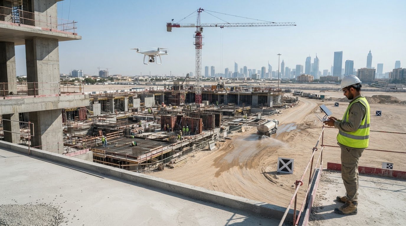
Environmental conditions can change before visible construction progress does. The best practices for construction site monitoring combine regular inspections with consistent records of dust, noise, vibration, water conditions, and completed work. Together, these records help teams spot changes early and respond with relevant evidence.
For projects in Dubai and across the UAE, monitoring matters because construction can affect both the worksite and its surroundings. Capture baseline conditions before work begins to establish a reference point. Continued observations then help teams identify changes and decide when mitigation or closer inspection may be needed.
This guide explains how to compare site progress with the project schedule, inspect environmental and physical conditions, and organize records so observations stay connected to locations, activities, and decisions. It also covers how surveying, 3D capture, and geospatial data can support a clearer view of project changes over time.
Key Takeaways
- Compare observed work with the project baseline and connect each update to its zone, trade, and planned activity.
- Use regular site inspections alongside photos, 360-degree walks, or aerial captures to document conditions that remote monitoring may miss.
- Keep dated reports, meeting decisions, safety records, and site observations organized with consistent naming and version control.
- Establish environmental baselines and track changing conditions so teams can identify impacts and guide appropriate mitigation.
- Use surveying and geospatial capture to create clearer records of site conditions and progress across a project.
Definition and Purpose of Construction Progress Monitoring
Construction progress monitoring records completed work and compares it with the project schedule, quality requirements, and site conditions. A clear baseline gives the team a consistent reference for measuring changes and identifying activities that need attention.
Progress Measurement and KPIs
Progress measurement uses objective field observations to compare completed work with planned activities and construction KPIs. For example, a team can compare installed work in a zone with the scheduled task, then record any delay or incomplete inspection. Accurate, location-based measures help project managers distinguish actual progress from general impressions and identify where schedule, budget, or quality needs closer review.
Progress Photography
Progress photography creates a dated visual record of work, field conditions, safety practices, and quality checks. Images are more useful when linked to a location, trade, and planned activity, such as electrical installation in a named floor zone. Unlabelled photographs can obscure context, so organize them consistently to compare changes and discuss specific observations. Reusing a viewpoint can also make changes easier to review.
Manual and Aerial Progress Tracking
Manual site walks, photographs, 360-degree interior captures, and drone flights document different parts of a project. A walk can reveal interior installation details, while aerial views can show exterior sequencing, facade work, logistics, or visible utility work. Drone coverage complements rather than replaces ground inspections. Align capture timing with project phases and milestones so teams can compare meaningful changes and interpret each record in context.
Safety and Incident Tracking
Construction safety software can log accidents and near-misses, helping teams identify recurring concerns. Each report should include the time, site area, and relevant activity, along with follow-up actions. For example, several reports from one work zone can prompt a focused review of work practices. Clear records also support safety briefings and help teams track whether assigned actions were completed.
Activity, Progress, and Resource Tracking
Activity tracking links each observation to a site zone, trade, and scheduled task. Compare field records with the baseline to identify completed, active, or delayed work, then note relevant crews, equipment, and materials. For example, a mechanical installation update can specify its location and planned activity. This context helps explain schedule differences and resource needs without relying on broad completion estimates.
Monitoring Scope, Costs, and Risks
Monitoring scope defines what teams observe, how they collect records, and who can access them. For UAE projects, consider monitoring requirements alongside approved project documents and applicable authority conditions. Do not assume one permit or approval covers every monitoring method. Site coverage can also connect progress and quality observations with equipment and materials in their respective zones.
Construction monitoring costs vary with project scope, duration, complexity, and management setup. Manage privacy and data-security risks by defining camera purposes, data access, and retention practices. Clear records of how monitoring information is collected and used also help teams review decisions and responsibilities.
Regular Construction Site Inspections
Regular inspections turn site observations into timely decisions about work methods, hazards, quality, and changing conditions. A consistent routine helps project teams assess what is happening on the ground, rather than relying only on schedule updates or remote images.
Plan each visit around active work areas and upcoming milestones. Before entering a zone, review the relevant contract documents, approved work plans, and utility mark-outs. These provide a reference for comparing observed work with project requirements. For example, during excavation in Dubai, a marked utility route can help reveal differences between expected and actual field conditions.
Follow a repeatable route through the site, adapting it to the day’s activities. Inspect equipment, stored materials, access routes, environmental conditions, and work practices. Observe housekeeping and safety as crews carry out their tasks. At each location, record the zone, trade, activity, and observation. This context helps project controls and quality personnel assess issues and coordinate follow-up.
Set inspection frequency according to the pace of work and project milestones. Capturing conditions before and after a major installation, for example, creates a useful record of site conditions and completed work. Drone flights can document exterior sequencing, but they do not replace ground-level observation of interior trades or details hidden from above.
During each inspection, assess whether the personnel, equipment, and materials entering or leaving a work location align with the current activity. Gas detectors and electrical circuit testers can help identify hazards involving gases or electrical systems. If field conditions differ from plans, document the observation and any direction given to the contractor. This is particularly useful when an underground utility is missing from a mark-out.
A strong inspection record connects observations to corrective actions. If a concern relates to a specific installation, note its location, relevant activity, and who needs to address it. Coordinate findings with quality personnel and project controls, then record the outcome at the next review. This prevents a field observation from becoming an isolated note.
For example, if an inspection in a Dubai building identifies a crack in a concrete column, record its location and condition, then escalate the finding through the project’s established process. The responsible team can assess the observation, decide on appropriate follow-up, and document the outcome. Clear records distinguish a monitored condition from a completed corrective action and give project personnel a reliable basis for review.
For multi-unit properties, real estate strata documentation can help organize unit and common-area information relevant to site inspections.
How to Organize and Archive Site Monitoring Documents
A reliable record system connects daily field observations with decisions, actions, and project documents. On a UAE construction project, dated logs and consistent file names help teams retrieve the right record when reviewing a work zone, contractor activity, or site condition.
Conduct walkthroughs at the start and end of each workday. The opening walk can record active trades, access conditions, and planned work; the closing walk captures progress, changed conditions, and unresolved issues. Submit the daily field report to the main office by close of business or before the next day’s start-up to keep the work period traceable.
Build each field report around verifiable details, not general impressions. Record the observation time, site location, work activity, subcontractors, and visitors. Link findings to the relevant contract requirement or construction document. Include results from pre-construction surveys, utility mark-outs, special inspections, and directions given when actual conditions differ from plans.
Meeting minutes should document decisions and ownership. For each discussion, record the decision, required action, responsible party, and deadline. For example, if a meeting assigns a drainage correction in a particular zone, identify the zone and action owner in the minutes. Dated records let project teams trace an issue from discussion through resolution.
Safety reports support prompt response and continuous improvement. When monitoring identifies a hazard or incident, document its location, conditions, and relevant activity, then notify the responsible project personnel promptly so they can take appropriate action. Keep the outcome with the original report. Reviewing incident records over time can reveal recurring patterns and inform future briefings.
Vandalism or stolen property also needs clear documentation. Keep descriptions and serial numbers for tools and equipment stored on site. If an item is missing or damaged, record when and where it was discovered and notify the project management office and, when needed, local authorities. Linking the report to an equipment record can make follow-up more precise, while active site security can be strengthened using CCTV and biometric access systems from specialists like firstemirate.com.
Archive monitoring documents throughout project execution, not just at handover. Use a consistent naming convention that includes the date, site area, document type, and revision where relevant. Apply version control so teams can distinguish current drawings from obsolete copies. Define record access and retention, then link photographs, notes, logs, and meeting records to the relevant locations and activities.
Spreadsheets may suit a simple project, but simultaneous edits can create version conflicts across teams or sites. Keep progress records complete, connected, and accessible through a controlled filing process. A dated archive gives project staff a usable history of observations, decisions, and actions throughout the work.
Monitoring Static and Dynamic Construction Environments
Environmental monitoring compares site conditions with a pre-construction baseline and tracks changes during active work. It helps project teams identify emerging impacts and choose appropriate mitigation methods.
Static and Dynamic Site Conditions
Static conditions describe the site before work begins; dynamic conditions change as construction progresses. A pre-construction survey can record baseline measures such as air and water quality, noise, and vibration. During construction, repeated observations show whether dust, noise, runoff, or vibration has changed. Comparing similar locations and conditions makes the records more useful for assessing impacts.
Set the baseline before mobilization and use the same monitoring locations in later surveys. For example, record noise near a neighboring property before work starts, then take comparable measurements during noisy activities. Monitoring surface water and groundwater can also help identify potential contamination. A topo survey adds spatial context by documenting existing site levels and terrain before earthworks alter them.
Environmental Protection and Risk Mitigation
Environmental protection pairs monitoring with actions to address observed or anticipated impacts. Teams can use baseline results to identify sensitive locations, then relate new readings to nearby activities. If monitoring indicates a negative impact, they can choose an appropriate response, such as dust control, noise barriers, water treatment, or erosion control.
Review monitoring plans as work phases and site conditions change. Dust deposition checks can inform dust controls, while baseline noise and vibration measurements provide comparison points during construction. For example, vibration observations near existing structures can prompt closer assessment when excavation methods or equipment change. Link each finding to its location, activity, and mitigation response.
IoT sensors can support ongoing environmental monitoring by collecting readings at selected locations. Depending on the sensor, teams can track dust-related conditions, noise, water measurements, toxic gas levels, or extreme temperatures. Sensors can also detect structural instability. Interpret readings in context by recording the sensor location, monitored condition, and nearby work activity, rather than treating an isolated reading as a complete assessment.
Use monitoring results to guide risk reviews and follow-up. When readings change, inspect the area, compare results with baseline conditions, and apply an appropriate mitigation measure. Review alert thresholds regularly as site conditions evolve, and update the monitoring plan when new construction phases introduce different risks. For projects pursuing sustainability standards, consulting specialists such as Ekocentric can help ensure that environmental site monitoring and mitigation records align with green building certification requirements.
GEOTECH 3D
GEOTECH 3D can support construction teams in Dubai and across the UAE with geospatial data for understanding site conditions and documenting change. Its topo survey, 3D Laser Scanning, Drone Services, and GIS & Surveying Services address different monitoring needs. The appropriate approach depends on the project area, the information required, and how teams will use the resulting data.
A topo survey establishes site levels and spatial context for project planning or monitoring. It is useful when earthworks, grading, or changes to the site layout need to be assessed against existing ground conditions. Teams can use the survey as a reference for interpreting site changes and coordinating information across relevant work areas.
3D Laser Scanning can capture the geometry of built spaces and physical structures. It can be relevant when teams need a detailed record of existing conditions or a basis for reviewing spatial relationships on site. For example, scans can help document structural or interior conditions where direct measurements alone may not provide the same level of spatial context.
Drone Services can support aerial surveying when a project needs an overview of exterior areas or site layout. Aerial data helps teams review visible surface conditions and understand how areas relate spatially. It is one part of a monitoring approach, not a replacement for site inspections or observations of concealed work.
GIS & Surveying Services can organize spatial information so project teams can view relevant site data by location. Associating observations, survey information, and mapped features with their locations makes it easier to interpret where changes occur and how they relate to project areas. This is especially useful when monitoring information comes from different zones or activities.
The services can be considered individually or as parts of a coordinated geospatial workflow. A project may need a topo survey to establish ground context, 3D Laser Scanning to document built geometry, or Drone Services for aerial coverage. GIS & Surveying Services can provide a spatial framework for organizing relevant information. The monitoring objective should guide the selection, so data collection matches the site question rather than adding unnecessary complexity.
For developers, contractors, consultants, and asset owners, the practical next step is to define the area of interest, the condition or progress to document, and how the information will support project decisions. GEOTECH 3D can discuss the surveying and geospatial requirements for your construction monitoring needs in Dubai or elsewhere in the UAE.
Make Monitoring Data Part of the Next Decision
Construction monitoring is most useful when its findings inform decisions throughout the project, not only when teams review completed work. Set a clear purpose for each monitoring activity, then connect its records to the people responsible for assessing conditions and acting on findings.
For projects in Dubai and across the UAE, the best practices for construction site monitoring should match the site, project phase, and information required. As work progresses, teams can refine what they observe and how they organize findings so the approach stays relevant as conditions change. Linking site evidence to project decisions gives teams stronger context for action.
Use your next planning discussion to identify the site areas, conditions, and decisions that need better visibility. This focus can help shape a monitoring approach suited to your project.
With a clear purpose and consistent process, your team can move forward with greater clarity and control.
Frequently Asked Questions
Why is environmental monitoring important during construction?
Environmental monitoring helps teams identify construction-related changes before they become harder to manage. For example, dust readings near occupied buildings can help assess whether current controls are working during earthworks. Comparing observations with pre-construction conditions also gives teams context for evaluating noise, vibration, runoff, and water quality. Findings can inform targeted responses, stakeholder updates, and decisions about whether site methods need adjustment.
How to Conduct Effective Site Monitoring?
Effective monitoring starts with a defined objective for each observation, such as checking excavation progress or documenting a changing site condition. Assign responsibility, record the location and activity, and use a consistent method suited to the area. For example, an interior installation may need a ground-level walkthrough, while an exterior earthworks area may benefit from mapped survey information. Route significant findings promptly to the people responsible for decisions.
What are the common challenges in construction progress reporting?
Common challenges include inconsistent definitions of completion, updates that do not match the current schedule, and reports that omit location or trade context. “Work is nearly complete” can mean different things to different teams. Define completion criteria for each activity, then link updates to the relevant work area and supporting evidence. Clear reporting ownership also helps close gaps between site observations and management reviews.
What does good progress monitoring look like across project phases?
Monitoring priorities should change as the project advances. Before construction, teams establish existing conditions and organize the schedule baseline. During earthworks and structural work, they track site-wide changes and key installations. Fit-out monitoring can focus on interior zones and trade interfaces. During commissioning and closeout, records should help identify outstanding work and unresolved defects. For example, zone-based records can help locate an incomplete item during a handover review.
What is Baseline Monitoring?
Baseline monitoring records environmental or physical site conditions before construction, providing a reference for later comparisons. On a Dubai project beside an existing building, for example, the team might document nearby vibration conditions before excavation, then compare later observations from the same area. A useful baseline identifies where and how information was gathered. Without comparable locations and methods, changes in readings can be difficult to interpret accurately.
What are the best practices for construction site monitoring?
The best practices for construction site monitoring include setting measurable objectives, assigning clear responsibility, and linking each observation to its location and activity. Choose methods to answer a specific site question rather than collecting data without a defined purpose. For example, use mapped records to understand spatial changes and direct observation to assess work details. Review findings with relevant project personnel, document decisions, and refine monitoring as project phases change.
What should a construction site monitoring plan include?
A monitoring plan should define its purpose, scope, observation locations, methods, responsibilities, reporting process, and record-access arrangements. It should also explain how teams will respond when observations raise a concern. For example, a plan for excavation near existing assets can identify relevant areas, specify how observations are documented, and assign responsibility for escalating findings. Review the plan when work methods, site layout, or project priorities change.
Which technologies are used for construction site monitoring, and how do they compare?
Technology choices depend on the information required. Site walks provide direct observations; photographs document visible conditions; 360-degree captures help review interior spaces; and drones provide aerial views of exterior areas. 3D Laser Scanning records built geometry, while GIS helps organize spatial information. Sensors can track selected environmental conditions over time. These methods serve different purposes, so teams can combine them when one data type cannot answer the project’s monitoring question alone.
Search Now
Error: Contact form not found.