

Our Services
Digital Twin for Construction: 2026 UAE Strategic Guide
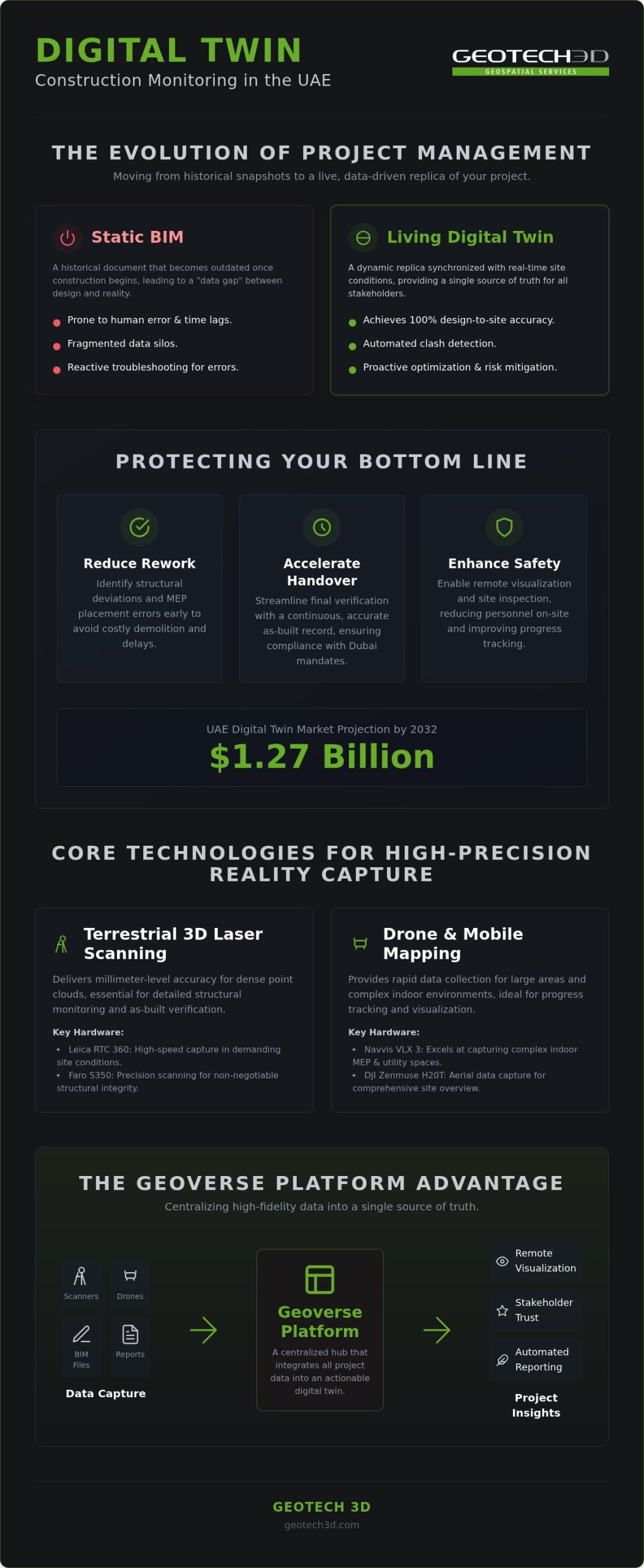
With the UAE digital twin market projected to reach a valuation of up to $1.27 billion by 2032, the construction industry’s transition toward automated precision is no longer optional. You’ve likely felt the pressure of Dubai’s high-speed infrastructure projects where a small discrepancy between design intent and site reality can lead to weeks of costly rework. Fragmented data silos between site teams and consultants often hide these errors until it’s too late. Implementing a sophisticated digital twin for construction monitoring provides the real-time clarity needed to keep complex projects on track and within budget.
This 2026 strategic guide explores how to leverage the Geoverse Platform and high-precision tools like the Leica RTC 360 to ensure 100% design-to-site accuracy. We’ll show you how to eliminate delays, enhance safety through remote visualization, and automate progress tracking. You’ll learn to integrate reality capture data from the Navvis VLX 3 and DJI Zenmuse H20T into a single source of truth for all stakeholders. By the end of this article, you’ll understand how to transform your project data into a live risk-mitigation engine that protects your bottom line and ensures project integrity.
Key Takeaways
- Transition from static BIM to “living” digital twins to achieve 100% design-to-site accuracy on complex UAE infrastructure projects.
- Leverage a digital twin for construction monitoring to identify discrepancies early, significantly reducing rework and project delays.
- Evaluate the strategic use of terrestrial 3D laser scanning versus drone surveys to capture high-fidelity data for structural monitoring.
- Centralize project data within the Geoverse Platform to create a single source of truth that bridges the gap between site teams and consultants.
- Enhance site safety and progress tracking through remote visualization, ensuring compliance with Dubai’s evolving digital construction mandates.
The Evolution of Construction Monitoring: From Static BIM to Living Digital Twins
Traditional construction management often relies on snapshots in time. While Building Information Modeling (BIM) revolutionized the design phase, those models frequently become stagnant once ground is broken. In the context of Dubai’s rapid urban expansion, a static 3D model quickly turns into a historical document rather than an active management tool. A Digital Twin, however, functions as a dynamic, data-driven replica of your physical asset. It doesn’t just show what was planned; it reflects what exists on the ground at this exact moment.
This shift from static to living entities is powered by continuous data loops. By integrating high-precision reality capture from 3D laser scanning and drone surveys, project managers move from reactive troubleshooting to proactive optimization. This technology closes the “data gap” that typically exists between site conditions and office-based design teams. It ensures that every stakeholder, from the site engineer to the consultant, operates from a single source of truth hosted on platforms like GEOTECH 3D’s Geoverse Platform.
Bridging the Gap Between Design Intent and Site Reality
Traditional monitoring depends heavily on manual inspections and paper-based reporting. These methods are prone to human error and create significant time lags. By the time a discrepancy is noted, it might already be buried under layers of concrete or structural steel. Digital twins provide an immediate as-built record that can be overlaid directly against the as-designed plans. A digital twin for construction monitoring is a synchronized digital record that reflects real-time site changes. This level of transparency allows for automated clash detection, ensuring that site work never deviates from the original engineering intent.
The ROI of Real-Time Monitoring in the UAE
The financial implications of precision monitoring are substantial for major Dubai infrastructure projects. By identifying structural deviations before they escalate into major rework, contractors protect their margins and avoid the heavy penalties associated with project delays. Moving from manual checks to automated digital workflows transforms the project’s bottom line.
- Reduced Rework: Detect discrepancies in slab levels or MEP placement early to avoid costly demolition.
- Accelerated Handover: Streamline the final verification process with a continuous as-built record.
- Stakeholder Transparency: Enhance trust through a shared digital environment where progress is verifiable.
As Dubai Municipality continues to enforce sophisticated BIM mandates, adopting a digital twin for construction monitoring ensures your project remains compliant while maximizing operational efficiency. It’s about moving beyond just building to managing the entire lifecycle of an asset with total confidence and precision.
Core Technologies for High-Precision Reality Capture
Reliable digital twin for construction monitoring starts with high-fidelity data acquisition. In the UAE, this process is frequently challenged by extreme ambient temperatures and airborne dust, which can compromise sensitive optical sensors. Utilizing robust hardware like the Leica RTC 360 ensures that reality capture remains precise even in these demanding site conditions. This technical rigor reflects the findings of the U.S. GAO on Digital Twin Technology, which highlights that the utility of a twin is directly tied to the quality and frequency of its data updates. Without millimeter-level accuracy at the source, the digital replica cannot serve as a dependable tool for risk mitigation.
Advanced Scanning Hardware: Faro, Leica, and Navvis
We utilize the Faro S350 and Leica RTC 360 for high-speed capture where structural precision is non-negotiable. These terrestrial scanners provide the dense point clouds required for detailed structural monitoring. For rapid indoor data collection, the Navvis VLX 3 excels at capturing complex environments, including difficult over-ceiling utility spaces that are often overlooked. A standout feature for project stakeholders is the “Bubble view.” This provides an immersive, panoramic walkthrough of the site, allowing remote teams in Dubai or international consultants to inspect progress without physical site visits. This transparency builds trust and ensures that site conditions are visible to every decision-maker.
From Raw Point Clouds to BIM-Ready Models
Converting raw point clouds into actionable models is where raw data becomes strategic intelligence. The Scan-to-BIM process is essential for creating a functional digital twin for construction monitoring, as it translates billions of points into structured elements. Maintaining data integrity during this transition is vital to ensure the digital replica remains 100% accurate to the site. Our workflows ensure full compatibility with industry-standard CAD packages, allowing UAE engineering firms to integrate these models into their existing project management systems. Exploring professional 3D Laser Scanning is often the first step in bridging this gap between raw site data and an actionable digital environment.
Beyond stationary scans, mobile LiDAR systems allow for the rapid modeling of large-scale infrastructure and city-scale assets. When integrated with IoT sensors, these models provide real-time telemetry, including environmental data and structural health indicators. For example, using the DJI Zenmuse H20T enables thermal monitoring of critical components, adding a layer of safety that traditional inspections miss. This holistic approach ensures that every facet of a Dubai project is documented with scientific precision, moving the project from simple observation to advanced, data-driven management.
Comparing Data Capture Methods: Drone Surveys vs. Terrestrial Scanning
Choosing the right data acquisition method is a strategic decision that defines the utility of your digital twin for construction monitoring. While the previous section detailed specific hardware, this framework helps you decide when to deploy each asset. Aerial drone surveys and terrestrial laser scanning aren’t competitors; they’re complementary tools. Drones offer the speed and scale required for topographic mapping and site-wide progress tracking across Dubai’s expansive infrastructure projects. Conversely, terrestrial scanning provides the sub-millimeter precision necessary for complex MEP installations and verifying structural integrity during internal fit-outs.
Integrated data sets create a more robust model. According to the NSF on Digital Twin Impacts, these virtual models are essential for managing complex systems and making smarter, risk-aware decisions. In the UAE’s high-velocity market, a hybrid approach often yields the best results. By combining aerial perspectives of a building’s shell with dense point clouds of its interior, you create a comprehensive digital record. This ensures that every stakeholder, from the site office to the consultant’s headquarters, views the same reality. Utilizing professional Drone Services alongside ground-based capture eliminates the blind spots that lead to costly rework.
UAV Payloads for Construction Inspection
The DJI Zenmuse H20T multi-sensor payload is a vital tool for inspecting Dubai’s high-rise developments. It allows teams to conduct high-resolution façade inspections without the safety risks and costs of manual rope access. Thermal monitoring capabilities help identify insulation leaks, moisture ingress, or electrical anomalies that are invisible to the naked eye. This proactive inspection layer ensures that the building’s thermal performance meets the UAE’s stringent sustainability and energy codes before handover.
Performance Metrics: Accuracy, Speed, and Scale
Speed and accuracy often sit at opposite ends of the operational spectrum. Terrestrial scanners deliver sub-millimeter precision but require more time to navigate between scan stations. Drone surveys cover hectares in minutes but typically offer centimeter-level accuracy. Operational constraints in the UAE also play a role; high winds and extreme summer temperatures can limit drone flight windows. Additionally, strict adherence to DCAA and GCAA regulations for UAE airspace is a non-negotiable requirement for any site operation. A cost-benefit analysis usually shows that milestone-based capture sessions provide the optimal balance for a digital twin for construction monitoring. This rhythm ensures the model remains a living entity that accurately reflects site progress without exceeding the project’s data management budget.
Implementation Framework: Monitoring Progress with the Geoverse Platform
Capturing high-fidelity data is only the first step toward project success. To derive actionable intelligence, that data must live within a centralized hub. The Geoverse Platform serves as this essential single source of truth, consolidating information from diverse reality capture sources into a unified environment. By establishing a robust implementation framework, you ensure that every stakeholder, from the site engineer in Dubai to the consultant in Abu Dhabi, accesses identical, real-time information. This centralized approach is what makes a digital twin for construction monitoring a true risk-mitigation engine rather than just a visual aid.
Integrating multi-source geospatial data allows for sophisticated spatial analysis that traditional methods can’t match. For large-scale UAE infrastructure projects, the platform automates the tracking of volumetric changes and material stockpiles. Instead of relying on manual estimates, project managers receive precise calculations derived from the latest point cloud data. You can set up automated reporting cycles that flag deviations from the project schedule immediately. This ensures that progress isn’t just observed but is scientifically measured against your original milestones.
The Role of the Geoverse Platform in Construction
The Geoverse Platform isn’t limited to individual project sites; it enables city-scale modeling and smart city management. This capability is vital for developers aligning with the Dubai 2040 Urban Master Plan. It allows for real-time progress monitoring where you track site evolution against the master project schedule. If your focus extends beyond the construction phase, our Digital Twin for Asset Lifecycle guide provides long-term management strategies for the operational phase. It’s about building a digital thread that follows the asset from the first stone to daily operations.
Enhancing Safety and Compliance via Digital Twins
Safety is a non-negotiable priority on any UAE construction site. A digital twin for construction monitoring provides a comprehensive digital record that simplifies site safety audits and confined space inspections. You can visualize high-risk areas remotely, reducing the need for personnel to enter hazardous environments. Monitoring structural health and stability during critical construction phases becomes a data-driven process. This level of documentation ensures total compliance with UAE construction safety regulations, providing an irrefutable as-built record that protects both the workforce and the project’s legal standing.
The GEOTECH 3D Advantage: Precision Solutions for UAE Construction
GEOTECH 3D stands as a cornerstone of precision in the UAE’s surveying and geospatial landscape. We specialize in high-precision data acquisition for the region’s most complex and ambitious developments. Our team understands that a digital twin for construction monitoring is only as effective as the underlying data used to build it. We provide end-to-end solutions that span the entire project timeline, from the initial topo survey to the delivery of sophisticated Scan-to-BIM models. This comprehensive approach ensures that every millimeter of the physical site is captured and accounted for in the digital environment. We maintain a rigorous commitment to safety standards and the aggressive project schedules that characterize construction in the Middle East.
Our expertise lies in delivering BIM-ready data that integrates seamlessly with your existing client workflows. We don’t just provide raw point clouds; we deliver structured, actionable intelligence that engineers and project managers can use immediately. By bridging the gap between reality capture and design software, we help you maintain 100% accuracy throughout the build. This dedication to technical integrity makes us a trusted partner for developers who cannot afford the risks of data discrepancies or site rework.
Local Expertise in Dubai and Abu Dhabi
Our team brings decades of collective experience serving the UAE’s architecture and engineering sectors. We aren’t just technical providers; we’re a local partner professionally registered and licensed to operate across all seven Emirates. This localized presence allows us to navigate the specific regulatory requirements of Dubai Municipality and other local authorities with total confidence. You can contact our Dubai Office for site-specific digital twin consultations tailored to your project’s unique requirements. We act as a faithful guide through the complexities of reality capture, ensuring your data meets all local compliance standards.
A Partner for the Entire Asset Lifecycle
The value of our services extends far beyond the construction phase. We assist clients in transitioning from active digital twin for construction monitoring to long-term infrastructure asset management. This continuity ensures that the high-fidelity data captured during the build continues to pay dividends throughout the building’s operational life. Whether you’re supporting heritage preservation, managing real estate strata, or ensuring sustainable project outcomes through BIM optimization, our accurate digital records provide the necessary foundation. We’re committed to the long-term integrity of your assets, providing the precision required to manage them with total certainty.
Future-Proofing Your UAE Construction Strategy
Adopting a sophisticated digital twin for construction monitoring represents a fundamental shift from reactive site management to proactive, data-driven precision. By integrating high-fidelity reality capture from the Leica RTC 360 and Navvis VLX 3 into the Geoverse Platform, you establish a single source of truth that ensures 100% design-to-site accuracy. This approach doesn’t just eliminate costly rework; it builds a foundation for long-term asset management and total compliance with Dubai’s rigorous construction and safety standards. Every data point captured today serves as a vital record for the entire lifecycle of your asset, ensuring that your project remains resilient and efficient well beyond the handover phase.
The transition to living digital entities is the key to navigating the complexity of modern infrastructure projects with total confidence. We’re ready to help you bridge the gap between design intent and site reality. Let’s work together to ensure your next project is delivered with the precision and integrity it deserves.
Frequently Asked Questions
How often should a digital twin be updated during the construction phase?
The update frequency for a digital twin for construction monitoring usually aligns with your project’s specific milestones and reporting cycles. For high-speed Dubai infrastructure projects, weekly or bi-weekly updates are recommended to capture rapid site evolution. Major structural events, such as floor slab casting or MEP installation, require immediate reality capture sessions. This ensures the digital replica remains a living entity that accurately reflects the current site status for all stakeholders.
What is the difference between a 3D BIM model and a digital twin for construction?
A 3D BIM model primarily represents the as-designed intent of a project. In contrast, a digital twin for construction monitoring is a dynamic replica that incorporates real-time as-built data from the site. While BIM provides the framework, the digital twin uses continuous data loops from laser scanning and drones to reflect actual conditions. This allows project managers to identify discrepancies between the original design and the physical construction as they happen.
Can digital twins help in reducing construction rework costs in Dubai?
Yes, a digital twin for construction monitoring significantly reduces rework costs by enabling automated clash detection between design models and site conditions. In Dubai’s fast-paced sector, identifying a misplaced structural element or MEP pipe early prevents expensive demolition. By catching these errors before they’re permanent, contractors protect their profit margins. Accurate documentation also streamlines the handover process, avoiding the delays that often lead to heavy financial penalties on large-scale UAE developments.
What hardware is best for creating a digital twin of a complex MEP system?
For complex MEP systems, we recommend using high-precision terrestrial scanners like the Leica RTC 360 alongside mobile mappers like the Navvis VLX 3. The Leica RTC 360 provides the sub-millimeter accuracy needed for dense pipe networks. The Navvis VLX 3 is particularly effective for indoor and over-ceiling inspections, allowing our teams to capture utility data in confined spaces that are difficult to reach with traditional tripods. This ensures no detail is missed during the build.
How does GEOTECH 3D ensure the accuracy of its reality capture data?
GEOTECH 3D ensures accuracy by utilizing industry-leading hardware and a rigorous data processing workflow. We use the Faro S350 and Leica RTC 360 to achieve millimeter-level precision in every scan. Our team’s decades of experience in the UAE allow us to manage complex environmental factors like heat and dust that can affect sensor performance. Every point cloud is professionally registered and verified before it’s integrated into the Geoverse Platform for unified spatial analysis.
Is a digital twin suitable for small-scale construction projects in the UAE?
While often associated with megaprojects, digital twins are highly beneficial for small-scale UAE projects with high complexity. Luxury villa renovations or specialized brownfield fit-outs in Dubai benefit from the same as-built accuracy as large towers. Reducing rework on a smaller project can have an even more significant impact on the overall percentage of profit. Any project where design-to-site accuracy is critical can leverage this technology to ensure a successful and compliant outcome.
What software is required to view and manage a construction digital twin?
The Geoverse Platform is our primary solution for viewing and managing city-scale or project-scale digital twins. It serves as a unified hub where stakeholders can access spatial analysis tools and immersive Bubble views of the site. Additionally, our data is delivered in formats that integrate seamlessly with industry-standard CAD and BIM software. This ensures your engineering team can continue working in their preferred environment while benefiting from high-fidelity reality capture data throughout the project.
How do drone surveys integrate into a larger digital twin framework?
Drone surveys provide the essential aerial context and large-scale topographic data that terrestrial scans might miss. Using payloads like the DJI Zenmuse H20T, we capture high-resolution visual and thermal data of façades and rooftops. This aerial information is then merged with ground-based laser scanning data within the Geoverse Platform. This hybrid approach creates a comprehensive record of the entire asset, from the underground utilities to the highest structural point of a Dubai skyscraper.
With the UAE digital twin market projected to reach a valuation of up to $1.27 billion by 2032, the construction industry’s transition toward automated precision is no longer optional. You’ve likely felt the pressure of Dubai’s high-speed infrastructure projects where a small discrepancy between design intent and site reality can lead to weeks of costly rework. Fragmented data silos between site teams and consultants often hide these errors until it’s too late. Implementing a sophisticated digital twin for construction monitoring provides the real-time clarity needed to keep complex projects on track and within budget.
This 2026 strategic guide explores how to leverage the Geoverse Platform and high-precision tools like the Leica RTC 360 to ensure 100% design-to-site accuracy. We’ll show you how to eliminate delays, enhance safety through remote visualization, and automate progress tracking. You’ll learn to integrate reality capture data from the Navvis VLX 3 and DJI Zenmuse H20T into a single source of truth for all stakeholders. By the end of this article, you’ll understand how to transform your project data into a live risk-mitigation engine that protects your bottom line and ensures project integrity.
Key Takeaways
- Transition from static BIM to “living” digital twins to achieve 100% design-to-site accuracy on complex UAE infrastructure projects.
- Leverage a digital twin for construction monitoring to identify discrepancies early, significantly reducing rework and project delays.
- Evaluate the strategic use of terrestrial 3D laser scanning versus drone surveys to capture high-fidelity data for structural monitoring.
- Centralize project data within the Geoverse Platform to create a single source of truth that bridges the gap between site teams and consultants.
- Enhance site safety and progress tracking through remote visualization, ensuring compliance with Dubai’s evolving digital construction mandates.
The Evolution of Construction Monitoring: From Static BIM to Living Digital Twins
Traditional construction management often relies on snapshots in time. While Building Information Modeling (BIM) revolutionized the design phase, those models frequently become stagnant once ground is broken. In the context of Dubai’s rapid urban expansion, a static 3D model quickly turns into a historical document rather than an active management tool. A Digital Twin, however, functions as a dynamic, data-driven replica of your physical asset. It doesn’t just show what was planned; it reflects what exists on the ground at this exact moment.
This shift from static to living entities is powered by continuous data loops. By integrating high-precision reality capture from 3D laser scanning and drone surveys, project managers move from reactive troubleshooting to proactive optimization. This technology closes the “data gap” that typically exists between site conditions and office-based design teams. It ensures that every stakeholder, from the site engineer to the consultant, operates from a single source of truth hosted on platforms like GEOTECH 3D’s Geoverse Platform.
Bridging the Gap Between Design Intent and Site Reality
Traditional monitoring depends heavily on manual inspections and paper-based reporting. These methods are prone to human error and create significant time lags. By the time a discrepancy is noted, it might already be buried under layers of concrete or structural steel. Digital twins provide an immediate as-built record that can be overlaid directly against the as-designed plans. A digital twin for construction monitoring is a synchronized digital record that reflects real-time site changes. This level of transparency allows for automated clash detection, ensuring that site work never deviates from the original engineering intent.
The ROI of Real-Time Monitoring in the UAE
The financial implications of precision monitoring are substantial for major Dubai infrastructure projects. By identifying structural deviations before they escalate into major rework, contractors protect their margins and avoid the heavy penalties associated with project delays. Moving from manual checks to automated digital workflows transforms the project’s bottom line.
- Reduced Rework: Detect discrepancies in slab levels or MEP placement early to avoid costly demolition.
- Accelerated Handover: Streamline the final verification process with a continuous as-built record.
- Stakeholder Transparency: Enhance trust through a shared digital environment where progress is verifiable.
As Dubai Municipality continues to enforce sophisticated BIM mandates, adopting a digital twin for construction monitoring ensures your project remains compliant while maximizing operational efficiency. It’s about moving beyond just building to managing the entire lifecycle of an asset with total confidence and precision.
Core Technologies for High-Precision Reality Capture
Reliable digital twin for construction monitoring starts with high-fidelity data acquisition. In the UAE, this process is frequently challenged by extreme ambient temperatures and airborne dust, which can compromise sensitive optical sensors. Utilizing robust hardware like the Leica RTC 360 ensures that reality capture remains precise even in these demanding site conditions. This technical rigor reflects the findings of the U.S. GAO on Digital Twin Technology, which highlights that the utility of a twin is directly tied to the quality and frequency of its data updates. Without millimeter-level accuracy at the source, the digital replica cannot serve as a dependable tool for risk mitigation.
Advanced Scanning Hardware: Faro, Leica, and Navvis
We utilize the Faro S350 and Leica RTC 360 for high-speed capture where structural precision is non-negotiable. These terrestrial scanners provide the dense point clouds required for detailed structural monitoring. For rapid indoor data collection, the Navvis VLX 3 excels at capturing complex environments, including difficult over-ceiling utility spaces that are often overlooked. A standout feature for project stakeholders is the “Bubble view.” This provides an immersive, panoramic walkthrough of the site, allowing remote teams in Dubai or international consultants to inspect progress without physical site visits. This transparency builds trust and ensures that site conditions are visible to every decision-maker.
From Raw Point Clouds to BIM-Ready Models
Converting raw point clouds into actionable models is where raw data becomes strategic intelligence. The Scan-to-BIM process is essential for creating a functional digital twin for construction monitoring, as it translates billions of points into structured elements. Maintaining data integrity during this transition is vital to ensure the digital replica remains 100% accurate to the site. Our workflows ensure full compatibility with industry-standard CAD packages, allowing UAE engineering firms to integrate these models into their existing project management systems. Exploring professional 3D Laser Scanning is often the first step in bridging this gap between raw site data and an actionable digital environment.
Beyond stationary scans, mobile LiDAR systems allow for the rapid modeling of large-scale infrastructure and city-scale assets. When integrated with IoT sensors, these models provide real-time telemetry, including environmental data and structural health indicators. For example, using the DJI Zenmuse H20T enables thermal monitoring of critical components, adding a layer of safety that traditional inspections miss. This holistic approach ensures that every facet of a Dubai project is documented with scientific precision, moving the project from simple observation to advanced, data-driven management.
Comparing Data Capture Methods: Drone Surveys vs. Terrestrial Scanning
Choosing the right data acquisition method is a strategic decision that defines the utility of your digital twin for construction monitoring. While the previous section detailed specific hardware, this framework helps you decide when to deploy each asset. Aerial drone surveys and terrestrial laser scanning aren’t competitors; they’re complementary tools. Drones offer the speed and scale required for topographic mapping and site-wide progress tracking across Dubai’s expansive infrastructure projects. Conversely, terrestrial scanning provides the sub-millimeter precision necessary for complex MEP installations and verifying structural integrity during internal fit-outs.
Integrated data sets create a more robust model. According to the NSF on Digital Twin Impacts, these virtual models are essential for managing complex systems and making smarter, risk-aware decisions. In the UAE’s high-velocity market, a hybrid approach often yields the best results. By combining aerial perspectives of a building’s shell with dense point clouds of its interior, you create a comprehensive digital record. This ensures that every stakeholder, from the site office to the consultant’s headquarters, views the same reality. Utilizing professional Drone Services alongside ground-based capture eliminates the blind spots that lead to costly rework.
UAV Payloads for Construction Inspection
The DJI Zenmuse H20T multi-sensor payload is a vital tool for inspecting Dubai’s high-rise developments. It allows teams to conduct high-resolution façade inspections without the safety risks and costs of manual rope access. Thermal monitoring capabilities help identify insulation leaks, moisture ingress, or electrical anomalies that are invisible to the naked eye. This proactive inspection layer ensures that the building’s thermal performance meets the UAE’s stringent sustainability and energy codes before handover.
Performance Metrics: Accuracy, Speed, and Scale
Speed and accuracy often sit at opposite ends of the operational spectrum. Terrestrial scanners deliver sub-millimeter precision but require more time to navigate between scan stations. Drone surveys cover hectares in minutes but typically offer centimeter-level accuracy. Operational constraints in the UAE also play a role; high winds and extreme summer temperatures can limit drone flight windows. Additionally, strict adherence to DCAA and GCAA regulations for UAE airspace is a non-negotiable requirement for any site operation. A cost-benefit analysis usually shows that milestone-based capture sessions provide the optimal balance for a digital twin for construction monitoring. This rhythm ensures the model remains a living entity that accurately reflects site progress without exceeding the project’s data management budget.
Implementation Framework: Monitoring Progress with the Geoverse Platform
Capturing high-fidelity data is only the first step toward project success. To derive actionable intelligence, that data must live within a centralized hub. The Geoverse Platform serves as this essential single source of truth, consolidating information from diverse reality capture sources into a unified environment. By establishing a robust implementation framework, you ensure that every stakeholder, from the site engineer in Dubai to the consultant in Abu Dhabi, accesses identical, real-time information. This centralized approach is what makes a digital twin for construction monitoring a true risk-mitigation engine rather than just a visual aid.
Integrating multi-source geospatial data allows for sophisticated spatial analysis that traditional methods can’t match. For large-scale UAE infrastructure projects, the platform automates the tracking of volumetric changes and material stockpiles. Instead of relying on manual estimates, project managers receive precise calculations derived from the latest point cloud data. You can set up automated reporting cycles that flag deviations from the project schedule immediately. This ensures that progress isn’t just observed but is scientifically measured against your original milestones.
The Role of the Geoverse Platform in Construction
The Geoverse Platform isn’t limited to individual project sites; it enables city-scale modeling and smart city management. This capability is vital for developers aligning with the Dubai 2040 Urban Master Plan. It allows for real-time progress monitoring where you track site evolution against the master project schedule. If your focus extends beyond the construction phase, our Digital Twin for Asset Lifecycle guide provides long-term management strategies for the operational phase. It’s about building a digital thread that follows the asset from the first stone to daily operations.
Enhancing Safety and Compliance via Digital Twins
Safety is a non-negotiable priority on any UAE construction site. A digital twin for construction monitoring provides a comprehensive digital record that simplifies site safety audits and confined space inspections. You can visualize high-risk areas remotely, reducing the need for personnel to enter hazardous environments. Monitoring structural health and stability during critical construction phases becomes a data-driven process. This level of documentation ensures total compliance with UAE construction safety regulations, providing an irrefutable as-built record that protects both the workforce and the project’s legal standing.
The GEOTECH 3D Advantage: Precision Solutions for UAE Construction
GEOTECH 3D stands as a cornerstone of precision in the UAE’s surveying and geospatial landscape. We specialize in high-precision data acquisition for the region’s most complex and ambitious developments. Our team understands that a digital twin for construction monitoring is only as effective as the underlying data used to build it. We provide end-to-end solutions that span the entire project timeline, from the initial topo survey to the delivery of sophisticated Scan-to-BIM models. This comprehensive approach ensures that every millimeter of the physical site is captured and accounted for in the digital environment. We maintain a rigorous commitment to safety standards and the aggressive project schedules that characterize construction in the Middle East.
Our expertise lies in delivering BIM-ready data that integrates seamlessly with your existing client workflows. We don’t just provide raw point clouds; we deliver structured, actionable intelligence that engineers and project managers can use immediately. By bridging the gap between reality capture and design software, we help you maintain 100% accuracy throughout the build. This dedication to technical integrity makes us a trusted partner for developers who cannot afford the risks of data discrepancies or site rework.
Local Expertise in Dubai and Abu Dhabi
Our team brings decades of collective experience serving the UAE’s architecture and engineering sectors. We aren’t just technical providers; we’re a local partner professionally registered and licensed to operate across all seven Emirates. This localized presence allows us to navigate the specific regulatory requirements of Dubai Municipality and other local authorities with total confidence. You can contact our Dubai Office for site-specific digital twin consultations tailored to your project’s unique requirements. We act as a faithful guide through the complexities of reality capture, ensuring your data meets all local compliance standards.
A Partner for the Entire Asset Lifecycle
The value of our services extends far beyond the construction phase. We assist clients in transitioning from active digital twin for construction monitoring to long-term infrastructure asset management. This continuity ensures that the high-fidelity data captured during the build continues to pay dividends throughout the building’s operational life. Whether you’re supporting heritage preservation, managing real estate strata, or ensuring sustainable project outcomes through BIM optimization, our accurate digital records provide the necessary foundation. We’re committed to the long-term integrity of your assets, providing the precision required to manage them with total certainty.
Future-Proofing Your UAE Construction Strategy
Adopting a sophisticated digital twin for construction monitoring represents a fundamental shift from reactive site management to proactive, data-driven precision. By integrating high-fidelity reality capture from the Leica RTC 360 and Navvis VLX 3 into the Geoverse Platform, you establish a single source of truth that ensures 100% design-to-site accuracy. This approach doesn’t just eliminate costly rework; it builds a foundation for long-term asset management and total compliance with Dubai’s rigorous construction and safety standards. Every data point captured today serves as a vital record for the entire lifecycle of your asset, ensuring that your project remains resilient and efficient well beyond the handover phase.
The transition to living digital entities is the key to navigating the complexity of modern infrastructure projects with total confidence. We’re ready to help you bridge the gap between design intent and site reality. Let’s work together to ensure your next project is delivered with the precision and integrity it deserves.
Frequently Asked Questions
How often should a digital twin be updated during the construction phase?
The update frequency for a digital twin for construction monitoring usually aligns with your project’s specific milestones and reporting cycles. For high-speed Dubai infrastructure projects, weekly or bi-weekly updates are recommended to capture rapid site evolution. Major structural events, such as floor slab casting or MEP installation, require immediate reality capture sessions. This ensures the digital replica remains a living entity that accurately reflects the current site status for all stakeholders.
What is the difference between a 3D BIM model and a digital twin for construction?
A 3D BIM model primarily represents the as-designed intent of a project. In contrast, a digital twin for construction monitoring is a dynamic replica that incorporates real-time as-built data from the site. While BIM provides the framework, the digital twin uses continuous data loops from laser scanning and drones to reflect actual conditions. This allows project managers to identify discrepancies between the original design and the physical construction as they happen.
Can digital twins help in reducing construction rework costs in Dubai?
Yes, a digital twin for construction monitoring significantly reduces rework costs by enabling automated clash detection between design models and site conditions. In Dubai’s fast-paced sector, identifying a misplaced structural element or MEP pipe early prevents expensive demolition. By catching these errors before they’re permanent, contractors protect their profit margins. Accurate documentation also streamlines the handover process, avoiding the delays that often lead to heavy financial penalties on large-scale UAE developments.
What hardware is best for creating a digital twin of a complex MEP system?
For complex MEP systems, we recommend using high-precision terrestrial scanners like the Leica RTC 360 alongside mobile mappers like the Navvis VLX 3. The Leica RTC 360 provides the sub-millimeter accuracy needed for dense pipe networks. The Navvis VLX 3 is particularly effective for indoor and over-ceiling inspections, allowing our teams to capture utility data in confined spaces that are difficult to reach with traditional tripods. This ensures no detail is missed during the build.
How does GEOTECH 3D ensure the accuracy of its reality capture data?
GEOTECH 3D ensures accuracy by utilizing industry-leading hardware and a rigorous data processing workflow. We use the Faro S350 and Leica RTC 360 to achieve millimeter-level precision in every scan. Our team’s decades of experience in the UAE allow us to manage complex environmental factors like heat and dust that can affect sensor performance. Every point cloud is professionally registered and verified before it’s integrated into the Geoverse Platform for unified spatial analysis.
Is a digital twin suitable for small-scale construction projects in the UAE?
While often associated with megaprojects, digital twins are highly beneficial for small-scale UAE projects with high complexity. Luxury villa renovations or specialized brownfield fit-outs in Dubai benefit from the same as-built accuracy as large towers. Reducing rework on a smaller project can have an even more significant impact on the overall percentage of profit. Any project where design-to-site accuracy is critical can leverage this technology to ensure a successful and compliant outcome.
What software is required to view and manage a construction digital twin?
The Geoverse Platform is our primary solution for viewing and managing city-scale or project-scale digital twins. It serves as a unified hub where stakeholders can access spatial analysis tools and immersive Bubble views of the site. Additionally, our data is delivered in formats that integrate seamlessly with industry-standard CAD and BIM software. This ensures your engineering team can continue working in their preferred environment while benefiting from high-fidelity reality capture data throughout the project.
How do drone surveys integrate into a larger digital twin framework?
Drone surveys provide the essential aerial context and large-scale topographic data that terrestrial scans might miss. Using payloads like the DJI Zenmuse H20T, we capture high-resolution visual and thermal data of façades and rooftops. This aerial information is then merged with ground-based laser scanning data within the Geoverse Platform. This hybrid approach creates a comprehensive record of the entire asset, from the underground utilities to the highest structural point of a Dubai skyscraper.
Search Now
Error: Contact form not found.