

Our Services
Drone Inspection for UAE Solar Farms: A Practical Guide
A clean-looking panel array doesn’t always tell the whole story. Across a large solar farm, ground-level checks can take time to coordinate, and a visual review alone may not reveal thermal patterns worth investigating. Drone inspection for solar farms combines aerial visual and thermal data to help teams assess asset conditions across a site, while reducing the need to place personnel among the arrays during data capture.
For developers, operators and project teams in Dubai and across the UAE, begin with the decision the inspection needs to support. Are you documenting visible conditions, identifying areas for closer assessment, or establishing a condition record for maintenance planning? A defined objective helps focus the capture plan and makes the resulting observations more useful.
This guide explains how visual and thermal inspection work together, what to prepare, and how to set expectations for reviewing the findings. It also covers GEOTECH 3D’s Drone Services and Solar Panel Inspection, which use high-resolution visual and thermal capture, including the DJI Zenmuse H20T, to support solar farm assessment in the UAE.
Key Takeaways
- Start drone inspection for solar farms with a clear assessment question, so visual and thermal data serve a defined purpose.
- Use visual imagery to document observable conditions and thermal data to flag patterns that may need closer assessment.
- Treat aerial findings as evidence for review and maintenance planning, not as an automatic diagnosis of a fault.
- Before fieldwork, define the inspection scope, areas of interest, site access requirements and decisions the outputs need to support.
- GEOTECH 3D’s Solar Panel Inspection combines high-resolution visual and thermal inspection capabilities, including the DJI Zenmuse H20T payload.
Drone inspection for solar farms: what it assesses and why it matters
Drone inspection for solar farms is planned aerial data collection to assess panels and other visible conditions across a site. Instead of relying only on ground-level checks, teams can collect visual and thermal information across an array using a defined scope. Start by identifying the decision the asset team needs to make, such as establishing a baseline, reviewing condition or following up on a known concern.
Visual and thermal data answer different questions. High-resolution visual imagery can document apparent damage, obstruction and surface conditions. Thermal inspection can highlight anomalies and cold spots that may warrant further review. Together, these sources provide complementary evidence. They help guide investigation, but do not replace engineering diagnosis or maintenance decisions.
What can a solar panel drone inspection reveal?
Visual observations can help teams locate and record areas that appear damaged, obstructed or different from surrounding panels. Thermal data can reveal temperature patterns that merit attention. Interpretation depends on inspection conditions, sensor data and the project objective. A thermal anomaly is an observation to assess, not a definitive diagnosis. For context, active thermography describes imaging after an external energy source is applied. This differs from aerial inspection that records thermal patterns without implying that active heating is used.
When should asset teams consider aerial inspection?
Teams may use aerial inspection to establish a baseline, carry out a scheduled condition assessment or follow up on identified concerns. The timing and scope depend on site scale, access arrangements, operational priorities and the questions the inspection needs to answer. In Dubai and across the UAE, plan around the facility’s conditions and operating schedule rather than assuming one approach suits every site.
A consistent capture plan can help teams review extensive arrays against a defined scope. Before fieldwork, identify the areas to assess, the questions to answer and how the findings will inform asset review. Coordinate access and safety requirements as part of that plan. Aerial data collection can support assessment without requiring personnel to walk among every panel. GEOTECH 3D’s Drone Services include Solar Panel Inspection with integrated visual and thermal capabilities for high-resolution solar farm condition assessment.
How visual and thermal drone inspection work on solar farms
Visual and thermal data provide different views of a solar array. Visual imagery records observable conditions on and around panels, while thermal data shows temperature patterns that may draw attention to specific areas. Combining these sources helps teams review observations in context instead of relying on a single type of evidence.
Visual inspection: documenting observable panel conditions
High-resolution visual data gives teams a record to review for apparent surface damage, obstruction and other visible differences across the array. A consistent capture plan makes the review more structured: teams can compare areas, locate observations and identify where closer inspection may be useful. Imagery documents visible evidence, but does not independently diagnose electrical or internal faults.
Thermal inspection: interpreting temperature patterns carefully
Thermal inspection records temperature patterns across the areas being assessed. Anomalies and cold spots can flag locations for further review, but remain observations rather than confirmed diagnoses. Their interpretation depends on inspection conditions, sensor data and the asset’s operating context. Consider these factors before drawing conclusions or deciding on maintenance action.
A multi-sensor payload can support coordinated visual and thermal data collection, allowing both views to inform the same assessment. GEOTECH 3D uses the DJI Zenmuse H20T multi-sensor payload for its documented inspection capabilities. The right approach depends on the project’s objectives and the information needed for review.
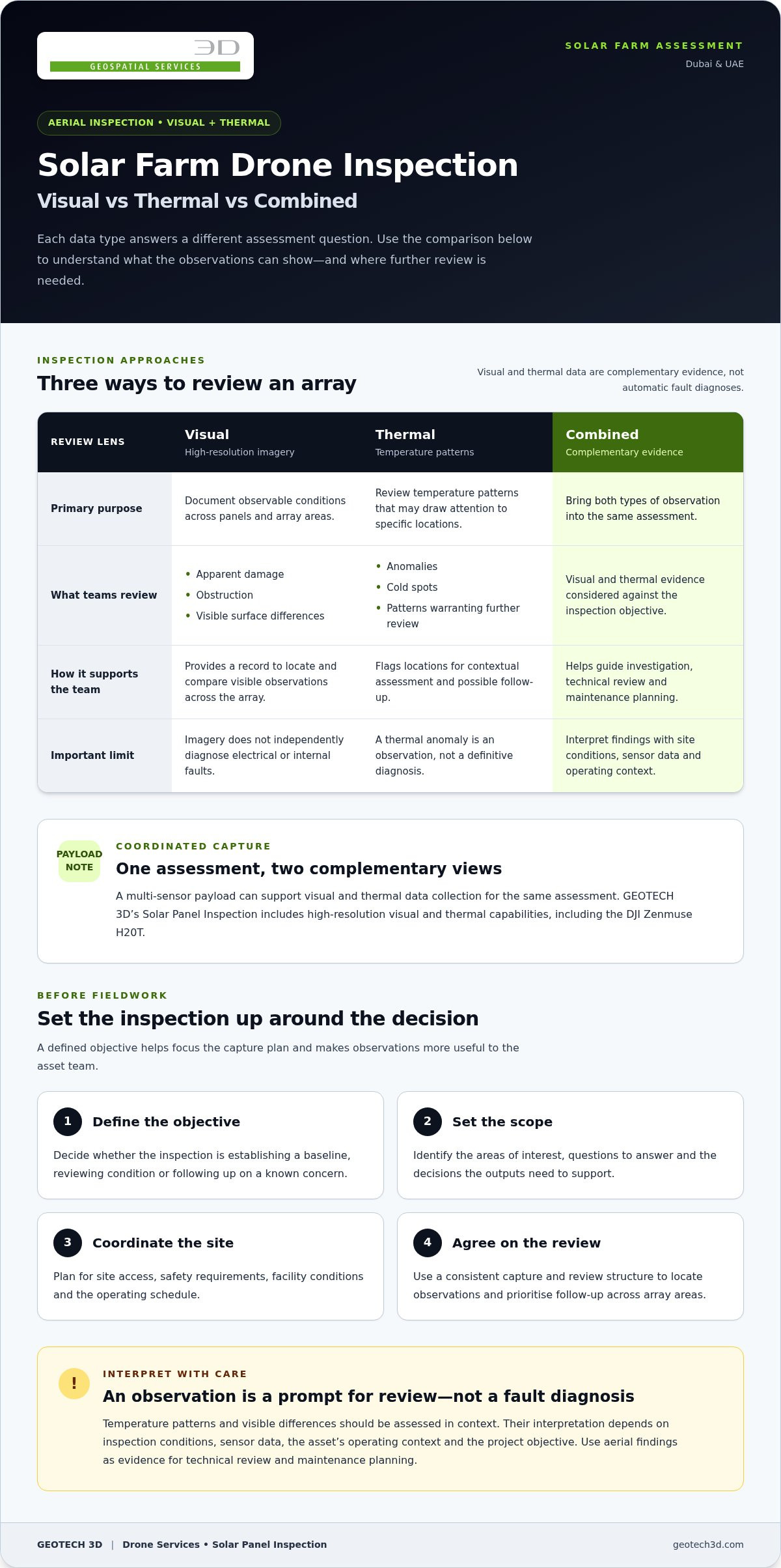
| Inspection approach | Primary purpose | What teams review |
|---|---|---|
| Visual | Document observable conditions | Visible damage, obstruction and apparent surface issues |
| Thermal | Review temperature patterns | Anomalies or cold spots that may need contextual assessment |
| Combined | Bring complementary observations together | Visual and thermal evidence considered against the inspection objective |
On a large site, consistent coverage and a clear review structure make it easier to assess observations across array areas. The aim is not to treat every image or temperature variation as a fault. Use the collected data to locate observations, prioritise follow-up and support technical review. GEOTECH 3D’s Drone Services and Solar Panel Inspection combine visual and thermal inspection for solar farm assessment in Dubai and across the UAE.
What drone inspection can and cannot tell solar farm teams
Aerial inspection provides evidence, not a complete diagnosis. Visual and thermal observations can help asset teams identify areas that merit review, but they do not establish the cause of every irregularity or prescribe maintenance on their own. The value of drone inspection for solar farms depends on interpreting the data alongside site conditions, operational context and relevant asset records.
Where aerial inspection adds practical value
Across broad arrays, aerial data collection provides a structured view of areas that may be difficult or inefficient to assess from the ground. It can also reduce the need for personnel to move among inspected assets during data capture. Teams can use clearly referenced observations to prioritise locations for closer investigation, focusing follow-up rather than treating every recorded variation as a confirmed fault.
Visual and thermal observations contribute different evidence. For example, a visible surface issue and a nearby thermal anomaly may together direct attention to a particular panel area. Neither observation proves the underlying cause. Their value is in making review more targeted and giving engineers a clearer starting point for further assessment.
Limitations and interpretation safeguards
Thermal patterns are indicators, not standalone proof of a specific defect. Their significance can depend on factors such as the asset’s operating state, viewing conditions and the quality and completeness of the captured data. If these conditions limit the evidence, conclusions may need to be qualified or the area assessed through another appropriate method.
Keep the steps distinct:
- Recorded observation: A visible condition or temperature pattern at a stated location.
- Technical interpretation: An assessment of what the observation may indicate, considered against site conditions and available records.
- Decision: An engineering conclusion or maintenance recommendation based on the broader evidence.
This distinction helps prevent a flagged anomaly from being mistaken for a confirmed failure. Inspection data can support prioritisation and follow-up, while engineering teams determine what the evidence means for the asset and what action is appropriate.
For solar farm projects in Dubai and across the UAE, define the intended use of inspection data before collection. Share relevant concerns, asset records and operating context with the project team so findings can be reviewed against the right questions. GEOTECH 3D’s integrated visual and thermal inspection capabilities support data collection with site safety in focus.
How to plan a solar farm drone inspection in Dubai or the UAE
A useful inspection plan connects the data being collected to an asset decision. Before fieldwork, define what the team needs to assess, which areas matter most and how the findings will be used. This keeps the scope focused and aligns site coordination, data capture and reporting expectations.
Prepare the inspection scope and site information
Start with a clear brief. Provide the available asset layout, areas of interest, access constraints and relevant operating context. Specify whether the objective calls for visual inspection, thermal inspection or both, and note known concerns that should guide the review. For example, a baseline assessment may call for broad, consistent coverage, while a follow-up may focus on particular sections of the array.
Agree in advance what decisions the observations will support. The team might use the data to identify locations for closer technical assessment, inform maintenance planning or compare conditions during a future review. Clear objectives help keep the inspection proportionate to the project’s needs.
Coordinate safe fieldwork and useful deliverables
Plan site coordination around active operations. Align access arrangements, work areas and timing with the people responsible for the facility, and account for site safety procedures. Required permissions and procedures depend on the project, location and site conditions. Include this coordination in the planning process rather than leaving it until fieldwork is about to begin.
Before collection, agree on expected outputs and how they should support review. Consider these questions:
- Which asset areas should be covered, and how should locations be identified?
- Should visual and thermal observations be reviewed together or for distinct objectives?
- What context or existing records will help the team interpret findings?
- Who will review observations and determine any follow-up assessment?
These decisions give the inspection team a practical framework for collecting relevant data and presenting it in a form the asset team can use. For solar projects in Dubai and across the UAE, site-specific planning helps account for operational priorities without assuming the same setup suits every facility.
For a coordinated approach to drone inspection for solar farms, GEOTECH 3D’s Drone Services include Solar Panel Inspection with visual and thermal data collection. Explore the service to align inspection planning with your project objectives.
How GEOTECH 3D supports solar farm drone inspection
Effective drone inspection for solar farms starts with the asset team’s objectives. GEOTECH 3D provides Solar Panel Inspection as part of its Drone Services, collecting visual and thermal data for solar farm condition assessment in Dubai and across the UAE. The inspection scope is shaped around the areas to assess and the questions the data needs to inform.
Aerial inspection capabilities for solar assets
Solar Panel Inspection is part of GEOTECH 3D’s wider Aerial Inspection capability. Integrated visual and thermal inspection combines high-resolution visual data with thermal observations to help identify anomalies, cold spots and signs of internal damage without requiring ground personnel among the inspected assets. The DJI Zenmuse H20T is a multi-sensor payload used for these inspection capabilities.
Each data type supports a different review purpose. Visual information records observable conditions, while thermal data can flag patterns for further assessment. Considered together, they provide complementary evidence for review against project objectives. Findings support assessment and follow-up, but do not replace engineering diagnosis or maintenance decisions.
From inspection objectives to informed next steps
Project objectives guide both the inspection approach and the review of observations. A team establishing a condition baseline may need a different scope from one following up on specific areas of concern. Defining priorities in advance helps focus data collection and gives reviewers context for interpreting the findings.
After inspection, asset teams can use documented findings as inputs to their own assessment and decisions. Relevant site context and existing records help put observations in perspective. For teams considering how geospatial information can contribute to wider asset planning, GEOTECH 3D also provides a digital twin for asset lifecycle.
GEOTECH 3D emphasizes disciplined planning, safety requirements, accuracy and reliable data collection. A project-specific scope aligns the inspection with site conditions and the intended use of its findings, supporting a considered process from preparation through review.
Turn solar inspection data into confident next steps
For solar assets in Dubai and across the UAE, drone inspection for solar farms is most useful when its scope is built around a clear assessment objective. Visual and thermal data provide complementary observations. Site context and engineering review help teams determine what those observations mean and whether further investigation is needed.
GEOTECH 3D’s Solar Panel Inspection is part of its Drone Services. Integrated visual and thermal inspection using the DJI Zenmuse H20T multi-sensor payload supports data collection that can help asset teams identify anomalies, cold spots and signs of internal damage. Careful planning keeps the inspection focused on project needs and site safety.
With a defined scope and useful outputs, teams can make informed decisions about follow-up assessment and maintenance planning. Start by setting out your solar farm’s inspection objectives and the information your team needs.
A considered inspection approach helps your team move from aerial observations to practical asset decisions.
Frequently Asked Questions
What is drone inspection for solar farms?
Drone inspection for solar farms is planned aerial data collection to assess panel and site conditions. Depending on the inspection objective, a drone captures visual imagery, thermal data or both. Asset teams can review observations across the array and identify areas for closer assessment. The data supports condition review and maintenance planning, but does not automatically diagnose faults or replace engineering judgment.
Can drones detect damaged solar panels?
Drones can capture high-resolution visual data that helps teams identify and document apparent panel damage, obstruction or surface issues. Thermal inspection can also flag anomalies or cold spots for further review. These observations help locate areas of concern across an array, but do not confirm the cause or severity of a fault on their own. Engineering assessment and other relevant evidence may be needed to determine next steps.
How does thermal drone inspection of solar panels work?
Thermal drone inspection records temperature patterns across solar panels and highlights areas that differ from their surroundings. These patterns may reveal anomalies or cold spots not apparent in visual imagery. Interpretation depends on inspection conditions, sensor data, the panels’ operating context and the project objective. Thermal findings are indicators for review, not definitive diagnoses, so assess them alongside other available information.
Is drone inspection better than ground-based solar panel inspection?
Neither approach is universally better; each supports different inspection needs. Aerial collection can provide a coordinated view across large arrays and reduce the need for personnel to move among inspected assets during data capture. Ground-based assessment may still be relevant for closer investigation of specific concerns. Define the objective first, then determine how aerial observations and follow-up assessment should work together.
What should a solar farm prepare before a drone inspection?
Prepare the asset layout, inspection scope, areas of concern, access constraints and relevant operating context. Clarify whether the objective calls for visual data, thermal data or both, and how the observations will inform assessment or maintenance planning. Coordinate site access and safety procedures with the people responsible for the facility. Agree on expected outputs and who will review findings and determine follow-up action.
Can drone inspection be used for solar farms in Dubai and the UAE?
Yes. GEOTECH 3D provides Solar Panel Inspection within its Drone Services in Dubai and across the UAE. Plan around the particular site, its operating requirements, access arrangements and project-specific permissions or procedures. Defining these details with the asset team aligns data collection with the assessment objective and supports safe, coordinated fieldwork.
What can thermal inspection show that visual inspection may not?
Thermal inspection can reveal temperature patterns, including anomalies and cold spots, that may not be visible in standard visual imagery. Visual inspection documents observable surface conditions, while thermal data adds another type of evidence for asset teams to consider. A flagged pattern does not prove a specific defect. Its significance depends on inspection conditions, sensor data and operational context, and may require further technical assessment.
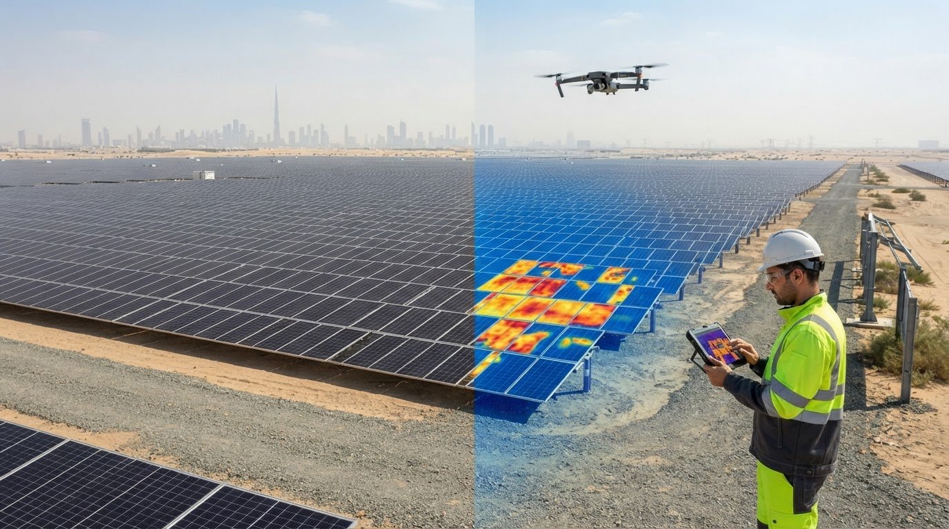
A clean-looking panel array doesn’t always tell the whole story. Across a large solar farm, ground-level checks can take time to coordinate, and a visual review alone may not reveal thermal patterns worth investigating. Drone inspection for solar farms combines aerial visual and thermal data to help teams assess asset conditions across a site, while reducing the need to place personnel among the arrays during data capture.
For developers, operators and project teams in Dubai and across the UAE, begin with the decision the inspection needs to support. Are you documenting visible conditions, identifying areas for closer assessment, or establishing a condition record for maintenance planning? A defined objective helps focus the capture plan and makes the resulting observations more useful.
This guide explains how visual and thermal inspection work together, what to prepare, and how to set expectations for reviewing the findings. It also covers GEOTECH 3D’s Drone Services and Solar Panel Inspection, which use high-resolution visual and thermal capture, including the DJI Zenmuse H20T, to support solar farm assessment in the UAE.
Key Takeaways
- Start drone inspection for solar farms with a clear assessment question, so visual and thermal data serve a defined purpose.
- Use visual imagery to document observable conditions and thermal data to flag patterns that may need closer assessment.
- Treat aerial findings as evidence for review and maintenance planning, not as an automatic diagnosis of a fault.
- Before fieldwork, define the inspection scope, areas of interest, site access requirements and decisions the outputs need to support.
- GEOTECH 3D’s Solar Panel Inspection combines high-resolution visual and thermal inspection capabilities, including the DJI Zenmuse H20T payload.
Drone inspection for solar farms: what it assesses and why it matters
Drone inspection for solar farms is planned aerial data collection to assess panels and other visible conditions across a site. Instead of relying only on ground-level checks, teams can collect visual and thermal information across an array using a defined scope. Start by identifying the decision the asset team needs to make, such as establishing a baseline, reviewing condition or following up on a known concern.
Visual and thermal data answer different questions. High-resolution visual imagery can document apparent damage, obstruction and surface conditions. Thermal inspection can highlight anomalies and cold spots that may warrant further review. Together, these sources provide complementary evidence. They help guide investigation, but do not replace engineering diagnosis or maintenance decisions.
What can a solar panel drone inspection reveal?
Visual observations can help teams locate and record areas that appear damaged, obstructed or different from surrounding panels. Thermal data can reveal temperature patterns that merit attention. Interpretation depends on inspection conditions, sensor data and the project objective. A thermal anomaly is an observation to assess, not a definitive diagnosis. For context, active thermography describes imaging after an external energy source is applied. This differs from aerial inspection that records thermal patterns without implying that active heating is used.
When should asset teams consider aerial inspection?
Teams may use aerial inspection to establish a baseline, carry out a scheduled condition assessment or follow up on identified concerns. The timing and scope depend on site scale, access arrangements, operational priorities and the questions the inspection needs to answer. In Dubai and across the UAE, plan around the facility’s conditions and operating schedule rather than assuming one approach suits every site.
A consistent capture plan can help teams review extensive arrays against a defined scope. Before fieldwork, identify the areas to assess, the questions to answer and how the findings will inform asset review. Coordinate access and safety requirements as part of that plan. Aerial data collection can support assessment without requiring personnel to walk among every panel. GEOTECH 3D’s Drone Services include Solar Panel Inspection with integrated visual and thermal capabilities for high-resolution solar farm condition assessment.
How visual and thermal drone inspection work on solar farms
Visual and thermal data provide different views of a solar array. Visual imagery records observable conditions on and around panels, while thermal data shows temperature patterns that may draw attention to specific areas. Combining these sources helps teams review observations in context instead of relying on a single type of evidence.
Visual inspection: documenting observable panel conditions
High-resolution visual data gives teams a record to review for apparent surface damage, obstruction and other visible differences across the array. A consistent capture plan makes the review more structured: teams can compare areas, locate observations and identify where closer inspection may be useful. Imagery documents visible evidence, but does not independently diagnose electrical or internal faults.
Thermal inspection: interpreting temperature patterns carefully
Thermal inspection records temperature patterns across the areas being assessed. Anomalies and cold spots can flag locations for further review, but remain observations rather than confirmed diagnoses. Their interpretation depends on inspection conditions, sensor data and the asset’s operating context. Consider these factors before drawing conclusions or deciding on maintenance action.
A multi-sensor payload can support coordinated visual and thermal data collection, allowing both views to inform the same assessment. GEOTECH 3D uses the DJI Zenmuse H20T multi-sensor payload for its documented inspection capabilities. The right approach depends on the project’s objectives and the information needed for review.
| Inspection approach | Primary purpose | What teams review |
|---|---|---|
| Visual | Document observable conditions | Visible damage, obstruction and apparent surface issues |
| Thermal | Review temperature patterns | Anomalies or cold spots that may need contextual assessment |
| Combined | Bring complementary observations together | Visual and thermal evidence considered against the inspection objective |
On a large site, consistent coverage and a clear review structure make it easier to assess observations across array areas. The aim is not to treat every image or temperature variation as a fault. Use the collected data to locate observations, prioritise follow-up and support technical review. GEOTECH 3D’s Drone Services and Solar Panel Inspection combine visual and thermal inspection for solar farm assessment in Dubai and across the UAE.
What drone inspection can and cannot tell solar farm teams
Aerial inspection provides evidence, not a complete diagnosis. Visual and thermal observations can help asset teams identify areas that merit review, but they do not establish the cause of every irregularity or prescribe maintenance on their own. The value of drone inspection for solar farms depends on interpreting the data alongside site conditions, operational context and relevant asset records.
Where aerial inspection adds practical value
Across broad arrays, aerial data collection provides a structured view of areas that may be difficult or inefficient to assess from the ground. It can also reduce the need for personnel to move among inspected assets during data capture. Teams can use clearly referenced observations to prioritise locations for closer investigation, focusing follow-up rather than treating every recorded variation as a confirmed fault.
Visual and thermal observations contribute different evidence. For example, a visible surface issue and a nearby thermal anomaly may together direct attention to a particular panel area. Neither observation proves the underlying cause. Their value is in making review more targeted and giving engineers a clearer starting point for further assessment.
Limitations and interpretation safeguards
Thermal patterns are indicators, not standalone proof of a specific defect. Their significance can depend on factors such as the asset’s operating state, viewing conditions and the quality and completeness of the captured data. If these conditions limit the evidence, conclusions may need to be qualified or the area assessed through another appropriate method.
Keep the steps distinct:
- Recorded observation: A visible condition or temperature pattern at a stated location.
- Technical interpretation: An assessment of what the observation may indicate, considered against site conditions and available records.
- Decision: An engineering conclusion or maintenance recommendation based on the broader evidence.
This distinction helps prevent a flagged anomaly from being mistaken for a confirmed failure. Inspection data can support prioritisation and follow-up, while engineering teams determine what the evidence means for the asset and what action is appropriate.
For solar farm projects in Dubai and across the UAE, define the intended use of inspection data before collection. Share relevant concerns, asset records and operating context with the project team so findings can be reviewed against the right questions. GEOTECH 3D’s integrated visual and thermal inspection capabilities support data collection with site safety in focus.
How to plan a solar farm drone inspection in Dubai or the UAE
A useful inspection plan connects the data being collected to an asset decision. Before fieldwork, define what the team needs to assess, which areas matter most and how the findings will be used. This keeps the scope focused and aligns site coordination, data capture and reporting expectations.
Prepare the inspection scope and site information
Start with a clear brief. Provide the available asset layout, areas of interest, access constraints and relevant operating context. Specify whether the objective calls for visual inspection, thermal inspection or both, and note known concerns that should guide the review. For example, a baseline assessment may call for broad, consistent coverage, while a follow-up may focus on particular sections of the array.
Agree in advance what decisions the observations will support. The team might use the data to identify locations for closer technical assessment, inform maintenance planning or compare conditions during a future review. Clear objectives help keep the inspection proportionate to the project’s needs.
Coordinate safe fieldwork and useful deliverables
Plan site coordination around active operations. Align access arrangements, work areas and timing with the people responsible for the facility, and account for site safety procedures. Required permissions and procedures depend on the project, location and site conditions. Include this coordination in the planning process rather than leaving it until fieldwork is about to begin.
Before collection, agree on expected outputs and how they should support review. Consider these questions:
- Which asset areas should be covered, and how should locations be identified?
- Should visual and thermal observations be reviewed together or for distinct objectives?
- What context or existing records will help the team interpret findings?
- Who will review observations and determine any follow-up assessment?
These decisions give the inspection team a practical framework for collecting relevant data and presenting it in a form the asset team can use. For solar projects in Dubai and across the UAE, site-specific planning helps account for operational priorities without assuming the same setup suits every facility.
For a coordinated approach to drone inspection for solar farms, GEOTECH 3D’s Drone Services include Solar Panel Inspection with visual and thermal data collection. Explore the service to align inspection planning with your project objectives.
How GEOTECH 3D supports solar farm drone inspection
Effective drone inspection for solar farms starts with the asset team’s objectives. GEOTECH 3D provides Solar Panel Inspection as part of its Drone Services, collecting visual and thermal data for solar farm condition assessment in Dubai and across the UAE. The inspection scope is shaped around the areas to assess and the questions the data needs to inform.
Aerial inspection capabilities for solar assets
Solar Panel Inspection is part of GEOTECH 3D’s wider Aerial Inspection capability. Integrated visual and thermal inspection combines high-resolution visual data with thermal observations to help identify anomalies, cold spots and signs of internal damage without requiring ground personnel among the inspected assets. The DJI Zenmuse H20T is a multi-sensor payload used for these inspection capabilities.
Each data type supports a different review purpose. Visual information records observable conditions, while thermal data can flag patterns for further assessment. Considered together, they provide complementary evidence for review against project objectives. Findings support assessment and follow-up, but do not replace engineering diagnosis or maintenance decisions.
From inspection objectives to informed next steps
Project objectives guide both the inspection approach and the review of observations. A team establishing a condition baseline may need a different scope from one following up on specific areas of concern. Defining priorities in advance helps focus data collection and gives reviewers context for interpreting the findings.
After inspection, asset teams can use documented findings as inputs to their own assessment and decisions. Relevant site context and existing records help put observations in perspective. For teams considering how geospatial information can contribute to wider asset planning, GEOTECH 3D also provides a digital twin for asset lifecycle.
GEOTECH 3D emphasizes disciplined planning, safety requirements, accuracy and reliable data collection. A project-specific scope aligns the inspection with site conditions and the intended use of its findings, supporting a considered process from preparation through review.
Turn solar inspection data into confident next steps
For solar assets in Dubai and across the UAE, drone inspection for solar farms is most useful when its scope is built around a clear assessment objective. Visual and thermal data provide complementary observations. Site context and engineering review help teams determine what those observations mean and whether further investigation is needed.
GEOTECH 3D’s Solar Panel Inspection is part of its Drone Services. Integrated visual and thermal inspection using the DJI Zenmuse H20T multi-sensor payload supports data collection that can help asset teams identify anomalies, cold spots and signs of internal damage. Careful planning keeps the inspection focused on project needs and site safety.
With a defined scope and useful outputs, teams can make informed decisions about follow-up assessment and maintenance planning. Start by setting out your solar farm’s inspection objectives and the information your team needs.
A considered inspection approach helps your team move from aerial observations to practical asset decisions.
Frequently Asked Questions
What is drone inspection for solar farms?
Drone inspection for solar farms is planned aerial data collection to assess panel and site conditions. Depending on the inspection objective, a drone captures visual imagery, thermal data or both. Asset teams can review observations across the array and identify areas for closer assessment. The data supports condition review and maintenance planning, but does not automatically diagnose faults or replace engineering judgment.
Can drones detect damaged solar panels?
Drones can capture high-resolution visual data that helps teams identify and document apparent panel damage, obstruction or surface issues. Thermal inspection can also flag anomalies or cold spots for further review. These observations help locate areas of concern across an array, but do not confirm the cause or severity of a fault on their own. Engineering assessment and other relevant evidence may be needed to determine next steps.
How does thermal drone inspection of solar panels work?
Thermal drone inspection records temperature patterns across solar panels and highlights areas that differ from their surroundings. These patterns may reveal anomalies or cold spots not apparent in visual imagery. Interpretation depends on inspection conditions, sensor data, the panels’ operating context and the project objective. Thermal findings are indicators for review, not definitive diagnoses, so assess them alongside other available information.
Is drone inspection better than ground-based solar panel inspection?
Neither approach is universally better; each supports different inspection needs. Aerial collection can provide a coordinated view across large arrays and reduce the need for personnel to move among inspected assets during data capture. Ground-based assessment may still be relevant for closer investigation of specific concerns. Define the objective first, then determine how aerial observations and follow-up assessment should work together.
What should a solar farm prepare before a drone inspection?
Prepare the asset layout, inspection scope, areas of concern, access constraints and relevant operating context. Clarify whether the objective calls for visual data, thermal data or both, and how the observations will inform assessment or maintenance planning. Coordinate site access and safety procedures with the people responsible for the facility. Agree on expected outputs and who will review findings and determine follow-up action.
Can drone inspection be used for solar farms in Dubai and the UAE?
Yes. GEOTECH 3D provides Solar Panel Inspection within its Drone Services in Dubai and across the UAE. Plan around the particular site, its operating requirements, access arrangements and project-specific permissions or procedures. Defining these details with the asset team aligns data collection with the assessment objective and supports safe, coordinated fieldwork.
What can thermal inspection show that visual inspection may not?
Thermal inspection can reveal temperature patterns, including anomalies and cold spots, that may not be visible in standard visual imagery. Visual inspection documents observable surface conditions, while thermal data adds another type of evidence for asset teams to consider. A flagged pattern does not prove a specific defect. Its significance depends on inspection conditions, sensor data and operational context, and may require further technical assessment.
Search Now
Error: Contact form not found.