

Our Services
Drone LiDAR Surveys in Saudi Arabia: How the Technology Works
The value of drone LiDAR is the measured surface beneath the flight, not simply the view from above. A drone LiDAR survey in Saudi Arabia uses a laser scanner that emits thousands of pulses per second and turns their returns into a dense 3D point cloud representing terrain and structures.
Choosing between LiDAR, photogrammetry and ground surveying depends on the site and the detail your project needs. This guide explains how a drone LiDAR survey collects and processes data, what affects accuracy, and how the technology differs from image-based mapping.
You’ll also learn how Saudi drone regulations apply and which survey approaches can support terrain modelling, construction monitoring and corridor mapping. The practical guidance can help you decide what the data needs to show and whether aerial surveying suits the work.
Key Takeaways
- Choose between image-based photogrammetry and laser scanning according to the terrain information and 3D deliverables your project requires.
- See how scanner, GNSS and IMU data work together to position and orient survey measurements.
- Commercial drone operations in Saudi Arabia require approval from the General Authority of Civil Aviation; corridor planning also needs to account for restricted zones and BVLOS operations.
- Assess expected accuracy in context: flight altitude, ground conditions, positioning methods and ground control all influence the final data.
- Explore how GEOTECH 3D’s topo survey and drone services can support project mapping needs, with 3D laser scanning as an option when built detail matters.
What is LiDAR Technology Using Drones?
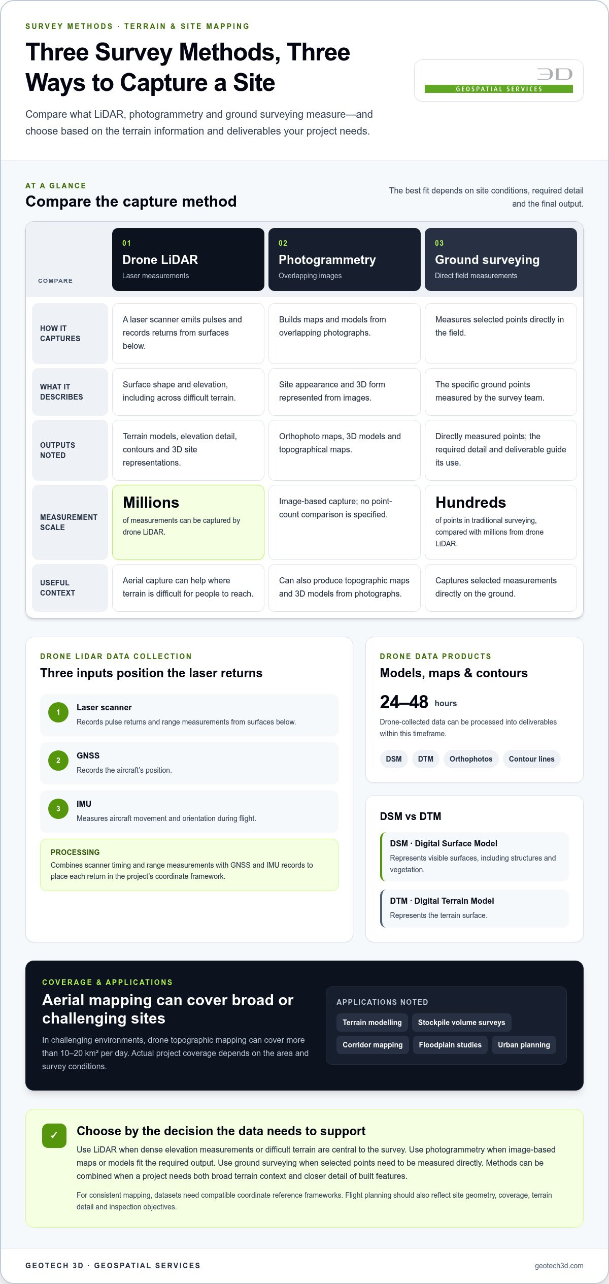
A drone LiDAR survey collects laser measurements from the air and processes them into mapped, three-dimensional site data. Unlike photogrammetry, which relies on overlapping photographs, LiDAR measures surfaces using laser returns. Unlike ground surveying, it can capture millions of measurements rather than hundreds of points.
Drone LiDAR and Digital Mapping
Digital mapping places drone-collected measurements into a geographic framework, while 3D laser scanning can add detailed information about built features. According to Európai Unió, photogrammetry creates 3D models from photographs, while LiDAR uses laser scanning to produce 3D representations of urban landscapes.
This integration matters when a project needs both a broad terrain view and more detailed built context. For example, a development team can use aerial mapping to understand site-wide levels, then combine it with 3D laser scanning data where buildings or other structures need closer documentation. The resulting datasets support a more coordinated view of existing conditions.
Terrain Models and Topographic Mapping
Terrain modelling represents the land surface, while topographic mapping communicates elevation and ground form through mapped features such as contour lines. Drone survey data can be processed into digital terrain models, maps and 3D site representations for land development planning and design.
For a proposed development, a topographic map helps teams assess slopes, low areas and elevation changes before planning a site layout. LiDAR measurements can support contour generation and terrain analysis, while photogrammetry can also produce topographic maps. Choose the output to suit the decision, whether that means understanding landform or reviewing the site context.
LiDAR, Photogrammetry, and Ground Surveys
Photogrammetry builds maps and models from overlapping images, while LiDAR records laser returns that describe surface shape and elevation. Drone photogrammetry can produce orthophoto maps, 3D models and topographical maps. LiDAR provides another way to capture elevation detail, including across difficult terrain.
Ground surveying measures selected points directly in the field, while drone LiDAR can capture millions of measurements compared with hundreds in traditional surveying. The denser dataset is useful, but the methods are not interchangeable. Required detail, terrain and deliverables determine whether aerial LiDAR, photogrammetry or ground measurements are appropriate, or whether a combination is needed.
Drone Mapping Benefits and Applications
Drone mapping gathers site information from above, which can be useful where terrain is difficult for people to reach. In challenging environments, drone topographic mapping can cover more than 10-20 km² per day. Actual project coverage depends on the area and survey conditions.
Applications include terrain modelling, stockpile volume surveys, corridor mapping, floodplain studies and urban planning. For a land development project, mapped elevation data can inform planning and design; for a corridor, it can describe terrain along the route. Where built detail is also needed, drone survey data can be integrated with digital mapping and 3D laser scanning.
Laser scanner, GNSS and IMU data collection
A drone survey uses an unmanned aerial vehicle (UAV) equipped with sensors to collect information from above. In a LiDAR setup, a laser scanner emits pulses and records their returns from surfaces below. Each return contributes a measured point, and the flight path determines where the sensor observes the site. A high-resolution camera can also collect imagery for visual context during a drone lidar survey Saudi Arabia.
GNSS and an inertial measurement unit (IMU) help locate and orient the measurements. GNSS records the aircraft’s position, while the IMU measures its movement and orientation during flight. Processing combines these records with the scanner’s timing and range measurements, placing each laser return in the project’s coordinate framework. Consistent positioning is particularly important on long corridors, where the survey must map the route coherently.
Flight planning shapes data collection. A fixed-wing UAV and a multirotor LiDAR drone are different platforms, and site geometry helps determine which is practical. A long, open infrastructure corridor calls for a different flight pattern from a compact construction site with structures or limited room to manoeuvre. Plan the route to achieve the required coverage, terrain detail and inspection objective.
After capture, processing organizes the survey measurements into usable geospatial deliverables. Drone-collected data can be developed into digital surface models (DSMs), digital terrain models (DTMs), orthophotos and contour lines within 24-48 hours. A DSM represents visible surfaces, including structures and vegetation; a DTM represents the terrain surface. GIS-ready outputs let project teams view mapped information alongside other spatial layers, such as infrastructure alignments or construction boundaries.
The survey’s purpose affects how teams interpret the results. A road-planning team, for instance, may use terrain contours to examine ground form, while an asset inspection may focus on mapped surface features. GIS integration lets planners compare these outputs with project boundaries and other location-based information. The datasets must use compatible coordinate reference frameworks to align correctly on a shared map.
For infrastructure planning across the region, geospatial data can describe terrain and features along a proposed corridor. GEOTECH 3D delivers reliable results for these operations. The capture plan should account for corridor width and terrain complexity, which influence flight coverage and the resulting dataset. GNSS positioning and IMU orientation connect measurements across the flight; processed layers can then support infrastructure planning and GIS workflows.
Is drone surveying regulated in Saudi Arabia?
Yes. Commercial drone operations in Saudi Arabia require approval from the General Authority of Civil Aviation (GACA). Corridor surveys must also comply with aviation rules for beyond visual line of sight (BVLOS) operations and restricted zones.
To plan a survey, define the site or corridor, specify the intended deliverables, and design a flight plan around corridor width and terrain complexity. Address applicable GACA approval and any BVLOS or restricted-zone requirements before flying. Then process and review the data against the project’s mapping needs.
Key risks include airspace restrictions, BVLOS requirements and gaps in ground control. Vegetation, steep terrain and limited site access can also affect what the sensor captures and how the surface is interpreted. For example, point-cloud classification may need to distinguish vegetation returns from ground returns.
Terrain and site conditions shape flight planning and data coverage. Slopes and vegetation affect the laser’s view of the ground, while corridor width and terrain complexity influence the flight route. Climate and local operating conditions also matter for planning and safe data collection, so the survey approach must suit the site.
A drone-mounted LiDAR sensor records laser returns that processing combines into a point cloud containing millions of points. Together, the points represent a target’s three-dimensional shape and surface characteristics. Classification can separate ground, vegetation and structures, helping analysts interpret the site instead of treating every return as the same surface.
Point-cloud classification supports different mapping outputs. A digital terrain model represents the ground surface, while a digital surface model can include visible structures and vegetation. Orthomosaics add a mapped aerial image, and point clouds can generate topographic contour maps at 10-50 cm intervals. The chosen output should reflect the planned engineering or land-management use.
Ground control points are still important for drone LiDAR, even when aerial capture covers a large area. Surveyed control points can help strengthen vertical accuracy in corridor mapping. Place them with the route and terrain in mind so survey teams have reference positions for assessing the dataset.
For corridor work, address GACA approval and airspace constraints first, then plan the route, incorporate ground control and select suitable outputs. A transmission-line survey, for example, needs a flight plan suited to its corridor and terrain, along with mapped data that supports the intended review.
LiDAR accuracy and night operations
Drone LiDAR accuracy depends on positioning, flight altitude and ground conditions. Coverage planning matters too: flight lines must collect enough data for the intended mapping, monitoring or environmental analysis.
Drone LiDAR Range and Accuracy
Accuracy describes how closely mapped measurements represent their true positions, while range affects which surfaces the sensor can capture. Typical drone LiDAR data has vertical accuracy of 2-5 cm and horizontal accuracy of 1-3 cm, depending on flight altitude and ground conditions.
These figures help frame project requirements, but they do not guarantee a particular result at every site. A terrain model for assessing broad landform, for example, has different requirements from a detailed infrastructure inspection. Flight planning and surface conditions affect measurements, so match the required precision to the intended analysis and deliverables.
GNSS and Ground Control Accuracy
RTK and PPK GNSS systems used for drone topographic mapping can provide centimetre-level accuracy. They help position captured measurements using GNSS observations, placing mapped points within a coordinate framework.
Ground control points provide surveyed reference locations for checking and strengthening the dataset. In a corridor survey, they can help assess vertical accuracy along a route where terrain and flight geometry may vary. Combining GNSS positioning with ground control supports a more reliable accuracy assessment than assuming the point cloud validates itself.
Area coverage and measurement precision are related, but they are separate planning considerations. A fast flight over a large site does not, by itself, establish the accuracy of every mapped feature. Consider the flight path, terrain variation and intended output, then assess whether the data provides enough detail for the project’s decisions.
Night operations require distinguishing laser measurements from camera imagery. LiDAR records laser returns, while photographs rely on visible light and suitable illumination. If a survey combines LiDAR with RGB imagery, darkness can affect image collection even when laser measurement remains part of the workflow. This distinction matters when a project needs both elevation data and visual interpretation.
For monitoring, consistent collection conditions make comparisons more useful. A construction team reviewing site changes, for example, needs mapped data that can be aligned across survey periods. Environmental analysis may instead focus on terrain or vegetation patterns. In either case, GNSS positioning, ground control and comparable flight planning help analysts distinguish actual changes from differences in capture conditions.
In Saudi Arabia, define the required horizontal and vertical accuracy before planning coverage or night work. That requirement guides flight altitude, GNSS approach, control-point placement and the role of imagery. The plan should connect precision to a practical purpose, such as terrain analysis, infrastructure monitoring or site inspection.
LiDAR survey solutions in Saudi Arabia
A drone LiDAR survey in Saudi Arabia can produce georeferenced orthomosaics in the Saudi National Coordinate System (SNCS). Survey data can also be processed into digital surface models, digital terrain models, orthophotos and contour lines within 24-48 hours. These deliverables give engineering teams distinct ways to examine site conditions, from mapped imagery to elevation information.
Start with the decisions the project needs to support. A land development team may need topographic information for planning and design, while a construction team may need repeat site capture for progress monitoring. Corridor mapping has different demands: its flight plan must account for corridor width and terrain complexity. Defining outputs early helps align collection methods with the intended engineering use.
For large areas, drone collection can change field coverage. A drone survey can cover more than 500 hectares in a day, while a ground crew might survey 10-20 hectares in the same timeframe as a drone flight. The comparison illustrates a potential coverage advantage, not a universal production rate. Site access, terrain, flight planning and required detail all influence the practical approach.
Linear infrastructure offers another useful comparison. A drone topographic mapping flight can survey an 8-kilometer transmission-line distance in one 30-minute flight. A traditional GPS surveyor can cover about 8 kilometers of transmission line per day in Saudi Arabia, based on an 8-hour shift. For an engineering team assessing corridor methods, the contrast highlights how aerial capture may support route-wide data collection.
Construction applications include progress monitoring, stockpile measurement and site accuracy checks. Survey data can also support mapping roads, bridges and drainage infrastructure. A stockpile survey, for example, provides mapped surface information for volume analysis, while corridor data can help teams assess terrain along a proposed route. Match the deliverable to the task rather than relying on one output for every decision.
Drone surveys can help environmental projects track vegetation, water management and coastal change. Urban management teams can use current mapping to support smart-city planning. These applications have different resolution and coverage needs: a broad overview is not a substitute for detailed surface information. LiDAR and RGB data can complement one another on infrastructure projects, combining surface measurements with imagery where both are useful.
Saudi Arabia’s Vision 2030 includes energy transmission projects spanning hundreds of kilometers. For such corridors, the takeaway is practical: select survey methods around route length, terrain, required outputs and aviation constraints. Large-area coverage can make aerial collection valuable, while ground control and coordinated mapping remain important to producing data suited to engineering decisions.
GEOTECH 3D: topo survey
GEOTECH 3D provides topo survey and Drone Services for projects that need mapped site information to support planning and design. A topographic survey can help developers and engineering teams understand landform and existing conditions before decisions about site layout or infrastructure proceed.
For broader spatial workflows, GIS & Surveying Services can help organize geospatial information, while 3D Laser Scanning can capture built environments where detailed existing-condition data matters. The appropriate approach depends on the site and the information the project needs, such as terrain mapping, aerial data or built detail.
If you’re planning a survey in Dubai or elsewhere in the UAE, contact GEOTECH 3D to discuss your project, or visit GEOTECH 3D.
Turn survey requirements into a clear project brief
Start by defining the decision the survey must support. For a drone LiDAR survey in Saudi Arabia, set out the site or corridor limits, intended use, coordinate reference, accuracy needs and deliverables. These priorities connect data collection and processing to planning, engineering or asset management, rather than producing information without a defined purpose.
For projects in Dubai and the UAE, GEOTECH 3D offers topo survey, 3D Laser Scanning, and Drone Services. The right combination depends on whether your priority is terrain mapping, detailed built-environment capture, or aerial survey data. A clear scope gives project teams a practical basis for aligning survey outputs with design and delivery requirements.
Once your survey objectives are clear, your team can identify the data needed to support the next project decision.
Frequently Asked Questions
Can drone surveys cover large areas like NEOM or remote desert sites?
Drone surveys can map extensive sites and remote desert terrain, with flight planning shaped by boundaries, access, airspace and terrain. NEOM is an example of a large development context, not a claim about a completed survey. For a remote site, divide the scope into practical flight areas and consider how ground control and required outputs fit the project as a whole. Site conditions determine the capture plan.
What is a drone LiDAR survey and how does it work?
A drone LiDAR survey uses an airborne laser scanner to measure surfaces and create geospatial data. GNSS positioning and an inertial measurement unit associate measurements with the aircraft’s location and orientation. Processing organizes the captured data into outputs such as a point cloud or elevation model. Specify the coordinate reference and intended use so the data fits existing mapping workflows.
Which drone LiDAR survey providers operate in Saudi Arabia?
GEOTECH 3D provides drone-based surveying and lists a Riyadh location in Saudi Arabia. Its relevant capabilities include Drone Services, topo survey, and GIS & Surveying Services. These can support projects that need aerial data collection or mapped terrain information. For work in Saudi Arabia, the project scope should identify the site, intended deliverables and applicable operating constraints so the survey approach aligns with its engineering purpose.
What permits and regulations apply to drone LiDAR surveys in Saudi Arabia?
Commercial drone operations in Saudi Arabia require approval from the General Authority of Civil Aviation (GACA). Corridor work must account for aviation rules on beyond visual line of sight (BVLOS) operations and restricted zones. These requirements affect whether a planned route and operating method can proceed. A long linear survey, for example, needs a flight plan that accounts for relevant airspace restrictions and required approvals.
What accuracy and point density can drone LiDAR surveys achieve?
Typical drone LiDAR data has vertical accuracy of 2-5 cm and horizontal accuracy of 1-3 cm, depending on flight altitude and ground conditions. The point cloud can contain millions of measured points, but point count alone doesn’t establish survey quality. GNSS positioning, ground control and the project’s required level of detail all matter when assessing whether the data suits design, monitoring or mapping decisions.
Which Saudi industries use drone LiDAR surveying, and for what applications?
Construction and infrastructure teams can use drone surveys for progress monitoring, stockpile measurement and site mapping. Utilities can use corridor data for transmission-line planning, while environmental studies may examine vegetation, water management or coastal change. Urban management teams can use current mapping for smart-city projects. The right application depends on the decision: a stockpile assessment calls for a different interpretation from a terrain study or infrastructure route review.
What deliverables and file formats are included in a drone LiDAR survey?
Common deliverables include a point cloud, digital surface model, digital terrain model, orthophoto and contour lines. The appropriate file formats depend on how the team will use the information, such as importing mapped layers into GIS or using terrain data in design workflows. Define the coordinate reference and required deliverables in the project scope so the data aligns with existing engineering systems.
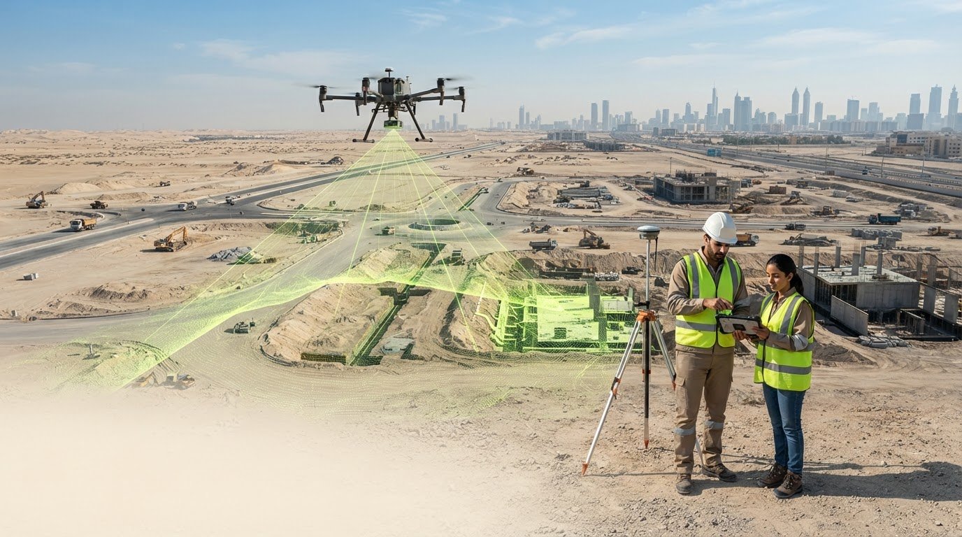
The value of drone LiDAR is the measured surface beneath the flight, not simply the view from above. A drone LiDAR survey in Saudi Arabia uses a laser scanner that emits thousands of pulses per second and turns their returns into a dense 3D point cloud representing terrain and structures.
Choosing between LiDAR, photogrammetry and ground surveying depends on the site and the detail your project needs. This guide explains how a drone LiDAR survey collects and processes data, what affects accuracy, and how the technology differs from image-based mapping.
You’ll also learn how Saudi drone regulations apply and which survey approaches can support terrain modelling, construction monitoring and corridor mapping. The practical guidance can help you decide what the data needs to show and whether aerial surveying suits the work.
Key Takeaways
- Choose between image-based photogrammetry and laser scanning according to the terrain information and 3D deliverables your project requires.
- See how scanner, GNSS and IMU data work together to position and orient survey measurements.
- Commercial drone operations in Saudi Arabia require approval from the General Authority of Civil Aviation; corridor planning also needs to account for restricted zones and BVLOS operations.
- Assess expected accuracy in context: flight altitude, ground conditions, positioning methods and ground control all influence the final data.
- Explore how GEOTECH 3D’s topo survey and drone services can support project mapping needs, with 3D laser scanning as an option when built detail matters.
What is LiDAR Technology Using Drones?
A drone LiDAR survey collects laser measurements from the air and processes them into mapped, three-dimensional site data. Unlike photogrammetry, which relies on overlapping photographs, LiDAR measures surfaces using laser returns. Unlike ground surveying, it can capture millions of measurements rather than hundreds of points.
Drone LiDAR and Digital Mapping
Digital mapping places drone-collected measurements into a geographic framework, while 3D laser scanning can add detailed information about built features. According to Európai Unió, photogrammetry creates 3D models from photographs, while LiDAR uses laser scanning to produce 3D representations of urban landscapes.
This integration matters when a project needs both a broad terrain view and more detailed built context. For example, a development team can use aerial mapping to understand site-wide levels, then combine it with 3D laser scanning data where buildings or other structures need closer documentation. The resulting datasets support a more coordinated view of existing conditions.
Terrain Models and Topographic Mapping
Terrain modelling represents the land surface, while topographic mapping communicates elevation and ground form through mapped features such as contour lines. Drone survey data can be processed into digital terrain models, maps and 3D site representations for land development planning and design.
For a proposed development, a topographic map helps teams assess slopes, low areas and elevation changes before planning a site layout. LiDAR measurements can support contour generation and terrain analysis, while photogrammetry can also produce topographic maps. Choose the output to suit the decision, whether that means understanding landform or reviewing the site context.
LiDAR, Photogrammetry, and Ground Surveys
Photogrammetry builds maps and models from overlapping images, while LiDAR records laser returns that describe surface shape and elevation. Drone photogrammetry can produce orthophoto maps, 3D models and topographical maps. LiDAR provides another way to capture elevation detail, including across difficult terrain.
Ground surveying measures selected points directly in the field, while drone LiDAR can capture millions of measurements compared with hundreds in traditional surveying. The denser dataset is useful, but the methods are not interchangeable. Required detail, terrain and deliverables determine whether aerial LiDAR, photogrammetry or ground measurements are appropriate, or whether a combination is needed.
Drone Mapping Benefits and Applications
Drone mapping gathers site information from above, which can be useful where terrain is difficult for people to reach. In challenging environments, drone topographic mapping can cover more than 10-20 km² per day. Actual project coverage depends on the area and survey conditions.
Applications include terrain modelling, stockpile volume surveys, corridor mapping, floodplain studies and urban planning. For a land development project, mapped elevation data can inform planning and design; for a corridor, it can describe terrain along the route. Where built detail is also needed, drone survey data can be integrated with digital mapping and 3D laser scanning.
Laser scanner, GNSS and IMU data collection
A drone survey uses an unmanned aerial vehicle (UAV) equipped with sensors to collect information from above. In a LiDAR setup, a laser scanner emits pulses and records their returns from surfaces below. Each return contributes a measured point, and the flight path determines where the sensor observes the site. A high-resolution camera can also collect imagery for visual context during a drone lidar survey Saudi Arabia.
GNSS and an inertial measurement unit (IMU) help locate and orient the measurements. GNSS records the aircraft’s position, while the IMU measures its movement and orientation during flight. Processing combines these records with the scanner’s timing and range measurements, placing each laser return in the project’s coordinate framework. Consistent positioning is particularly important on long corridors, where the survey must map the route coherently.
Flight planning shapes data collection. A fixed-wing UAV and a multirotor LiDAR drone are different platforms, and site geometry helps determine which is practical. A long, open infrastructure corridor calls for a different flight pattern from a compact construction site with structures or limited room to manoeuvre. Plan the route to achieve the required coverage, terrain detail and inspection objective.
After capture, processing organizes the survey measurements into usable geospatial deliverables. Drone-collected data can be developed into digital surface models (DSMs), digital terrain models (DTMs), orthophotos and contour lines within 24-48 hours. A DSM represents visible surfaces, including structures and vegetation; a DTM represents the terrain surface. GIS-ready outputs let project teams view mapped information alongside other spatial layers, such as infrastructure alignments or construction boundaries.
The survey’s purpose affects how teams interpret the results. A road-planning team, for instance, may use terrain contours to examine ground form, while an asset inspection may focus on mapped surface features. GIS integration lets planners compare these outputs with project boundaries and other location-based information. The datasets must use compatible coordinate reference frameworks to align correctly on a shared map.
For infrastructure planning across the region, geospatial data can describe terrain and features along a proposed corridor. GEOTECH 3D delivers reliable results for these operations. The capture plan should account for corridor width and terrain complexity, which influence flight coverage and the resulting dataset. GNSS positioning and IMU orientation connect measurements across the flight; processed layers can then support infrastructure planning and GIS workflows.
Is drone surveying regulated in Saudi Arabia?
Yes. Commercial drone operations in Saudi Arabia require approval from the General Authority of Civil Aviation (GACA). Corridor surveys must also comply with aviation rules for beyond visual line of sight (BVLOS) operations and restricted zones.
To plan a survey, define the site or corridor, specify the intended deliverables, and design a flight plan around corridor width and terrain complexity. Address applicable GACA approval and any BVLOS or restricted-zone requirements before flying. Then process and review the data against the project’s mapping needs.
Key risks include airspace restrictions, BVLOS requirements and gaps in ground control. Vegetation, steep terrain and limited site access can also affect what the sensor captures and how the surface is interpreted. For example, point-cloud classification may need to distinguish vegetation returns from ground returns.
Terrain and site conditions shape flight planning and data coverage. Slopes and vegetation affect the laser’s view of the ground, while corridor width and terrain complexity influence the flight route. Climate and local operating conditions also matter for planning and safe data collection, so the survey approach must suit the site.
A drone-mounted LiDAR sensor records laser returns that processing combines into a point cloud containing millions of points. Together, the points represent a target’s three-dimensional shape and surface characteristics. Classification can separate ground, vegetation and structures, helping analysts interpret the site instead of treating every return as the same surface.
Point-cloud classification supports different mapping outputs. A digital terrain model represents the ground surface, while a digital surface model can include visible structures and vegetation. Orthomosaics add a mapped aerial image, and point clouds can generate topographic contour maps at 10-50 cm intervals. The chosen output should reflect the planned engineering or land-management use.
Ground control points are still important for drone LiDAR, even when aerial capture covers a large area. Surveyed control points can help strengthen vertical accuracy in corridor mapping. Place them with the route and terrain in mind so survey teams have reference positions for assessing the dataset.
For corridor work, address GACA approval and airspace constraints first, then plan the route, incorporate ground control and select suitable outputs. A transmission-line survey, for example, needs a flight plan suited to its corridor and terrain, along with mapped data that supports the intended review.
LiDAR accuracy and night operations
Drone LiDAR accuracy depends on positioning, flight altitude and ground conditions. Coverage planning matters too: flight lines must collect enough data for the intended mapping, monitoring or environmental analysis.
Drone LiDAR Range and Accuracy
Accuracy describes how closely mapped measurements represent their true positions, while range affects which surfaces the sensor can capture. Typical drone LiDAR data has vertical accuracy of 2-5 cm and horizontal accuracy of 1-3 cm, depending on flight altitude and ground conditions.
These figures help frame project requirements, but they do not guarantee a particular result at every site. A terrain model for assessing broad landform, for example, has different requirements from a detailed infrastructure inspection. Flight planning and surface conditions affect measurements, so match the required precision to the intended analysis and deliverables.
GNSS and Ground Control Accuracy
RTK and PPK GNSS systems used for drone topographic mapping can provide centimetre-level accuracy. They help position captured measurements using GNSS observations, placing mapped points within a coordinate framework.
Ground control points provide surveyed reference locations for checking and strengthening the dataset. In a corridor survey, they can help assess vertical accuracy along a route where terrain and flight geometry may vary. Combining GNSS positioning with ground control supports a more reliable accuracy assessment than assuming the point cloud validates itself.
Area coverage and measurement precision are related, but they are separate planning considerations. A fast flight over a large site does not, by itself, establish the accuracy of every mapped feature. Consider the flight path, terrain variation and intended output, then assess whether the data provides enough detail for the project’s decisions.
Night operations require distinguishing laser measurements from camera imagery. LiDAR records laser returns, while photographs rely on visible light and suitable illumination. If a survey combines LiDAR with RGB imagery, darkness can affect image collection even when laser measurement remains part of the workflow. This distinction matters when a project needs both elevation data and visual interpretation.
For monitoring, consistent collection conditions make comparisons more useful. A construction team reviewing site changes, for example, needs mapped data that can be aligned across survey periods. Environmental analysis may instead focus on terrain or vegetation patterns. In either case, GNSS positioning, ground control and comparable flight planning help analysts distinguish actual changes from differences in capture conditions.
In Saudi Arabia, define the required horizontal and vertical accuracy before planning coverage or night work. That requirement guides flight altitude, GNSS approach, control-point placement and the role of imagery. The plan should connect precision to a practical purpose, such as terrain analysis, infrastructure monitoring or site inspection.
LiDAR survey solutions in Saudi Arabia
A drone LiDAR survey in Saudi Arabia can produce georeferenced orthomosaics in the Saudi National Coordinate System (SNCS). Survey data can also be processed into digital surface models, digital terrain models, orthophotos and contour lines within 24-48 hours. These deliverables give engineering teams distinct ways to examine site conditions, from mapped imagery to elevation information.
Start with the decisions the project needs to support. A land development team may need topographic information for planning and design, while a construction team may need repeat site capture for progress monitoring. Corridor mapping has different demands: its flight plan must account for corridor width and terrain complexity. Defining outputs early helps align collection methods with the intended engineering use.
For large areas, drone collection can change field coverage. A drone survey can cover more than 500 hectares in a day, while a ground crew might survey 10-20 hectares in the same timeframe as a drone flight. The comparison illustrates a potential coverage advantage, not a universal production rate. Site access, terrain, flight planning and required detail all influence the practical approach.
Linear infrastructure offers another useful comparison. A drone topographic mapping flight can survey an 8-kilometer transmission-line distance in one 30-minute flight. A traditional GPS surveyor can cover about 8 kilometers of transmission line per day in Saudi Arabia, based on an 8-hour shift. For an engineering team assessing corridor methods, the contrast highlights how aerial capture may support route-wide data collection.
Construction applications include progress monitoring, stockpile measurement and site accuracy checks. Survey data can also support mapping roads, bridges and drainage infrastructure. A stockpile survey, for example, provides mapped surface information for volume analysis, while corridor data can help teams assess terrain along a proposed route. Match the deliverable to the task rather than relying on one output for every decision.
Drone surveys can help environmental projects track vegetation, water management and coastal change. Urban management teams can use current mapping to support smart-city planning. These applications have different resolution and coverage needs: a broad overview is not a substitute for detailed surface information. LiDAR and RGB data can complement one another on infrastructure projects, combining surface measurements with imagery where both are useful.
Saudi Arabia’s Vision 2030 includes energy transmission projects spanning hundreds of kilometers. For such corridors, the takeaway is practical: select survey methods around route length, terrain, required outputs and aviation constraints. Large-area coverage can make aerial collection valuable, while ground control and coordinated mapping remain important to producing data suited to engineering decisions.
GEOTECH 3D: topo survey
GEOTECH 3D provides topo survey and Drone Services for projects that need mapped site information to support planning and design. A topographic survey can help developers and engineering teams understand landform and existing conditions before decisions about site layout or infrastructure proceed.
For broader spatial workflows, GIS & Surveying Services can help organize geospatial information, while 3D Laser Scanning can capture built environments where detailed existing-condition data matters. The appropriate approach depends on the site and the information the project needs, such as terrain mapping, aerial data or built detail.
If you’re planning a survey in Dubai or elsewhere in the UAE, contact GEOTECH 3D to discuss your project, or visit GEOTECH 3D.
Turn survey requirements into a clear project brief
Start by defining the decision the survey must support. For a drone LiDAR survey in Saudi Arabia, set out the site or corridor limits, intended use, coordinate reference, accuracy needs and deliverables. These priorities connect data collection and processing to planning, engineering or asset management, rather than producing information without a defined purpose.
For projects in Dubai and the UAE, GEOTECH 3D offers topo survey, 3D Laser Scanning, and Drone Services. The right combination depends on whether your priority is terrain mapping, detailed built-environment capture, or aerial survey data. A clear scope gives project teams a practical basis for aligning survey outputs with design and delivery requirements.
Once your survey objectives are clear, your team can identify the data needed to support the next project decision.
Frequently Asked Questions
Can drone surveys cover large areas like NEOM or remote desert sites?
Drone surveys can map extensive sites and remote desert terrain, with flight planning shaped by boundaries, access, airspace and terrain. NEOM is an example of a large development context, not a claim about a completed survey. For a remote site, divide the scope into practical flight areas and consider how ground control and required outputs fit the project as a whole. Site conditions determine the capture plan.
What is a drone LiDAR survey and how does it work?
A drone LiDAR survey uses an airborne laser scanner to measure surfaces and create geospatial data. GNSS positioning and an inertial measurement unit associate measurements with the aircraft’s location and orientation. Processing organizes the captured data into outputs such as a point cloud or elevation model. Specify the coordinate reference and intended use so the data fits existing mapping workflows.
Which drone LiDAR survey providers operate in Saudi Arabia?
GEOTECH 3D provides drone-based surveying and lists a Riyadh location in Saudi Arabia. Its relevant capabilities include Drone Services, topo survey, and GIS & Surveying Services. These can support projects that need aerial data collection or mapped terrain information. For work in Saudi Arabia, the project scope should identify the site, intended deliverables and applicable operating constraints so the survey approach aligns with its engineering purpose.
What permits and regulations apply to drone LiDAR surveys in Saudi Arabia?
Commercial drone operations in Saudi Arabia require approval from the General Authority of Civil Aviation (GACA). Corridor work must account for aviation rules on beyond visual line of sight (BVLOS) operations and restricted zones. These requirements affect whether a planned route and operating method can proceed. A long linear survey, for example, needs a flight plan that accounts for relevant airspace restrictions and required approvals.
What accuracy and point density can drone LiDAR surveys achieve?
Typical drone LiDAR data has vertical accuracy of 2-5 cm and horizontal accuracy of 1-3 cm, depending on flight altitude and ground conditions. The point cloud can contain millions of measured points, but point count alone doesn’t establish survey quality. GNSS positioning, ground control and the project’s required level of detail all matter when assessing whether the data suits design, monitoring or mapping decisions.
Which Saudi industries use drone LiDAR surveying, and for what applications?
Construction and infrastructure teams can use drone surveys for progress monitoring, stockpile measurement and site mapping. Utilities can use corridor data for transmission-line planning, while environmental studies may examine vegetation, water management or coastal change. Urban management teams can use current mapping for smart-city projects. The right application depends on the decision: a stockpile assessment calls for a different interpretation from a terrain study or infrastructure route review.
What deliverables and file formats are included in a drone LiDAR survey?
Common deliverables include a point cloud, digital surface model, digital terrain model, orthophoto and contour lines. The appropriate file formats depend on how the team will use the information, such as importing mapped layers into GIS or using terrain data in design workflows. Define the coordinate reference and required deliverables in the project scope so the data aligns with existing engineering systems.
Search Now
Error: Contact form not found.