

Our Services
Drone Survey Provider in Dubai for RTK and Inspection Work
The drone itself is only one part of a reliable survey. To understand how to choose a drone survey provider in Dubai, assess its RTK positioning, GNSS ground control, repeatable flight planning, project-specific expertise, and ability to deliver the mapping or inspection outputs you need. In the UAE, survey and inspection are professional UAS special operations, and an Unmanned Aircraft Operator Authorisation does not by itself authorise every flight.
For construction, infrastructure, and asset teams, usable results depend on more than clear aerial imagery. The survey method, positioning, control, site conditions, and processing all influence whether captured data can support measurement and decision-making. This guide explains how to assess RTK systems and GNSS control, what consistent flight execution looks like, and how to match provider expertise and deliverables to your Dubai project. It also clarifies where drone imagery can inform an inspection and where specialist assessment is still needed.
Key Takeaways
- Match the aircraft, sensor payload, and processing workflow to the survey output your project needs, rather than selecting equipment by name alone.
- Assess how RTK positioning and GNSS ground control work together to support dependable, measurable mapping data.
- Look for repeatable flight planning and consistent image capture to make site comparisons more useful over time.
- Choose a provider whose surveying and inspection expertise aligns with your site conditions, project sector, and required deliverables.
- GEOTECH 3D’s topo survey and drone services can support Dubai projects that need mapped site conditions and geospatial data.
Looking for Reliable Drone Surveying Services UAE?
Choose the drone and sensor configuration to suit the required mapping output, site conditions, and measurement task. A compact multirotor may suit a confined Dubai plot, while a larger mapping area may call for a different aircraft and payload. The aircraft model alone does not show whether the resulting data will meet the project’s needs.
For land, excavation, and earthworks mapping, define the areas and decisions the survey must support. Drone imagery can document excavation extents, stockpiles, earthworks, access routes, boundaries, and visible site features. Processed data can include orthomosaics, point clouds, 3D models, digital surface models, and digital elevation models. A stockpile model, for example, can support volume calculation.
Compact mapping drones can suit smaller sites with restricted launch areas or closely spaced structures. Assess camera quality, flight time, positioning, and software compatibility together. RGB cameras support photogrammetric mapping, while LiDAR can be useful for terrain and vegetation mapping. Choose the sensor based on what needs to be measured, not just how the site looks.
Match the aircraft to the mapping task
The DJI Matrice 4E is described as a portable surveying and mapping platform. For larger projects, compare the aircraft and payload as a combined system. A camera-based workflow may suit visible surface mapping; a LiDAR payload can suit terrain or vegetation requirements. The correct method depends on coverage, detail, surface conditions, and the intended deliverable.
VTOL and fixed-wing platforms offer different approaches to mapping. A VTOL aircraft can take off and land vertically, which may help where a runway is impractical. Fixed-wing aircraft stay airborne by moving forward and can suit broad-area coverage when the site allows for launch and recovery. Compare operating space, terrain, planned coverage, and sensor requirements before choosing a platform.
- For a compact urban site, prioritize a manageable launch area, image quality, and usable overlap between captures.
- For extensive earthworks, assess coverage efficiency, payload suitability, and whether repeat surveys can use a consistent method.
- For terrain beneath vegetation, consider whether LiDAR is appropriate; for photogrammetric mapping, assess the RGB camera workflow.
In the UAE, survey and inspection fall within professional UAS special operations, and companies conducting them require a special license from the GCAA. An Unmanned Aircraft Operator Authorisation alone does not authorise every flight. Include operational requirements in project planning alongside the aircraft, payload, processing method, and measurement outputs.
RTK-enabled UAV systems and GNSS control points
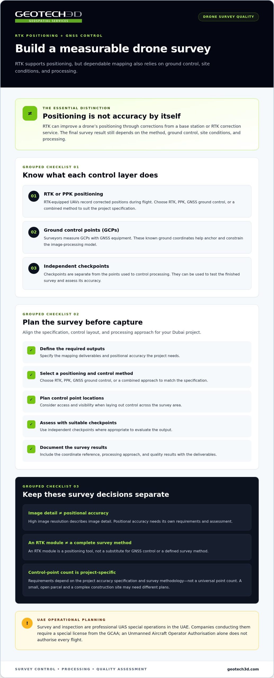
RTK improves a drone’s positioning by receiving corrections from a base station or RTK correction service. This supports mapping, but does not establish survey accuracy by itself. The method, ground control, site conditions, and processing all affect the final result. For a construction site, connect the required accuracy to the control strategy before capture begins.
A non-RTK workflow generally uses ground control points when higher positional accuracy is required. Surveyors measure these points with GNSS equipment, then use them to anchor the image-processing model to known ground coordinates. RTK-equipped UAVs record corrected positions during flight. Combining RTK or PPK positioning with suitable ground control can improve accuracy for mapping and measurement.
Separate control points from checkpoints
Ground control points help orient and constrain the model. Independent checkpoints serve a different purpose: they test the finished survey against locations not used to control processing. Ask whether checkpoints suit the project and how the results will be reported. This distinction matters on a Dubai development site, where engineering teams need to judge whether mapped features support design or construction decisions.
Equipment choice should follow the required deliverable. The DJI Mavic 3 Enterprise can be equipped with an RTK module for precision surveying. An RTK module is a positioning tool, not a substitute for GNSS control or a defined survey method. Likewise, high image resolution describes image detail, not positional accuracy. Each requirement needs its own acceptance criteria.
Before capture, align the survey specification, control layout, and processing approach. A practical sequence is:
- Define the required mapping outputs and positional accuracy.
- Select RTK, PPK, GNSS ground control, or a combined method to suit the specification.
- Plan control points across the survey area, considering access and visibility.
- Use suitable independent checkpoints to assess output accuracy.
- Document coordinate reference, processing, and quality results with the deliverables.
Control requirements depend on project accuracy specifications and survey methodology, not a universal point count. A small, open parcel and a complex construction site may need different control plans. With suitable survey control and processing, drone data can produce measurable mapping outputs. For projects that also require established site mapping, a topo survey can complement the drone workflow.
Need a Professional Drone Survey or Inspection?
Aerial data is useful only when its accuracy suits the decisions it needs to support. Assess the survey method, positioning, control, site conditions, and processing together.
Drone Survey Accuracy Factors
Accuracy depends on the capture method, positioning system, ground control, site conditions, and processing workflow. For a topographic survey, uneven terrain, limited access, or obscured ground can affect which features appear in aerial imagery. A professional drone team should link its planned method to the required measurements and explain how field conditions may affect the final mapping outputs.
Camera detail and positional accuracy are separate considerations. High-resolution imagery can show small visible features, but image resolution alone does not establish their surveyed coordinates. For example, a sharp image of a site boundary still needs appropriate positioning and control before it can support reliable measurement.
Accuracy Verification
Verification compares processed survey data with independent checkpoints where appropriate. These points are not used to control the model, so their results provide a separate assessment of positional performance. The project specification and survey method determine whether checkpoints are suitable and how to distribute them across the mapped area.
Review reported results alongside the deliverable. A topographic output for design coordination may need different assessment criteria from an overview image for progress review. Clear documentation should identify the survey method, coordinate reference, processing approach, and verification findings.
GPS Accuracy
GPS supports aircraft positioning, but recorded locations are only one part of survey accuracy. RTK or PPK positioning can be combined with GNSS control points, photogrammetry, or LiDAR, depending on the mapping requirements. Site conditions and processing also affect final positions, so consider GPS data as part of the complete survey workflow.
Ask how the positioning approach meets the project’s accuracy specification. For example, a construction team measuring earthworks needs outputs tied to suitable survey control, not just sharp-looking aerial images. Resolution describes image detail; it does not replace positional verification.
Inspection has a related but distinct purpose. Drone imagery can show rooftops and façades, helping identify visible damage or areas for further investigation. It does not replace specialist structural inspection. A useful report presents findings, recommendations, and relevant information in a format suited to the client’s requirements.
Before approving a workflow, align these practical checks:
- Match the survey method and sensor to the required topographic or inspection output.
- Relate GNSS or RTK positioning to ground control and the project specification.
- Use independent checkpoints where appropriate to assess survey accuracy.
- Ensure processing and reporting describe the results in a usable context.
Flight stability and image consistency
Consistent flight paths and camera settings help produce imagery that can be compared across a site or survey visit. For insurance, safety, and data security, assess whether the provider has coverage relevant to the planned operation, a site-specific safety plan, and clear controls for data access, storage, transfer, and retention.
Survey and inspection operations in the UAE fall within professional UAS special operations. An Unmanned Aircraft Operator Authorisation alone does not authorise every flight. Plan permissions for the specific site and operation before scheduling capture, and coordinate the flight plan with the site team, especially around active construction or industrial areas.
Plan repeatable capture
Flight stability helps maintain consistent image scale, overlap, and coverage. The survey team should plan the route, altitude, speed, camera angle, and exposure around the required output. For example, repeated passes over an excavation make progress imagery easier to compare when the capture method stays consistent. Changes in light, wind, or site access may require adjustments.
Control points also need to remain visible in captured imagery when they are part of the survey workflow. Coordinate their placement with the planned flight lines, then review sample images for blur, gaps, and adequate overlap. These checks can reveal capture problems before processing and help prevent avoidable rework.
Coordinate safety and site access
A site-specific plan should identify the launch and landing area, active work zones, nearby obstacles, and communication steps with site personnel. On a construction project, coordinate capture with crane operations, vehicle routes, and workers on the ground. Define how the flight will pause or change if site activity or conditions affect safe operation.
Review insurance in relation to the operation, aircraft, payload, and site exposure. Safety documentation should explain the flight plan, hazard controls, crew responsibilities, and response steps. For data security, establish who can access captured imagery, where files are stored, how they are transferred, and when they will be retained or removed.
Account for flight time
Flight time affects how a team divides coverage into missions. Payload, route length, site conditions, and planned image overlap all influence the capture plan. A large industrial site may require multiple flights, while a compact roof inspection may need a different route and image sequence.
Allow time for setup, control-point checks, image review, and any required repeat capture. A well-planned sequence can make fieldwork more efficient by reducing missed areas and avoidable return visits. Evaluate the proposed schedule against coverage and deliverable requirements, not aircraft flight time alone.
Survey provider expertise and project specialization
Assess whether the provider’s surveying methods, project experience, and deliverables fit your site and engineering use. Drone mapping outputs can include orthomosaics, point clouds, 3D models, surface or terrain models, contour data, and stockpile volumes. Agree on the required outputs and file formats in the project scope so the delivered data fits your team’s workflow.
Provider Expertise and Track Record
Look for experience with the specific work, not just a general claim of drone capability. A provider handling construction progress mapping should understand repeat capture and earthwork measurement; an industrial inspection requires relevant image-capture and reporting expertise. Review examples, methods, and explanations of precision and quality review for comparable work.
Assess reputation through specific evidence. Project examples should explain the application, outputs, and intended use. A clear account of photogrammetry, processing, and quality review can show whether a team understands the full survey workflow, not just the flight.
Relevant Dubai Project Experience
Dubai sites vary in access, surrounding structures, active construction, and coordination needs. Compare a provider’s experience with similar projects, such as infrastructure development, highway or bridge construction, urban planning, industrial asset monitoring, or large-scale earthworks. Relevant project knowledge helps shape data capture and deliver outputs suited to engineering decisions.
Connect the proposed workflow to your intended use. Site grading may require elevation and contour information, while progress tracking benefits from repeatable mapping and comparable outputs. Project examples can show how survey data supports cut-and-fill analysis, layout verification, or as-built documentation.
Project scale and delivery time depend on area, detail, capture requirements, and processing. Smaller residential land surveys can be completed within 1-2 days, while larger or more detailed projects may take several weeks. Set milestones for planning, field capture, processing, review, and handover so the schedule reflects the full scope.
Define deliverables before work starts. An orthomosaic, for example, can provide site context, while a point cloud supports detailed spatial review. Specify the coordinate reference, resolution, coverage, and whether the team must provide contours, measurements, or volume calculations. Agree on file formats that fit the project team’s GIS or CAD workflow.
A quotation should itemize coverage, equipment or sensor requirements, control and verification, processing, deliverables, and any repeat capture. Project costs depend on these scope factors and are provided after a quote request. Compare proposals based on the work and outputs included, not headline cost alone.
GEOTECH 3D: topo survey
GEOTECH 3D provides topo survey and Drone Services for projects that need mapped site conditions, aerial data, or survey outputs for engineering decisions. A topo survey can support site planning and terrain assessment, while drone-based data capture can document areas such as earthworks and construction progress.
For projects requiring additional spatial context, GIS & Surveying Services can help organize and use geospatial information. The right scope depends on the site, required measurements, and intended deliverables. Share those details when you’re ready to discuss a Dubai survey or inspection.
Contact GEOTECH 3D to discuss your project requirements: visit geotech3d.com.
Move from Survey Requirements to a Clear Project Scope
When choosing a drone survey provider in Dubai, start with the decisions your data needs to support. Define the site, intended use, required outputs, and how the project team will apply them. This gives the survey scope a practical foundation and helps align field capture with engineering needs.
GEOTECH 3D offers Drone Services and topo survey for projects requiring aerial data or mapped site conditions. Where existing assets need detailed spatial documentation, 3D Laser Scanning can support a broader reality-capture workflow. The right combination depends on the site and the outputs your team needs.
Share your project requirements with GEOTECH 3D to discuss a suitable surveying approach.
A clearly defined scope is a strong starting point for confident project decisions.
Frequently Asked Questions
Do commercial drone operators need approval in the UAE?
Yes. Survey and inspection operations require a special license from the GCAA. Distinguish the company’s operating credentials from the permissions required for a specific flight. Before mobilization, establish the site, purpose, planned capture area, and schedule so the operation can be planned appropriately. A valid operator authorisation alone does not settle every flight’s requirements.
How do I choose a drone survey company in the UAE?
Choose a company whose survey approach fits your intended use and whose scope defines the outputs, review process, and handover. For example, a contractor tracking earthworks needs data that supports comparison and measurement, while an asset owner may need inspection imagery and findings. Clarify who will use the results, how they will be delivered, and which decisions they need to support before comparing proposals.
What licenses and permits must a drone survey provider have in Dubai?
For survey or inspection operations, companies require a special GCAA license, and an operator authorisation alone does not authorise every flight. The project plan should account for the particular site and operation, rather than treating one credential as universal permission. Identify approval responsibilities and flight-planning steps in the project scope before agreeing on fieldwork dates.
Which Dubai authorities regulate commercial drone surveying and aerial photography?
The GCAA is the authority identified for the special license required for companies conducting drone survey or inspection operations in the UAE. Surveying and aerial photography can serve different purposes, so describe the planned activity accurately in the flight plan. Do not assume permission for one operation automatically covers another; plan according to the operation and site.
What qualifications and experience should a drone survey team have?
Look for a team that can explain its survey method, processing workflow, quality review, and technical personnel’s roles. Relevant experience should match the intended work: construction progress monitoring, for example, differs from documenting an industrial asset. Review sample deliverables and ask how the team organizes field capture, analysis, and reporting so your engineers can use the information effectively.
What drone survey services are available in Dubai, such as mapping, LiDAR, and photogrammetry?
Drone survey services can produce orthomosaics, point clouds, 3D models, digital surface models, and digital elevation models. Photogrammetry uses aerial imagery to create mapping outputs, while LiDAR can support terrain and vegetation mapping. The suitable method depends on the target features and required results. For example, stockpile volume work needs a 3D representation that supports measurement, rather than imagery alone.
How accurate are drone survey deliverables, and what accuracy specifications should clients request?
Accuracy varies with the method, positioning, control, site conditions, and processing. Define acceptance criteria around the intended use, including the required coordinate reference and horizontal or vertical tolerances. Ask how results will be evaluated and whether independent checkpoints are suitable. For engineering work, request verification information with the deliverables so project teams can judge whether they meet the task’s requirements.
How much does a drone survey cost in Dubai, and what affects the price?
The cost depends on the project scope and is provided after a quote request. Factors include the site area, access, sensor and positioning approach, control requirements, processing, verification, and requested deliverables. A quotation should make clear what work and outputs are included. For example, a request for a measured 3D model has a different scope from a request for an aerial overview.

The drone itself is only one part of a reliable survey. To understand how to choose a drone survey provider in Dubai, assess its RTK positioning, GNSS ground control, repeatable flight planning, project-specific expertise, and ability to deliver the mapping or inspection outputs you need. In the UAE, survey and inspection are professional UAS special operations, and an Unmanned Aircraft Operator Authorisation does not by itself authorise every flight.
For construction, infrastructure, and asset teams, usable results depend on more than clear aerial imagery. The survey method, positioning, control, site conditions, and processing all influence whether captured data can support measurement and decision-making. This guide explains how to assess RTK systems and GNSS control, what consistent flight execution looks like, and how to match provider expertise and deliverables to your Dubai project. It also clarifies where drone imagery can inform an inspection and where specialist assessment is still needed.
Key Takeaways
- Match the aircraft, sensor payload, and processing workflow to the survey output your project needs, rather than selecting equipment by name alone.
- Assess how RTK positioning and GNSS ground control work together to support dependable, measurable mapping data.
- Look for repeatable flight planning and consistent image capture to make site comparisons more useful over time.
- Choose a provider whose surveying and inspection expertise aligns with your site conditions, project sector, and required deliverables.
- GEOTECH 3D’s topo survey and drone services can support Dubai projects that need mapped site conditions and geospatial data.
Looking for Reliable Drone Surveying Services UAE?
Choose the drone and sensor configuration to suit the required mapping output, site conditions, and measurement task. A compact multirotor may suit a confined Dubai plot, while a larger mapping area may call for a different aircraft and payload. The aircraft model alone does not show whether the resulting data will meet the project’s needs.
For land, excavation, and earthworks mapping, define the areas and decisions the survey must support. Drone imagery can document excavation extents, stockpiles, earthworks, access routes, boundaries, and visible site features. Processed data can include orthomosaics, point clouds, 3D models, digital surface models, and digital elevation models. A stockpile model, for example, can support volume calculation.
Compact mapping drones can suit smaller sites with restricted launch areas or closely spaced structures. Assess camera quality, flight time, positioning, and software compatibility together. RGB cameras support photogrammetric mapping, while LiDAR can be useful for terrain and vegetation mapping. Choose the sensor based on what needs to be measured, not just how the site looks.
Match the aircraft to the mapping task
The DJI Matrice 4E is described as a portable surveying and mapping platform. For larger projects, compare the aircraft and payload as a combined system. A camera-based workflow may suit visible surface mapping; a LiDAR payload can suit terrain or vegetation requirements. The correct method depends on coverage, detail, surface conditions, and the intended deliverable.
VTOL and fixed-wing platforms offer different approaches to mapping. A VTOL aircraft can take off and land vertically, which may help where a runway is impractical. Fixed-wing aircraft stay airborne by moving forward and can suit broad-area coverage when the site allows for launch and recovery. Compare operating space, terrain, planned coverage, and sensor requirements before choosing a platform.
- For a compact urban site, prioritize a manageable launch area, image quality, and usable overlap between captures.
- For extensive earthworks, assess coverage efficiency, payload suitability, and whether repeat surveys can use a consistent method.
- For terrain beneath vegetation, consider whether LiDAR is appropriate; for photogrammetric mapping, assess the RGB camera workflow.
In the UAE, survey and inspection fall within professional UAS special operations, and companies conducting them require a special license from the GCAA. An Unmanned Aircraft Operator Authorisation alone does not authorise every flight. Include operational requirements in project planning alongside the aircraft, payload, processing method, and measurement outputs.
RTK-enabled UAV systems and GNSS control points
RTK improves a drone’s positioning by receiving corrections from a base station or RTK correction service. This supports mapping, but does not establish survey accuracy by itself. The method, ground control, site conditions, and processing all affect the final result. For a construction site, connect the required accuracy to the control strategy before capture begins.
A non-RTK workflow generally uses ground control points when higher positional accuracy is required. Surveyors measure these points with GNSS equipment, then use them to anchor the image-processing model to known ground coordinates. RTK-equipped UAVs record corrected positions during flight. Combining RTK or PPK positioning with suitable ground control can improve accuracy for mapping and measurement.
Separate control points from checkpoints
Ground control points help orient and constrain the model. Independent checkpoints serve a different purpose: they test the finished survey against locations not used to control processing. Ask whether checkpoints suit the project and how the results will be reported. This distinction matters on a Dubai development site, where engineering teams need to judge whether mapped features support design or construction decisions.
Equipment choice should follow the required deliverable. The DJI Mavic 3 Enterprise can be equipped with an RTK module for precision surveying. An RTK module is a positioning tool, not a substitute for GNSS control or a defined survey method. Likewise, high image resolution describes image detail, not positional accuracy. Each requirement needs its own acceptance criteria.
Before capture, align the survey specification, control layout, and processing approach. A practical sequence is:
- Define the required mapping outputs and positional accuracy.
- Select RTK, PPK, GNSS ground control, or a combined method to suit the specification.
- Plan control points across the survey area, considering access and visibility.
- Use suitable independent checkpoints to assess output accuracy.
- Document coordinate reference, processing, and quality results with the deliverables.
Control requirements depend on project accuracy specifications and survey methodology, not a universal point count. A small, open parcel and a complex construction site may need different control plans. With suitable survey control and processing, drone data can produce measurable mapping outputs. For projects that also require established site mapping, a topo survey can complement the drone workflow.
Need a Professional Drone Survey or Inspection?
Aerial data is useful only when its accuracy suits the decisions it needs to support. Assess the survey method, positioning, control, site conditions, and processing together.
Drone Survey Accuracy Factors
Accuracy depends on the capture method, positioning system, ground control, site conditions, and processing workflow. For a topographic survey, uneven terrain, limited access, or obscured ground can affect which features appear in aerial imagery. A professional drone team should link its planned method to the required measurements and explain how field conditions may affect the final mapping outputs.
Camera detail and positional accuracy are separate considerations. High-resolution imagery can show small visible features, but image resolution alone does not establish their surveyed coordinates. For example, a sharp image of a site boundary still needs appropriate positioning and control before it can support reliable measurement.
Accuracy Verification
Verification compares processed survey data with independent checkpoints where appropriate. These points are not used to control the model, so their results provide a separate assessment of positional performance. The project specification and survey method determine whether checkpoints are suitable and how to distribute them across the mapped area.
Review reported results alongside the deliverable. A topographic output for design coordination may need different assessment criteria from an overview image for progress review. Clear documentation should identify the survey method, coordinate reference, processing approach, and verification findings.
GPS Accuracy
GPS supports aircraft positioning, but recorded locations are only one part of survey accuracy. RTK or PPK positioning can be combined with GNSS control points, photogrammetry, or LiDAR, depending on the mapping requirements. Site conditions and processing also affect final positions, so consider GPS data as part of the complete survey workflow.
Ask how the positioning approach meets the project’s accuracy specification. For example, a construction team measuring earthworks needs outputs tied to suitable survey control, not just sharp-looking aerial images. Resolution describes image detail; it does not replace positional verification.
Inspection has a related but distinct purpose. Drone imagery can show rooftops and façades, helping identify visible damage or areas for further investigation. It does not replace specialist structural inspection. A useful report presents findings, recommendations, and relevant information in a format suited to the client’s requirements.
Before approving a workflow, align these practical checks:
- Match the survey method and sensor to the required topographic or inspection output.
- Relate GNSS or RTK positioning to ground control and the project specification.
- Use independent checkpoints where appropriate to assess survey accuracy.
- Ensure processing and reporting describe the results in a usable context.
Flight stability and image consistency
Consistent flight paths and camera settings help produce imagery that can be compared across a site or survey visit. For insurance, safety, and data security, assess whether the provider has coverage relevant to the planned operation, a site-specific safety plan, and clear controls for data access, storage, transfer, and retention.
Survey and inspection operations in the UAE fall within professional UAS special operations. An Unmanned Aircraft Operator Authorisation alone does not authorise every flight. Plan permissions for the specific site and operation before scheduling capture, and coordinate the flight plan with the site team, especially around active construction or industrial areas.
Plan repeatable capture
Flight stability helps maintain consistent image scale, overlap, and coverage. The survey team should plan the route, altitude, speed, camera angle, and exposure around the required output. For example, repeated passes over an excavation make progress imagery easier to compare when the capture method stays consistent. Changes in light, wind, or site access may require adjustments.
Control points also need to remain visible in captured imagery when they are part of the survey workflow. Coordinate their placement with the planned flight lines, then review sample images for blur, gaps, and adequate overlap. These checks can reveal capture problems before processing and help prevent avoidable rework.
Coordinate safety and site access
A site-specific plan should identify the launch and landing area, active work zones, nearby obstacles, and communication steps with site personnel. On a construction project, coordinate capture with crane operations, vehicle routes, and workers on the ground. Define how the flight will pause or change if site activity or conditions affect safe operation.
Review insurance in relation to the operation, aircraft, payload, and site exposure. Safety documentation should explain the flight plan, hazard controls, crew responsibilities, and response steps. For data security, establish who can access captured imagery, where files are stored, how they are transferred, and when they will be retained or removed.
Account for flight time
Flight time affects how a team divides coverage into missions. Payload, route length, site conditions, and planned image overlap all influence the capture plan. A large industrial site may require multiple flights, while a compact roof inspection may need a different route and image sequence.
Allow time for setup, control-point checks, image review, and any required repeat capture. A well-planned sequence can make fieldwork more efficient by reducing missed areas and avoidable return visits. Evaluate the proposed schedule against coverage and deliverable requirements, not aircraft flight time alone.
Survey provider expertise and project specialization
Assess whether the provider’s surveying methods, project experience, and deliverables fit your site and engineering use. Drone mapping outputs can include orthomosaics, point clouds, 3D models, surface or terrain models, contour data, and stockpile volumes. Agree on the required outputs and file formats in the project scope so the delivered data fits your team’s workflow.
Provider Expertise and Track Record
Look for experience with the specific work, not just a general claim of drone capability. A provider handling construction progress mapping should understand repeat capture and earthwork measurement; an industrial inspection requires relevant image-capture and reporting expertise. Review examples, methods, and explanations of precision and quality review for comparable work.
Assess reputation through specific evidence. Project examples should explain the application, outputs, and intended use. A clear account of photogrammetry, processing, and quality review can show whether a team understands the full survey workflow, not just the flight.
Relevant Dubai Project Experience
Dubai sites vary in access, surrounding structures, active construction, and coordination needs. Compare a provider’s experience with similar projects, such as infrastructure development, highway or bridge construction, urban planning, industrial asset monitoring, or large-scale earthworks. Relevant project knowledge helps shape data capture and deliver outputs suited to engineering decisions.
Connect the proposed workflow to your intended use. Site grading may require elevation and contour information, while progress tracking benefits from repeatable mapping and comparable outputs. Project examples can show how survey data supports cut-and-fill analysis, layout verification, or as-built documentation.
Project scale and delivery time depend on area, detail, capture requirements, and processing. Smaller residential land surveys can be completed within 1-2 days, while larger or more detailed projects may take several weeks. Set milestones for planning, field capture, processing, review, and handover so the schedule reflects the full scope.
Define deliverables before work starts. An orthomosaic, for example, can provide site context, while a point cloud supports detailed spatial review. Specify the coordinate reference, resolution, coverage, and whether the team must provide contours, measurements, or volume calculations. Agree on file formats that fit the project team’s GIS or CAD workflow.
A quotation should itemize coverage, equipment or sensor requirements, control and verification, processing, deliverables, and any repeat capture. Project costs depend on these scope factors and are provided after a quote request. Compare proposals based on the work and outputs included, not headline cost alone.
GEOTECH 3D: topo survey
GEOTECH 3D provides topo survey and Drone Services for projects that need mapped site conditions, aerial data, or survey outputs for engineering decisions. A topo survey can support site planning and terrain assessment, while drone-based data capture can document areas such as earthworks and construction progress.
For projects requiring additional spatial context, GIS & Surveying Services can help organize and use geospatial information. The right scope depends on the site, required measurements, and intended deliverables. Share those details when you’re ready to discuss a Dubai survey or inspection.
Contact GEOTECH 3D to discuss your project requirements: visit geotech3d.com.
Move from Survey Requirements to a Clear Project Scope
When choosing a drone survey provider in Dubai, start with the decisions your data needs to support. Define the site, intended use, required outputs, and how the project team will apply them. This gives the survey scope a practical foundation and helps align field capture with engineering needs.
GEOTECH 3D offers Drone Services and topo survey for projects requiring aerial data or mapped site conditions. Where existing assets need detailed spatial documentation, 3D Laser Scanning can support a broader reality-capture workflow. The right combination depends on the site and the outputs your team needs.
Share your project requirements with GEOTECH 3D to discuss a suitable surveying approach.
A clearly defined scope is a strong starting point for confident project decisions.
Frequently Asked Questions
Do commercial drone operators need approval in the UAE?
Yes. Survey and inspection operations require a special license from the GCAA. Distinguish the company’s operating credentials from the permissions required for a specific flight. Before mobilization, establish the site, purpose, planned capture area, and schedule so the operation can be planned appropriately. A valid operator authorisation alone does not settle every flight’s requirements.
How do I choose a drone survey company in the UAE?
Choose a company whose survey approach fits your intended use and whose scope defines the outputs, review process, and handover. For example, a contractor tracking earthworks needs data that supports comparison and measurement, while an asset owner may need inspection imagery and findings. Clarify who will use the results, how they will be delivered, and which decisions they need to support before comparing proposals.
What licenses and permits must a drone survey provider have in Dubai?
For survey or inspection operations, companies require a special GCAA license, and an operator authorisation alone does not authorise every flight. The project plan should account for the particular site and operation, rather than treating one credential as universal permission. Identify approval responsibilities and flight-planning steps in the project scope before agreeing on fieldwork dates.
Which Dubai authorities regulate commercial drone surveying and aerial photography?
The GCAA is the authority identified for the special license required for companies conducting drone survey or inspection operations in the UAE. Surveying and aerial photography can serve different purposes, so describe the planned activity accurately in the flight plan. Do not assume permission for one operation automatically covers another; plan according to the operation and site.
What qualifications and experience should a drone survey team have?
Look for a team that can explain its survey method, processing workflow, quality review, and technical personnel’s roles. Relevant experience should match the intended work: construction progress monitoring, for example, differs from documenting an industrial asset. Review sample deliverables and ask how the team organizes field capture, analysis, and reporting so your engineers can use the information effectively.
What drone survey services are available in Dubai, such as mapping, LiDAR, and photogrammetry?
Drone survey services can produce orthomosaics, point clouds, 3D models, digital surface models, and digital elevation models. Photogrammetry uses aerial imagery to create mapping outputs, while LiDAR can support terrain and vegetation mapping. The suitable method depends on the target features and required results. For example, stockpile volume work needs a 3D representation that supports measurement, rather than imagery alone.
How accurate are drone survey deliverables, and what accuracy specifications should clients request?
Accuracy varies with the method, positioning, control, site conditions, and processing. Define acceptance criteria around the intended use, including the required coordinate reference and horizontal or vertical tolerances. Ask how results will be evaluated and whether independent checkpoints are suitable. For engineering work, request verification information with the deliverables so project teams can judge whether they meet the task’s requirements.
How much does a drone survey cost in Dubai, and what affects the price?
The cost depends on the project scope and is provided after a quote request. Factors include the site area, access, sensor and positioning approach, control requirements, processing, verification, and requested deliverables. A quotation should make clear what work and outputs are included. For example, a request for a measured 3D model has a different scope from a request for an aerial overview.
Search Now
Error: Contact form not found.