

Our Services
GIS Mapping Services in Dubai: From Field Data to Better Decisions
In Dubai and across the UAE, GIS mapping services bring survey and other geospatial information together to help project teams understand site conditions, assets and spatial relationships. The practical value depends on asking the right question first: what does your team need to locate, compare or plan?
A survey file alone may not show how site features relate to a boundary, where mapped utilities sit in relation to proposed work, or which information needs further review. Effective mapping connects relevant data collection with usable maps and Spatial Analysis, shaped around the decisions developers, contractors, engineers and asset owners need to make.
This article explains what GIS mapping services can deliver, how geospatial data supports UAE projects, and how to scope work around operational needs. It compares topographic, cadastral and utility mapping, and explains how survey and other geospatial capabilities contribute to a broader spatial picture. You’ll also learn how GEOTECH 3D’s GIS & Surveying Services and Geoverse Platform can support project and asset-management decisions.
Key Takeaways
- Start with the decision your team needs to make, then identify the spatial information that can help inform it.
- GIS mapping services organize location-based information so teams can interpret site features, assets, boundaries and surrounding conditions together.
- Choose a mapping scope to fit the question: land, terrain, structures, utilities and volumes call for different project focuses.
- Define the project area, relevant assets and intended use. Gather available plans and survey records to help establish a clear scope.
- GEOTECH 3D’s GIS & Surveying Services bring mapping, survey and Spatial Analysis capabilities to projects in Dubai and across the UAE.
What GIS Mapping Services Deliver for Dubai and UAE Projects
GIS mapping services organize location-based data into maps and spatial information that teams can use to understand a project area and inform operational decisions. By connecting information to its location, GIS helps teams interpret site features, boundaries, assets and surrounding conditions together instead of reviewing disconnected records. For a broader overview of the technology, see What is a Geographic Information System (GIS)?
GIS software provides tools for storing, viewing and analyzing spatial data. A mapping service applies relevant data and methods to a defined project need, such as representing terrain, organizing land information or mapping utilities. The scope and outputs depend on the project question. Before work begins, establish which features matter, what information is available and how the team intends to use the result.
How GIS mapping differs from a static map
A static map presents information in a fixed view. GIS can organize separate spatial layers so teams can examine how survey observations, boundaries, assets and site features relate. For example, a Dubai development team might need to consider proposed work in relation to the site boundary, existing features and nearby mapped assets. Bringing relevant layers into a shared spatial context can make those relationships easier to review. The usefulness of that view depends on the quality, coverage and suitability of the underlying data.
Before selecting layers, define the decision the mapping should support. Is the team assessing site conditions, reviewing asset locations or comparing features across an area? Then identify what source information is available and whether it is suitable for that purpose. Gaps, inconsistent references or limited coverage can affect what the team can responsibly interpret. A detailed map does not resolve uncertainty in its source data.
Who uses GIS mapping in the UAE?
Different organizations use spatial information to answer different operational questions. In the UAE, relevant users include government bodies, utilities and infrastructure owners, developers, engineering and construction firms, oil and gas operations, and mining operations. The information they need varies by role and project phase:
- Developers and project managers may use site boundaries, existing features and surrounding conditions to support planning and coordination.
- Contractors and engineers may use mapped survey observations or asset locations to inform work planning and project coordination.
- Utilities and infrastructure owners may review mapped asset locations in relation to sites and other features.
- Government and operations teams may use spatial analysis to interpret geographic patterns relevant to planning or asset management.
- Mining operations may use survey information to understand site conditions and volumes in their geographic context.
These examples describe decision contexts, not a standard set of deliverables. GEOTECH 3D’s GIS & Surveying Services bring mapping, survey and Spatial Analysis capabilities together around project needs. Define the scope according to the question, the information available and how the resulting spatial data will be used.
How GIS Mapping Services Turn Survey Data into Spatial Insight
A useful mapping workflow starts with the decision, not the data source. For a Dubai site, the question might concern ground features, land boundaries, a structure or the location of an asset. That question guides which information is needed, how it may be captured or assembled, and what mapping or analysis is relevant. This keeps data collection tied to intended use instead of gathering information without a defined purpose.
From project question to mapped information
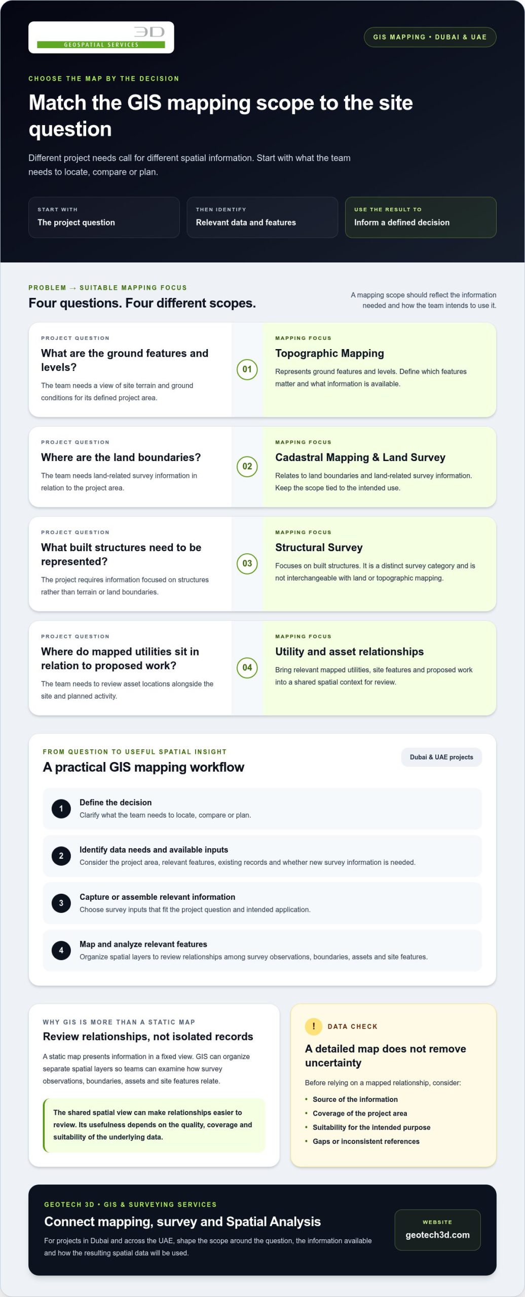
A practical sequence is to define the question, identify the data needs, capture or assemble relevant information, map it, then analyze the mapped features. Existing records may contribute, or new survey information may be needed. To establish the right approach, consider the project area, available inputs and intended use. GEOTECH 3D’s GIS & Surveying Services connect survey and mapping capabilities with Spatial Analysis.
Reliable spatial inputs matter because analysis can only be as useful as the information it uses. Before relying on a mapped relationship for planning or operations, understand the source, coverage and limitations of the data. The U.S. government’s authoritative geospatial data platform illustrates the role organized, authoritative information can play in geospatial work, though it is not a UAE data source.
Choosing relevant survey and data-capture methods
Different project questions call for different survey inputs. Topographic Mapping can represent ground features and levels. Cadastral Mapping and Land Survey relate to land boundaries and land-related survey information, while Structural Survey focuses on built structures. These categories are not interchangeable, and a project may need one or more depending on its scope. Digital Photogrammetry Services and Aerial Inspection are also documented capabilities. Their relevance depends on the site, the information required and the intended application.
When planning GIS mapping services, make the connection between method and purpose explicit. Identify what needs to be represented, what information is already available and how the mapped material will be used. This helps align field data and existing records with project questions, without assuming a single acquisition method suits every site or asset.
From mapped layers to Spatial Analysis
Once relevant information is organized spatially, Spatial Analysis can help examine relationships among features. A team might review an asset’s position relative to a site boundary or compare mapped features with surrounding conditions. These are ways to frame an analysis, not guaranteed findings. The outcome depends on the inputs and the scope defined for the work.
Underground assets require care when information is interpreted alongside other site data. Utility Mapping (GPR) is a GEOTECH 3D service for utility mapping needs. For projects involving subsurface assets, define how utility information should relate to the wider mapped context and which decisions the information needs to support. The workflow should connect the collected information to a practical project purpose.
GIS Mapping Services Compared: Match the Method to the Project Need
The right mapping scope depends on the question a project needs to answer. A team assessing terrain has a different requirement from one organizing property information, mapping underground assets or measuring a mining volume. GIS mapping services organize relevant information for a defined purpose, but the service category alone does not determine every data source or collection method.
Separate the question from the method. “Where are the site features in relation to the boundary?” is a project question. Topographic or cadastral information may be relevant, depending on the scope and available data. How the information is captured, assembled or analyzed is a separate decision, influenced by site access, existing records and intended use.
| Project question | Relevant service category | Typical purpose |
|---|---|---|
| What terrain and site features need to be represented? | Topographic Mapping | Describe terrain context and mapped site features for project understanding. |
| How should land or property information be represented spatially? | Cadastral Mapping | Organize land and property information in a mapped context. Mapping alone does not establish legal effect. |
| What land-related survey information is needed? | Land Survey | Support project teams working with land-related survey data. |
| Where may underground assets be located? | Utility Mapping (GPR) | Address project needs involving underground-asset mapping. |
| What information about a structure is relevant? | Structural Survey | Focus survey work on built structures and their project context. |
| What volume-related information does a mining operation need? | Volumetric Mining Surveys | Address volumetric survey needs in mining operations. |
| What water catchment conditions need to be surveyed? | Water Catchment Survey | Focus the survey scope on a water catchment area. |
Topographic, cadastral, and land mapping
Topographic Mapping is relevant when teams need terrain and site features represented for planning or site interpretation. Cadastral Mapping relates to land and property information, while Land Survey supports projects requiring land-related survey data. These categories can contribute to a project’s spatial picture, but they do not serve identical purposes. Define the information required and how it will be used before deciding which scope fits.
Utility, infrastructure, and industry mapping
Utility Mapping (GPR) is relevant when a project needs underground-asset mapping. For context on how mapped assets may contribute to longer-term planning and management, see the related guide to digital twins. Volumetric Mining Surveys and Water Catchment Survey address distinct operational needs, rather than serving as general substitutes for site or utility mapping.
Available records, site access and the decision the information must support all affect scope and method. The kinds of spatial information represented in GIS data from the U.S. Geological Survey also illustrate how data sources can vary. It is a reference, not a UAE project dataset. GEOTECH 3D’s mapping and survey capabilities can be matched to a project’s specific question and intended use.
How to Scope GIS Mapping Services for a Dubai Project
A clear scope connects fieldwork and mapped information to the decisions a Dubai project needs to make. Start with the operational or planning question, then define the geographic area, identify the assets or features involved, and state how the information will be used. This gives the mapping brief a practical focus and helps distinguish essential data from information that does not support the intended decision.
Define the project question and required coverage
Describe the area to be considered, relevant site boundaries or assets, and the teams that will use the information. A developer may need site context for planning, while an asset owner may be focused on mapped asset locations. State the decision clearly, then define the coverage needed to inform it. Let the project requirements guide the scope rather than assuming a standard area or output.
Existing project information is an important starting point. Gather available plans, survey records and other relevant data, and note their source and intended use if known. This helps the team identify which information can contribute and where additional data collection may be relevant. GEOTECH 3D’s GIS & Surveying Services can be scoped around defined project needs, rather than treating every service category as necessary for every site.
Align data collection with project constraints
Site access, safety requirements, stakeholder coordination, existing records and schedule constraints can influence how work is planned. Record these conditions early. If renovation decisions depend on understanding existing built conditions, 3D Scanning may be relevant as a reality-capture input. Consider it in relation to the specific project question and how the resulting information will be used.
Use the brief to connect project constraints to the required survey or mapping scope. A project focused on terrain may call for Topographic Mapping, while a question about underground assets may point toward Utility Mapping (GPR). These are examples of scope alignment, not a fixed package. The appropriate combination depends on the area, available information, access and intended decisions.
Before mapping begins, make sure the project brief answers these questions:
- What operational, planning or asset-management decision must the mapped information support?
- What geographic area, boundaries, assets or site features should the scope cover?
- Which teams or stakeholders will use the information, and for what purpose?
- What plans, survey records and other relevant project data are available?
- What access, safety, coordination or schedule constraints could affect data collection?
- What information is needed from the work, and how will it be used?
GIS mapping services are easier to scope when the brief makes the intended decision and project constraints explicit. This gives survey and mapping work a clear basis and keeps the selected methods relevant to the project, without assuming a particular delivery format or completion time.
GEOTECH 3D GIS & Surveying Services for UAE Projects
GEOTECH 3D provides GIS & Surveying Services in Dubai and across the UAE. Its capabilities include mapping, survey and Spatial Analysis, with scopes selected around project requirements. A development site, utility network and mining operation present different questions, so define the work for its intended use rather than treating it as a standard bundle.
For project teams, GIS mapping services connect field and survey information with a spatial view that can inform planning and asset decisions. GEOTECH 3D emphasizes accurate data collection, strict safety compliance and meeting tight schedules. The scope is shaped by project requirements, available information and site conditions.
GIS services for development, infrastructure, and industry
Different sectors call for different mapping and survey applications. Cadastral Mapping can support government needs involving mapped land and property information. Utility Mapping (GPR) is relevant to infrastructure owners working with underground-asset mapping. For construction and real estate, Topographic Mapping, Land Survey or Structural Survey may be appropriate depending on whether the question concerns terrain, land-related information or built structures.
Industrial requirements vary as well. GEOTECH 3D’s documented scopes include Oil & Gas Surveys and Volumetric Mining Surveys, each addressing a distinct sector context. A project brief can identify the area, assets and decisions that matter, then align the mapping and survey work accordingly. This avoids assuming that every developer, contractor, consultant or asset owner needs the same data collection or analysis.
Connecting GIS mapping with digital-twin applications
Spatial Analysis can help teams examine relationships among mapped features. In digital-twin applications, this spatial context can contribute to City Modeling and Smart Cities Management, where geographic information supports the representation and management of urban environments. The Geoverse Platform supports city-scale modeling, smart-city management and spatial analysis. These capabilities serve broader spatial applications, but not every project needs a digital twin.
For an asset owner, mapped information may be considered alongside longer-term asset-management needs. For a development team, the focus may be the spatial context needed for a specific planning decision. In either case, start with a clearly defined question and scope that reflects the intended use, stakeholders and relevant project data.
Explore GEOTECH 3D’s GIS and surveying capabilities to see how mapping and survey work can support your project requirements.
Turn Your Mapping Scope into a Clear Next Step
Strong spatial decisions begin with a brief that connects the information required to the way your team will use it. Align project stakeholders on the key question, the area of interest and the decisions the work needs to inform. This shared direction keeps GIS mapping services focused on practical project needs.
For teams in Dubai and across the UAE, a well-defined scope also creates a clearer basis for coordinating survey information, analysis and operational priorities. GEOTECH 3D brings a safety-focused approach to its geospatial services and offers GIS & Surveying Services and digital-twin capabilities, from project-specific mapping to city-scale modeling and smart-city management through the Geoverse Platform.
Bring your project question, relevant records and site constraints into the conversation. These details give the team a practical starting point for defining a mapping scope around your next decision.
With a clear purpose guiding the work, your team can move from data collection to a more useful spatial view.
Frequently Asked Questions
What does GIS mapping include?
GIS mapping can include mapped survey information, organized spatial layers and analysis selected for a project’s purpose. A team might bring survey observations together with asset or boundary information, or review how features relate across a site. GEOTECH 3D’s GIS & Surveying Services include mapping, surveying and Spatial Analysis. The scope depends on the information required and how the project team intends to use it.
Can GIS mapping show underground utilities in Dubai?
Yes. Utility Mapping (GPR) is a GEOTECH 3D service for projects in Dubai that need underground-asset mapping. The resulting information can be considered alongside other mapped site data during planning or coordination. Scope the work around the project area and intended use, and interpret the results in the context of the information gathered. Existing utility records can also provide useful context when planning the mapping work.
How accurate is GIS mapping?
There is no single accuracy value that applies to every GIS mapping project. Reliability depends on the source data, survey approach, coverage, and how information is assembled and interpreted. Before using a mapped layer for design coordination or asset decisions, review its source and available metadata, including coordinate reference information and survey details. Consider the level of detail needed in relation to the decision the mapping must support.
What is the difference between GIS mapping and topographic mapping?
Topographic Mapping focuses on representing terrain and relevant site features. GIS mapping is broader: it can organize multiple kinds of location-based information and support analysis of their spatial relationships. Topographic information may contribute to a wider GIS view, but the terms do not describe identical scopes. For a Dubai site, the distinction depends on whether the requirement is terrain representation, broader data integration or both.
Can GIS mapping support construction and infrastructure planning?
Yes. GIS mapping can help construction and infrastructure teams view site information and assets in relation to boundaries, surrounding features or other project data. This spatial context can inform planning discussions, coordination and review. For example, a team planning work near mapped utilities can consider those locations alongside other site information. The value depends on the relevance and quality of the data, not simply on having a map.
Can GIS mapping data be used in a digital twin?
GIS mapping data can contribute to a digital-twin application when it suits the model’s purpose and can be integrated appropriately. GEOTECH 3D’s digital-twin work includes City Modeling, Smart Cities Management and the Geoverse Platform, which supports city-scale modeling, smart-city management and spatial analysis. Before incorporating mapping data, consider its source, coverage and intended role in the digital environment.
What information should I prepare before requesting GIS mapping services?
Prepare available site or boundary plans, previous survey records, utility information and relevant asset registers. Note the project location, intended use of the mapped information and which teams need to work with it. If known, include coordinate reference details and explain access or site-safety constraints. These materials help establish what information is already available and provide useful context for defining GIS mapping services around your project.

In Dubai and across the UAE, GIS mapping services bring survey and other geospatial information together to help project teams understand site conditions, assets and spatial relationships. The practical value depends on asking the right question first: what does your team need to locate, compare or plan?
A survey file alone may not show how site features relate to a boundary, where mapped utilities sit in relation to proposed work, or which information needs further review. Effective mapping connects relevant data collection with usable maps and Spatial Analysis, shaped around the decisions developers, contractors, engineers and asset owners need to make.
This article explains what GIS mapping services can deliver, how geospatial data supports UAE projects, and how to scope work around operational needs. It compares topographic, cadastral and utility mapping, and explains how survey and other geospatial capabilities contribute to a broader spatial picture. You’ll also learn how GEOTECH 3D’s GIS & Surveying Services and Geoverse Platform can support project and asset-management decisions.
Key Takeaways
- Start with the decision your team needs to make, then identify the spatial information that can help inform it.
- GIS mapping services organize location-based information so teams can interpret site features, assets, boundaries and surrounding conditions together.
- Choose a mapping scope to fit the question: land, terrain, structures, utilities and volumes call for different project focuses.
- Define the project area, relevant assets and intended use. Gather available plans and survey records to help establish a clear scope.
- GEOTECH 3D’s GIS & Surveying Services bring mapping, survey and Spatial Analysis capabilities to projects in Dubai and across the UAE.
What GIS Mapping Services Deliver for Dubai and UAE Projects
GIS mapping services organize location-based data into maps and spatial information that teams can use to understand a project area and inform operational decisions. By connecting information to its location, GIS helps teams interpret site features, boundaries, assets and surrounding conditions together instead of reviewing disconnected records. For a broader overview of the technology, see What is a Geographic Information System (GIS)?
GIS software provides tools for storing, viewing and analyzing spatial data. A mapping service applies relevant data and methods to a defined project need, such as representing terrain, organizing land information or mapping utilities. The scope and outputs depend on the project question. Before work begins, establish which features matter, what information is available and how the team intends to use the result.
How GIS mapping differs from a static map
A static map presents information in a fixed view. GIS can organize separate spatial layers so teams can examine how survey observations, boundaries, assets and site features relate. For example, a Dubai development team might need to consider proposed work in relation to the site boundary, existing features and nearby mapped assets. Bringing relevant layers into a shared spatial context can make those relationships easier to review. The usefulness of that view depends on the quality, coverage and suitability of the underlying data.
Before selecting layers, define the decision the mapping should support. Is the team assessing site conditions, reviewing asset locations or comparing features across an area? Then identify what source information is available and whether it is suitable for that purpose. Gaps, inconsistent references or limited coverage can affect what the team can responsibly interpret. A detailed map does not resolve uncertainty in its source data.
Who uses GIS mapping in the UAE?
Different organizations use spatial information to answer different operational questions. In the UAE, relevant users include government bodies, utilities and infrastructure owners, developers, engineering and construction firms, oil and gas operations, and mining operations. The information they need varies by role and project phase:
- Developers and project managers may use site boundaries, existing features and surrounding conditions to support planning and coordination.
- Contractors and engineers may use mapped survey observations or asset locations to inform work planning and project coordination.
- Utilities and infrastructure owners may review mapped asset locations in relation to sites and other features.
- Government and operations teams may use spatial analysis to interpret geographic patterns relevant to planning or asset management.
- Mining operations may use survey information to understand site conditions and volumes in their geographic context.
These examples describe decision contexts, not a standard set of deliverables. GEOTECH 3D’s GIS & Surveying Services bring mapping, survey and Spatial Analysis capabilities together around project needs. Define the scope according to the question, the information available and how the resulting spatial data will be used.
How GIS Mapping Services Turn Survey Data into Spatial Insight
A useful mapping workflow starts with the decision, not the data source. For a Dubai site, the question might concern ground features, land boundaries, a structure or the location of an asset. That question guides which information is needed, how it may be captured or assembled, and what mapping or analysis is relevant. This keeps data collection tied to intended use instead of gathering information without a defined purpose.
From project question to mapped information
A practical sequence is to define the question, identify the data needs, capture or assemble relevant information, map it, then analyze the mapped features. Existing records may contribute, or new survey information may be needed. To establish the right approach, consider the project area, available inputs and intended use. GEOTECH 3D’s GIS & Surveying Services connect survey and mapping capabilities with Spatial Analysis.
Reliable spatial inputs matter because analysis can only be as useful as the information it uses. Before relying on a mapped relationship for planning or operations, understand the source, coverage and limitations of the data. The U.S. government’s authoritative geospatial data platform illustrates the role organized, authoritative information can play in geospatial work, though it is not a UAE data source.
Choosing relevant survey and data-capture methods
Different project questions call for different survey inputs. Topographic Mapping can represent ground features and levels. Cadastral Mapping and Land Survey relate to land boundaries and land-related survey information, while Structural Survey focuses on built structures. These categories are not interchangeable, and a project may need one or more depending on its scope. Digital Photogrammetry Services and Aerial Inspection are also documented capabilities. Their relevance depends on the site, the information required and the intended application.
When planning GIS mapping services, make the connection between method and purpose explicit. Identify what needs to be represented, what information is already available and how the mapped material will be used. This helps align field data and existing records with project questions, without assuming a single acquisition method suits every site or asset.
From mapped layers to Spatial Analysis
Once relevant information is organized spatially, Spatial Analysis can help examine relationships among features. A team might review an asset’s position relative to a site boundary or compare mapped features with surrounding conditions. These are ways to frame an analysis, not guaranteed findings. The outcome depends on the inputs and the scope defined for the work.
Underground assets require care when information is interpreted alongside other site data. Utility Mapping (GPR) is a GEOTECH 3D service for utility mapping needs. For projects involving subsurface assets, define how utility information should relate to the wider mapped context and which decisions the information needs to support. The workflow should connect the collected information to a practical project purpose.
GIS Mapping Services Compared: Match the Method to the Project Need
The right mapping scope depends on the question a project needs to answer. A team assessing terrain has a different requirement from one organizing property information, mapping underground assets or measuring a mining volume. GIS mapping services organize relevant information for a defined purpose, but the service category alone does not determine every data source or collection method.
Separate the question from the method. “Where are the site features in relation to the boundary?” is a project question. Topographic or cadastral information may be relevant, depending on the scope and available data. How the information is captured, assembled or analyzed is a separate decision, influenced by site access, existing records and intended use.
| Project question | Relevant service category | Typical purpose |
|---|---|---|
| What terrain and site features need to be represented? | Topographic Mapping | Describe terrain context and mapped site features for project understanding. |
| How should land or property information be represented spatially? | Cadastral Mapping | Organize land and property information in a mapped context. Mapping alone does not establish legal effect. |
| What land-related survey information is needed? | Land Survey | Support project teams working with land-related survey data. |
| Where may underground assets be located? | Utility Mapping (GPR) | Address project needs involving underground-asset mapping. |
| What information about a structure is relevant? | Structural Survey | Focus survey work on built structures and their project context. |
| What volume-related information does a mining operation need? | Volumetric Mining Surveys | Address volumetric survey needs in mining operations. |
| What water catchment conditions need to be surveyed? | Water Catchment Survey | Focus the survey scope on a water catchment area. |
Topographic, cadastral, and land mapping
Topographic Mapping is relevant when teams need terrain and site features represented for planning or site interpretation. Cadastral Mapping relates to land and property information, while Land Survey supports projects requiring land-related survey data. These categories can contribute to a project’s spatial picture, but they do not serve identical purposes. Define the information required and how it will be used before deciding which scope fits.
Utility, infrastructure, and industry mapping
Utility Mapping (GPR) is relevant when a project needs underground-asset mapping. For context on how mapped assets may contribute to longer-term planning and management, see the related guide to digital twins. Volumetric Mining Surveys and Water Catchment Survey address distinct operational needs, rather than serving as general substitutes for site or utility mapping.
Available records, site access and the decision the information must support all affect scope and method. The kinds of spatial information represented in GIS data from the U.S. Geological Survey also illustrate how data sources can vary. It is a reference, not a UAE project dataset. GEOTECH 3D’s mapping and survey capabilities can be matched to a project’s specific question and intended use.
How to Scope GIS Mapping Services for a Dubai Project
A clear scope connects fieldwork and mapped information to the decisions a Dubai project needs to make. Start with the operational or planning question, then define the geographic area, identify the assets or features involved, and state how the information will be used. This gives the mapping brief a practical focus and helps distinguish essential data from information that does not support the intended decision.
Define the project question and required coverage
Describe the area to be considered, relevant site boundaries or assets, and the teams that will use the information. A developer may need site context for planning, while an asset owner may be focused on mapped asset locations. State the decision clearly, then define the coverage needed to inform it. Let the project requirements guide the scope rather than assuming a standard area or output.
Existing project information is an important starting point. Gather available plans, survey records and other relevant data, and note their source and intended use if known. This helps the team identify which information can contribute and where additional data collection may be relevant. GEOTECH 3D’s GIS & Surveying Services can be scoped around defined project needs, rather than treating every service category as necessary for every site.
Align data collection with project constraints
Site access, safety requirements, stakeholder coordination, existing records and schedule constraints can influence how work is planned. Record these conditions early. If renovation decisions depend on understanding existing built conditions, 3D Scanning may be relevant as a reality-capture input. Consider it in relation to the specific project question and how the resulting information will be used.
Use the brief to connect project constraints to the required survey or mapping scope. A project focused on terrain may call for Topographic Mapping, while a question about underground assets may point toward Utility Mapping (GPR). These are examples of scope alignment, not a fixed package. The appropriate combination depends on the area, available information, access and intended decisions.
Before mapping begins, make sure the project brief answers these questions:
- What operational, planning or asset-management decision must the mapped information support?
- What geographic area, boundaries, assets or site features should the scope cover?
- Which teams or stakeholders will use the information, and for what purpose?
- What plans, survey records and other relevant project data are available?
- What access, safety, coordination or schedule constraints could affect data collection?
- What information is needed from the work, and how will it be used?
GIS mapping services are easier to scope when the brief makes the intended decision and project constraints explicit. This gives survey and mapping work a clear basis and keeps the selected methods relevant to the project, without assuming a particular delivery format or completion time.
GEOTECH 3D GIS & Surveying Services for UAE Projects
GEOTECH 3D provides GIS & Surveying Services in Dubai and across the UAE. Its capabilities include mapping, survey and Spatial Analysis, with scopes selected around project requirements. A development site, utility network and mining operation present different questions, so define the work for its intended use rather than treating it as a standard bundle.
For project teams, GIS mapping services connect field and survey information with a spatial view that can inform planning and asset decisions. GEOTECH 3D emphasizes accurate data collection, strict safety compliance and meeting tight schedules. The scope is shaped by project requirements, available information and site conditions.
GIS services for development, infrastructure, and industry
Different sectors call for different mapping and survey applications. Cadastral Mapping can support government needs involving mapped land and property information. Utility Mapping (GPR) is relevant to infrastructure owners working with underground-asset mapping. For construction and real estate, Topographic Mapping, Land Survey or Structural Survey may be appropriate depending on whether the question concerns terrain, land-related information or built structures.
Industrial requirements vary as well. GEOTECH 3D’s documented scopes include Oil & Gas Surveys and Volumetric Mining Surveys, each addressing a distinct sector context. A project brief can identify the area, assets and decisions that matter, then align the mapping and survey work accordingly. This avoids assuming that every developer, contractor, consultant or asset owner needs the same data collection or analysis.
Connecting GIS mapping with digital-twin applications
Spatial Analysis can help teams examine relationships among mapped features. In digital-twin applications, this spatial context can contribute to City Modeling and Smart Cities Management, where geographic information supports the representation and management of urban environments. The Geoverse Platform supports city-scale modeling, smart-city management and spatial analysis. These capabilities serve broader spatial applications, but not every project needs a digital twin.
For an asset owner, mapped information may be considered alongside longer-term asset-management needs. For a development team, the focus may be the spatial context needed for a specific planning decision. In either case, start with a clearly defined question and scope that reflects the intended use, stakeholders and relevant project data.
Explore GEOTECH 3D’s GIS and surveying capabilities to see how mapping and survey work can support your project requirements.
Turn Your Mapping Scope into a Clear Next Step
Strong spatial decisions begin with a brief that connects the information required to the way your team will use it. Align project stakeholders on the key question, the area of interest and the decisions the work needs to inform. This shared direction keeps GIS mapping services focused on practical project needs.
For teams in Dubai and across the UAE, a well-defined scope also creates a clearer basis for coordinating survey information, analysis and operational priorities. GEOTECH 3D brings a safety-focused approach to its geospatial services and offers GIS & Surveying Services and digital-twin capabilities, from project-specific mapping to city-scale modeling and smart-city management through the Geoverse Platform.
Bring your project question, relevant records and site constraints into the conversation. These details give the team a practical starting point for defining a mapping scope around your next decision.
With a clear purpose guiding the work, your team can move from data collection to a more useful spatial view.
Frequently Asked Questions
What does GIS mapping include?
GIS mapping can include mapped survey information, organized spatial layers and analysis selected for a project’s purpose. A team might bring survey observations together with asset or boundary information, or review how features relate across a site. GEOTECH 3D’s GIS & Surveying Services include mapping, surveying and Spatial Analysis. The scope depends on the information required and how the project team intends to use it.
Can GIS mapping show underground utilities in Dubai?
Yes. Utility Mapping (GPR) is a GEOTECH 3D service for projects in Dubai that need underground-asset mapping. The resulting information can be considered alongside other mapped site data during planning or coordination. Scope the work around the project area and intended use, and interpret the results in the context of the information gathered. Existing utility records can also provide useful context when planning the mapping work.
How accurate is GIS mapping?
There is no single accuracy value that applies to every GIS mapping project. Reliability depends on the source data, survey approach, coverage, and how information is assembled and interpreted. Before using a mapped layer for design coordination or asset decisions, review its source and available metadata, including coordinate reference information and survey details. Consider the level of detail needed in relation to the decision the mapping must support.
What is the difference between GIS mapping and topographic mapping?
Topographic Mapping focuses on representing terrain and relevant site features. GIS mapping is broader: it can organize multiple kinds of location-based information and support analysis of their spatial relationships. Topographic information may contribute to a wider GIS view, but the terms do not describe identical scopes. For a Dubai site, the distinction depends on whether the requirement is terrain representation, broader data integration or both.
Can GIS mapping support construction and infrastructure planning?
Yes. GIS mapping can help construction and infrastructure teams view site information and assets in relation to boundaries, surrounding features or other project data. This spatial context can inform planning discussions, coordination and review. For example, a team planning work near mapped utilities can consider those locations alongside other site information. The value depends on the relevance and quality of the data, not simply on having a map.
Can GIS mapping data be used in a digital twin?
GIS mapping data can contribute to a digital-twin application when it suits the model’s purpose and can be integrated appropriately. GEOTECH 3D’s digital-twin work includes City Modeling, Smart Cities Management and the Geoverse Platform, which supports city-scale modeling, smart-city management and spatial analysis. Before incorporating mapping data, consider its source, coverage and intended role in the digital environment.
What information should I prepare before requesting GIS mapping services?
Prepare available site or boundary plans, previous survey records, utility information and relevant asset registers. Note the project location, intended use of the mapped information and which teams need to work with it. If known, include coordinate reference details and explain access or site-safety constraints. These materials help establish what information is already available and provide useful context for defining GIS mapping services around your project.
Search Now
Error: Contact form not found.