

Our Services
GPR Utility Locating Services Dubai: The 2026 Professional Buying Guide
A utility strike can turn a planned excavation into a safety incident, a shutdown, and an avoidable delay. The right GPR survey can reduce uncertainty, but no locating method can guarantee that every buried service will be found.
Choosing GPR utility locating services Dubai project teams can rely on means looking beyond equipment. You need clear interpretation of subsurface data, practical site plans, attention to project requirements, and deliverables that fit your digital workflow. This 2026 guide explains how to assess those technical and commercial criteria, and what to ask before appointing a survey partner.
GEOTECH 3D provides Utility Mapping (GPR) as part of its GIS and surveying services. When project requirements call for it, survey information can be coordinated with Scan-to-BIM or GEOVERSE Digital Twin workflows. With offices in Dubai and Abu Dhabi, GEOTECH 3D brings utility mapping together with broader geospatial capabilities. The sections ahead cover data quality, reporting, digital integration, and regulatory considerations to help you compare providers.
Key Takeaways
- Assess GPR utility locating services Dubai providers by the clarity of their interpretation and the usefulness of their mapped deliverables, not equipment alone.
- Understand how GPR and radio frequency locating differ, then choose an approach suited to the utilities and site conditions being investigated.
- Use existing utility drawings as a reference, then verify site conditions before excavation rather than assuming legacy records are complete.
- Check whether survey data can support your next workflow, including GIS, Scan-to-BIM, or integration with the GEOVERSE Digital Twin.
- Use the buyer’s checklist to compare relevant project experience, technical reporting, and how a provider addresses your requirements.
The Strategic Importance of GPR Utility Locating Services in Dubai
Below Dubai’s roads, plots, and active construction sites is a dense network of power, water, telecom, and cooling infrastructure. Ground-penetrating radar (GPR) is a non-destructive investigation method that sends electromagnetic pulses into the ground and records returning signals from buried features. It can help survey teams locate and map potential utilities before excavation. For a general overview of the technology and its applications, see Ground-penetrating radar (GPR).
Existing “as-built” drawings are useful references, but may not fully represent current site conditions. Infrastructure can change as developments expand, and records may differ in age, detail, or positional accuracy. Treat drawings as records to check, not confirmed ground truth. Field investigation helps teams compare available information with subsurface evidence.
Mitigating Risk in High-Density Urban Environments
DEWA networks, telecom lines, district cooling pipes, and other buried assets can occupy the same constrained corridors. GPR responds to changes in underground material properties, so it can help identify metallic and non-metallic features, including plastic pipes and ducts that may contain fibre-optic cables. Results depend on ground conditions, target depth and spacing, and survey execution. Interpretation should distinguish detected features from confirmed utility identity.
The commercial case is risk reduction, not certainty. A strike can cause asset damage, work stoppages, safety exposure, and knock-on delays. Investigation and clear mapping before excavation can help teams plan around potential conflicts and reduce the likelihood of surprises. Subsurface Utility Engineering (SUE) brings records, field investigation, data interpretation, and documentation into a coordinated process for project decisions.
Regulatory and Safety Compliance
Utility mapping can provide information to support excavation planning and project submissions, including NOC processes where applicable. Requirements depend on the work location and relevant authority or asset owner. Confirm the current submission criteria for each project rather than assuming a GPR survey alone secures approval.
Knowing where potential services lie helps site teams define safer excavation zones and communicate hazards to ground personnel. It also supports protection of nearby infrastructure and the surrounding community. GPR should form part of a broader safe-work process, alongside current records, project controls, and appropriate verification before intrusive work.
For 2026 projects, utility mapping can inform more than immediate excavation. Structured, accurately referenced data may support GIS records, Scan-to-BIM workflows, and smart infrastructure management. GEOTECH 3D provides Utility Mapping (GPR) within its GIS and surveying services. Where project scope and data requirements align, subsurface information can be coordinated with BIM-ready models or the GEOVERSE Digital Twin. The company has offices in Dubai and Abu Dhabi.
Technical Evaluation: How Precision GPR Locating Works
GPR works on a pulse-and-echo principle. An antenna sends short electromagnetic pulses into the ground. When they meet a boundary between materials with different electrical properties, some energy reflects back to the receiver. The instrument records returning signals as a radargram. These patterns can indicate buried features, but they do not identify every object conclusively or see through all ground conditions.
Survey quality depends on more than collecting radar data. The team must plan suitable survey lines, maintain consistent coverage, process the radargrams, and relate interpreted features to site coordinates and levels. Interpreters assess signal patterns alongside available utility records and site context, then translate findings into maps project teams can use. Clear reporting distinguishes interpreted features from confirmed information.
The Role of Antenna Frequency in Data Accuracy
Antenna frequency involves a trade-off between detail and penetration. Higher-frequency antennas generally provide finer detail for shallow targets, which may help map small ducts or service corridors. Lower-frequency antennas generally penetrate farther but provide less fine detail, and may be more appropriate when investigating larger or deeper features. Actual performance depends on ground conditions, target characteristics, survey setup, and equipment. A one-frequency approach may not suit a project that needs both shallow detail and greater penetration.
Beyond Detection: Depth and Material Identification
Radargrams show reflections and changes in signal response. An interpreter can assess patterns that may correspond to soil boundaries, voids, or buried structures, but GPR typically indicates an anomaly rather than confirming a pipe’s material or purpose. Findings should be presented with appropriate interpretation and limitations.
Dielectric constant describes how a material affects electromagnetic wave speed. An assumed or calibrated value is needed to convert GPR travel time into an estimated depth.
For horizontal directional drilling (HDD) planning, interpreted utility positions and estimated depths can help engineers review potential conflicts along a proposed alignment. Treat them as survey inputs, not standalone clearance or guarantees. Confirm project-specific verification requirements before drilling. For a risk-based framework, the Common Ground Alliance explains Subsurface Utility Engineering best practices.
When evaluating GPR utility locating services Dubai teams, ask how the provider selects antenna frequencies, documents uncertainty, georeferences interpreted features, and prepares data for downstream use. GEOTECH 3D provides Utility Mapping (GPR) and offers Scan-to-BIM services. Discuss the intended deliverables and workflow before commissioning a project. Explore GEOTECH 3D’s surveying services to see how subsurface mapping can fit into a broader geospatial workflow.
GPR vs. Traditional Utility Mapping: A 2026 Comparison
Radio frequency (RF) locators and ground-penetrating radar answer different survey questions. RF equipment detects electromagnetic signals associated with conductive pipes and cables, often through direct connection or induction. It can be practical for tracing a known, traceable service, but an unpowered or non-conductive asset may not provide a detectable signal. GPR records reflections from subsurface features, making it useful for investigating non-conductive materials such as PVC and HDPE, subject to site conditions and interpretation.
Neither method identifies every buried utility in every ground condition. In Dubai’s dense corridors, select a method based on target material, available access, site surface, and required deliverable. A coordinated survey may use one method or both, alongside records and other project information.
Efficiency and Data Reliability
RF locating typically gives an operator a changing audio or visual response as a signal is traced. GPR produces radargrams, visual records of reflected signals along survey lines. Those records can be reviewed and interpreted rather than relying only on marks made during fieldwork. A reflection is not automatically a confirmed utility, so the map should communicate interpretation and uncertainty clearly.
On a large development site, systematic data collection can help teams screen areas and focus further investigation where potential conflicts appear. GPR may reduce the need for exploratory trial pits or manual trenching, but it cannot replace verification where project risk or ground conditions call for it. Ask providers how they plan survey coverage, handle obstructions, and distinguish detected anomalies from identified assets.
Digital Integration and Archiving
Spray-paint marks can guide immediate site activity, but they are temporary and difficult to reuse as a lasting project record. A GIS-referenced utility map preserves interpreted locations in a coordinate framework and can support coordination with design information. Before commissioning the survey, confirm the required coordinate reference, file formats, feature attributes, and level of detail.
Digital records also provide a more useful starting point for future maintenance and asset management than undocumented field marks. Where a project needs a model-based workflow, utility data may be structured to support BIM coordination. GEOTECH 3D provides Utility Mapping (GPR) alongside Scan-to-BIM capabilities. Agree on the scope and format of any linked digital deliverables with the project team. Learn more about GEOTECH 3D’s GIS and surveying services.
For contractors comparing GPR utility locating services Dubai, the practical decision is not simply “GPR or RF.” It is whether the selected method can address the target utilities and produce a traceable, actionable record for excavation planning, coordination, and future use.
Hiring GPR Utility Locating Services in Dubai: A Buyer’s Checklist
Choosing a provider is a technical and commercial decision. GPR utility locating services Dubai projects need more than field data: they need interpretations and deliverables suited to the site, excavation plan, and downstream design workflow. Use these questions to compare providers on evidence, not promises.
- Local site experience: Ask how the team accounts for the ground conditions, surface constraints, and dense utility corridors on your project. Request relevant examples and clarify what the survey can and cannot detect.
- Qualified oversight: Confirm who plans the survey, interprets the data, and reviews the final map. Check professional registration or other credentials against your project requirements. Equipment operation alone does not demonstrate surveying expertise.
- Usable deliverables: Specify the coordinate reference system, drawing formats, feature attributes, and level of detail before work begins. Confirm that outputs will fit your CAD, GIS, or BIM workflow, and ask how uncertain or interpreted features will be identified.
- Safety readiness: For controlled or high-risk environments, ask for relevant safety documentation, site-specific method statements, and evidence of experience under similar access and safety requirements. Confirm facility-specific induction or approval processes with the asset owner.
- Schedule and coordination: Agree on survey boundaries, access dependencies, review stages, and delivery milestones. Ask for evidence of comparable UAE project coordination rather than relying on an unsupported promise of rapid mobilization.
Equipment and Technology Standards
Ask which GPR configurations and complementary sensors the provider proposes, and why they suit your target utilities and site conditions. A useful response should explain how acquisition settings and survey coverage will be selected, not simply list equipment. Ask which processing methods are used, who interprets the radar data, and how the final map is checked. Request sample outputs from a comparable environment, with sensitive project details removed if needed.
Team Expertise and Local Presence
Establish whether geospatial professionals lead survey planning and interpretation, and identify your technical point of contact. GEOTECH 3D provides Utility Mapping (GPR) within its GIS and surveying services. The company also serves the Oil & Gas sector, where strict safety requirements apply. Its offices are in Dubai and Abu Dhabi. Ask any prospective provider to substantiate relevant registrations, safety credentials, and schedule performance for your specific project.
Before appointing a provider, put acceptance criteria in writing: coverage limits, mapping conventions, file formats, coordinate requirements, and assumptions about site access. This creates a clear basis for reviewing the survey and integrating its results into the wider project workflow.
The GEOTECH 3D Advantage: Integrated Subsurface Solutions
For a construction or infrastructure team, utility detection is most useful when findings can inform design and asset planning. GEOTECH 3D combines Utility Mapping (GPR) with GIS and surveying capabilities, connecting subsurface data to digital workflows rather than leaving it only in a field report. The company has offices in Dubai and Abu Dhabi and serves projects across the UAE. It also works in the Oil & Gas sector, where safety requirements are strict.
This integrated approach is relevant to project owners planning beyond excavation. Properly structured subsurface information can contribute to coordinated models and digital records for infrastructure planning and smart city management. The value depends on clear data, defined project requirements, and appropriate interpretation, not simply placing a GPR scan inside a model.
From Raw Data to BIM-Ready Models
GPR acquisition produces interpreted subsurface findings that can be organized for downstream use. GEOTECH 3D offers Scan-to-BIM services that develop point cloud data into detailed Building Information Models. For a project combining utility information with a model-based workflow, agree on model scope, coordinate reference, feature classification, level of detail, and how interpreted or uncertain locations will be represented. These decisions help architects and engineers understand how underground constraints relate to above-ground design information.
When coordinated with suitable existing or newly captured building data, a model can bring above- and below-ground information into a shared project context. This can support design coordination and give teams a more useful record to consult as work progresses. For related capture workflows, see this guide to 3D laser scanning for renovation.
GEOVERSE Digital Twin for Utility Management
GEOTECH 3D’s GEOVERSE Digital Twin provides a digital environment for integrating suitable geospatial information. Subsurface utility data, when appropriately structured and maintained, can contribute to a broader view of infrastructure and support asset management. For city-scale management, source data quality and consistency matter: teams need to understand its coverage, reference system, interpretation, and currency before using it for planning.
As you evaluate GPR utility locating services Dubai providers, consider how well they connect field investigation, GIS deliverables, and BIM or digital twin requirements. GEOTECH 3D’s Utility Mapping (GPR) can be considered alongside its Scan-to-BIM and GEOVERSE Digital Twin services. Confirm project-specific safety credentials, team registrations, and deliverable requirements during procurement.
Build Your Next Project on Better Subsurface Data
In 2026, choosing GPR utility locating services Dubai projects can rely on means looking beyond detection. Prioritize clear, georeferenced deliverables that support design decisions, and confirm that the provider can prepare data for relevant GIS, Scan-to-BIM, or digital twin workflows.
GEOTECH 3D provides Utility Mapping (GPR) as part of its GIS and surveying services, alongside Scan-to-BIM and GEOVERSE Digital Twin capabilities. The company has offices in Dubai and Abu Dhabi. Its Dubai office is located at Ilyaa Tower 2 – Office 101, Damascus St., Al Qusais Industrial 3.
Thoughtful survey planning and usable digital records can help your team make more informed decisions from excavation planning through asset management. Discuss your project requirements and deliverables with GEOTECH 3D.
With suitable data and a capable project partner, your team can make better-informed decisions before work begins.
Frequently Asked Questions
What is the maximum depth GPR can reach in Dubai soil?
There is no single maximum depth that applies to every Dubai site. Penetration and the clarity of detected features depend on soil moisture and composition, target size and material, antenna frequency, and survey conditions. Ask the provider how they will assess the conditions on your site and describe the limitations of the results. Treat interpreted depths as estimates, not guaranteed limits.
Can GPR detect non-metallic pipes like PVC and HDPE?
Yes, GPR can help detect non-metallic pipes such as PVC and HDPE because it records reflections from changes in subsurface material properties, rather than relying only on a conductive pipe or cable. Detection and interpretation depend on factors such as pipe depth, size, surrounding soil, and survey setup. GPR results may indicate a buried feature, but they do not necessarily confirm its material or function without supporting records or verification.
Is GPR utility locating required for a Dubai Municipality NOC?
Do not assume that a GPR survey is a universal standalone requirement for every Dubai Municipality NOC. Submission and excavation requirements can vary by project, location, and relevant authority or asset owner. Confirm the current requirements for your specific site before commissioning survey work. GPR mapping may provide useful information for planning and project documentation, but completing a survey does not itself confirm NOC approval or replace other required submissions.
How long does a typical GPR utility survey take for a 1-hectare site?
A reliable duration cannot be determined from site area alone. Survey time depends on the required coverage and line spacing, surface access, obstructions, site activity, target complexity, and reporting or mapping deliverables. Processing and interpretation also take time beyond field acquisition. For a one-hectare site, provide the survey provider with a boundary plan, known utility records, access constraints, and required outputs, then request a project-specific schedule.
What is the difference between GPR and a standard cable locator?
A standard cable locator detects electromagnetic signals associated with conductive cables or pipes, often by applying or inducing a signal and tracing its response. GPR sends pulses into the ground and records reflections from subsurface contrasts, so it can help investigate non-conductive features as well. Each method has limitations. A locator may be effective for traceable conductive services, while GPR interpretation depends on ground conditions, target characteristics, and survey expertise.
Can GPR be used in areas with high electromagnetic interference?
GPR may be used in areas with electromagnetic interference, but interference can affect data quality and should be considered during survey planning. The impact depends on the source and level of noise, equipment, site conditions, and survey method. Ask the provider how they assess and document interference, whether a site test is appropriate, and how affected or uncertain data will be represented in the final utility map.
Does GEOTECH 3D provide BIM models of the detected utilities?
GEOTECH 3D provides Utility Mapping (GPR) and Scan-to-BIM services. Whether utility survey information is included in a BIM model depends on the agreed project scope and data requirements. Discuss coordinate reference, required file formats, model detail, and how interpreted features or uncertainty will be represented so the deliverable fits the design team’s workflow.
How accurate are GPR depth readings for excavation purposes?
GPR depth readings are estimates, not a guarantee of a utility’s exact depth. Depth calculation depends on signal travel time and the dielectric properties of the ground, which can vary across a site. Survey setup and interpretation also matter. For excavation planning, ask how depths are calibrated, referenced, and reported, and whether uncertainty is shown. Confirm project-specific verification requirements before intrusive work, especially where the consequences of a strike are high.
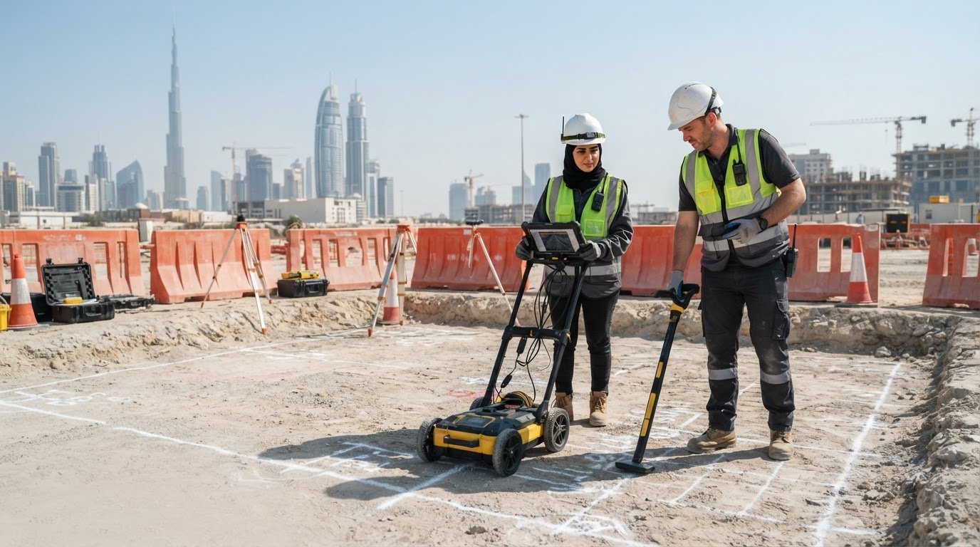
A utility strike can turn a planned excavation into a safety incident, a shutdown, and an avoidable delay. The right GPR survey can reduce uncertainty, but no locating method can guarantee that every buried service will be found.
Choosing GPR utility locating services Dubai project teams can rely on means looking beyond equipment. You need clear interpretation of subsurface data, practical site plans, attention to project requirements, and deliverables that fit your digital workflow. This 2026 guide explains how to assess those technical and commercial criteria, and what to ask before appointing a survey partner.
GEOTECH 3D provides Utility Mapping (GPR) as part of its GIS and surveying services. When project requirements call for it, survey information can be coordinated with Scan-to-BIM or GEOVERSE Digital Twin workflows. With offices in Dubai and Abu Dhabi, GEOTECH 3D brings utility mapping together with broader geospatial capabilities. The sections ahead cover data quality, reporting, digital integration, and regulatory considerations to help you compare providers.
Key Takeaways
- Assess GPR utility locating services Dubai providers by the clarity of their interpretation and the usefulness of their mapped deliverables, not equipment alone.
- Understand how GPR and radio frequency locating differ, then choose an approach suited to the utilities and site conditions being investigated.
- Use existing utility drawings as a reference, then verify site conditions before excavation rather than assuming legacy records are complete.
- Check whether survey data can support your next workflow, including GIS, Scan-to-BIM, or integration with the GEOVERSE Digital Twin.
- Use the buyer’s checklist to compare relevant project experience, technical reporting, and how a provider addresses your requirements.
The Strategic Importance of GPR Utility Locating Services in Dubai
Below Dubai’s roads, plots, and active construction sites is a dense network of power, water, telecom, and cooling infrastructure. Ground-penetrating radar (GPR) is a non-destructive investigation method that sends electromagnetic pulses into the ground and records returning signals from buried features. It can help survey teams locate and map potential utilities before excavation. For a general overview of the technology and its applications, see Ground-penetrating radar (GPR).
Existing “as-built” drawings are useful references, but may not fully represent current site conditions. Infrastructure can change as developments expand, and records may differ in age, detail, or positional accuracy. Treat drawings as records to check, not confirmed ground truth. Field investigation helps teams compare available information with subsurface evidence.
Mitigating Risk in High-Density Urban Environments
DEWA networks, telecom lines, district cooling pipes, and other buried assets can occupy the same constrained corridors. GPR responds to changes in underground material properties, so it can help identify metallic and non-metallic features, including plastic pipes and ducts that may contain fibre-optic cables. Results depend on ground conditions, target depth and spacing, and survey execution. Interpretation should distinguish detected features from confirmed utility identity.
The commercial case is risk reduction, not certainty. A strike can cause asset damage, work stoppages, safety exposure, and knock-on delays. Investigation and clear mapping before excavation can help teams plan around potential conflicts and reduce the likelihood of surprises. Subsurface Utility Engineering (SUE) brings records, field investigation, data interpretation, and documentation into a coordinated process for project decisions.
Regulatory and Safety Compliance
Utility mapping can provide information to support excavation planning and project submissions, including NOC processes where applicable. Requirements depend on the work location and relevant authority or asset owner. Confirm the current submission criteria for each project rather than assuming a GPR survey alone secures approval.
Knowing where potential services lie helps site teams define safer excavation zones and communicate hazards to ground personnel. It also supports protection of nearby infrastructure and the surrounding community. GPR should form part of a broader safe-work process, alongside current records, project controls, and appropriate verification before intrusive work.
For 2026 projects, utility mapping can inform more than immediate excavation. Structured, accurately referenced data may support GIS records, Scan-to-BIM workflows, and smart infrastructure management. GEOTECH 3D provides Utility Mapping (GPR) within its GIS and surveying services. Where project scope and data requirements align, subsurface information can be coordinated with BIM-ready models or the GEOVERSE Digital Twin. The company has offices in Dubai and Abu Dhabi.
Technical Evaluation: How Precision GPR Locating Works
GPR works on a pulse-and-echo principle. An antenna sends short electromagnetic pulses into the ground. When they meet a boundary between materials with different electrical properties, some energy reflects back to the receiver. The instrument records returning signals as a radargram. These patterns can indicate buried features, but they do not identify every object conclusively or see through all ground conditions.
Survey quality depends on more than collecting radar data. The team must plan suitable survey lines, maintain consistent coverage, process the radargrams, and relate interpreted features to site coordinates and levels. Interpreters assess signal patterns alongside available utility records and site context, then translate findings into maps project teams can use. Clear reporting distinguishes interpreted features from confirmed information.
The Role of Antenna Frequency in Data Accuracy
Antenna frequency involves a trade-off between detail and penetration. Higher-frequency antennas generally provide finer detail for shallow targets, which may help map small ducts or service corridors. Lower-frequency antennas generally penetrate farther but provide less fine detail, and may be more appropriate when investigating larger or deeper features. Actual performance depends on ground conditions, target characteristics, survey setup, and equipment. A one-frequency approach may not suit a project that needs both shallow detail and greater penetration.
Beyond Detection: Depth and Material Identification
Radargrams show reflections and changes in signal response. An interpreter can assess patterns that may correspond to soil boundaries, voids, or buried structures, but GPR typically indicates an anomaly rather than confirming a pipe’s material or purpose. Findings should be presented with appropriate interpretation and limitations.
Dielectric constant describes how a material affects electromagnetic wave speed. An assumed or calibrated value is needed to convert GPR travel time into an estimated depth.
For horizontal directional drilling (HDD) planning, interpreted utility positions and estimated depths can help engineers review potential conflicts along a proposed alignment. Treat them as survey inputs, not standalone clearance or guarantees. Confirm project-specific verification requirements before drilling. For a risk-based framework, the Common Ground Alliance explains Subsurface Utility Engineering best practices.
When evaluating GPR utility locating services Dubai teams, ask how the provider selects antenna frequencies, documents uncertainty, georeferences interpreted features, and prepares data for downstream use. GEOTECH 3D provides Utility Mapping (GPR) and offers Scan-to-BIM services. Discuss the intended deliverables and workflow before commissioning a project. Explore GEOTECH 3D’s surveying services to see how subsurface mapping can fit into a broader geospatial workflow.
GPR vs. Traditional Utility Mapping: A 2026 Comparison
Radio frequency (RF) locators and ground-penetrating radar answer different survey questions. RF equipment detects electromagnetic signals associated with conductive pipes and cables, often through direct connection or induction. It can be practical for tracing a known, traceable service, but an unpowered or non-conductive asset may not provide a detectable signal. GPR records reflections from subsurface features, making it useful for investigating non-conductive materials such as PVC and HDPE, subject to site conditions and interpretation.
Neither method identifies every buried utility in every ground condition. In Dubai’s dense corridors, select a method based on target material, available access, site surface, and required deliverable. A coordinated survey may use one method or both, alongside records and other project information.
Efficiency and Data Reliability
RF locating typically gives an operator a changing audio or visual response as a signal is traced. GPR produces radargrams, visual records of reflected signals along survey lines. Those records can be reviewed and interpreted rather than relying only on marks made during fieldwork. A reflection is not automatically a confirmed utility, so the map should communicate interpretation and uncertainty clearly.
On a large development site, systematic data collection can help teams screen areas and focus further investigation where potential conflicts appear. GPR may reduce the need for exploratory trial pits or manual trenching, but it cannot replace verification where project risk or ground conditions call for it. Ask providers how they plan survey coverage, handle obstructions, and distinguish detected anomalies from identified assets.
Digital Integration and Archiving
Spray-paint marks can guide immediate site activity, but they are temporary and difficult to reuse as a lasting project record. A GIS-referenced utility map preserves interpreted locations in a coordinate framework and can support coordination with design information. Before commissioning the survey, confirm the required coordinate reference, file formats, feature attributes, and level of detail.
Digital records also provide a more useful starting point for future maintenance and asset management than undocumented field marks. Where a project needs a model-based workflow, utility data may be structured to support BIM coordination. GEOTECH 3D provides Utility Mapping (GPR) alongside Scan-to-BIM capabilities. Agree on the scope and format of any linked digital deliverables with the project team. Learn more about GEOTECH 3D’s GIS and surveying services.
For contractors comparing GPR utility locating services Dubai, the practical decision is not simply “GPR or RF.” It is whether the selected method can address the target utilities and produce a traceable, actionable record for excavation planning, coordination, and future use.
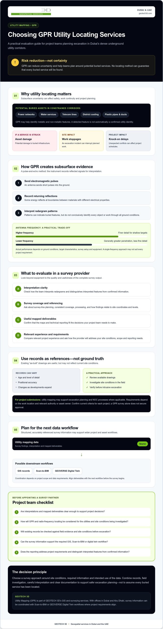
Hiring GPR Utility Locating Services in Dubai: A Buyer’s Checklist
Choosing a provider is a technical and commercial decision. GPR utility locating services Dubai projects need more than field data: they need interpretations and deliverables suited to the site, excavation plan, and downstream design workflow. Use these questions to compare providers on evidence, not promises.
- Local site experience: Ask how the team accounts for the ground conditions, surface constraints, and dense utility corridors on your project. Request relevant examples and clarify what the survey can and cannot detect.
- Qualified oversight: Confirm who plans the survey, interprets the data, and reviews the final map. Check professional registration or other credentials against your project requirements. Equipment operation alone does not demonstrate surveying expertise.
- Usable deliverables: Specify the coordinate reference system, drawing formats, feature attributes, and level of detail before work begins. Confirm that outputs will fit your CAD, GIS, or BIM workflow, and ask how uncertain or interpreted features will be identified.
- Safety readiness: For controlled or high-risk environments, ask for relevant safety documentation, site-specific method statements, and evidence of experience under similar access and safety requirements. Confirm facility-specific induction or approval processes with the asset owner.
- Schedule and coordination: Agree on survey boundaries, access dependencies, review stages, and delivery milestones. Ask for evidence of comparable UAE project coordination rather than relying on an unsupported promise of rapid mobilization.
Equipment and Technology Standards
Ask which GPR configurations and complementary sensors the provider proposes, and why they suit your target utilities and site conditions. A useful response should explain how acquisition settings and survey coverage will be selected, not simply list equipment. Ask which processing methods are used, who interprets the radar data, and how the final map is checked. Request sample outputs from a comparable environment, with sensitive project details removed if needed.
Team Expertise and Local Presence
Establish whether geospatial professionals lead survey planning and interpretation, and identify your technical point of contact. GEOTECH 3D provides Utility Mapping (GPR) within its GIS and surveying services. The company also serves the Oil & Gas sector, where strict safety requirements apply. Its offices are in Dubai and Abu Dhabi. Ask any prospective provider to substantiate relevant registrations, safety credentials, and schedule performance for your specific project.
Before appointing a provider, put acceptance criteria in writing: coverage limits, mapping conventions, file formats, coordinate requirements, and assumptions about site access. This creates a clear basis for reviewing the survey and integrating its results into the wider project workflow.
The GEOTECH 3D Advantage: Integrated Subsurface Solutions
For a construction or infrastructure team, utility detection is most useful when findings can inform design and asset planning. GEOTECH 3D combines Utility Mapping (GPR) with GIS and surveying capabilities, connecting subsurface data to digital workflows rather than leaving it only in a field report. The company has offices in Dubai and Abu Dhabi and serves projects across the UAE. It also works in the Oil & Gas sector, where safety requirements are strict.
This integrated approach is relevant to project owners planning beyond excavation. Properly structured subsurface information can contribute to coordinated models and digital records for infrastructure planning and smart city management. The value depends on clear data, defined project requirements, and appropriate interpretation, not simply placing a GPR scan inside a model.
From Raw Data to BIM-Ready Models
GPR acquisition produces interpreted subsurface findings that can be organized for downstream use. GEOTECH 3D offers Scan-to-BIM services that develop point cloud data into detailed Building Information Models. For a project combining utility information with a model-based workflow, agree on model scope, coordinate reference, feature classification, level of detail, and how interpreted or uncertain locations will be represented. These decisions help architects and engineers understand how underground constraints relate to above-ground design information.
When coordinated with suitable existing or newly captured building data, a model can bring above- and below-ground information into a shared project context. This can support design coordination and give teams a more useful record to consult as work progresses. For related capture workflows, see this guide to 3D laser scanning for renovation.
GEOVERSE Digital Twin for Utility Management
GEOTECH 3D’s GEOVERSE Digital Twin provides a digital environment for integrating suitable geospatial information. Subsurface utility data, when appropriately structured and maintained, can contribute to a broader view of infrastructure and support asset management. For city-scale management, source data quality and consistency matter: teams need to understand its coverage, reference system, interpretation, and currency before using it for planning.
As you evaluate GPR utility locating services Dubai providers, consider how well they connect field investigation, GIS deliverables, and BIM or digital twin requirements. GEOTECH 3D’s Utility Mapping (GPR) can be considered alongside its Scan-to-BIM and GEOVERSE Digital Twin services. Confirm project-specific safety credentials, team registrations, and deliverable requirements during procurement.
Build Your Next Project on Better Subsurface Data
In 2026, choosing GPR utility locating services Dubai projects can rely on means looking beyond detection. Prioritize clear, georeferenced deliverables that support design decisions, and confirm that the provider can prepare data for relevant GIS, Scan-to-BIM, or digital twin workflows.
GEOTECH 3D provides Utility Mapping (GPR) as part of its GIS and surveying services, alongside Scan-to-BIM and GEOVERSE Digital Twin capabilities. The company has offices in Dubai and Abu Dhabi. Its Dubai office is located at Ilyaa Tower 2 – Office 101, Damascus St., Al Qusais Industrial 3.
Thoughtful survey planning and usable digital records can help your team make more informed decisions from excavation planning through asset management. Discuss your project requirements and deliverables with GEOTECH 3D.
With suitable data and a capable project partner, your team can make better-informed decisions before work begins.
Frequently Asked Questions
What is the maximum depth GPR can reach in Dubai soil?
There is no single maximum depth that applies to every Dubai site. Penetration and the clarity of detected features depend on soil moisture and composition, target size and material, antenna frequency, and survey conditions. Ask the provider how they will assess the conditions on your site and describe the limitations of the results. Treat interpreted depths as estimates, not guaranteed limits.
Can GPR detect non-metallic pipes like PVC and HDPE?
Yes, GPR can help detect non-metallic pipes such as PVC and HDPE because it records reflections from changes in subsurface material properties, rather than relying only on a conductive pipe or cable. Detection and interpretation depend on factors such as pipe depth, size, surrounding soil, and survey setup. GPR results may indicate a buried feature, but they do not necessarily confirm its material or function without supporting records or verification.
Is GPR utility locating required for a Dubai Municipality NOC?
Do not assume that a GPR survey is a universal standalone requirement for every Dubai Municipality NOC. Submission and excavation requirements can vary by project, location, and relevant authority or asset owner. Confirm the current requirements for your specific site before commissioning survey work. GPR mapping may provide useful information for planning and project documentation, but completing a survey does not itself confirm NOC approval or replace other required submissions.
How long does a typical GPR utility survey take for a 1-hectare site?
A reliable duration cannot be determined from site area alone. Survey time depends on the required coverage and line spacing, surface access, obstructions, site activity, target complexity, and reporting or mapping deliverables. Processing and interpretation also take time beyond field acquisition. For a one-hectare site, provide the survey provider with a boundary plan, known utility records, access constraints, and required outputs, then request a project-specific schedule.
What is the difference between GPR and a standard cable locator?
A standard cable locator detects electromagnetic signals associated with conductive cables or pipes, often by applying or inducing a signal and tracing its response. GPR sends pulses into the ground and records reflections from subsurface contrasts, so it can help investigate non-conductive features as well. Each method has limitations. A locator may be effective for traceable conductive services, while GPR interpretation depends on ground conditions, target characteristics, and survey expertise.
Can GPR be used in areas with high electromagnetic interference?
GPR may be used in areas with electromagnetic interference, but interference can affect data quality and should be considered during survey planning. The impact depends on the source and level of noise, equipment, site conditions, and survey method. Ask the provider how they assess and document interference, whether a site test is appropriate, and how affected or uncertain data will be represented in the final utility map.
Does GEOTECH 3D provide BIM models of the detected utilities?
GEOTECH 3D provides Utility Mapping (GPR) and Scan-to-BIM services. Whether utility survey information is included in a BIM model depends on the agreed project scope and data requirements. Discuss coordinate reference, required file formats, model detail, and how interpreted features or uncertainty will be represented so the deliverable fits the design team’s workflow.
How accurate are GPR depth readings for excavation purposes?
GPR depth readings are estimates, not a guarantee of a utility’s exact depth. Depth calculation depends on signal travel time and the dielectric properties of the ground, which can vary across a site. Survey setup and interpretation also matter. For excavation planning, ask how depths are calibrated, referenced, and reported, and whether uncertainty is shown. Confirm project-specific verification requirements before intrusive work, especially where the consequences of a strike are high.
Search Now
Error: Contact form not found.