

Our Services
GPR Utility Scanning for Dubai Infrastructure (2026)
In 2026, a single utility strike in Dubai is no longer just a costly operational setback; it is a significant regulatory risk that can jeopardize your firm’s standing under the new Law No. 7 of 2025. With the Dubai Municipality now enforcing strict classification tiers and professional competency certifications, the margin for error in subsurface detection has effectively vanished. You’ve likely experienced the frustration of relying on inaccurate as-built drawings or struggling with signal attenuation in the UAE’s unique soil conditions. It is a challenge that demands more than just basic detection; it requires a sophisticated, data-driven approach to GPR utility scanning.
We understand that your primary objectives are to maintain project schedules, ensure site safety, and deliver high-fidelity 3D maps that integrate seamlessly into your BIM workflows. This article provides the technical expertise needed to master Ground Penetrating Radar nuances within the local landscape. You’ll learn how to eliminate utility strikes, achieve compliance with RTA and Dubai Municipality standards, and transform raw subsurface data into actionable assets for your digital twin. We’ll explore the latest methodologies for navigating Dubai’s complex infrastructure, ensuring your 2026 projects are built on a foundation of precision and verified intelligence.
Key Takeaways
- Understand how advanced subsurface mapping ensures compliance with the latest Dubai Municipality regulations and prevents costly project delays.
- Master the technical nuances of GPR utility scanning to overcome signal attenuation caused by the high soil salinity unique to the UAE’s coastal environments.
- Learn to distinguish between GPR and electromagnetic locating (EML) while applying SUE Quality Levels to achieve a higher standard of subsurface reliability.
- Discover how raw subsurface data is transformed into BIM-ready 3D models and integrated into the GEOVERSE Digital Twin platform for long-term asset management.
- Identify the strategic advantages of transitioning from traditional as-builts to accurate 3D documentation to eliminate utility strikes in 2026 infrastructure projects.
Navigating the Subsurface: The Critical Role of GPR Utility Scanning in Dubai
Dubai’s urban landscape is a marvel of engineering above ground, but the complexity beneath the surface is equally significant. As the city continues its rapid expansion in 2026, the density of underground assets has reached a point where traditional excavation methods carry unacceptable risks. Relying on historical as-built drawings is no longer a viable strategy; these records are frequently outdated or lack the precision required for modern piling and shoring operations. Professional GPR utility scanning has transitioned from a specialized service to a mandatory prerequisite for any project aiming for zero-incident safety records and regulatory compliance.
The subsurface environment in the UAE is unique. It houses a sophisticated network ranging from high-voltage DEWA power cables and telecommunications fiber optics to critical District Cooling pipes and pressurized water mains. Striking any of these leads to immediate project shutdowns, massive insurance premiums, and potential legal action under Dubai’s stricter 2026 construction laws. The cost of ‘blind’ excavation is simply too high, both in terms of financial penalties and site safety.
What is GPR Utility Scanning?
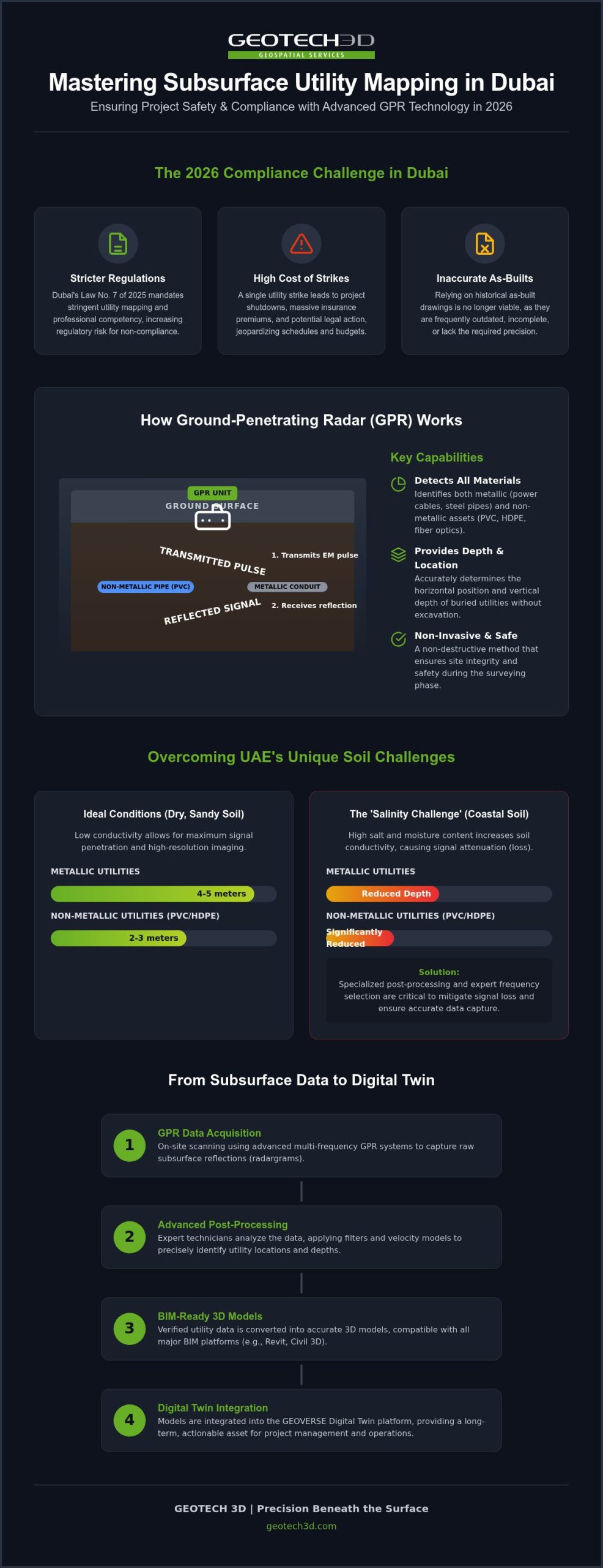
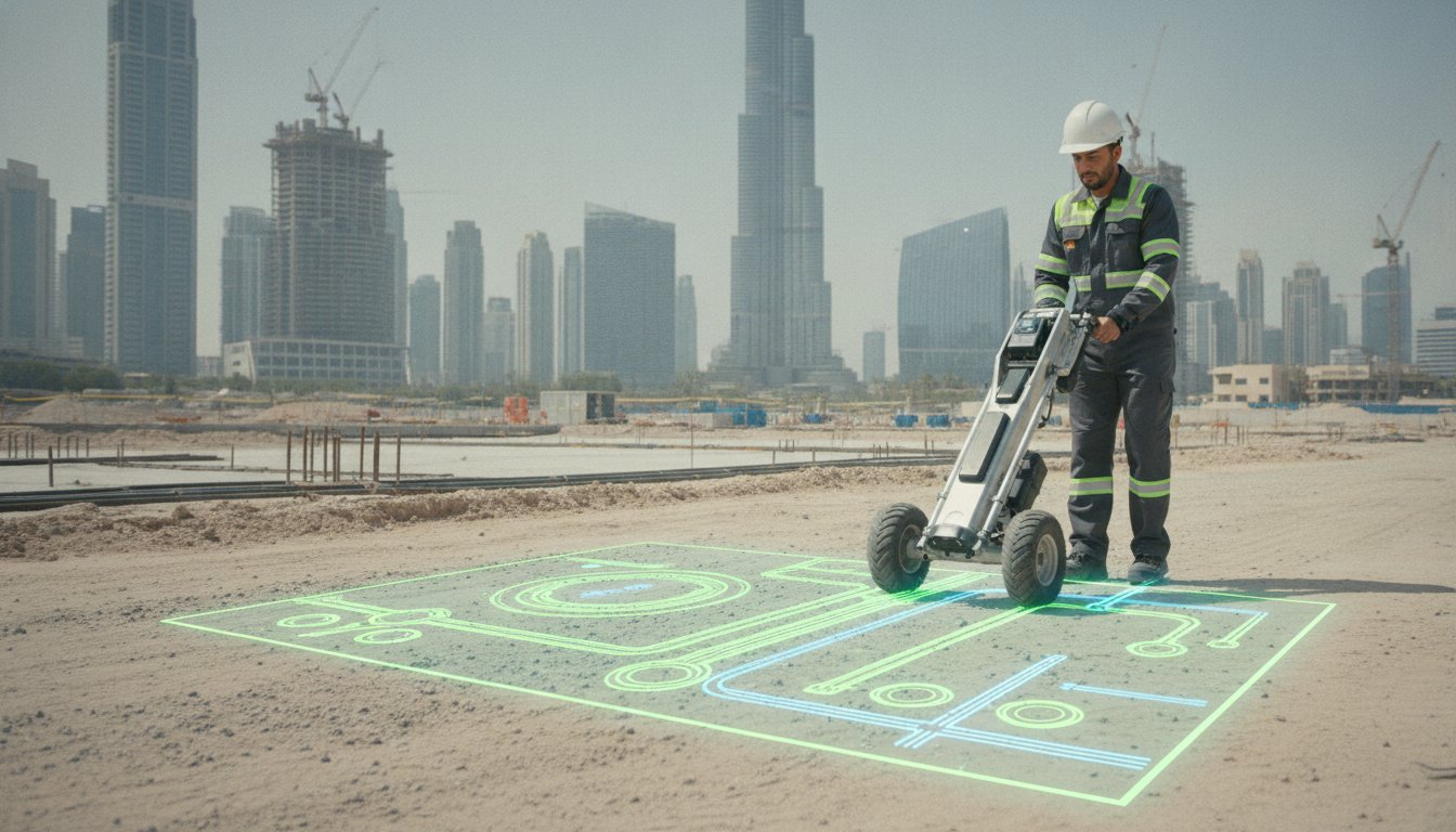
Ground-penetrating radar (GPR) is a non-invasive geophysical method used to image the subsurface. It functions by transmitting high-frequency electromagnetic pulses into the ground. When these waves encounter an object or a boundary between different materials, such as a pipe or a change in soil density, they reflect back to the surface antenna. This technology is highly versatile because it identifies both metallic and non-metallic assets, including PVC, HDPE, and fiber optic conduits. By analyzing these reflections, our teams at GEOTECH 3D can determine the exact location and depth of utilities without breaking ground.
The 2026 Standard for Dubai Construction
In 2026, the standard for utility clearance has evolved. With the implementation of Law No. 7 of 2025, contractors are now under increased scrutiny regarding their technical capabilities and safety protocols. Dubai Municipality and the RTA expect comprehensive utility mapping before any heavy machinery arrives on site. This isn’t just about avoiding a strike; it’s about data integration. The shift from 2D paint markings to 3D subsurface digital records supports the Smart Dubai initiative, allowing project managers to visualize underground risks within a BIM environment. This level of precision ensures that infrastructure projects remain on schedule and fully compliant with the latest municipal mandates. High-stakes GPR utility scanning provides the verified intelligence needed to navigate these requirements with confidence.
Overcoming Technical Challenges: Signal Penetration in UAE Soil
The efficacy of GPR utility scanning is fundamentally tethered to the electromagnetic properties of the ground. While Dubai’s sandy terrain often allows for high-resolution imaging, the presence of moisture and high salt concentrations in coastal areas like Dubai Marina or Palm Jumeirah creates a significant technical hurdle. High soil conductivity in these regions leads to signal attenuation, where the electromagnetic energy is absorbed by the earth rather than reflecting back to the receiver. This can drastically reduce the effective depth of a survey if not managed by an experienced technical partner.
In typical dry sandy conditions across the UAE, GPR systems can generally detect metallic utilities at depths of 4-5 meters, while non-metallic assets like PVC or HDPE pipes are identifiable down to 2-3 meters. However, these figures aren’t static. Achieving these depths requires precise frequency selection and a deep understanding of local geophysics to ensure that the data captured is both accurate and actionable for the construction team.
Soil Conductivity and Signal Loss
The ‘Salinity Challenge’ is a primary concern for infrastructure projects near the coast. Saltwater intrusion increases soil conductivity, which acts as a shield against radar pulses. To overcome this, we utilize specialized post-processing techniques such as hyperbola fitting to determine the exact velocity of the radar wave through the local soil. This calibration is essential for converting the signal’s travel time into an accurate depth measurement. Selecting the right antenna is equally critical; a 200MHz antenna provides the deep penetration needed for large drainage lines in desert terrain, whereas a high-frequency 2GHz antenna is reserved for shallow, high-resolution tasks like rebar mapping in concrete slabs.
Advanced Data Acquisition Strategies
Successful data acquisition on a complex Dubai site depends on the methodology used to navigate these environmental factors. We prioritize grid scanning over single-line paths to create a comprehensive 3D volume of the subsurface. This approach allows us to identify skewed or non-linear utilities that a simple cross-section might miss. Additionally, multi-frequency arrays enable the simultaneous capture of deep and shallow assets, increasing efficiency and reducing site time.
Environmental management also plays a role in data integrity. The extreme UAE heat can affect sensitive electronic sensors, requiring strict operational protocols to prevent hardware thermal drift. Ensuring your project utilizes a team that understands utility mapping in the UAE is the best way to mitigate these technical risks and maintain your project schedule. By filtering out the ‘noise’ inherent in sandy and saline environments, we provide the clarity needed for safe excavation and precise BIM integration.
GPR vs. Traditional Utility Locating: Choosing the Right Methodology
Selecting the correct detection methodology is a strategic decision that directly impacts the safety and efficiency of your project. While GPR utility scanning is a cornerstone of modern subsurface mapping, it is rarely a standalone solution. Achieving 100% site confidence in Dubai’s complex infrastructure requires a tiered approach that recognizes the strengths and limitations of different geophysical technologies. By integrating various methods, we ensure that both metallic and non-metallic assets are identified with the precision required for 2026 construction standards.
A hybrid strategy is mandatory because no single sensor can “see” every underground feature. For instance, while radar pulses reflect off most materials, electromagnetic locating (EML) provides superior results for tracing live power cables and metallic pipes by detecting the electromagnetic fields they emit. At GEOTECH 3D, we combine these technologies to create a comprehensive subsurface profile that leaves no room for ambiguity.
The SUE Quality Framework
In the UAE, we categorize our survey results using the Subsurface Utility Engineering (SUE) quality levels, often referencing the PAS 128:2022 standard. This framework allows project managers to understand the reliability of the data they are using:
- QL-D (Desktop Study): Based on existing records and as-built drawings. These are the least reliable and should never be used for excavation.
- QL-C (Site Reconnaissance): Surveying surface-visible features like manholes and valve boxes to correlate with records.
- QL-B (Geophysical Locating): This is where GPR utility scanning and EML are deployed to provide horizontal and estimated vertical positions.
- QL-A (Precise Verification): The highest level of accuracy, achieved through non-destructive vacuum excavation to physically expose and measure the asset.
EML vs. GPR: A Tactical Comparison
EML is the tool of choice for metallic utilities, especially live power lines and telecommunications cables that carry a signal. It is fast and provides high accuracy for specific lines. However, EML cannot detect non-conductive materials. This is why GPR is indispensable; it’s the only reliable method for locating PVC conduits, HDPE water mains, concrete drainage pipes, and fiber optic cables that lack a tracer wire.
Despite the power of high-end GPR teams, limitations such as high soil salinity can occasionally hinder signal penetration. In these specific scenarios, we recommend supplementing geophysical data with vacuum excavation. This ensures that even in the most challenging UAE soil conditions, your project remains compliant with Dubai Municipality safety mandates and maintains a zero-strike record.
Connecting Subsurface Data to Scan-to-BIM & Digital Twins
The construction industry in Dubai has moved beyond the era of ephemeral field markings and “paint on the ground.” In 2026, GPR utility scanning serves as the primary data source for the subsurface digital twin, a requirement for any high-stakes infrastructure project. This transition allows engineers to visualize underground networks with the same fidelity as the skyscrapers above them. By digitizing these assets, project teams can identify potential clashes during the design phase rather than discovering them during expensive excavation phases. It’s a shift from reactive site management to proactive digital coordination.
A unified digital record provides immense value for facility management and future renovations. Instead of relying on fragmented records, stakeholders can access a single source of truth that documents every pipe, cable, and conduit. This level of transparency is essential for maintaining the world-class reliability of Dubai’s utility grids, ensuring that future maintenance doesn’t disrupt the city’s operational rhythm.
Creating the Subsurface Digital Twin
Traditional utility surveys often result in 2D CAD files that lack critical vertical context. We enhance this process by integrating subsurface data with BIM modeling from laser scans. This creates a holistic 3D environment where foundations, piling, and utilities are mapped in relation to one another. Utilizing 3D utility data reduces design changes by up to 40% by revealing conflicts before they reach the field. This integration allows for precise clash detection, ensuring that new infrastructure doesn’t interfere with existing District Cooling lines or DEWA high-voltage networks.
The GEOVERSE Advantage
GEOTECH 3D leverages the proprietary GEOVERSE Platform to provide stakeholders with city-scale spatial analysis. It is a cloud-based solution that allows consultants, contractors, and asset owners to view underground assets in real-time. This ensures data longevity, transforming a one-time survey into a living record for asset lifecycle management. Whether you’re managing a site in Al Qusais or a massive development in Dubai South, having cloud-based access to subsurface data streamlines decision-making and enhances safety across the board.
Ensuring your data is BIM-ready is the most effective way to protect your investment. By capturing raw GPR utility scanning data and converting it into intelligent 3D models, we provide the technical foundation for the next generation of Dubai’s smart city infrastructure. This methodical approach to data acquisition and modeling supports the city’s long-term vision of a fully integrated digital environment.
Integrate your subsurface data into a BIM-ready Digital Twin today
GEOTECH 3D: Your Partner for Precise Utility Mapping in the UAE
In the high-stakes environment of Dubai’s 2026 construction sector, selecting a technical partner is as critical as the technology itself. GEOTECH 3D provides a bridge between complex raw data and actionable project intelligence. Our commitment to precision ensures that every GPR utility scanning mission we undertake is grounded in safety and schedule compliance. We don’t just deliver a report; we provide an end-to-end subsurface engineering solution that moves seamlessly from field acquisition to BIM-compatible deliverables. This holistic approach is why leading contractors across the UAE trust us to safeguard their most ambitious infrastructure investments.
We understand that a project’s success depends on the reliability of its foundation. By choosing a partner that prioritizes technical integrity and long-term commitment, you’re not just hiring a service provider; you’re forming a collaborative alliance. Our goal is to instill a sense of security in the face of complex technical requirements, allowing your team to focus on delivery while we manage the subsurface risks.
Professional Expertise and Local Compliance
Our team brings decades of collective experience to the table, having navigated the intricate and often undocumented utility networks of the Middle East. We don’t guess; we verify. Every survey we conduct adheres to international Subsurface Utility Engineering (SUE) standards, specifically the PAS 128:2022 framework, while remaining fully aligned with the latest Dubai Municipality and RTA guidelines. This dual commitment to global best practices and local regulatory requirements ensures your project remains compliant and strike-free. For a detailed site assessment or to discuss your project requirements, you can visit our office at Ilyaa Tower 2 – Office 101, Damascus St., Al Qusais Industrial 3, Dubai, or reach us directly at +971 4 295 1589.
Comprehensive Geospatial Synergy
Precision mapping requires a multi-layered perspective. We achieve this by combining GPR with Drone Surveying and Aerial Mapping to capture both surface and subsurface realities in a single, unified coordinate system. This geospatial synergy allows us to provide GIS-ready data that is essential for cadastral mapping, land-tax documentation, and large-scale urban planning. By integrating these diverse datasets, we empower developers and asset owners with a comprehensive understanding of their land, facilitating smoother approvals and more efficient site development.
As you prepare for your next project, remember that the quality of your subsurface data dictates the safety of your site. Our role is to act as your faithful guide, using our expertise to eliminate uncertainty and empower your team with the most accurate documentation available in the region. We invite you to leverage our advanced sensing technologies to ensure your 2026 project workflows are optimized for success.
Securing the Future of Dubai’s Underground Infrastructure
Precision in subsurface mapping is no longer a luxury for Dubai’s construction sector; it’s a fundamental requirement for operational continuity. By adopting advanced GPR utility scanning, you ensure your project remains compliant with the evolving regulatory landscape of 2026. This includes meeting the strict mandates of Dubai Municipality and the RTA classification systems. A proactive approach transforms underground uncertainty into a strategic asset, protecting your schedule from the financial and legal fallout of utility strikes.
Beyond immediate safety, the transition to 3D subsurface models and GEOVERSE Digital Twin integration provides a long-term roadmap for sustainable asset management. As a specialist in accurate 3D models for the infrastructure and Oil & Gas sectors, we’re dedicated to helping you master these technical complexities. You’re getting more than just a survey; you’re gaining a partner in project precision. Our Dubai team is ready to provide the expertise you need to secure your site from our office at Ilyaa Tower 2, Damascus Street. Reach out to us at +971 4 295 1589 to begin your site assessment.
Let’s build a safer, more transparent future for Dubai’s urban landscape together.
Frequently Asked Questions
What is the maximum depth GPR can reach in Dubai’s sandy soil?
In typical dry sandy soil conditions across Dubai, GPR can detect metallic utilities at depths of 4 to 5 meters and non-metallic assets at 2 to 3 meters. These depths are achievable through precise frequency selection and expert calibration to account for the specific geophysics of the UAE terrain. However, the exact range depends on soil conductivity and the diameter of the asset. Our teams use high-resolution antennas to ensure the most accurate subsurface profile possible.
Can GPR utility scanning detect non-metallic pipes like PVC or HDPE?
Yes, GPR utility scanning is specifically designed to detect non-metallic assets such as PVC, HDPE, clay, and fiber optic conduits. Unlike electromagnetic locating, which requires a conductive path, GPR relies on dielectric contrasts between the pipe material and the surrounding soil. This makes it an essential tool for mapping modern infrastructure in the UAE, where non-conductive materials are increasingly common in water distribution and telecommunications networks.
Is GPR scanning safe to perform in high-traffic or residential areas?
GPR is completely safe for use in high-traffic and residential areas because it’s a non-invasive, non-destructive testing method. The electromagnetic pulses emitted by the equipment are low-power and don’t interfere with communications or medical devices. Since the process doesn’t require excavation or surface disruption, it allows for seamless data collection along busy Dubai roads or within occupied communities without causing noise pollution or structural risk to adjacent properties.
How long does a typical GPR utility survey take for a 1-hectare site?
A typical GPR survey for a 1-hectare site in Dubai generally takes between one and two days for field data acquisition. This duration varies based on the density of existing utilities and the required grid spacing for the survey. Following the site work, our technical team performs advanced post-processing to filter noise and verify asset depths. We prioritize strict project schedules to ensure that your 2026 construction timelines remain on track without compromising accuracy.
What is the difference between GPR and Subsurface Utility Engineering (SUE)?
GPR is a specific geophysical technology, while Subsurface Utility Engineering (SUE) is a comprehensive engineering process used to manage risks associated with underground assets. SUE incorporates GPR as part of its geophysical locating phase, known as Quality Level B. While GPR provides the raw data, the SUE framework at GEOTECH 3D integrates that data with professional surveying, record research, and non-destructive exposure to create a highly reliable 3D map of the subsurface environment.
How does GEOTECH 3D deliver utility data for BIM integration?
We deliver utility data for BIM integration by converting raw point cloud and GPR findings into intelligent 3D models compatible with standard CAD packages. Our Scan-to-BIM workflow ensures that every underground pipe and cable is represented with accurate horizontal and vertical positioning. Stakeholders can access this information through our GEOVERSE platform, which supports city-scale modeling and allows for real-time clash detection during the design and construction phases of your project.
Does GPR work in areas with high water tables or coastal salinity?
High water tables and coastal salinity in areas like Dubai Marina present a significant challenge by causing signal attenuation. In these environments, the electromagnetic energy is absorbed by the soil, which can limit the effective depth of the scan. To mitigate this, GEOTECH 3D uses advanced post-processing filters and selects specific antenna frequencies to penetrate the ground more effectively. We often supplement radar data with other geophysical methods to ensure 100% site confidence.
What are the requirements for GPR survey compliance in Dubai?
Compliance for GPR surveys in Dubai requires adherence to the standards set by Dubai Municipality and the RTA. This includes following the PAS 128 framework for utility mapping and ensuring that technical staff hold the necessary professional competency certificates. Under the new Law No. 7 of 2025, contractors must also be registered in the unified Contractor Register. Our GPR utility scanning services are designed to meet these rigorous data submission formats, ensuring your excavation permits are approved without delay.
In 2026, a single utility strike in Dubai is no longer just a costly operational setback; it is a significant regulatory risk that can jeopardize your firm’s standing under the new Law No. 7 of 2025. With the Dubai Municipality now enforcing strict classification tiers and professional competency certifications, the margin for error in subsurface detection has effectively vanished. You’ve likely experienced the frustration of relying on inaccurate as-built drawings or struggling with signal attenuation in the UAE’s unique soil conditions. It is a challenge that demands more than just basic detection; it requires a sophisticated, data-driven approach to GPR utility scanning.
We understand that your primary objectives are to maintain project schedules, ensure site safety, and deliver high-fidelity 3D maps that integrate seamlessly into your BIM workflows. This article provides the technical expertise needed to master Ground Penetrating Radar nuances within the local landscape. You’ll learn how to eliminate utility strikes, achieve compliance with RTA and Dubai Municipality standards, and transform raw subsurface data into actionable assets for your digital twin. We’ll explore the latest methodologies for navigating Dubai’s complex infrastructure, ensuring your 2026 projects are built on a foundation of precision and verified intelligence.
Key Takeaways
- Understand how advanced subsurface mapping ensures compliance with the latest Dubai Municipality regulations and prevents costly project delays.
- Master the technical nuances of GPR utility scanning to overcome signal attenuation caused by the high soil salinity unique to the UAE’s coastal environments.
- Learn to distinguish between GPR and electromagnetic locating (EML) while applying SUE Quality Levels to achieve a higher standard of subsurface reliability.
- Discover how raw subsurface data is transformed into BIM-ready 3D models and integrated into the GEOVERSE Digital Twin platform for long-term asset management.
- Identify the strategic advantages of transitioning from traditional as-builts to accurate 3D documentation to eliminate utility strikes in 2026 infrastructure projects.
Navigating the Subsurface: The Critical Role of GPR Utility Scanning in Dubai
Dubai’s urban landscape is a marvel of engineering above ground, but the complexity beneath the surface is equally significant. As the city continues its rapid expansion in 2026, the density of underground assets has reached a point where traditional excavation methods carry unacceptable risks. Relying on historical as-built drawings is no longer a viable strategy; these records are frequently outdated or lack the precision required for modern piling and shoring operations. Professional GPR utility scanning has transitioned from a specialized service to a mandatory prerequisite for any project aiming for zero-incident safety records and regulatory compliance.
The subsurface environment in the UAE is unique. It houses a sophisticated network ranging from high-voltage DEWA power cables and telecommunications fiber optics to critical District Cooling pipes and pressurized water mains. Striking any of these leads to immediate project shutdowns, massive insurance premiums, and potential legal action under Dubai’s stricter 2026 construction laws. The cost of ‘blind’ excavation is simply too high, both in terms of financial penalties and site safety.
What is GPR Utility Scanning?
Ground-penetrating radar (GPR) is a non-invasive geophysical method used to image the subsurface. It functions by transmitting high-frequency electromagnetic pulses into the ground. When these waves encounter an object or a boundary between different materials, such as a pipe or a change in soil density, they reflect back to the surface antenna. This technology is highly versatile because it identifies both metallic and non-metallic assets, including PVC, HDPE, and fiber optic conduits. By analyzing these reflections, our teams at GEOTECH 3D can determine the exact location and depth of utilities without breaking ground.
The 2026 Standard for Dubai Construction
In 2026, the standard for utility clearance has evolved. With the implementation of Law No. 7 of 2025, contractors are now under increased scrutiny regarding their technical capabilities and safety protocols. Dubai Municipality and the RTA expect comprehensive utility mapping before any heavy machinery arrives on site. This isn’t just about avoiding a strike; it’s about data integration. The shift from 2D paint markings to 3D subsurface digital records supports the Smart Dubai initiative, allowing project managers to visualize underground risks within a BIM environment. This level of precision ensures that infrastructure projects remain on schedule and fully compliant with the latest municipal mandates. High-stakes GPR utility scanning provides the verified intelligence needed to navigate these requirements with confidence.
Overcoming Technical Challenges: Signal Penetration in UAE Soil
The efficacy of GPR utility scanning is fundamentally tethered to the electromagnetic properties of the ground. While Dubai’s sandy terrain often allows for high-resolution imaging, the presence of moisture and high salt concentrations in coastal areas like Dubai Marina or Palm Jumeirah creates a significant technical hurdle. High soil conductivity in these regions leads to signal attenuation, where the electromagnetic energy is absorbed by the earth rather than reflecting back to the receiver. This can drastically reduce the effective depth of a survey if not managed by an experienced technical partner.
In typical dry sandy conditions across the UAE, GPR systems can generally detect metallic utilities at depths of 4-5 meters, while non-metallic assets like PVC or HDPE pipes are identifiable down to 2-3 meters. However, these figures aren’t static. Achieving these depths requires precise frequency selection and a deep understanding of local geophysics to ensure that the data captured is both accurate and actionable for the construction team.
Soil Conductivity and Signal Loss
The ‘Salinity Challenge’ is a primary concern for infrastructure projects near the coast. Saltwater intrusion increases soil conductivity, which acts as a shield against radar pulses. To overcome this, we utilize specialized post-processing techniques such as hyperbola fitting to determine the exact velocity of the radar wave through the local soil. This calibration is essential for converting the signal’s travel time into an accurate depth measurement. Selecting the right antenna is equally critical; a 200MHz antenna provides the deep penetration needed for large drainage lines in desert terrain, whereas a high-frequency 2GHz antenna is reserved for shallow, high-resolution tasks like rebar mapping in concrete slabs.
Advanced Data Acquisition Strategies
Successful data acquisition on a complex Dubai site depends on the methodology used to navigate these environmental factors. We prioritize grid scanning over single-line paths to create a comprehensive 3D volume of the subsurface. This approach allows us to identify skewed or non-linear utilities that a simple cross-section might miss. Additionally, multi-frequency arrays enable the simultaneous capture of deep and shallow assets, increasing efficiency and reducing site time.
Environmental management also plays a role in data integrity. The extreme UAE heat can affect sensitive electronic sensors, requiring strict operational protocols to prevent hardware thermal drift. Ensuring your project utilizes a team that understands utility mapping in the UAE is the best way to mitigate these technical risks and maintain your project schedule. By filtering out the ‘noise’ inherent in sandy and saline environments, we provide the clarity needed for safe excavation and precise BIM integration.
GPR vs. Traditional Utility Locating: Choosing the Right Methodology
Selecting the correct detection methodology is a strategic decision that directly impacts the safety and efficiency of your project. While GPR utility scanning is a cornerstone of modern subsurface mapping, it is rarely a standalone solution. Achieving 100% site confidence in Dubai’s complex infrastructure requires a tiered approach that recognizes the strengths and limitations of different geophysical technologies. By integrating various methods, we ensure that both metallic and non-metallic assets are identified with the precision required for 2026 construction standards.
A hybrid strategy is mandatory because no single sensor can “see” every underground feature. For instance, while radar pulses reflect off most materials, electromagnetic locating (EML) provides superior results for tracing live power cables and metallic pipes by detecting the electromagnetic fields they emit. At GEOTECH 3D, we combine these technologies to create a comprehensive subsurface profile that leaves no room for ambiguity.
The SUE Quality Framework
In the UAE, we categorize our survey results using the Subsurface Utility Engineering (SUE) quality levels, often referencing the PAS 128:2022 standard. This framework allows project managers to understand the reliability of the data they are using:
- QL-D (Desktop Study): Based on existing records and as-built drawings. These are the least reliable and should never be used for excavation.
- QL-C (Site Reconnaissance): Surveying surface-visible features like manholes and valve boxes to correlate with records.
- QL-B (Geophysical Locating): This is where GPR utility scanning and EML are deployed to provide horizontal and estimated vertical positions.
- QL-A (Precise Verification): The highest level of accuracy, achieved through non-destructive vacuum excavation to physically expose and measure the asset.
EML vs. GPR: A Tactical Comparison
EML is the tool of choice for metallic utilities, especially live power lines and telecommunications cables that carry a signal. It is fast and provides high accuracy for specific lines. However, EML cannot detect non-conductive materials. This is why GPR is indispensable; it’s the only reliable method for locating PVC conduits, HDPE water mains, concrete drainage pipes, and fiber optic cables that lack a tracer wire.
Despite the power of high-end GPR teams, limitations such as high soil salinity can occasionally hinder signal penetration. In these specific scenarios, we recommend supplementing geophysical data with vacuum excavation. This ensures that even in the most challenging UAE soil conditions, your project remains compliant with Dubai Municipality safety mandates and maintains a zero-strike record.
Connecting Subsurface Data to Scan-to-BIM & Digital Twins
The construction industry in Dubai has moved beyond the era of ephemeral field markings and “paint on the ground.” In 2026, GPR utility scanning serves as the primary data source for the subsurface digital twin, a requirement for any high-stakes infrastructure project. This transition allows engineers to visualize underground networks with the same fidelity as the skyscrapers above them. By digitizing these assets, project teams can identify potential clashes during the design phase rather than discovering them during expensive excavation phases. It’s a shift from reactive site management to proactive digital coordination.
A unified digital record provides immense value for facility management and future renovations. Instead of relying on fragmented records, stakeholders can access a single source of truth that documents every pipe, cable, and conduit. This level of transparency is essential for maintaining the world-class reliability of Dubai’s utility grids, ensuring that future maintenance doesn’t disrupt the city’s operational rhythm.
Creating the Subsurface Digital Twin
Traditional utility surveys often result in 2D CAD files that lack critical vertical context. We enhance this process by integrating subsurface data with BIM modeling from laser scans. This creates a holistic 3D environment where foundations, piling, and utilities are mapped in relation to one another. Utilizing 3D utility data reduces design changes by up to 40% by revealing conflicts before they reach the field. This integration allows for precise clash detection, ensuring that new infrastructure doesn’t interfere with existing District Cooling lines or DEWA high-voltage networks.
The GEOVERSE Advantage
GEOTECH 3D leverages the proprietary GEOVERSE Platform to provide stakeholders with city-scale spatial analysis. It is a cloud-based solution that allows consultants, contractors, and asset owners to view underground assets in real-time. This ensures data longevity, transforming a one-time survey into a living record for asset lifecycle management. Whether you’re managing a site in Al Qusais or a massive development in Dubai South, having cloud-based access to subsurface data streamlines decision-making and enhances safety across the board.
Ensuring your data is BIM-ready is the most effective way to protect your investment. By capturing raw GPR utility scanning data and converting it into intelligent 3D models, we provide the technical foundation for the next generation of Dubai’s smart city infrastructure. This methodical approach to data acquisition and modeling supports the city’s long-term vision of a fully integrated digital environment.
Integrate your subsurface data into a BIM-ready Digital Twin today
GEOTECH 3D: Your Partner for Precise Utility Mapping in the UAE
In the high-stakes environment of Dubai’s 2026 construction sector, selecting a technical partner is as critical as the technology itself. GEOTECH 3D provides a bridge between complex raw data and actionable project intelligence. Our commitment to precision ensures that every GPR utility scanning mission we undertake is grounded in safety and schedule compliance. We don’t just deliver a report; we provide an end-to-end subsurface engineering solution that moves seamlessly from field acquisition to BIM-compatible deliverables. This holistic approach is why leading contractors across the UAE trust us to safeguard their most ambitious infrastructure investments.
We understand that a project’s success depends on the reliability of its foundation. By choosing a partner that prioritizes technical integrity and long-term commitment, you’re not just hiring a service provider; you’re forming a collaborative alliance. Our goal is to instill a sense of security in the face of complex technical requirements, allowing your team to focus on delivery while we manage the subsurface risks.
Professional Expertise and Local Compliance
Our team brings decades of collective experience to the table, having navigated the intricate and often undocumented utility networks of the Middle East. We don’t guess; we verify. Every survey we conduct adheres to international Subsurface Utility Engineering (SUE) standards, specifically the PAS 128:2022 framework, while remaining fully aligned with the latest Dubai Municipality and RTA guidelines. This dual commitment to global best practices and local regulatory requirements ensures your project remains compliant and strike-free. For a detailed site assessment or to discuss your project requirements, you can visit our office at Ilyaa Tower 2 – Office 101, Damascus St., Al Qusais Industrial 3, Dubai, or reach us directly at +971 4 295 1589.
Comprehensive Geospatial Synergy
Precision mapping requires a multi-layered perspective. We achieve this by combining GPR with Drone Surveying and Aerial Mapping to capture both surface and subsurface realities in a single, unified coordinate system. This geospatial synergy allows us to provide GIS-ready data that is essential for cadastral mapping, land-tax documentation, and large-scale urban planning. By integrating these diverse datasets, we empower developers and asset owners with a comprehensive understanding of their land, facilitating smoother approvals and more efficient site development.
As you prepare for your next project, remember that the quality of your subsurface data dictates the safety of your site. Our role is to act as your faithful guide, using our expertise to eliminate uncertainty and empower your team with the most accurate documentation available in the region. We invite you to leverage our advanced sensing technologies to ensure your 2026 project workflows are optimized for success.
Securing the Future of Dubai’s Underground Infrastructure
Precision in subsurface mapping is no longer a luxury for Dubai’s construction sector; it’s a fundamental requirement for operational continuity. By adopting advanced GPR utility scanning, you ensure your project remains compliant with the evolving regulatory landscape of 2026. This includes meeting the strict mandates of Dubai Municipality and the RTA classification systems. A proactive approach transforms underground uncertainty into a strategic asset, protecting your schedule from the financial and legal fallout of utility strikes.
Beyond immediate safety, the transition to 3D subsurface models and GEOVERSE Digital Twin integration provides a long-term roadmap for sustainable asset management. As a specialist in accurate 3D models for the infrastructure and Oil & Gas sectors, we’re dedicated to helping you master these technical complexities. You’re getting more than just a survey; you’re gaining a partner in project precision. Our Dubai team is ready to provide the expertise you need to secure your site from our office at Ilyaa Tower 2, Damascus Street. Reach out to us at +971 4 295 1589 to begin your site assessment.
Let’s build a safer, more transparent future for Dubai’s urban landscape together.
Frequently Asked Questions
What is the maximum depth GPR can reach in Dubai’s sandy soil?
In typical dry sandy soil conditions across Dubai, GPR can detect metallic utilities at depths of 4 to 5 meters and non-metallic assets at 2 to 3 meters. These depths are achievable through precise frequency selection and expert calibration to account for the specific geophysics of the UAE terrain. However, the exact range depends on soil conductivity and the diameter of the asset. Our teams use high-resolution antennas to ensure the most accurate subsurface profile possible.
Can GPR utility scanning detect non-metallic pipes like PVC or HDPE?
Yes, GPR utility scanning is specifically designed to detect non-metallic assets such as PVC, HDPE, clay, and fiber optic conduits. Unlike electromagnetic locating, which requires a conductive path, GPR relies on dielectric contrasts between the pipe material and the surrounding soil. This makes it an essential tool for mapping modern infrastructure in the UAE, where non-conductive materials are increasingly common in water distribution and telecommunications networks.
Is GPR scanning safe to perform in high-traffic or residential areas?
GPR is completely safe for use in high-traffic and residential areas because it’s a non-invasive, non-destructive testing method. The electromagnetic pulses emitted by the equipment are low-power and don’t interfere with communications or medical devices. Since the process doesn’t require excavation or surface disruption, it allows for seamless data collection along busy Dubai roads or within occupied communities without causing noise pollution or structural risk to adjacent properties.
How long does a typical GPR utility survey take for a 1-hectare site?
A typical GPR survey for a 1-hectare site in Dubai generally takes between one and two days for field data acquisition. This duration varies based on the density of existing utilities and the required grid spacing for the survey. Following the site work, our technical team performs advanced post-processing to filter noise and verify asset depths. We prioritize strict project schedules to ensure that your 2026 construction timelines remain on track without compromising accuracy.
What is the difference between GPR and Subsurface Utility Engineering (SUE)?
GPR is a specific geophysical technology, while Subsurface Utility Engineering (SUE) is a comprehensive engineering process used to manage risks associated with underground assets. SUE incorporates GPR as part of its geophysical locating phase, known as Quality Level B. While GPR provides the raw data, the SUE framework at GEOTECH 3D integrates that data with professional surveying, record research, and non-destructive exposure to create a highly reliable 3D map of the subsurface environment.
How does GEOTECH 3D deliver utility data for BIM integration?
We deliver utility data for BIM integration by converting raw point cloud and GPR findings into intelligent 3D models compatible with standard CAD packages. Our Scan-to-BIM workflow ensures that every underground pipe and cable is represented with accurate horizontal and vertical positioning. Stakeholders can access this information through our GEOVERSE platform, which supports city-scale modeling and allows for real-time clash detection during the design and construction phases of your project.
Does GPR work in areas with high water tables or coastal salinity?
High water tables and coastal salinity in areas like Dubai Marina present a significant challenge by causing signal attenuation. In these environments, the electromagnetic energy is absorbed by the soil, which can limit the effective depth of the scan. To mitigate this, GEOTECH 3D uses advanced post-processing filters and selects specific antenna frequencies to penetrate the ground more effectively. We often supplement radar data with other geophysical methods to ensure 100% site confidence.
What are the requirements for GPR survey compliance in Dubai?
Compliance for GPR surveys in Dubai requires adherence to the standards set by Dubai Municipality and the RTA. This includes following the PAS 128 framework for utility mapping and ensuring that technical staff hold the necessary professional competency certificates. Under the new Law No. 7 of 2025, contractors must also be registered in the unified Contractor Register. Our GPR utility scanning services are designed to meet these rigorous data submission formats, ensuring your excavation permits are approved without delay.
Search Now
Error: Contact form not found.