

Our Services
High-Precision Land Surveying in the GCC: A Practical Guide
A survey can be technically precise and still fail to support a project if its scope, outputs or capture method do not match the decisions ahead. For high precision land surveying GCC projects, the key question is not simply how accurate the data is. It is whether the survey captures the right information for design, planning or construction in Dubai and the UAE.
It can be difficult to distinguish Land Survey from Topographic Mapping or Aerial Survey, especially when several types of information are needed for one project. A fit-for-purpose scope connects site conditions, required data and intended use, helping teams identify gaps before they affect design coordination or construction planning.
This guide explains how to prepare a practical survey brief, compare common approaches and identify the outputs and access requirements to consider before commissioning work. It also explains how GEOTECH 3D’s Land Survey, Topographic Mapping, Aerial Survey and Digital Photogrammetry Services relate to different project needs in Dubai and the UAE.
Key Takeaways
- Match survey scope to the decisions your project needs to make, rather than relying on a general accuracy claim.
- Specify accuracy, detail and coverage separately when describing information needed for planning, design coordination or construction.
- Compare Land Survey, Topographic Mapping, Aerial Survey and Digital Photogrammetry Services against site conditions, access and required outputs.
- Build a practical brief by setting the objective first, then defining the site, scope, access, outputs and coordination needs.
- GEOTECH 3D provides these surveying services for project requirements in Dubai and across the UAE.
Why High-Precision Land Surveying Matters for Dubai and UAE Projects
Decisions made before work begins can shape a project long after the survey team leaves the site. Developers use site information to assess development options. Consultants and engineers rely on it to coordinate designs with existing conditions. Contractors use it to plan construction activities, while asset owners need a usable record of the land and features they manage. In Dubai and across the UAE, shared, measured site information helps teams plan from the same understanding of existing conditions.
High precision land surveying GCC projects should be scoped around the decisions the data must support. Land Survey and Topographic Mapping can provide different types of site information, from land measurements to terrain and visible features. The right scope depends on the project’s purpose and required outputs, not on a claim that one survey suits every use.
Which project decisions rely on land survey data?
Survey information can inform site development, infrastructure planning and construction coordination. Terrain data, for instance, helps a design team understand changes in ground level. Measured site information can help the team assess a proposed layout against the land being developed. In both cases, coverage and deliverables should reflect the decision at hand.
- Developers can use site information to assess development options and support early planning.
- Consultants and engineers can coordinate design with measured site conditions and identify where additional information is needed.
- Contractors can use relevant survey outputs to support construction planning and coordination with design documentation.
- Asset owners can use a site record to inform decisions about the land and existing assets they manage.
Land surveying includes methods for measuring and representing land; the Land Surveying Techniques and History overview provides broader background on the discipline. For a live project, the practical questions are more specific: what needs to be measured, which area must be covered, and how will the resulting information be used?
What does high precision mean in a project context?
Precision describes how consistently measurements can be obtained. Detail concerns how much information is represented, while coverage describes the area captured. These requirements are related, but they are not interchangeable. A detailed survey of only part of a site may not answer a question that depends on wider coverage.
Fit-for-purpose survey data is measured and delivered to support defined project decisions across the required site area. To achieve that, the brief should state the intended use and any documented project requirements, such as accuracy criteria, coordinate system or output format. These requirements vary by project, so assuming a generic standard can lead to a scope that does not match the work.
An unclear brief can leave teams with data that is difficult to apply. For example, the survey may represent terrain but omit features needed for coordination, or its limits may not cover a key design interface. Define the project decision first, then identify the information needed to support it. GEOTECH 3D’s Land Survey and Topographic Mapping can be scoped around those information needs.
What Shapes High-Precision Land Survey Results?
Survey results reflect several connected decisions: the area and features included in the scope, the conditions encountered on site, the capture approach, and the way information is processed and delivered. If any of these elements is unclear, the final dataset may be incomplete or difficult for the project team to use.
Useful survey results depend on coordinated scope, site access, capture planning and deliverables, not on a single instrument setting. For high precision land surveying GCC projects, document the project’s requirements and treat these elements as parts of one specification before fieldwork begins.
Accuracy, detail, and coverage are different requirements
Specify accuracy, detail and coverage separately rather than assuming one guarantees the others. A site may need broad coverage for an overall terrain review, with closer attention to selected design interfaces. More detail in one area will not compensate if another required area falls outside the survey limits. Refer to project documents for accuracy criteria, and avoid adding generic tolerances that are not tied to the project.
How survey scope connects to usable project information
Define the work boundary and identify the terrain and existing features relevant to the project. State whether the team needs information across the full site or focused coverage around particular areas, such as access routes or proposed infrastructure interfaces. This helps separate essential survey requirements from contextual information that may be useful but is not required for the current deliverable.
Topographic Mapping and Land Survey can support different information requirements within that scope. Topographic Mapping represents terrain and relevant site features. Land Survey can be defined around the land information required for a project. Make clear which outputs answer which project questions, particularly when both service types are part of a coordinated package.
Site conditions affect how data can be captured. Obstructions, restricted areas, visibility and safe access can affect which features are observable and whether additional coordination is needed. Share known access constraints and site information early so the survey team can plan coverage and capture methods. If an area cannot be accessed, document the limitation so the project team understands what the deliverables cover.
- Capture planning: Relate the approach to site conditions and required information, not simply to a general preference for a particular technology.
- Quality requirements: Record project-defined accuracy criteria and any verification requirements in the scope.
- Outputs: State required formats and reference systems when they are specified by project documentation.
- Coordination: Identify the design or delivery teams that will use the data and the project interfaces it needs to support.
A clear scope and defined deliverables connect data collection to project workflows. GEOTECH 3D’s GIS & Surveying Services include Land Survey and Topographic Mapping for project-specific site information needs.
Land Survey, Topographic Mapping, or Aerial Survey: Which Approach Fits?
Choose an approach by defining the information needed, then considering the site area, access conditions and intended outputs. For development and infrastructure projects in Dubai and across the UAE, Land Survey, Topographic Mapping, Aerial Survey and Digital Photogrammetry Services can answer different questions. They are not interchangeable, and no method is universally more accurate, faster or less costly than another.
| Approach | Intended use | Coverage and access | Project question |
|---|---|---|---|
| Land Survey | Measured land information scoped to a defined project purpose. | Set the site limits and required areas; access needs depend on the features to be measured. | What land information does the design or project team need? |
| Topographic Mapping | Representing terrain and relevant site features for planning or design coordination. | Define the area and features to map; site visibility and access affect scope. | How does the ground and its visible features relate to the proposed works? |
| Aerial Survey | Collecting aerial data for a project scope that may involve broader site coverage. | Consider site conditions, access and whether aerial capture suits the required area. | Can aerial data support the coverage and outputs the project needs? |
| Digital Photogrammetry Services | Using imagery to produce survey information suited to defined project outputs. | Suitability depends on site conditions, access and the required deliverables. | Can image-based data answer the project’s specified questions? |
When does a project need Land Survey or Topographic Mapping?
A Land Survey scope can support site information requirements for development or infrastructure planning. Topographic Mapping is relevant when teams need terrain and site features represented for layout decisions or design coordination. For example, a project team planning works across a development parcel may need mapped ground conditions. A design team coordinating infrastructure may need terrain information across defined interfaces. In each case, the required coverage and outputs should follow the project purpose, rather than an assumption about legal or cadastral outcomes.
When can Aerial Survey and photogrammetry contribute?
Aerial Survey may suit projects that call for data across a broader area. Digital Photogrammetry Services can contribute image-derived information where the approach fits the site and required deliverables. Neither removes the need for a clear scope. Access, site conditions, coverage and the information the team must use all influence whether aerial capture is appropriate for a particular Dubai or UAE project.
Surface survey and underground utility mapping answer different questions. Land Survey and Topographic Mapping address land, terrain and relevant surface features; they should not be treated as a record of buried services. If design or construction planning depends on underground asset locations, define a separate utilities mapping and GPR scope. This distinction helps prevent surface data from being mistaken for subsurface information.
For high precision land surveying GCC projects, compare approaches against the required site information and deliverables, not the method name alone. GEOTECH 3D’s GIS & Surveying Services include Land Survey, Topographic Mapping, Aerial Survey and Digital Photogrammetry Services, which can be aligned with a clearly defined project scope.
How to Prepare a Land Survey Brief for a Dubai or UAE Project
A clear brief starts with the decision the survey must support, not a preferred instrument or an assumed accuracy figure. This sequence helps developers, consultants, contractors and asset teams describe the work in practical terms. Share available site information and project documentation so the scope reflects site conditions and the intended use of the data.
Define the site, objective, and survey coverage
Set out the project purpose and the areas to be surveyed. Separate information needed for the current decision from optional context or possible future needs. This keeps the immediate scope focused while making clear which information belongs to a later project stage.
- Objective: State the decision the survey will support, such as site development planning, infrastructure design coordination or construction preparation. Name the intended users of the information.
- Site: Provide the location, available boundary information and plans or records that describe the site. Identify areas that are included, excluded or especially important to the project.
- Scope: Specify the information needed. This may relate to terrain, existing surface features, cadastral mapping or another defined requirement. Separate essential survey data from background material that is useful but not required.
- Access: Describe entry arrangements, restricted areas, active operations and site conditions that could affect fieldwork. Include relevant safety requirements and coordination contacts so access can be planned responsibly.
- Outputs: List required deliverables and formats when stated in project specifications. Include documented coordinate system or tolerance requirements rather than relying on assumptions or informal preferences.
- Coordination: Identify the design, construction and asset teams that will use the information, along with project interfaces or timing considerations that affect survey work. This helps align the scope with how the data will be reviewed and applied.
Set access, safety, coordination, and output requirements
Be specific about access. For example, note if parts of a development site are occupied, under active construction or accessible only through controlled entry. Describe relevant site safety procedures and operational constraints. These details help shape a workable field plan, but they do not replace the need to define the information the project requires.
For Dubai and UAE projects, tie requested outputs to project documents. If a consultant or design team has specified file formats, reference systems or tolerances, include them in the brief and identify the source document. If no requirement has been defined, avoid inserting an assumed technical value. GEOTECH 3D can align Land Survey or Topographic Mapping with the project’s stated scope and outputs. For information about these services, see GEOTECH 3D’s surveying services.
If the brief includes underground assets, identify them as a separate information need from surface survey coverage. Underground services require a distinct scope, such as utilities mapping and GPR. State this requirement clearly so subsurface information is not assumed to be part of a surface survey.
A well-structured brief makes high precision land surveying GCC work easier to align with project decisions, site access and deliverables. Define the purpose first, then document the site, scope, access, outputs and coordination requirements.
GEOTECH 3D Land Surveying in Dubai and the UAE
A well-defined survey brief gives the project team a practical basis for selecting services and information outputs. GEOTECH 3D provides GIS & Surveying Services in Dubai and across the UAE, including Topographic Mapping, Land Survey, Aerial Survey and Digital Photogrammetry Services. Each can be aligned with the site information a project needs instead of being treated as a one-size-fits-all package.
Surveying services aligned with project requirements
Topographic Mapping supports scopes that require terrain and relevant site features to be represented for planning or design coordination. Land Survey can be scoped around the land information required for a defined project objective. For both, set out the site, coverage, intended use and requested outputs so the work has a clear purpose.
Where a project calls for broader site coverage, Aerial Survey may be relevant. Digital Photogrammetry Services can contribute when image-derived information fits the site conditions and required deliverables. The suitable approach depends on the project scope, access and outputs needed by the team. GEOTECH 3D also provides Cadastral Mapping and Utility Mapping (GPR) for briefs that require those types of information. State these scopes distinctly, especially when a project needs both surface information and underground asset information.
GEOTECH 3D is professionally registered and licensed, with experience across the Middle East. The company emphasizes safety compliance and the ability to work under tight schedules. For high precision land surveying GCC projects, a considered process starts by defining the information need, then aligning the survey scope and capture approach with the project brief.
Move from a defined brief to a project discussion
Before a project discussion, gather the information that helps translate a requirement into a workable scope. This includes the site location and available boundary information, the decisions the survey must support, the areas and features to be covered, access restrictions and relevant safety requirements. Include project specifications for output formats, coordinate systems or tolerances where these have been defined. Current drawings and other available site information can also help clarify the scope.
Clear inputs help align survey information with design, construction and asset-team needs. They also distinguish essential deliverables from optional context, making the discussion more focused. GEOTECH 3D approaches survey requirements with attention to accurate data acquisition, safety and project coordination, tailoring the scope to the stated objectives and site conditions.
Bring your project objective, site information and required outputs together to begin a focused discussion about the appropriate survey scope in Dubai or the UAE.
Set Your Project Up for Confident Decisions
A survey brief can serve as a useful reference throughout a project, not just as an instruction for fieldwork. As teams make design and delivery decisions, keeping the intended use of survey information visible helps maintain alignment between the data collected and the work it needs to support. That clarity matters for high precision land surveying GCC projects, where requirements should be tied to the project rather than assumed from a generic specification.
Bring the project objective, site information and relevant requirements together before work begins. A focused discussion can turn those inputs into a survey scope your team can use, while helping identify information gaps early.
With a clear brief and a defined scope, your team has a stronger basis for using survey information in project decisions.
Frequently Asked Questions
What is the difference between a land survey and a topographic survey?
A Land Survey is scoped around required land measurements, while a topographic survey focuses on representing terrain and surface features. When reviewing a proposed deliverable, check whether it contains the information needed for the next design task. A team coordinating grading, for example, may need terrain represented in a way that can be compared with design information. Establish how the deliverable will be interpreted and used in the project workflow.
Can a topographic survey confirm legal property boundaries?
A topographic survey by itself should not be treated as legal confirmation of property boundaries. Its mapped features and the boundary information required for a legal or cadastral purpose are not automatically the same deliverable. If a project depends on a boundary decision, identify that requirement explicitly and establish which records and survey scope govern it. This matters before placing design elements near a site edge or relying on a boundary for a property-related decision.
How long does a high-precision land survey take?
Timing depends on the work defined for the site, so there is no single duration that applies to every project. For a high precision land surveying GCC project, scheduling may be influenced by the area and complexity, access arrangements, site activity, required coverage, capture approach and deliverables. Consider timing alongside the survey scope and project programme. If other teams need the data for a specific design milestone, identify that handover date early.
Can aerial surveying replace a land survey?
Not in every case. Aerial Survey may provide useful project information, but its outputs must be assessed against the specific measurements and features required. Aerial data may not resolve every detail at a constrained interface or in an area obscured from capture. Treat aerial data as a possible part of the survey approach, and define how the project team will assess whether the deliverables answer its design or planning questions.
Does a land survey include underground utility mapping?
Underground utility information should be identified as a specific requirement rather than assumed from a general Land Survey request. If buried services affect a proposed work zone, share available utility records and indicate which areas or design interfaces need attention. This helps coordinate the information with planned design or excavation activities. GEOTECH 3D provides Utility Mapping (GPR) for projects that require underground asset information as part of their survey planning.
What information should I provide before requesting a land survey?
Provide basic site and project details, the latest revision of relevant drawings, and a clear indication of which documents are current. If plans contain conflicting information, flag the discrepancy rather than choosing one version without noting it. Identify who will review the survey outputs and what project task follows that review. These details help prevent teams from working from superseded references or receiving information that does not fit the next stage of coordination.
What factors affect the cost of a land survey in Dubai?
Survey cost depends on the work required, not the service name alone. Scope area, site complexity, access conditions, requested detail, capture approach and deliverables all affect the effort involved. Coordination needs or additional survey requirements can also shape the scope. To support a project-specific assessment, distinguish essential deliverables from optional ones and provide current site information. This gives the survey team a clearer picture of the work involved.

A survey can be technically precise and still fail to support a project if its scope, outputs or capture method do not match the decisions ahead. For high precision land surveying GCC projects, the key question is not simply how accurate the data is. It is whether the survey captures the right information for design, planning or construction in Dubai and the UAE.
It can be difficult to distinguish Land Survey from Topographic Mapping or Aerial Survey, especially when several types of information are needed for one project. A fit-for-purpose scope connects site conditions, required data and intended use, helping teams identify gaps before they affect design coordination or construction planning.
This guide explains how to prepare a practical survey brief, compare common approaches and identify the outputs and access requirements to consider before commissioning work. It also explains how GEOTECH 3D’s Land Survey, Topographic Mapping, Aerial Survey and Digital Photogrammetry Services relate to different project needs in Dubai and the UAE.
Key Takeaways
- Match survey scope to the decisions your project needs to make, rather than relying on a general accuracy claim.
- Specify accuracy, detail and coverage separately when describing information needed for planning, design coordination or construction.
- Compare Land Survey, Topographic Mapping, Aerial Survey and Digital Photogrammetry Services against site conditions, access and required outputs.
- Build a practical brief by setting the objective first, then defining the site, scope, access, outputs and coordination needs.
- GEOTECH 3D provides these surveying services for project requirements in Dubai and across the UAE.
Why High-Precision Land Surveying Matters for Dubai and UAE Projects
Decisions made before work begins can shape a project long after the survey team leaves the site. Developers use site information to assess development options. Consultants and engineers rely on it to coordinate designs with existing conditions. Contractors use it to plan construction activities, while asset owners need a usable record of the land and features they manage. In Dubai and across the UAE, shared, measured site information helps teams plan from the same understanding of existing conditions.
High precision land surveying GCC projects should be scoped around the decisions the data must support. Land Survey and Topographic Mapping can provide different types of site information, from land measurements to terrain and visible features. The right scope depends on the project’s purpose and required outputs, not on a claim that one survey suits every use.
Which project decisions rely on land survey data?
Survey information can inform site development, infrastructure planning and construction coordination. Terrain data, for instance, helps a design team understand changes in ground level. Measured site information can help the team assess a proposed layout against the land being developed. In both cases, coverage and deliverables should reflect the decision at hand.
- Developers can use site information to assess development options and support early planning.
- Consultants and engineers can coordinate design with measured site conditions and identify where additional information is needed.
- Contractors can use relevant survey outputs to support construction planning and coordination with design documentation.
- Asset owners can use a site record to inform decisions about the land and existing assets they manage.
Land surveying includes methods for measuring and representing land; the Land Surveying Techniques and History overview provides broader background on the discipline. For a live project, the practical questions are more specific: what needs to be measured, which area must be covered, and how will the resulting information be used?
What does high precision mean in a project context?
Precision describes how consistently measurements can be obtained. Detail concerns how much information is represented, while coverage describes the area captured. These requirements are related, but they are not interchangeable. A detailed survey of only part of a site may not answer a question that depends on wider coverage.
Fit-for-purpose survey data is measured and delivered to support defined project decisions across the required site area. To achieve that, the brief should state the intended use and any documented project requirements, such as accuracy criteria, coordinate system or output format. These requirements vary by project, so assuming a generic standard can lead to a scope that does not match the work.
An unclear brief can leave teams with data that is difficult to apply. For example, the survey may represent terrain but omit features needed for coordination, or its limits may not cover a key design interface. Define the project decision first, then identify the information needed to support it. GEOTECH 3D’s Land Survey and Topographic Mapping can be scoped around those information needs.
What Shapes High-Precision Land Survey Results?
Survey results reflect several connected decisions: the area and features included in the scope, the conditions encountered on site, the capture approach, and the way information is processed and delivered. If any of these elements is unclear, the final dataset may be incomplete or difficult for the project team to use.
Useful survey results depend on coordinated scope, site access, capture planning and deliverables, not on a single instrument setting. For high precision land surveying GCC projects, document the project’s requirements and treat these elements as parts of one specification before fieldwork begins.
Accuracy, detail, and coverage are different requirements
Specify accuracy, detail and coverage separately rather than assuming one guarantees the others. A site may need broad coverage for an overall terrain review, with closer attention to selected design interfaces. More detail in one area will not compensate if another required area falls outside the survey limits. Refer to project documents for accuracy criteria, and avoid adding generic tolerances that are not tied to the project.
How survey scope connects to usable project information
Define the work boundary and identify the terrain and existing features relevant to the project. State whether the team needs information across the full site or focused coverage around particular areas, such as access routes or proposed infrastructure interfaces. This helps separate essential survey requirements from contextual information that may be useful but is not required for the current deliverable.
Topographic Mapping and Land Survey can support different information requirements within that scope. Topographic Mapping represents terrain and relevant site features. Land Survey can be defined around the land information required for a project. Make clear which outputs answer which project questions, particularly when both service types are part of a coordinated package.
Site conditions affect how data can be captured. Obstructions, restricted areas, visibility and safe access can affect which features are observable and whether additional coordination is needed. Share known access constraints and site information early so the survey team can plan coverage and capture methods. If an area cannot be accessed, document the limitation so the project team understands what the deliverables cover.
- Capture planning: Relate the approach to site conditions and required information, not simply to a general preference for a particular technology.
- Quality requirements: Record project-defined accuracy criteria and any verification requirements in the scope.
- Outputs: State required formats and reference systems when they are specified by project documentation.
- Coordination: Identify the design or delivery teams that will use the data and the project interfaces it needs to support.
A clear scope and defined deliverables connect data collection to project workflows. GEOTECH 3D’s GIS & Surveying Services include Land Survey and Topographic Mapping for project-specific site information needs.
Land Survey, Topographic Mapping, or Aerial Survey: Which Approach Fits?
Choose an approach by defining the information needed, then considering the site area, access conditions and intended outputs. For development and infrastructure projects in Dubai and across the UAE, Land Survey, Topographic Mapping, Aerial Survey and Digital Photogrammetry Services can answer different questions. They are not interchangeable, and no method is universally more accurate, faster or less costly than another.
| Approach | Intended use | Coverage and access | Project question |
|---|---|---|---|
| Land Survey | Measured land information scoped to a defined project purpose. | Set the site limits and required areas; access needs depend on the features to be measured. | What land information does the design or project team need? |
| Topographic Mapping | Representing terrain and relevant site features for planning or design coordination. | Define the area and features to map; site visibility and access affect scope. | How does the ground and its visible features relate to the proposed works? |
| Aerial Survey | Collecting aerial data for a project scope that may involve broader site coverage. | Consider site conditions, access and whether aerial capture suits the required area. | Can aerial data support the coverage and outputs the project needs? |
| Digital Photogrammetry Services | Using imagery to produce survey information suited to defined project outputs. | Suitability depends on site conditions, access and the required deliverables. | Can image-based data answer the project’s specified questions? |
When does a project need Land Survey or Topographic Mapping?
A Land Survey scope can support site information requirements for development or infrastructure planning. Topographic Mapping is relevant when teams need terrain and site features represented for layout decisions or design coordination. For example, a project team planning works across a development parcel may need mapped ground conditions. A design team coordinating infrastructure may need terrain information across defined interfaces. In each case, the required coverage and outputs should follow the project purpose, rather than an assumption about legal or cadastral outcomes.
When can Aerial Survey and photogrammetry contribute?
Aerial Survey may suit projects that call for data across a broader area. Digital Photogrammetry Services can contribute image-derived information where the approach fits the site and required deliverables. Neither removes the need for a clear scope. Access, site conditions, coverage and the information the team must use all influence whether aerial capture is appropriate for a particular Dubai or UAE project.
Surface survey and underground utility mapping answer different questions. Land Survey and Topographic Mapping address land, terrain and relevant surface features; they should not be treated as a record of buried services. If design or construction planning depends on underground asset locations, define a separate utilities mapping and GPR scope. This distinction helps prevent surface data from being mistaken for subsurface information.
For high precision land surveying GCC projects, compare approaches against the required site information and deliverables, not the method name alone. GEOTECH 3D’s GIS & Surveying Services include Land Survey, Topographic Mapping, Aerial Survey and Digital Photogrammetry Services, which can be aligned with a clearly defined project scope.
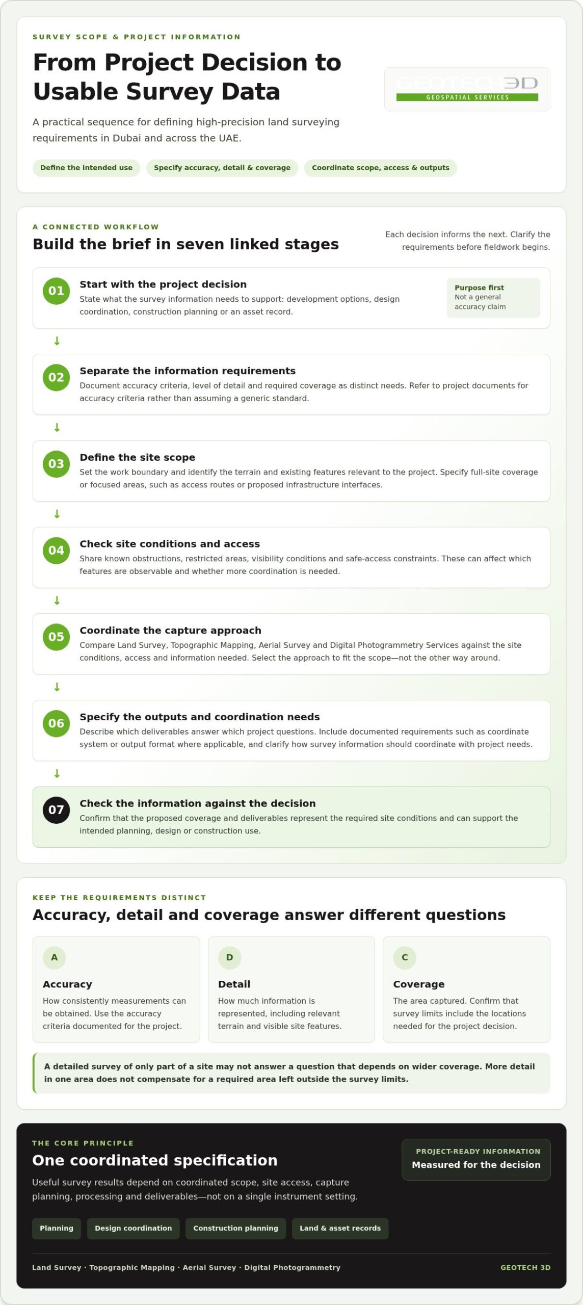
How to Prepare a Land Survey Brief for a Dubai or UAE Project
A clear brief starts with the decision the survey must support, not a preferred instrument or an assumed accuracy figure. This sequence helps developers, consultants, contractors and asset teams describe the work in practical terms. Share available site information and project documentation so the scope reflects site conditions and the intended use of the data.
Define the site, objective, and survey coverage
Set out the project purpose and the areas to be surveyed. Separate information needed for the current decision from optional context or possible future needs. This keeps the immediate scope focused while making clear which information belongs to a later project stage.
- Objective: State the decision the survey will support, such as site development planning, infrastructure design coordination or construction preparation. Name the intended users of the information.
- Site: Provide the location, available boundary information and plans or records that describe the site. Identify areas that are included, excluded or especially important to the project.
- Scope: Specify the information needed. This may relate to terrain, existing surface features, cadastral mapping or another defined requirement. Separate essential survey data from background material that is useful but not required.
- Access: Describe entry arrangements, restricted areas, active operations and site conditions that could affect fieldwork. Include relevant safety requirements and coordination contacts so access can be planned responsibly.
- Outputs: List required deliverables and formats when stated in project specifications. Include documented coordinate system or tolerance requirements rather than relying on assumptions or informal preferences.
- Coordination: Identify the design, construction and asset teams that will use the information, along with project interfaces or timing considerations that affect survey work. This helps align the scope with how the data will be reviewed and applied.
Set access, safety, coordination, and output requirements
Be specific about access. For example, note if parts of a development site are occupied, under active construction or accessible only through controlled entry. Describe relevant site safety procedures and operational constraints. These details help shape a workable field plan, but they do not replace the need to define the information the project requires.
For Dubai and UAE projects, tie requested outputs to project documents. If a consultant or design team has specified file formats, reference systems or tolerances, include them in the brief and identify the source document. If no requirement has been defined, avoid inserting an assumed technical value. GEOTECH 3D can align Land Survey or Topographic Mapping with the project’s stated scope and outputs. For information about these services, see GEOTECH 3D’s surveying services.
If the brief includes underground assets, identify them as a separate information need from surface survey coverage. Underground services require a distinct scope, such as utilities mapping and GPR. State this requirement clearly so subsurface information is not assumed to be part of a surface survey.
A well-structured brief makes high precision land surveying GCC work easier to align with project decisions, site access and deliverables. Define the purpose first, then document the site, scope, access, outputs and coordination requirements.
GEOTECH 3D Land Surveying in Dubai and the UAE
A well-defined survey brief gives the project team a practical basis for selecting services and information outputs. GEOTECH 3D provides GIS & Surveying Services in Dubai and across the UAE, including Topographic Mapping, Land Survey, Aerial Survey and Digital Photogrammetry Services. Each can be aligned with the site information a project needs instead of being treated as a one-size-fits-all package.
Surveying services aligned with project requirements
Topographic Mapping supports scopes that require terrain and relevant site features to be represented for planning or design coordination. Land Survey can be scoped around the land information required for a defined project objective. For both, set out the site, coverage, intended use and requested outputs so the work has a clear purpose.
Where a project calls for broader site coverage, Aerial Survey may be relevant. Digital Photogrammetry Services can contribute when image-derived information fits the site conditions and required deliverables. The suitable approach depends on the project scope, access and outputs needed by the team. GEOTECH 3D also provides Cadastral Mapping and Utility Mapping (GPR) for briefs that require those types of information. State these scopes distinctly, especially when a project needs both surface information and underground asset information.
GEOTECH 3D is professionally registered and licensed, with experience across the Middle East. The company emphasizes safety compliance and the ability to work under tight schedules. For high precision land surveying GCC projects, a considered process starts by defining the information need, then aligning the survey scope and capture approach with the project brief.
Move from a defined brief to a project discussion
Before a project discussion, gather the information that helps translate a requirement into a workable scope. This includes the site location and available boundary information, the decisions the survey must support, the areas and features to be covered, access restrictions and relevant safety requirements. Include project specifications for output formats, coordinate systems or tolerances where these have been defined. Current drawings and other available site information can also help clarify the scope.
Clear inputs help align survey information with design, construction and asset-team needs. They also distinguish essential deliverables from optional context, making the discussion more focused. GEOTECH 3D approaches survey requirements with attention to accurate data acquisition, safety and project coordination, tailoring the scope to the stated objectives and site conditions.
Bring your project objective, site information and required outputs together to begin a focused discussion about the appropriate survey scope in Dubai or the UAE.
Set Your Project Up for Confident Decisions
A survey brief can serve as a useful reference throughout a project, not just as an instruction for fieldwork. As teams make design and delivery decisions, keeping the intended use of survey information visible helps maintain alignment between the data collected and the work it needs to support. That clarity matters for high precision land surveying GCC projects, where requirements should be tied to the project rather than assumed from a generic specification.
Bring the project objective, site information and relevant requirements together before work begins. A focused discussion can turn those inputs into a survey scope your team can use, while helping identify information gaps early.
With a clear brief and a defined scope, your team has a stronger basis for using survey information in project decisions.
Frequently Asked Questions
What is the difference between a land survey and a topographic survey?
A Land Survey is scoped around required land measurements, while a topographic survey focuses on representing terrain and surface features. When reviewing a proposed deliverable, check whether it contains the information needed for the next design task. A team coordinating grading, for example, may need terrain represented in a way that can be compared with design information. Establish how the deliverable will be interpreted and used in the project workflow.
Can a topographic survey confirm legal property boundaries?
A topographic survey by itself should not be treated as legal confirmation of property boundaries. Its mapped features and the boundary information required for a legal or cadastral purpose are not automatically the same deliverable. If a project depends on a boundary decision, identify that requirement explicitly and establish which records and survey scope govern it. This matters before placing design elements near a site edge or relying on a boundary for a property-related decision.
How long does a high-precision land survey take?
Timing depends on the work defined for the site, so there is no single duration that applies to every project. For a high precision land surveying GCC project, scheduling may be influenced by the area and complexity, access arrangements, site activity, required coverage, capture approach and deliverables. Consider timing alongside the survey scope and project programme. If other teams need the data for a specific design milestone, identify that handover date early.
Can aerial surveying replace a land survey?
Not in every case. Aerial Survey may provide useful project information, but its outputs must be assessed against the specific measurements and features required. Aerial data may not resolve every detail at a constrained interface or in an area obscured from capture. Treat aerial data as a possible part of the survey approach, and define how the project team will assess whether the deliverables answer its design or planning questions.
Does a land survey include underground utility mapping?
Underground utility information should be identified as a specific requirement rather than assumed from a general Land Survey request. If buried services affect a proposed work zone, share available utility records and indicate which areas or design interfaces need attention. This helps coordinate the information with planned design or excavation activities. GEOTECH 3D provides Utility Mapping (GPR) for projects that require underground asset information as part of their survey planning.
What information should I provide before requesting a land survey?
Provide basic site and project details, the latest revision of relevant drawings, and a clear indication of which documents are current. If plans contain conflicting information, flag the discrepancy rather than choosing one version without noting it. Identify who will review the survey outputs and what project task follows that review. These details help prevent teams from working from superseded references or receiving information that does not fit the next stage of coordination.
What factors affect the cost of a land survey in Dubai?
Survey cost depends on the work required, not the service name alone. Scope area, site complexity, access conditions, requested detail, capture approach and deliverables all affect the effort involved. Coordination needs or additional survey requirements can also shape the scope. To support a project-specific assessment, distinguish essential deliverables from optional ones and provide current site information. This gives the survey team a clearer picture of the work involved.
Search Now
Error: Contact form not found.