

Our Services
Justifying the Cost of Digital Twin to Stakeholders: A 2026 Strategic Buying Guide
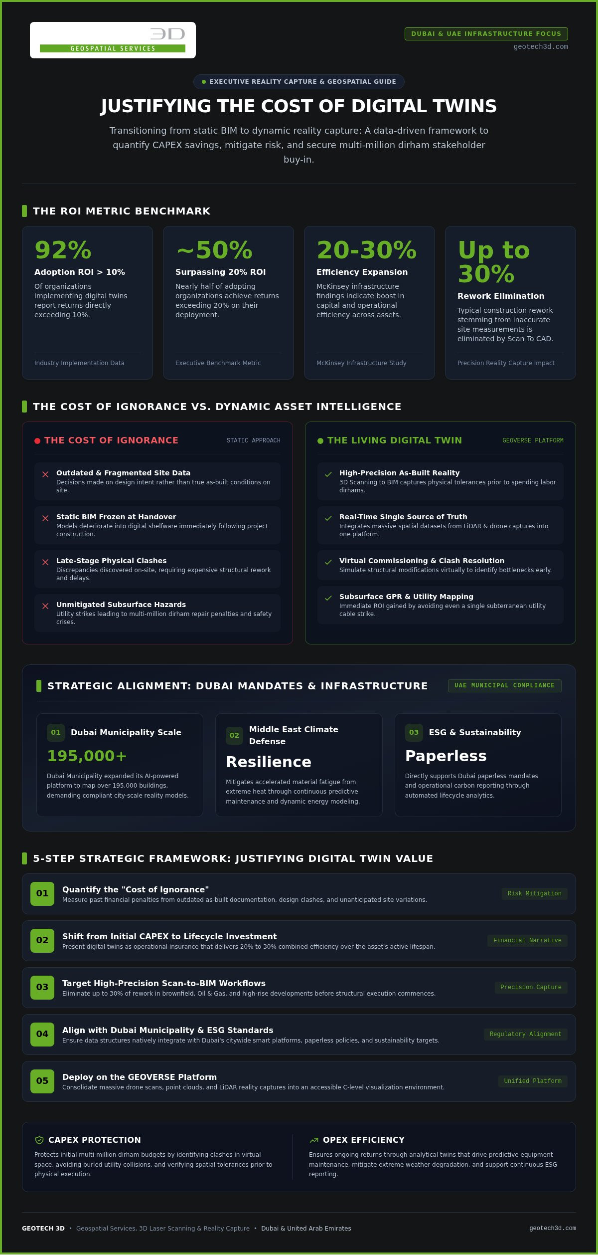
Did you know that 92% of organizations implementing digital twins now report an ROI exceeding 10%, with nearly half of those achieving returns over 20%? Despite these figures, many project managers in Dubai still struggle when justifying cost of digital twin to stakeholders who view high initial data acquisition as a luxury rather than a necessity. It’s a common challenge to quantify “soft” benefits like risk mitigation or long-term asset resilience during the early stages of a 2026 infrastructure project.
We understand that securing a multi-million dirham budget requires more than just a vision; it demands a rigorous, data-driven business case. This strategic guide provides you with a clear framework to master the financial narrative of reality capture. You’ll gain the confidence to present tangible cost-saving metrics and select a geospatial partner capable of delivering precision through the GEOVERSE Platform. We’ll examine how 3D Scanning To BIM and city-scale modeling serve as critical financial hedges against the budget overruns often seen in large-scale UAE developments, ensuring your project remains both compliant and profitable.
Key Takeaways
- Understand the 2026 transition from static BIM to dynamic, “living” data assets that deliver continuous value throughout the lifecycle of Dubai infrastructure projects.
- Learn a data-driven framework for justifying cost of digital twin to stakeholders by quantifying CAPEX savings and the long-term reduction of operational expenditure.
- Identify the “Cost of Ignorance” and how high-precision 3D Scanning To BIM mitigates the financial risks of working with outdated or inaccurate site data.
- Discover a 5-step strategic framework designed to align your digital twin business case with the specific requirements of the Dubai Municipality and UAE asset owners.
- Explore how the GEOVERSE Platform transforms complex reality capture data into a unified, actionable environment for executive-level decision-making.
Beyond Visualization: The Strategic Value of Digital Twins in Dubai
In 2026, a digital twin is no longer just a sophisticated 3D model used for presentations. It has evolved into a “living” data asset that mirrors the physical state of an infrastructure project in real time. For decision-makers in the UAE, the primary challenge lies in justifying cost of digital twin to stakeholders who may still view this as a purely visual luxury. To secure buy-in, you must redefine the conversation around data integrity and operational intelligence. While a visual twin offers a static representation, an analytical twin provides the actionable insights required to manage complex assets throughout their entire lifecycle.
The underlying digital twin technology provides a real-time bridge between physical assets and virtual environments. In Dubai’s rapid development sector, this connection is critical. Traditional BIM models are often static, frozen at the moment of construction handover. In contrast, the GEOVERSE Platform enables a transition to dynamic modeling, where massive spatial datasets from LiDAR and drone inspections are integrated into a single, accessible environment. This ensures that every stakeholder, from the CFO to the site engineer, works from a “single source of truth” that evolves alongside the building or facility.
The Evolution from Scan-to-BIM to Digital Twin
High-precision data acquisition is the bedrock of any reliable virtual model. At GEOTECH 3D, we utilize 3D Scanning To BIM to create a high-fidelity foundation that reflects as-built reality rather than design intent. This distinction is vital for brownfield projects in the Oil & Gas sector or high-rise refurbishments in Downtown Dubai. By moving beyond simple Scan To CAD workflows, the GEOVERSE Platform aggregates disparate data sources into a unified framework. It allows teams to visualize clashes, verify spatial tolerances, and simulate structural changes before a single dirham is spent on physical labor.
Aligning with UAE National Strategic Goals
Adopting advanced geospatial solutions isn’t just a corporate choice; it’s a strategic alignment with the UAE’s broader vision. Dubai Municipality recently expanded its AI-powered citywide platform, mapping over 195,000 buildings to support smart city management. By integrating your project into this ecosystem, you contribute to Dubai’s paperless initiatives and sustainability mandates. Digital twins are essential for enhancing asset longevity in the harsh Middle Eastern climate, where extreme heat can accelerate material fatigue. Through detailed energy modeling and predictive maintenance, these models support ESG reporting and ensure that infrastructure remains resilient for decades to come.
Quantifying ROI: Hard Metrics for UAE Infrastructure Projects
Proving the value of a digital twin requires shifting the financial perspective from “upfront cost” to “lifecycle investment.” A McKinsey infrastructure ROI study indicates that digital twin adoption can boost capital and operational efficiency by 20 to 30 percent. For project leads in Dubai, justifying cost of digital twin to stakeholders becomes significantly easier when these percentages are mapped against the multi-billion dirham budgets of UAE mega-projects. This isn’t just about better pictures; it’s about eliminating the “Cost of Ignorance,” which is the heavy financial penalty paid for making decisions based on outdated or fragmented site data.
Virtual commissioning and real-time data synchronization accelerate time-to-market by allowing teams to identify bottlenecks before they occur on-site. In the high-stakes environment of Dubai’s utility networks, the ROI of utilities mapping and GPR is often realized through a single avoided cable strike, preventing catastrophic repair costs and project delays. By investing in precision early, you protect the project from the cascading costs of unforeseen site conditions.
CAPEX Savings: Reducing Rework and Overruns
Construction overruns are frequently caused by discrepancies between design intent and actual site conditions. By utilizing high-precision Scan To CAD data, developers can eliminate up to 30% of typical rework that stems from inaccurate measurements. This level of precision streamlines several capital-heavy phases:
- Material Procurement: Volumetric surveys ensure that bulk material orders are based on exact site requirements, preventing waste and storage costs.
- Remote Monitoring: Drone services provide frequent, high-resolution progress updates, reducing the need for costly and time-consuming physical site inspections.
- Clash Detection: Identifying structural or MEP conflicts in a virtual environment before fabrication saves weeks of project delays.
OPEX Savings: The Long-Term Financial Case
The financial benefits of a digital twin extend far beyond the handover ceremony. Beyond the construction phase, justifying cost of digital twin to stakeholders relies heavily on the long-term operational expenditure (OPEX) savings. Predictive asset management allows for maintenance based on actual condition rather than arbitrary schedules. Using specialized drone sensors like the DJI Zenmuse H20T, facility managers can perform thermal anomaly detection to identify energy leaks or electrical faults before they lead to failure. In the Dubai real estate market, digital twins also streamline strata management and compliance by providing an indisputable record of floor areas and common property, ensuring fair and transparent service charge allocations.
Addressing Stakeholder Skepticism: Proving Value Across the Lifecycle
Skepticism often arises when stakeholders view a digital twin as a static, one-time deliverable rather than a dynamic operational process. To overcome this, you must pivot the conversation from technical specifications to risk management and long-term asset continuity. When justifying cost of digital twin to stakeholders, it’s essential to demonstrate how this technology addresses the specific anxieties of different executive roles, from the fiscal caution of the CFO to the schedule-driven focus of the Project Manager.
One of the most significant barriers to adoption is the fear of “data decay.” Stakeholders often worry that a high-fidelity model will become obsolete the moment a facility is modified. GEOTECH 3D mitigates this risk through a local maintenance model. Our established presence in Dubai and Abu Dhabi ensures that reality capture updates are performed periodically, keeping the digital twin synchronized with the physical asset. This commitment transforms the twin from a temporary snapshot into a permanent, reliable source of truth for the entire organization.
The CFO’s Perspective: Risk Mitigation and Insurance
CFOs prioritize fiscal stability and the reduction of long-term liabilities. In this context, a digital twin serves as an indisputable “insurance policy” for high-value infrastructure. For heritage sites or complex Oil & Gas facilities in the UAE, high-resolution 3D documentation provides a forensic record that is invaluable for insurance claims, dispute resolution, and restoration efforts. By utilizing drone services for confined space inspections, companies can significantly reduce health and safety risks. This doesn’t just protect personnel; it directly impacts the bottom line by lowering insurance premiums and preventing the catastrophic costs associated with workplace incidents or project litigation.
The Project Manager’s Perspective: Operational Efficiency
Project Managers are primarily concerned with maintaining schedules and fostering contractor coordination. A digital twin facilitates this by democratizing data through the GEOVERSE Platform. This environment allows non-technical stakeholders to access and interpret complex geospatial information without requiring specialized CAD or BIM training. This level of transparency leads to several tangible benefits:
- Remote Progress Monitoring: Stakeholders can conduct virtual site visits from their Dubai offices, reducing the time and expense of physical travel to remote project locations.
- Enhanced Collaboration: BIM-ready models ensure that consultants and contractors are working from identical datasets, which minimizes communication errors and design conflicts.
- Subsurface Certainty: Integrating GPR and utilities mapping into the twin prevents the unexpected utility strikes that frequently derail project timelines.
By providing a unified interface for disparate data sources, the GEOVERSE Platform ensures that the “Cost of Ignorance” is replaced by the “Value of Insight.” This transition is key to justifying cost of digital twin to stakeholders, as it proves that the investment pays for itself through avoided delays and optimized resource allocation across the project’s entire lifespan.
A 5-Step Framework for Building Your Digital Twin Business Case
Securing executive approval for a digital twin requires a methodical approach that connects technical capabilities to financial outcomes. In the competitive Dubai real estate and infrastructure markets, a vague proposal won’t suffice. You need a structured roadmap that addresses the logistical realities of 2026 projects. This 5-step framework simplifies the process of justifying cost of digital twin to stakeholders by aligning the technology with specific, high-stakes business objectives.
- Step 1: Define the High-Value Use Case. Start with a project where the cost of error is highest. This might be a complex Oil & Gas brownfield facility requiring precise modifications or a Dubai high-rise where spatial accuracy is critical for tenant fit-outs.
- Step 2: Audit Existing Data and Gap Analysis. Evaluate your current documentation. Most legacy projects rely on fragmented 2D drawings. A Scan-to-BIM gap analysis identifies where 3D Scanning To BIM is required to create a reliable foundation.
- Step 3: Select the Appropriate Reality Capture Technology. Match the tool to the environment. We utilize the Leica RTC 360 for sub-millimeter precision in dense MEP environments and the Navvis VLX 3 for rapid, high-quality capture of expansive commercial spaces.
- Step 4: Model the Financial Impact of Avoided Risks. Quantify the “Cost of Ignorance” discussed earlier. Calculate the potential savings from avoided utility strikes, reduced material waste, and the elimination of redundant site visits.
- Step 5: Define Data Governance and Update Frequency. A digital twin is only valuable if it’s current. Establish a schedule for periodic reality capture updates to ensure the model remains a “living” asset throughout the facility’s life.
Defining Scope and Technical Requirements
Precision levels significantly influence the initial investment. You must decide whether your project requires LOD 300 for general coordination or LOD 500 for comprehensive facility management. High-fidelity models are essential for complex assets, while simpler structures might only need visual documentation. Additionally, consider if your use case requires specialized sensors, such as thermal drone inspections for energy auditing or visual sensors for structural health monitoring. Understanding these requirements is vital for a Digital Twin for Asset Lifecycle strategy that delivers long-term value.
Selecting the Right Geospatial Partner in the UAE
The success of your business case depends on the reliability of your data partner. In the UAE, this means selecting a firm with local registration and a deep understanding of Middle East brownfield environments. Your partner must demonstrate strict safety compliance and the technical ability to deliver files compatible with your existing CAD and BIM software packages. GEOTECH 3D provides this localized expertise, ensuring that your data is not only accurate but also actionable within your specific organizational workflows.
Implementing with Precision: Why the GEOVERSE Platform is the Optimal Investment
The GEOVERSE Platform serves as the critical link between raw point cloud data and actionable executive insights. While high-precision data acquisition is the first step, the true value lies in how that data is processed, hosted, and presented to decision-makers. GEOTECH 3D has spent decades navigating the unique complexities of the UAE market, from high-stakes Oil & Gas facilities to the architectural marvels of Dubai. This local experience ensures that we don’t just deliver data; we deliver a strategic asset. By providing “BIM-ready” models, we enable immediate implementation, allowing your team to move from reality capture to project execution without the technical delays associated with data translation.
Justifying cost of digital twin to stakeholders becomes a straightforward task when you can demonstrate a platform that integrates seamlessly with existing enterprise workflows. The GEOVERSE Platform is designed for the 2026-2030 cycle, ensuring that your infrastructure remains future-proofed against evolving regulatory requirements and municipal standards in Dubai. It transforms massive spatial datasets into a navigable environment that even non-technical stakeholders can use to verify project status or assess asset health.
Unified Data Acquisition with GEOTECH 3D
Our approach to data acquisition is holistic, combining drone services, terrestrial laser scanning, and mobile LiDAR to create a comprehensive spatial record. This multi-sensor strategy is particularly effective in maritime and naval construction, where we offer specific accuracy guarantees for complex hull geometries and offshore structures. By integrating these disparate data streams into a single environment, we provide a level of precision that traditional surveying methods simply cannot match. For a deeper look at our technical workflows and how we handle complex data, refer to our 2026 Scan-to-BIM Guide.
Next Steps: From Proposal to Pilot
Transitioning to a digital twin environment doesn’t have to be an overnight overhaul of your entire operation. We often recommend initiating a pilot project to provide a tangible proof-of-concept for your specific use case. This allows you to demonstrate the ROI to internal skeptics using your own project data before committing to a city-scale or campus-wide deployment. GEOTECH 3D plays an active role in this transition, offering technical training and knowledge transfer to ensure your team is equipped to utilize the GEOVERSE Platform effectively. This partnership approach ensures that your investment continues to deliver value long after the initial scan is complete.
Our teams in Dubai and Abu Dhabi are ready to assist you in justifying cost of digital twin to stakeholders with data-backed evidence and real-world UAE examples. Whether you are managing a brownfield retrofit or a new infrastructure development, we provide the technical foundation required for success. Visit our Dubai office in Al Qusais or our Abu Dhabi office in Al Hisn to discuss your 2026 project requirements and see the GEOVERSE Platform in action.
Securing Your Infrastructure Legacy for the 2030 Horizon
The shift toward dynamic digital twins is no longer a technological trend but a strategic financial necessity for UAE asset owners. By moving beyond static documentation and adopting the GEOVERSE Platform, you transform raw data into a resilient asset that mitigates risk across the entire project lifecycle. Successfully justifying cost of digital twin to stakeholders requires this fundamental shift in perspective, moving from upfront expenditure to long-term value preservation and operational intelligence.
As a leading geospatial firm with a decade of expertise in the Middle East, we specialize in high-precision 3D models for complex environments like Oil & Gas brownfields. Our teams utilize cutting-edge technology, including the DJI Zenmuse H20T and Navvis VLX 3, to ensure your digital twin is built on a foundation of absolute accuracy. We provide the technical clarity needed to turn skeptical stakeholders into project champions.
It’s time to future-proof your assets and lead the next era of Dubai’s smart city evolution with confidence and precision.
Frequently Asked Questions
What is the typical ROI period for a digital twin in the UAE construction sector?
Most UAE organizations achieve a measurable return on investment within 6 to 12 months of operational deployment. This rapid recoupment is driven by the immediate reduction in rework and the mitigation of costly schedule overruns. By justifying cost of digital twin to stakeholders through these early wins, project managers can demonstrate that the technology pays for itself well before the final handover and continues to deliver value throughout the asset’s lifecycle.
How does a digital twin differ from a standard BIM model?
While a standard BIM model provides a static representation of design intent, a digital twin is a dynamic, “living” asset synchronized with reality. It integrates real-time data from sensors and periodic reality capture to reflect the current state of the facility. This evolution ensures that the model remains useful for operations and maintenance long after the construction phase, whereas traditional BIM models often become obsolete without constant manual updates.
Can the GEOVERSE Platform integrate with our existing ERP or GIS systems?
Yes, the GEOVERSE Platform is designed to function as a unified environment for multi-source geospatial data. It enables the integration of raw point clouds with existing GIS and ERP systems, providing a bridge between technical spatial data and corporate management tools. This interoperability is a key factor in justifying cost of digital twin to stakeholders, as it ensures the technology enhances, rather than disrupts, your established organizational workflows and decision-making processes.
What are the primary cost drivers when creating a digital twin for an oil and gas facility?
The primary cost drivers include the density of the facility’s piping and equipment, the required Level of Detail (LOD), and the accessibility of the site. High-fidelity modeling for complex brownfields requires specialized hardware like the Leica RTC 360 to capture sub-millimeter precision. The frequency of data updates and the integration of thermal or visual drone inspections for safety compliance also influence the total investment required for a reliable digital record.
How often does a digital twin need to be updated to remain valuable?
Update frequency depends on the pace of physical changes to the asset. For active construction sites in Dubai, weekly or monthly drone progress monitoring may be necessary. For operational facilities, updates are typically triggered by significant modifications or scheduled maintenance cycles. Regular reality capture ensures that the digital twin remains an accurate “single source of truth,” preventing the data decay that undermines the model’s reliability for stakeholders.
Does GEOTECH 3D provide the hardware or the service for 3D scanning?
GEOTECH 3D is a specialized geospatial services firm that provides end-to-end data acquisition and modeling solutions. We don’t sell hardware; instead, we utilize our own fleet of cutting-edge equipment, such as the Navvis VLX 3 and DJI Zenmuse H20T, to deliver high-precision results for our clients. Our service model includes everything from raw data capture and Scan-to-BIM processing to hosting models on the GEOVERSE Platform for executive-level analysis.
How do digital twins improve site safety for brownfield projects in Dubai?
Digital twins significantly enhance site safety by allowing for remote inspections of hazardous or hard-to-reach areas. Using drone services for confined space or flare-stick surveys removes personnel from high-risk environments. A highly accurate virtual model allows for better safety planning and simulation. This proactive approach reduces the likelihood of onsite accidents, which is a critical component of maintaining strict safety compliance in the UAE industrial and construction sectors.
What data security measures are in place for sensitive infrastructure models?
Data security is paramount for sensitive UAE infrastructure projects. The GEOVERSE Platform utilizes enterprise-grade encryption and secure hosting protocols to protect your spatial data from unauthorized access. We implement strict user access controls, ensuring that only authorized personnel can view or modify the digital twin. Our local presence in Dubai and Abu Dhabi also ensures that data management practices align with regional security requirements for high-stakes industries like Oil & Gas.
Did you know that 92% of organizations implementing digital twins now report an ROI exceeding 10%, with nearly half of those achieving returns over 20%? Despite these figures, many project managers in Dubai still struggle when justifying cost of digital twin to stakeholders who view high initial data acquisition as a luxury rather than a necessity. It’s a common challenge to quantify “soft” benefits like risk mitigation or long-term asset resilience during the early stages of a 2026 infrastructure project.
We understand that securing a multi-million dirham budget requires more than just a vision; it demands a rigorous, data-driven business case. This strategic guide provides you with a clear framework to master the financial narrative of reality capture. You’ll gain the confidence to present tangible cost-saving metrics and select a geospatial partner capable of delivering precision through the GEOVERSE Platform. We’ll examine how 3D Scanning To BIM and city-scale modeling serve as critical financial hedges against the budget overruns often seen in large-scale UAE developments, ensuring your project remains both compliant and profitable.
Key Takeaways
- Understand the 2026 transition from static BIM to dynamic, “living” data assets that deliver continuous value throughout the lifecycle of Dubai infrastructure projects.
- Learn a data-driven framework for justifying cost of digital twin to stakeholders by quantifying CAPEX savings and the long-term reduction of operational expenditure.
- Identify the “Cost of Ignorance” and how high-precision 3D Scanning To BIM mitigates the financial risks of working with outdated or inaccurate site data.
- Discover a 5-step strategic framework designed to align your digital twin business case with the specific requirements of the Dubai Municipality and UAE asset owners.
- Explore how the GEOVERSE Platform transforms complex reality capture data into a unified, actionable environment for executive-level decision-making.
Beyond Visualization: The Strategic Value of Digital Twins in Dubai
In 2026, a digital twin is no longer just a sophisticated 3D model used for presentations. It has evolved into a “living” data asset that mirrors the physical state of an infrastructure project in real time. For decision-makers in the UAE, the primary challenge lies in justifying cost of digital twin to stakeholders who may still view this as a purely visual luxury. To secure buy-in, you must redefine the conversation around data integrity and operational intelligence. While a visual twin offers a static representation, an analytical twin provides the actionable insights required to manage complex assets throughout their entire lifecycle.
The underlying digital twin technology provides a real-time bridge between physical assets and virtual environments. In Dubai’s rapid development sector, this connection is critical. Traditional BIM models are often static, frozen at the moment of construction handover. In contrast, the GEOVERSE Platform enables a transition to dynamic modeling, where massive spatial datasets from LiDAR and drone inspections are integrated into a single, accessible environment. This ensures that every stakeholder, from the CFO to the site engineer, works from a “single source of truth” that evolves alongside the building or facility.
The Evolution from Scan-to-BIM to Digital Twin
High-precision data acquisition is the bedrock of any reliable virtual model. At GEOTECH 3D, we utilize 3D Scanning To BIM to create a high-fidelity foundation that reflects as-built reality rather than design intent. This distinction is vital for brownfield projects in the Oil & Gas sector or high-rise refurbishments in Downtown Dubai. By moving beyond simple Scan To CAD workflows, the GEOVERSE Platform aggregates disparate data sources into a unified framework. It allows teams to visualize clashes, verify spatial tolerances, and simulate structural changes before a single dirham is spent on physical labor.
Aligning with UAE National Strategic Goals
Adopting advanced geospatial solutions isn’t just a corporate choice; it’s a strategic alignment with the UAE’s broader vision. Dubai Municipality recently expanded its AI-powered citywide platform, mapping over 195,000 buildings to support smart city management. By integrating your project into this ecosystem, you contribute to Dubai’s paperless initiatives and sustainability mandates. Digital twins are essential for enhancing asset longevity in the harsh Middle Eastern climate, where extreme heat can accelerate material fatigue. Through detailed energy modeling and predictive maintenance, these models support ESG reporting and ensure that infrastructure remains resilient for decades to come.
Quantifying ROI: Hard Metrics for UAE Infrastructure Projects
Proving the value of a digital twin requires shifting the financial perspective from “upfront cost” to “lifecycle investment.” A McKinsey infrastructure ROI study indicates that digital twin adoption can boost capital and operational efficiency by 20 to 30 percent. For project leads in Dubai, justifying cost of digital twin to stakeholders becomes significantly easier when these percentages are mapped against the multi-billion dirham budgets of UAE mega-projects. This isn’t just about better pictures; it’s about eliminating the “Cost of Ignorance,” which is the heavy financial penalty paid for making decisions based on outdated or fragmented site data.
Virtual commissioning and real-time data synchronization accelerate time-to-market by allowing teams to identify bottlenecks before they occur on-site. In the high-stakes environment of Dubai’s utility networks, the ROI of utilities mapping and GPR is often realized through a single avoided cable strike, preventing catastrophic repair costs and project delays. By investing in precision early, you protect the project from the cascading costs of unforeseen site conditions.
CAPEX Savings: Reducing Rework and Overruns
Construction overruns are frequently caused by discrepancies between design intent and actual site conditions. By utilizing high-precision Scan To CAD data, developers can eliminate up to 30% of typical rework that stems from inaccurate measurements. This level of precision streamlines several capital-heavy phases:
- Material Procurement: Volumetric surveys ensure that bulk material orders are based on exact site requirements, preventing waste and storage costs.
- Remote Monitoring: Drone services provide frequent, high-resolution progress updates, reducing the need for costly and time-consuming physical site inspections.
- Clash Detection: Identifying structural or MEP conflicts in a virtual environment before fabrication saves weeks of project delays.
OPEX Savings: The Long-Term Financial Case
The financial benefits of a digital twin extend far beyond the handover ceremony. Beyond the construction phase, justifying cost of digital twin to stakeholders relies heavily on the long-term operational expenditure (OPEX) savings. Predictive asset management allows for maintenance based on actual condition rather than arbitrary schedules. Using specialized drone sensors like the DJI Zenmuse H20T, facility managers can perform thermal anomaly detection to identify energy leaks or electrical faults before they lead to failure. In the Dubai real estate market, digital twins also streamline strata management and compliance by providing an indisputable record of floor areas and common property, ensuring fair and transparent service charge allocations.
Addressing Stakeholder Skepticism: Proving Value Across the Lifecycle
Skepticism often arises when stakeholders view a digital twin as a static, one-time deliverable rather than a dynamic operational process. To overcome this, you must pivot the conversation from technical specifications to risk management and long-term asset continuity. When justifying cost of digital twin to stakeholders, it’s essential to demonstrate how this technology addresses the specific anxieties of different executive roles, from the fiscal caution of the CFO to the schedule-driven focus of the Project Manager.
One of the most significant barriers to adoption is the fear of “data decay.” Stakeholders often worry that a high-fidelity model will become obsolete the moment a facility is modified. GEOTECH 3D mitigates this risk through a local maintenance model. Our established presence in Dubai and Abu Dhabi ensures that reality capture updates are performed periodically, keeping the digital twin synchronized with the physical asset. This commitment transforms the twin from a temporary snapshot into a permanent, reliable source of truth for the entire organization.
The CFO’s Perspective: Risk Mitigation and Insurance
CFOs prioritize fiscal stability and the reduction of long-term liabilities. In this context, a digital twin serves as an indisputable “insurance policy” for high-value infrastructure. For heritage sites or complex Oil & Gas facilities in the UAE, high-resolution 3D documentation provides a forensic record that is invaluable for insurance claims, dispute resolution, and restoration efforts. By utilizing drone services for confined space inspections, companies can significantly reduce health and safety risks. This doesn’t just protect personnel; it directly impacts the bottom line by lowering insurance premiums and preventing the catastrophic costs associated with workplace incidents or project litigation.
The Project Manager’s Perspective: Operational Efficiency
Project Managers are primarily concerned with maintaining schedules and fostering contractor coordination. A digital twin facilitates this by democratizing data through the GEOVERSE Platform. This environment allows non-technical stakeholders to access and interpret complex geospatial information without requiring specialized CAD or BIM training. This level of transparency leads to several tangible benefits:
- Remote Progress Monitoring: Stakeholders can conduct virtual site visits from their Dubai offices, reducing the time and expense of physical travel to remote project locations.
- Enhanced Collaboration: BIM-ready models ensure that consultants and contractors are working from identical datasets, which minimizes communication errors and design conflicts.
- Subsurface Certainty: Integrating GPR and utilities mapping into the twin prevents the unexpected utility strikes that frequently derail project timelines.
By providing a unified interface for disparate data sources, the GEOVERSE Platform ensures that the “Cost of Ignorance” is replaced by the “Value of Insight.” This transition is key to justifying cost of digital twin to stakeholders, as it proves that the investment pays for itself through avoided delays and optimized resource allocation across the project’s entire lifespan.
A 5-Step Framework for Building Your Digital Twin Business Case
Securing executive approval for a digital twin requires a methodical approach that connects technical capabilities to financial outcomes. In the competitive Dubai real estate and infrastructure markets, a vague proposal won’t suffice. You need a structured roadmap that addresses the logistical realities of 2026 projects. This 5-step framework simplifies the process of justifying cost of digital twin to stakeholders by aligning the technology with specific, high-stakes business objectives.
- Step 1: Define the High-Value Use Case. Start with a project where the cost of error is highest. This might be a complex Oil & Gas brownfield facility requiring precise modifications or a Dubai high-rise where spatial accuracy is critical for tenant fit-outs.
- Step 2: Audit Existing Data and Gap Analysis. Evaluate your current documentation. Most legacy projects rely on fragmented 2D drawings. A Scan-to-BIM gap analysis identifies where 3D Scanning To BIM is required to create a reliable foundation.
- Step 3: Select the Appropriate Reality Capture Technology. Match the tool to the environment. We utilize the Leica RTC 360 for sub-millimeter precision in dense MEP environments and the Navvis VLX 3 for rapid, high-quality capture of expansive commercial spaces.
- Step 4: Model the Financial Impact of Avoided Risks. Quantify the “Cost of Ignorance” discussed earlier. Calculate the potential savings from avoided utility strikes, reduced material waste, and the elimination of redundant site visits.
- Step 5: Define Data Governance and Update Frequency. A digital twin is only valuable if it’s current. Establish a schedule for periodic reality capture updates to ensure the model remains a “living” asset throughout the facility’s life.
Defining Scope and Technical Requirements
Precision levels significantly influence the initial investment. You must decide whether your project requires LOD 300 for general coordination or LOD 500 for comprehensive facility management. High-fidelity models are essential for complex assets, while simpler structures might only need visual documentation. Additionally, consider if your use case requires specialized sensors, such as thermal drone inspections for energy auditing or visual sensors for structural health monitoring. Understanding these requirements is vital for a Digital Twin for Asset Lifecycle strategy that delivers long-term value.
Selecting the Right Geospatial Partner in the UAE
The success of your business case depends on the reliability of your data partner. In the UAE, this means selecting a firm with local registration and a deep understanding of Middle East brownfield environments. Your partner must demonstrate strict safety compliance and the technical ability to deliver files compatible with your existing CAD and BIM software packages. GEOTECH 3D provides this localized expertise, ensuring that your data is not only accurate but also actionable within your specific organizational workflows.
Implementing with Precision: Why the GEOVERSE Platform is the Optimal Investment
The GEOVERSE Platform serves as the critical link between raw point cloud data and actionable executive insights. While high-precision data acquisition is the first step, the true value lies in how that data is processed, hosted, and presented to decision-makers. GEOTECH 3D has spent decades navigating the unique complexities of the UAE market, from high-stakes Oil & Gas facilities to the architectural marvels of Dubai. This local experience ensures that we don’t just deliver data; we deliver a strategic asset. By providing “BIM-ready” models, we enable immediate implementation, allowing your team to move from reality capture to project execution without the technical delays associated with data translation.
Justifying cost of digital twin to stakeholders becomes a straightforward task when you can demonstrate a platform that integrates seamlessly with existing enterprise workflows. The GEOVERSE Platform is designed for the 2026-2030 cycle, ensuring that your infrastructure remains future-proofed against evolving regulatory requirements and municipal standards in Dubai. It transforms massive spatial datasets into a navigable environment that even non-technical stakeholders can use to verify project status or assess asset health.
Unified Data Acquisition with GEOTECH 3D
Our approach to data acquisition is holistic, combining drone services, terrestrial laser scanning, and mobile LiDAR to create a comprehensive spatial record. This multi-sensor strategy is particularly effective in maritime and naval construction, where we offer specific accuracy guarantees for complex hull geometries and offshore structures. By integrating these disparate data streams into a single environment, we provide a level of precision that traditional surveying methods simply cannot match. For a deeper look at our technical workflows and how we handle complex data, refer to our 2026 Scan-to-BIM Guide.
Next Steps: From Proposal to Pilot
Transitioning to a digital twin environment doesn’t have to be an overnight overhaul of your entire operation. We often recommend initiating a pilot project to provide a tangible proof-of-concept for your specific use case. This allows you to demonstrate the ROI to internal skeptics using your own project data before committing to a city-scale or campus-wide deployment. GEOTECH 3D plays an active role in this transition, offering technical training and knowledge transfer to ensure your team is equipped to utilize the GEOVERSE Platform effectively. This partnership approach ensures that your investment continues to deliver value long after the initial scan is complete.
Our teams in Dubai and Abu Dhabi are ready to assist you in justifying cost of digital twin to stakeholders with data-backed evidence and real-world UAE examples. Whether you are managing a brownfield retrofit or a new infrastructure development, we provide the technical foundation required for success. Visit our Dubai office in Al Qusais or our Abu Dhabi office in Al Hisn to discuss your 2026 project requirements and see the GEOVERSE Platform in action.
Securing Your Infrastructure Legacy for the 2030 Horizon
The shift toward dynamic digital twins is no longer a technological trend but a strategic financial necessity for UAE asset owners. By moving beyond static documentation and adopting the GEOVERSE Platform, you transform raw data into a resilient asset that mitigates risk across the entire project lifecycle. Successfully justifying cost of digital twin to stakeholders requires this fundamental shift in perspective, moving from upfront expenditure to long-term value preservation and operational intelligence.
As a leading geospatial firm with a decade of expertise in the Middle East, we specialize in high-precision 3D models for complex environments like Oil & Gas brownfields. Our teams utilize cutting-edge technology, including the DJI Zenmuse H20T and Navvis VLX 3, to ensure your digital twin is built on a foundation of absolute accuracy. We provide the technical clarity needed to turn skeptical stakeholders into project champions.
It’s time to future-proof your assets and lead the next era of Dubai’s smart city evolution with confidence and precision.
Frequently Asked Questions
What is the typical ROI period for a digital twin in the UAE construction sector?
Most UAE organizations achieve a measurable return on investment within 6 to 12 months of operational deployment. This rapid recoupment is driven by the immediate reduction in rework and the mitigation of costly schedule overruns. By justifying cost of digital twin to stakeholders through these early wins, project managers can demonstrate that the technology pays for itself well before the final handover and continues to deliver value throughout the asset’s lifecycle.
How does a digital twin differ from a standard BIM model?
While a standard BIM model provides a static representation of design intent, a digital twin is a dynamic, “living” asset synchronized with reality. It integrates real-time data from sensors and periodic reality capture to reflect the current state of the facility. This evolution ensures that the model remains useful for operations and maintenance long after the construction phase, whereas traditional BIM models often become obsolete without constant manual updates.
Can the GEOVERSE Platform integrate with our existing ERP or GIS systems?
Yes, the GEOVERSE Platform is designed to function as a unified environment for multi-source geospatial data. It enables the integration of raw point clouds with existing GIS and ERP systems, providing a bridge between technical spatial data and corporate management tools. This interoperability is a key factor in justifying cost of digital twin to stakeholders, as it ensures the technology enhances, rather than disrupts, your established organizational workflows and decision-making processes.
What are the primary cost drivers when creating a digital twin for an oil and gas facility?
The primary cost drivers include the density of the facility’s piping and equipment, the required Level of Detail (LOD), and the accessibility of the site. High-fidelity modeling for complex brownfields requires specialized hardware like the Leica RTC 360 to capture sub-millimeter precision. The frequency of data updates and the integration of thermal or visual drone inspections for safety compliance also influence the total investment required for a reliable digital record.
How often does a digital twin need to be updated to remain valuable?
Update frequency depends on the pace of physical changes to the asset. For active construction sites in Dubai, weekly or monthly drone progress monitoring may be necessary. For operational facilities, updates are typically triggered by significant modifications or scheduled maintenance cycles. Regular reality capture ensures that the digital twin remains an accurate “single source of truth,” preventing the data decay that undermines the model’s reliability for stakeholders.
Does GEOTECH 3D provide the hardware or the service for 3D scanning?
GEOTECH 3D is a specialized geospatial services firm that provides end-to-end data acquisition and modeling solutions. We don’t sell hardware; instead, we utilize our own fleet of cutting-edge equipment, such as the Navvis VLX 3 and DJI Zenmuse H20T, to deliver high-precision results for our clients. Our service model includes everything from raw data capture and Scan-to-BIM processing to hosting models on the GEOVERSE Platform for executive-level analysis.
How do digital twins improve site safety for brownfield projects in Dubai?
Digital twins significantly enhance site safety by allowing for remote inspections of hazardous or hard-to-reach areas. Using drone services for confined space or flare-stick surveys removes personnel from high-risk environments. A highly accurate virtual model allows for better safety planning and simulation. This proactive approach reduces the likelihood of onsite accidents, which is a critical component of maintaining strict safety compliance in the UAE industrial and construction sectors.
What data security measures are in place for sensitive infrastructure models?
Data security is paramount for sensitive UAE infrastructure projects. The GEOVERSE Platform utilizes enterprise-grade encryption and secure hosting protocols to protect your spatial data from unauthorized access. We implement strict user access controls, ensuring that only authorized personnel can view or modify the digital twin. Our local presence in Dubai and Abu Dhabi also ensures that data management practices align with regional security requirements for high-stakes industries like Oil & Gas.
Search Now
Error: Contact form not found.