

Our Services
Managing Large Point Cloud Data Sets Through Formats and Workflows
The challenge with a point cloud isn’t just its size. It’s keeping the data usable from capture through delivery. Each point carries X, Y and Z coordinates, and a dataset can contain millions of points and grow to hundreds of gigabytes. Managing large point cloud data sets means choosing suitable formats, organizing files spatially and building a workflow for efficient access and processing.
If you work with scans of buildings, infrastructure or terrain, you know that greater detail can increase demands on storage, computing and coordination. A well-planned approach helps teams handle dense data while maintaining accuracy and meeting project requirements.
This article explains how point clouds are created, what compression formats such as LAZ and E57 contribute, and how capture and processing workflows shape data quality. It also explores spatial organization and management systems, including when cloud-based or on-site approaches can support project teams in Dubai and across the UAE.
Key Takeaways
- Choose a point cloud format based on whether your priority is retaining detail, reducing file size or preserving useful metadata.
- Plan capture, registration, quality control and model integration as connected stages to keep data reliable and usable.
- Spatial indexing methods, including Morton-based organization, can help structure points for efficient geographic access.
- Match your data management approach to project needs, balancing storage capacity, processing resources and team access.
- For projects in Dubai and across the UAE, GEOTECH 3D’s 3D Laser Scanning, Drone Services, topo survey and GIS & Surveying Services can support data acquisition and mapping requirements.
What is a Point Cloud?
A point cloud represents a three-dimensional object or surface as points with X, Y and Z coordinates. For example, a building scan records the locations of surfaces, edges and features throughout the captured space. Point cloud datasets may also include intensity values, colour information and classification labels. These attributes help distinguish materials, objects or ground points during later processing.
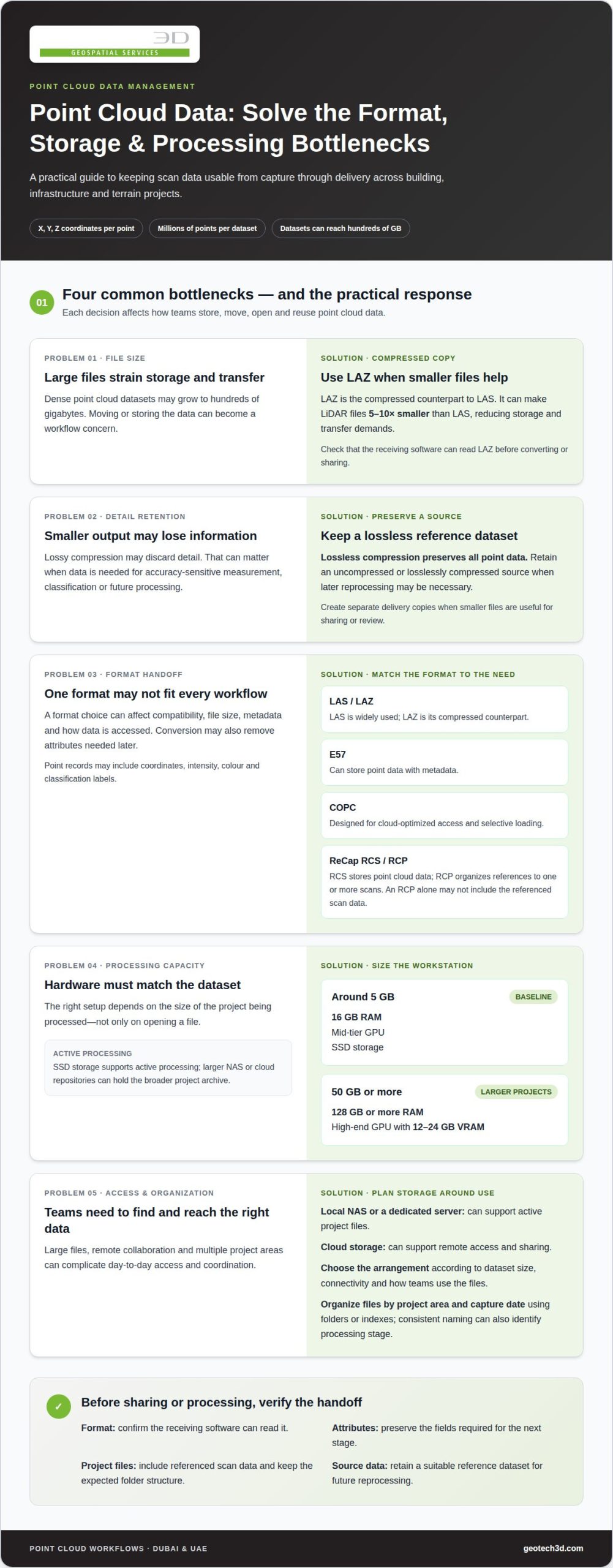
For storing and managing large datasets, LAS is a widely used format, while LAZ compresses LAS data and E57 can store point data with metadata. COPC is designed for cloud-optimized access, allowing point cloud data to be organized for selective loading. The suitable choice depends on whether the workflow prioritizes compatibility, smaller files, metadata or remote viewing.
File-based storage keeps scans in formats such as LAS, LAZ, E57 or COPC, with folders or indexes organizing project areas and capture dates. This model lets teams manage files directly and move selected datasets between systems. A database model instead stores points in a structured system; a flat relational design can assign each point its own row, while block storage groups points. Benchmarks have compared these approaches with file-based LAStools workflows, illustrating that the storage model affects how teams query and process data.
Storage capacity and transfer speed both shape daily access. Large point cloud datasets can reach hundreds of gigabytes, so a local network-attached storage system or dedicated server can support active project files. Storage planning should account for local capacity and transfer speeds, with requirements depending on project size and team workflow. Cloud storage can support remote access and sharing, while the best arrangement depends on dataset size, connectivity and how teams use the files.
Hardware must match the data being processed, not only the file being opened. For a small project around 5 GB, a baseline configuration may include 16 GB RAM, a mid-tier GPU and SSD storage. For projects of 50 GB or more, guidance points to 128 GB or more RAM and a high-end GPU with 12-24 GB VRAM. SSDs support active processing, while larger NAS or cloud repositories hold the broader project archive. These choices affect the workflow from import to visualization.
Compression techniques can reduce storage and transfer demands without changing the project’s spatial purpose. LAZ may make LiDAR files 5-10 times smaller than LAS files. Lossless compression retains the data, while lossy compression may discard detail. For accuracy-sensitive work, teams should preserve a suitable source dataset and select formats based on the intended models, software compatibility and sharing requirements.
Compression formats such as LAZ and E57
Compression changes how point data is encoded, while the format determines how applications store and interpret it. The format you choose affects transfer, compatibility and how teams can use the data.
Compression in Point Cloud Formats
Compression encodes point cloud information more compactly to support storage and transfer while retaining the data needed for the project. The key decision is whether to preserve every recorded value or accept reduced detail for a particular output.
Lossless compression preserves all point data; lossy compression may discard some detail. This distinction matters when datasets support accuracy-sensitive measurement, classification or future processing. For example, a photogrammetry dataset used to assess surface features may require different retention choices from a lightweight visualization shared for review. Keep an uncompressed or losslessly compressed source when later reprocessing may be necessary, and create separate delivery copies when smaller files are useful.
Choose a format based on the receiving software and the information your workflow needs. Point records may include coordinates, intensity, colour and classification labels. If conversion removes attributes needed for analysis, a smaller file may be less useful. Treat format conversion as a data-management decision, not just a compression task.
LAS and LAZ File Formats
LAS is a widely used point cloud format, and LAZ is its compressed counterpart. LAZ compression can make LiDAR files 5-10 times smaller than LAS files, helping reduce storage and transfer demands.
Use LAS when an uncompressed exchange file suits the receiving workflow, or LAZ when reducing file size is a priority and compatible software can read it. Both formats are commonly used for LiDAR data, including records with classification information. Before conversion, identify which point attributes and coordinate details must be preserved. Afterward, confirm that the output opens correctly and retains the fields required for the next processing stage.
For example, a surveying team can retain a source LAS dataset and distribute LAZ copies for routine access. This separates preservation from day-to-day transfer and clarifies version control: the source remains the reference, while processed copies can be named by area, capture date or processing stage. Consistent naming helps teams find the right file without changing the data itself.
ReCap RCS and RCP Formats
Autodesk ReCap uses RCS and RCP formats for point cloud projects in Autodesk workflows. RCS files store point cloud data, while an RCP project file organizes references to one or more scans.
This distinction matters when sharing a ReCap project: an RCP file alone may not include the referenced scan data. Package the project file with its associated RCS data, and preserve the folder structure expected by the receiving workflow. For a multi-scan building model, this organization maintains the relationship between the project and its source scans.
RCS and RCP can suit teams working in Autodesk applications, while LAS, LAZ or E57 may better fit other exchange needs. Select a delivery format by checking the intended software, required attributes and whether recipients need editable source data or a project-specific package. A format matrix for each project can record those decisions and reduce avoidable conversion steps.
Point cloud capture and processing workflows
A reliable workflow moves from capture through registration, cleaning, tiling, indexing and validation, then on to visualization or model integration. These steps keep dense engineering data usable while preserving the detail needed to represent structures and site conditions.
Cleaning and Optimizing Point Cloud Data
Cleaning removes noise and unwanted points, while optimization prepares a dataset for its intended processing and viewing tasks. Both are important: stray returns or excessive detail can slow analysis and obscure useful features.
Start by reviewing the captured laser scan, filtering noise and checking the remaining points against project requirements. Registration aligns individual scans into one coordinated dataset. Quality-control checks at each stage help identify misalignment or incomplete coverage before model integration. For example, a scan for broad site visualization may not need every point retained at maximum density. Preserve the detail needed for the engineering decisions at hand.
Tiling and Indexing Workflows
Tiling divides a large point cloud into spatially defined sections, while indexing records where to find those sections. Together, they let teams load and process relevant areas instead of repeatedly handling the entire dataset.
For a road corridor, tiles can follow geographic segments, allowing teams to inspect one work area without loading distant sections. Indexing links each tile to its location and available attributes. Set tile boundaries to match the project’s spatial coverage and downstream tasks. Consistent names based on location or processing stage also help engineers identify the right section during review and coordination.
Automated Batch Processing
Batch processing applies the same operations to multiple files, instead of requiring separate manual handling for each scan. This is useful when many scans need similar preparation.
Tools such as CloudCompare can support point cloud processing and visualization. A batch workflow can apply defined filtering or conversion operations across multiple files, then produce outputs for review. Build quality checks into the workflow: inspect representative results, confirm registration and review attributes such as classification before using processed data. Automation reduces repetitive handling, but it does not replace validation.
Processing Resources and Real-Time Visualization
Dense point cloud processing requires computing resources suited to the dataset size and task. RAM supports data loading, a dedicated GPU can assist with visualization and processing, and SSD storage supports active files.
For large projects of 50 GB or more, guidance recommends 128 GB or more RAM and a high-end GPU with 12-24 GB VRAM. Point cloud streaming loads data in increments, reducing memory demand and improving responsiveness during visualization. Potree can present large datasets through web-based viewing workflows, while CloudCompare supports inspection and operations such as sectioning. Match the processing setup to the required output, whether reviewing structures or preparing data for engineering models.
Space-filling curves and Morton-based organization
Spatial organization links each point or tile to its location, helping teams find relevant areas efficiently. Space-filling curves and Morton ordering are methods for arranging spatial data to support indexing and access.
For UAE projects, storage and sharing controls depend on project agreements, data ownership, licensing terms and hosting arrangements. Record permitted users, uses and exchange formats in the project’s data-management plan, and follow relevant contractual and organizational requirements.
Organize and catalog point cloud datasets by spatial extent, capture date, source, coordinate reference information and processing status. Link these catalog details to tiles or files through a spatial index, so the team can locate an object or area without opening every dataset.
How Morton Ordering Supports Spatial Access
A space-filling curve maps positions in several dimensions to a one-dimensional sequence while keeping nearby locations relatively close in that sequence. Morton ordering, also called Z-order, interleaves coordinate bits to give each spatial location a sortable code.
For example, a project can divide a site into tiles, assign each tile a Morton code, then sort the index by those codes. A query for one region can use the spatial index to identify nearby tile codes and retrieve only relevant data. This supports selective access; it neither changes captured coordinates nor replaces coordinate reference information.
Set tile size and catalog fields according to how the engineering team will use the data. A corridor project may organize tiles along its route, while a building project may group them by floor or zone. Consistent naming, metadata and indexing make it easier to trace each tile to its source scan and processing status.
Cloud Collaboration and Data Exchange
Cloud-based processing can support scalable access and collaboration among multiple users. On-site processing relies on local computing resources and typically limits sharing. The right model depends on dataset size, connectivity, processing needs and how project participants access the information.
A cloud workflow can let a survey team generate an indexed dataset and share selected spatial areas with engineering colleagues. Streaming or selective tile access can reduce the need to transfer the entire point cloud for every review. On-site processing can suit workflows that rely on local infrastructure; teams can then exchange defined deliverables through an agreed project channel.
Before sharing, catalog the dataset’s coverage, source, coordinate reference information, classification and processing state. These details help recipients understand what they are receiving and how it fits their models. Keep the catalog and file references aligned when data moves between on-site storage and cloud environments.
For a Dubai development, a structured exchange could identify building zones, scan sources and the purpose of the review. A clear index helps collaborators access relevant areas, while documented permissions and licensing terms establish how they may use shared data.
Point cloud data management systems
A management system should make datasets traceable from capture through review, delivery and later reuse. Its catalog can link each file to a project, site area, source, processing stage, responsible team and intended use. Managing large point cloud data sets effectively means making their context searchable, not just their file names.
How the Management Architecture Fits Together
Think of the system as a project record built around the data. A catalog describes files and how they relate, while the storage layer holds source scans and approved derivatives. Search fields can include project identifier, location, capture date, coordinate reference information, classification and status. Teams can then find records by project context instead of browsing folders manually.
Define a consistent metadata schema before adding new datasets to the repository. For example, standardize status terms for captured, registered, reviewed and issued data. Record file relationships when a source scan produces multiple processed outputs. This lineage helps users identify which version supports a particular model or decision and provides a clearer audit trail at handover.
Build a Reliable Project Record
Give each dataset a stable identifier and use it consistently across the catalog, storage locations and delivery records. For example, a facility scan can use the same project and area identifiers in its catalog entry and handover documentation. This reduces ambiguity when teams use different naming conventions or revisit records after a project phase has closed.
Management controls should distinguish working files from approved deliverables. Record who changed a dataset, its processing stage and which team reviewed it. These records make it easier to trace a result to its source and determine whether it suits the intended task.
Access, Governance and Long-Term Use
Set permissions according to project roles and data purpose. A design reviewer may need access to issued deliverables, while a data manager may oversee source files and version records. Document naming conventions, retention decisions and licensing terms alongside the catalog, so access and reuse follow the project’s agreed controls.
For a Dubai construction project, a well-maintained catalog can connect point cloud records to project areas, deliverable status and responsible teams. GEOTECH 3D’s geospatial data acquisition services can support project requirements for accurate spatial information.
GEOTECH 3D
GEOTECH 3D supports project teams in Dubai and across the UAE with geospatial data acquisition and mapping services. When point cloud work begins with a clear understanding of site coverage, required detail and intended use, the resulting data can better support engineering and asset decisions. GEOTECH 3D’s topo survey, 3D Laser Scanning, Drone Services, and GIS & Surveying Services can contribute to capturing and organizing spatial information for project workflows.
Turn to GEOTECH 3D when your project needs reliable site data for planning, existing-condition documentation or mapping. Share the project area, intended application and relevant deliverable requirements to help define a suitable approach to data capture.
Contact GEOTECH 3D to discuss your point cloud data requirements.
Make Data Stewardship Part of the Next Project
Make point cloud governance part of project planning, rather than postponing it until files accumulate. Define who needs access, which deliverables must remain traceable and how the data will support design, construction or operations. These decisions give technical choices a clear purpose and help maintain continuity through project handovers.
For teams working across Dubai and the UAE, managing large point cloud data sets is an ongoing information-management responsibility. Establish ownership, access and intended use early to help carry useful spatial information forward as project needs evolve. These decisions also clarify what to retain, share or prepare for future work.
At your next project milestone, align data management with the decisions the point cloud must support. A considered approach can help teams build dependable workflows and make better use of captured information over time.
With a clear plan, point cloud data can remain a practical resource as the project progresses.
Frequently Asked Questions
What is a point cloud and what makes large point cloud datasets difficult to manage?
A point cloud is a digital record of measured locations used to represent real-world spaces or objects. Management challenges often arise when coordinating files captured at different times, across different areas and for different project purposes. Teams need to distinguish survey source data from review copies and deliverables. Clear identifiers and a record of each file’s role help prevent confusion during design coordination and handover.
How much storage do large point cloud datasets require per million points or per terabyte?
There’s no reliable way to estimate storage needs from point count alone. File size depends on the attributes recorded for each point, coordinate encoding, format and compression settings. Measure representative source files from the project, then estimate across the expected coverage and capture scope. Include space for working versions, exports and retained source data. This project-based estimate is more useful than a generic figure per million points.
What tools and software can manage, view, process, and share large point cloud datasets?
Choose software based on the tasks it must support: format import, attribute preservation, registration, editing, visualization, spatial search or controlled delivery. For a project team, interoperability matters as much as individual features. Test a representative sample through the intended workflow, including export and handover, before adopting a toolchain. This reveals whether coordinates, classifications and other required information remain usable across the applications involved.
How do point cloud compression methods compare in file size, speed, and data quality?
Compression performance depends on the encoding method, dataset characteristics and processing environment. Lossless methods preserve recorded information; lossy methods trade some detail for a smaller output. Processing speed also varies with the operation and receiving software. Compare methods using a representative project sample, measuring output size, processing time and whether the result supports its intended task. Keep the source available if later analysis may require full detail.
What hardware and cloud infrastructure are needed to process and serve large point cloud datasets?
Assess infrastructure against the actual workload: simultaneous users, processing operations, visualization needs and transfer volumes. A review-only workload differs from registration or repeated analysis. Test a representative project segment and observe responsiveness during the operations users perform most often. For hosted environments, consider data-transfer paths and how users access the service. This workload profile helps define a practical configuration without relying on generic hardware specifications.
How can point cloud data be backed up, secured, and shared across teams?
Establish a backup plan for source captures, project records and approved outputs, then test whether files can be restored. Set access permissions by role and use named project folders or repositories to limit accidental changes. Before sharing, identify recipients, permitted use and the authoritative version. A documented handover record can state which files were issued, their status and the project area they cover.
What are the risks of downsampling or compressing point cloud data, and how can accuracy be preserved?
Downsampling can remove small features or narrow gaps needed for a particular measurement, while lossy compression can discard recorded detail. Preserve an untouched source and assess reduced versions against the smallest feature the task must resolve. A visualization copy, for example, may suit broad review but not detailed measurement. Record processing choices and intended use for each derivative so teams select data appropriate to their decisions.
How do on-premises and cloud-based point cloud management compare in cost and performance?
Compare total operating requirements, not just purchase or hosting charges. Local deployments require maintaining storage, computing and network capacity; hosted services may involve recurring usage and data-transfer charges. Performance depends on workload, data and user locations, and transfer conditions. Estimate costs using expected project activity, test typical tasks and review access patterns. A suitable choice balances operational control, responsiveness and ongoing resource needs.

The challenge with a point cloud isn’t just its size. It’s keeping the data usable from capture through delivery. Each point carries X, Y and Z coordinates, and a dataset can contain millions of points and grow to hundreds of gigabytes. Managing large point cloud data sets means choosing suitable formats, organizing files spatially and building a workflow for efficient access and processing.
If you work with scans of buildings, infrastructure or terrain, you know that greater detail can increase demands on storage, computing and coordination. A well-planned approach helps teams handle dense data while maintaining accuracy and meeting project requirements.
This article explains how point clouds are created, what compression formats such as LAZ and E57 contribute, and how capture and processing workflows shape data quality. It also explores spatial organization and management systems, including when cloud-based or on-site approaches can support project teams in Dubai and across the UAE.
Key Takeaways
- Choose a point cloud format based on whether your priority is retaining detail, reducing file size or preserving useful metadata.
- Plan capture, registration, quality control and model integration as connected stages to keep data reliable and usable.
- Spatial indexing methods, including Morton-based organization, can help structure points for efficient geographic access.
- Match your data management approach to project needs, balancing storage capacity, processing resources and team access.
- For projects in Dubai and across the UAE, GEOTECH 3D’s 3D Laser Scanning, Drone Services, topo survey and GIS & Surveying Services can support data acquisition and mapping requirements.
What is a Point Cloud?
A point cloud represents a three-dimensional object or surface as points with X, Y and Z coordinates. For example, a building scan records the locations of surfaces, edges and features throughout the captured space. Point cloud datasets may also include intensity values, colour information and classification labels. These attributes help distinguish materials, objects or ground points during later processing.
For storing and managing large datasets, LAS is a widely used format, while LAZ compresses LAS data and E57 can store point data with metadata. COPC is designed for cloud-optimized access, allowing point cloud data to be organized for selective loading. The suitable choice depends on whether the workflow prioritizes compatibility, smaller files, metadata or remote viewing.
File-based storage keeps scans in formats such as LAS, LAZ, E57 or COPC, with folders or indexes organizing project areas and capture dates. This model lets teams manage files directly and move selected datasets between systems. A database model instead stores points in a structured system; a flat relational design can assign each point its own row, while block storage groups points. Benchmarks have compared these approaches with file-based LAStools workflows, illustrating that the storage model affects how teams query and process data.
Storage capacity and transfer speed both shape daily access. Large point cloud datasets can reach hundreds of gigabytes, so a local network-attached storage system or dedicated server can support active project files. Storage planning should account for local capacity and transfer speeds, with requirements depending on project size and team workflow. Cloud storage can support remote access and sharing, while the best arrangement depends on dataset size, connectivity and how teams use the files.
Hardware must match the data being processed, not only the file being opened. For a small project around 5 GB, a baseline configuration may include 16 GB RAM, a mid-tier GPU and SSD storage. For projects of 50 GB or more, guidance points to 128 GB or more RAM and a high-end GPU with 12-24 GB VRAM. SSDs support active processing, while larger NAS or cloud repositories hold the broader project archive. These choices affect the workflow from import to visualization.
Compression techniques can reduce storage and transfer demands without changing the project’s spatial purpose. LAZ may make LiDAR files 5-10 times smaller than LAS files. Lossless compression retains the data, while lossy compression may discard detail. For accuracy-sensitive work, teams should preserve a suitable source dataset and select formats based on the intended models, software compatibility and sharing requirements.
Compression formats such as LAZ and E57
Compression changes how point data is encoded, while the format determines how applications store and interpret it. The format you choose affects transfer, compatibility and how teams can use the data.
Compression in Point Cloud Formats
Compression encodes point cloud information more compactly to support storage and transfer while retaining the data needed for the project. The key decision is whether to preserve every recorded value or accept reduced detail for a particular output.
Lossless compression preserves all point data; lossy compression may discard some detail. This distinction matters when datasets support accuracy-sensitive measurement, classification or future processing. For example, a photogrammetry dataset used to assess surface features may require different retention choices from a lightweight visualization shared for review. Keep an uncompressed or losslessly compressed source when later reprocessing may be necessary, and create separate delivery copies when smaller files are useful.
Choose a format based on the receiving software and the information your workflow needs. Point records may include coordinates, intensity, colour and classification labels. If conversion removes attributes needed for analysis, a smaller file may be less useful. Treat format conversion as a data-management decision, not just a compression task.
LAS and LAZ File Formats
LAS is a widely used point cloud format, and LAZ is its compressed counterpart. LAZ compression can make LiDAR files 5-10 times smaller than LAS files, helping reduce storage and transfer demands.
Use LAS when an uncompressed exchange file suits the receiving workflow, or LAZ when reducing file size is a priority and compatible software can read it. Both formats are commonly used for LiDAR data, including records with classification information. Before conversion, identify which point attributes and coordinate details must be preserved. Afterward, confirm that the output opens correctly and retains the fields required for the next processing stage.
For example, a surveying team can retain a source LAS dataset and distribute LAZ copies for routine access. This separates preservation from day-to-day transfer and clarifies version control: the source remains the reference, while processed copies can be named by area, capture date or processing stage. Consistent naming helps teams find the right file without changing the data itself.
ReCap RCS and RCP Formats
Autodesk ReCap uses RCS and RCP formats for point cloud projects in Autodesk workflows. RCS files store point cloud data, while an RCP project file organizes references to one or more scans.
This distinction matters when sharing a ReCap project: an RCP file alone may not include the referenced scan data. Package the project file with its associated RCS data, and preserve the folder structure expected by the receiving workflow. For a multi-scan building model, this organization maintains the relationship between the project and its source scans.
RCS and RCP can suit teams working in Autodesk applications, while LAS, LAZ or E57 may better fit other exchange needs. Select a delivery format by checking the intended software, required attributes and whether recipients need editable source data or a project-specific package. A format matrix for each project can record those decisions and reduce avoidable conversion steps.
Point cloud capture and processing workflows
A reliable workflow moves from capture through registration, cleaning, tiling, indexing and validation, then on to visualization or model integration. These steps keep dense engineering data usable while preserving the detail needed to represent structures and site conditions.
Cleaning and Optimizing Point Cloud Data
Cleaning removes noise and unwanted points, while optimization prepares a dataset for its intended processing and viewing tasks. Both are important: stray returns or excessive detail can slow analysis and obscure useful features.
Start by reviewing the captured laser scan, filtering noise and checking the remaining points against project requirements. Registration aligns individual scans into one coordinated dataset. Quality-control checks at each stage help identify misalignment or incomplete coverage before model integration. For example, a scan for broad site visualization may not need every point retained at maximum density. Preserve the detail needed for the engineering decisions at hand.
Tiling and Indexing Workflows
Tiling divides a large point cloud into spatially defined sections, while indexing records where to find those sections. Together, they let teams load and process relevant areas instead of repeatedly handling the entire dataset.
For a road corridor, tiles can follow geographic segments, allowing teams to inspect one work area without loading distant sections. Indexing links each tile to its location and available attributes. Set tile boundaries to match the project’s spatial coverage and downstream tasks. Consistent names based on location or processing stage also help engineers identify the right section during review and coordination.
Automated Batch Processing
Batch processing applies the same operations to multiple files, instead of requiring separate manual handling for each scan. This is useful when many scans need similar preparation.
Tools such as CloudCompare can support point cloud processing and visualization. A batch workflow can apply defined filtering or conversion operations across multiple files, then produce outputs for review. Build quality checks into the workflow: inspect representative results, confirm registration and review attributes such as classification before using processed data. Automation reduces repetitive handling, but it does not replace validation.
Processing Resources and Real-Time Visualization
Dense point cloud processing requires computing resources suited to the dataset size and task. RAM supports data loading, a dedicated GPU can assist with visualization and processing, and SSD storage supports active files.
For large projects of 50 GB or more, guidance recommends 128 GB or more RAM and a high-end GPU with 12-24 GB VRAM. Point cloud streaming loads data in increments, reducing memory demand and improving responsiveness during visualization. Potree can present large datasets through web-based viewing workflows, while CloudCompare supports inspection and operations such as sectioning. Match the processing setup to the required output, whether reviewing structures or preparing data for engineering models.
Space-filling curves and Morton-based organization
Spatial organization links each point or tile to its location, helping teams find relevant areas efficiently. Space-filling curves and Morton ordering are methods for arranging spatial data to support indexing and access.
For UAE projects, storage and sharing controls depend on project agreements, data ownership, licensing terms and hosting arrangements. Record permitted users, uses and exchange formats in the project’s data-management plan, and follow relevant contractual and organizational requirements.
Organize and catalog point cloud datasets by spatial extent, capture date, source, coordinate reference information and processing status. Link these catalog details to tiles or files through a spatial index, so the team can locate an object or area without opening every dataset.
How Morton Ordering Supports Spatial Access
A space-filling curve maps positions in several dimensions to a one-dimensional sequence while keeping nearby locations relatively close in that sequence. Morton ordering, also called Z-order, interleaves coordinate bits to give each spatial location a sortable code.
For example, a project can divide a site into tiles, assign each tile a Morton code, then sort the index by those codes. A query for one region can use the spatial index to identify nearby tile codes and retrieve only relevant data. This supports selective access; it neither changes captured coordinates nor replaces coordinate reference information.
Set tile size and catalog fields according to how the engineering team will use the data. A corridor project may organize tiles along its route, while a building project may group them by floor or zone. Consistent naming, metadata and indexing make it easier to trace each tile to its source scan and processing status.
Cloud Collaboration and Data Exchange
Cloud-based processing can support scalable access and collaboration among multiple users. On-site processing relies on local computing resources and typically limits sharing. The right model depends on dataset size, connectivity, processing needs and how project participants access the information.
A cloud workflow can let a survey team generate an indexed dataset and share selected spatial areas with engineering colleagues. Streaming or selective tile access can reduce the need to transfer the entire point cloud for every review. On-site processing can suit workflows that rely on local infrastructure; teams can then exchange defined deliverables through an agreed project channel.
Before sharing, catalog the dataset’s coverage, source, coordinate reference information, classification and processing state. These details help recipients understand what they are receiving and how it fits their models. Keep the catalog and file references aligned when data moves between on-site storage and cloud environments.
For a Dubai development, a structured exchange could identify building zones, scan sources and the purpose of the review. A clear index helps collaborators access relevant areas, while documented permissions and licensing terms establish how they may use shared data.
Point cloud data management systems
A management system should make datasets traceable from capture through review, delivery and later reuse. Its catalog can link each file to a project, site area, source, processing stage, responsible team and intended use. Managing large point cloud data sets effectively means making their context searchable, not just their file names.
How the Management Architecture Fits Together
Think of the system as a project record built around the data. A catalog describes files and how they relate, while the storage layer holds source scans and approved derivatives. Search fields can include project identifier, location, capture date, coordinate reference information, classification and status. Teams can then find records by project context instead of browsing folders manually.
Define a consistent metadata schema before adding new datasets to the repository. For example, standardize status terms for captured, registered, reviewed and issued data. Record file relationships when a source scan produces multiple processed outputs. This lineage helps users identify which version supports a particular model or decision and provides a clearer audit trail at handover.
Build a Reliable Project Record
Give each dataset a stable identifier and use it consistently across the catalog, storage locations and delivery records. For example, a facility scan can use the same project and area identifiers in its catalog entry and handover documentation. This reduces ambiguity when teams use different naming conventions or revisit records after a project phase has closed.
Management controls should distinguish working files from approved deliverables. Record who changed a dataset, its processing stage and which team reviewed it. These records make it easier to trace a result to its source and determine whether it suits the intended task.
Access, Governance and Long-Term Use
Set permissions according to project roles and data purpose. A design reviewer may need access to issued deliverables, while a data manager may oversee source files and version records. Document naming conventions, retention decisions and licensing terms alongside the catalog, so access and reuse follow the project’s agreed controls.
For a Dubai construction project, a well-maintained catalog can connect point cloud records to project areas, deliverable status and responsible teams. GEOTECH 3D’s geospatial data acquisition services can support project requirements for accurate spatial information.
GEOTECH 3D
GEOTECH 3D supports project teams in Dubai and across the UAE with geospatial data acquisition and mapping services. When point cloud work begins with a clear understanding of site coverage, required detail and intended use, the resulting data can better support engineering and asset decisions. GEOTECH 3D’s topo survey, 3D Laser Scanning, Drone Services, and GIS & Surveying Services can contribute to capturing and organizing spatial information for project workflows.
Turn to GEOTECH 3D when your project needs reliable site data for planning, existing-condition documentation or mapping. Share the project area, intended application and relevant deliverable requirements to help define a suitable approach to data capture.
Contact GEOTECH 3D to discuss your point cloud data requirements.
Make Data Stewardship Part of the Next Project
Make point cloud governance part of project planning, rather than postponing it until files accumulate. Define who needs access, which deliverables must remain traceable and how the data will support design, construction or operations. These decisions give technical choices a clear purpose and help maintain continuity through project handovers.
For teams working across Dubai and the UAE, managing large point cloud data sets is an ongoing information-management responsibility. Establish ownership, access and intended use early to help carry useful spatial information forward as project needs evolve. These decisions also clarify what to retain, share or prepare for future work.
At your next project milestone, align data management with the decisions the point cloud must support. A considered approach can help teams build dependable workflows and make better use of captured information over time.
With a clear plan, point cloud data can remain a practical resource as the project progresses.
Frequently Asked Questions
What is a point cloud and what makes large point cloud datasets difficult to manage?
A point cloud is a digital record of measured locations used to represent real-world spaces or objects. Management challenges often arise when coordinating files captured at different times, across different areas and for different project purposes. Teams need to distinguish survey source data from review copies and deliverables. Clear identifiers and a record of each file’s role help prevent confusion during design coordination and handover.
How much storage do large point cloud datasets require per million points or per terabyte?
There’s no reliable way to estimate storage needs from point count alone. File size depends on the attributes recorded for each point, coordinate encoding, format and compression settings. Measure representative source files from the project, then estimate across the expected coverage and capture scope. Include space for working versions, exports and retained source data. This project-based estimate is more useful than a generic figure per million points.
What tools and software can manage, view, process, and share large point cloud datasets?
Choose software based on the tasks it must support: format import, attribute preservation, registration, editing, visualization, spatial search or controlled delivery. For a project team, interoperability matters as much as individual features. Test a representative sample through the intended workflow, including export and handover, before adopting a toolchain. This reveals whether coordinates, classifications and other required information remain usable across the applications involved.
How do point cloud compression methods compare in file size, speed, and data quality?
Compression performance depends on the encoding method, dataset characteristics and processing environment. Lossless methods preserve recorded information; lossy methods trade some detail for a smaller output. Processing speed also varies with the operation and receiving software. Compare methods using a representative project sample, measuring output size, processing time and whether the result supports its intended task. Keep the source available if later analysis may require full detail.
What hardware and cloud infrastructure are needed to process and serve large point cloud datasets?
Assess infrastructure against the actual workload: simultaneous users, processing operations, visualization needs and transfer volumes. A review-only workload differs from registration or repeated analysis. Test a representative project segment and observe responsiveness during the operations users perform most often. For hosted environments, consider data-transfer paths and how users access the service. This workload profile helps define a practical configuration without relying on generic hardware specifications.
How can point cloud data be backed up, secured, and shared across teams?
Establish a backup plan for source captures, project records and approved outputs, then test whether files can be restored. Set access permissions by role and use named project folders or repositories to limit accidental changes. Before sharing, identify recipients, permitted use and the authoritative version. A documented handover record can state which files were issued, their status and the project area they cover.
What are the risks of downsampling or compressing point cloud data, and how can accuracy be preserved?
Downsampling can remove small features or narrow gaps needed for a particular measurement, while lossy compression can discard recorded detail. Preserve an untouched source and assess reduced versions against the smallest feature the task must resolve. A visualization copy, for example, may suit broad review but not detailed measurement. Record processing choices and intended use for each derivative so teams select data appropriate to their decisions.
How do on-premises and cloud-based point cloud management compare in cost and performance?
Compare total operating requirements, not just purchase or hosting charges. Local deployments require maintaining storage, computing and network capacity; hosted services may involve recurring usage and data-transfer charges. Performance depends on workload, data and user locations, and transfer conditions. Estimate costs using expected project activity, test typical tasks and review access patterns. A suitable choice balances operational control, responsiveness and ongoing resource needs.
Search Now
Error: Contact form not found.