

Our Services
Mobile LiDAR Mapping in Dubai: 2026 Guide for Teams
The best capture approach isn’t automatically the one that covers the most ground fastest. For mobile LiDAR mapping Dubai projects, the right choice depends on whether the method can access your site, record the coverage you need, and produce data suited to the decisions ahead. This matters when work must fit around active operations, access restrictions, and safety requirements.
If you’re unsure whether mobile LiDAR suits your site or how to compare providers offering different methods and deliverables, start with the project requirements. The technology can support spatial data collection, but its suitability depends on the environment, scope, and intended use of the output.
This guide explains how mobile LiDAR mapping works and how to assess its fit for a Dubai project. You’ll learn what to clarify about capture approach, coverage, coordinate reference, accuracy, file formats, site access, safety coordination, and schedule before appointing a provider. GEOTECH 3D provides mobile LiDAR among its geospatial capabilities in Dubai and across the UAE. Confirm project-specific deliverables during scoping.
Key Takeaways
- Match the capture method to site conditions, required coverage, and the decisions the data must support.
- Understand how mobile LiDAR turns spatial capture into a point cloud that project teams can use for planning and assessment.
- Compare mobile LiDAR mapping Dubai with 3D laser scanning, drone surveying, and Topographic Mapping based on project needs.
- Before appointing a provider, define survey limits, intended use, assumptions, exclusions, safety coordination, and handover requirements in writing.
- Confirm project-specific accuracy, coordinate references, formats, and deliverables during scoping, including when connecting Mobile LiDAR to other surveying or GIS work.
What Mobile LiDAR Mapping in Dubai Captures and When Projects Need It
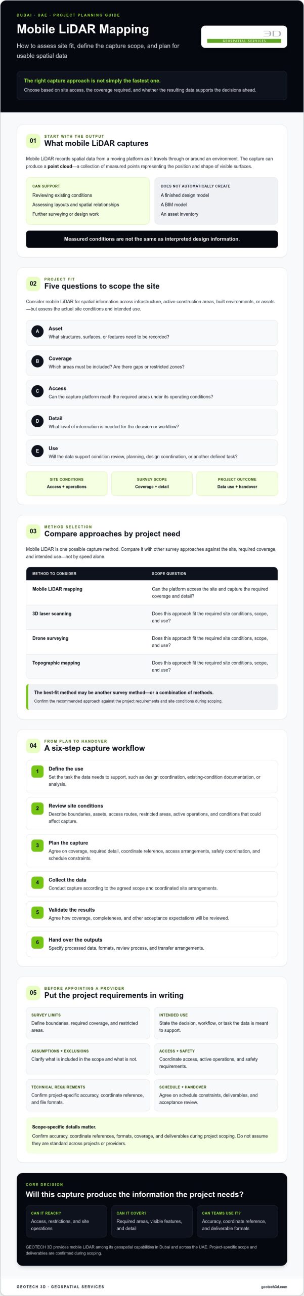
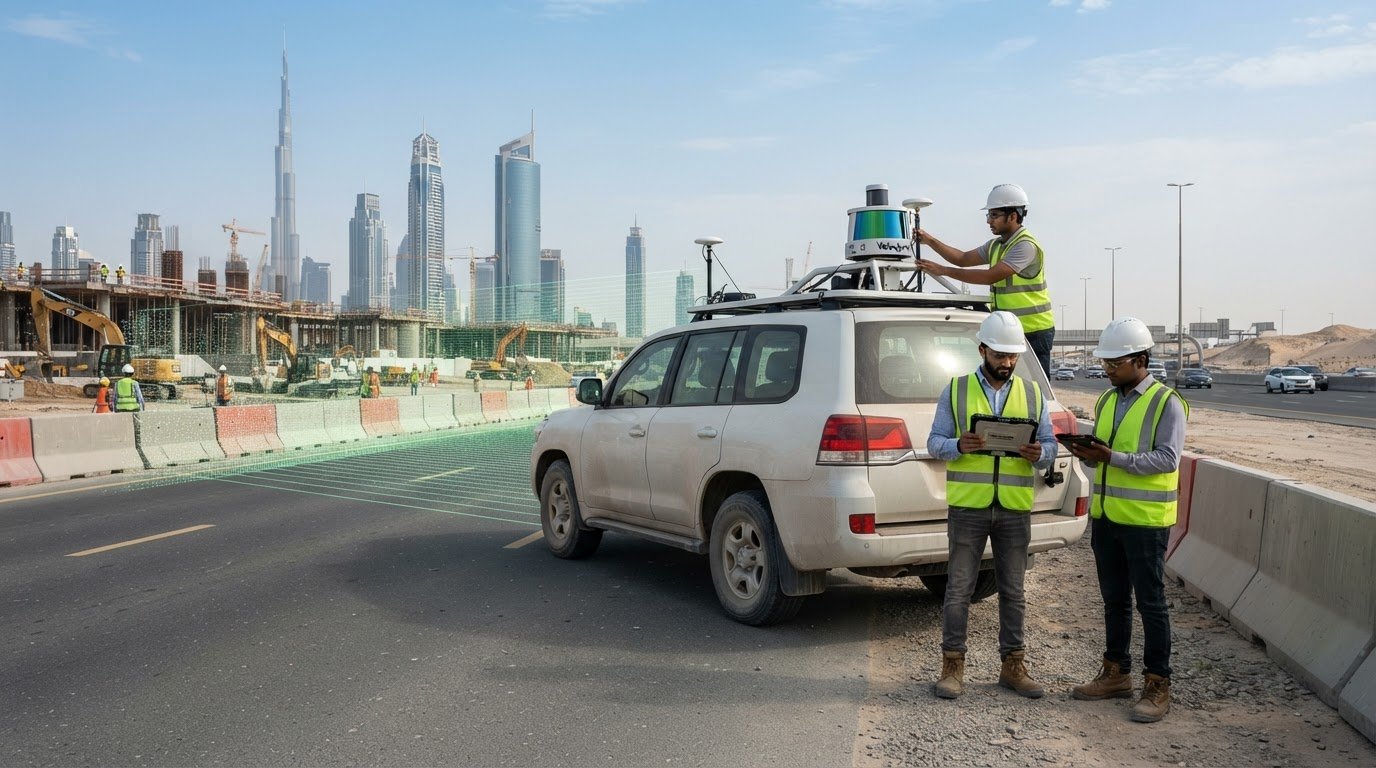
Mobile LiDAR mapping captures spatial data from a moving platform as it travels through or around an environment. The result can include a point cloud, a collection of measured points representing the position and shape of visible surfaces. Depending on the agreed scope, project teams can use this spatial record to review existing conditions, assess layouts, and support further surveying or design work.
Mobile LiDAR mapping is a method of capturing spatial measurements from a moving platform, not a finished design model. A point cloud records measured conditions. It doesn’t automatically interpret them as a design, BIM model, or asset inventory. The broader Mobile mapping overview describes how mobile systems support geospatial data collection and mapping. For a project, the key question is what information the capture can provide and how the team will use it.
What information can a mobile LiDAR survey provide?
Depending on the capture approach, site conditions, and processing scope, point-cloud data may help teams examine spatial relationships, visible features, and surface geometry across a surveyed area. Potential applications include documenting built environments, reviewing infrastructure corridors, or recording existing asset conditions. These are examples, not guaranteed outputs. During scoping, specify the features to be captured, required detail, coverage limits, coordinate reference, and intended handover format. Ask the provider to confirm that its equipment and workflow can meet those requirements.
Which Dubai projects should assess mobile LiDAR?
Consider mobile LiDAR when a team needs spatial information across infrastructure, active construction areas, built environments, or assets, particularly when the capture area is extensive or access needs careful coordination. Suitability depends on more than project type. Check whether the platform can reach the required areas, whether operations can continue safely during capture, and whether the resulting detail supports the planned use.
Before selecting mobile LiDAR mapping Dubai, answer these project-fit questions:
- Asset: What structures, surfaces, or features need to be recorded?
- Coverage: Which areas must be included? Are there gaps or restricted zones?
- Access: Can the capture platform move through the site under its operating conditions?
- Detail: What level of information is needed for the decision or workflow?
- Use: Will the data inform condition review, planning, design coordination, or another task?
Clear answers help a provider assess whether Mobile LiDAR is appropriate or whether another survey method, or a combination of methods, better fits the site. GEOTECH 3D identifies Mobile LiDAR among its geospatial capabilities in Dubai and across the UAE. Confirm project-specific coverage, accuracy, and deliverables during scoping rather than assuming they are standard.
How Mobile LiDAR Mapping Moves from Site Planning to Usable Data
A successful survey starts with the decision the data needs to support, not with equipment selection. Lidar, which stands for Light Detection and Ranging, is a remote measurement approach used to create three-dimensional information. For mobile LiDAR mapping Dubai projects, agree on the capture plan and handover based on the site, required information, and intended workflow.
Project requirements determine the capture plan and data handover. Use this sequence to establish a clear scope:
- Define the use: Identify whether the data will support design coordination, existing-condition documentation, analysis, or another defined task.
- Review site conditions: Describe boundaries, assets, access routes, restricted areas, active operations, and any conditions that could affect capture.
- Plan the capture: Agree on coverage, required detail, coordinate reference, access arrangements, safety coordination, and schedule constraints.
- Collect the data: Conduct capture in line with the agreed scope and coordinated site arrangements.
- Validate the results: Confirm how coverage, completeness, and other agreed acceptance expectations will be reviewed.
- Hand over the outputs: Specify the processed data, formats, review process, and transfer arrangements.
Each step affects the next. A team documenting existing conditions, for example, may need different coverage and outputs from a team preparing spatial data for a design workflow. Confirm technical parameters, coordinate references, file formats, and acceptance criteria for the specific project rather than assuming they are standard.
What should a project brief specify before capture?
Give the provider a clear picture of what needs to be surveyed and why. Include site boundaries, relevant assets, intended use, access conditions, active operations, schedule constraints, and the stakeholders responsible for site coordination and data acceptance. State whether the information is for design, documentation, analysis, or another workflow. Record the required coordinate reference, outputs, and acceptance expectations, then ask the provider to confirm feasibility and scope in writing.
How should data processing and handover be scoped?
Ask what processed data and file formats are available for the agreed capture. Point-cloud data is not automatically a BIM model, GIS dataset, or digital twin. Treat downstream modelling or integration as separate work unless it is expressly included in the scope. Define quality checks, review responsibilities, ownership, transfer method, and what happens if an agreed requirement is not met. These details help make the handover usable, not just complete.
GEOTECH 3D identifies Mobile LiDAR among its geospatial capabilities in Dubai and across the UAE. Share your intended use, site constraints, and required outputs when discussing geospatial services in Dubai, so project-specific capture and handover requirements can be clarified before work is scoped.
Mobile LiDAR vs Other Survey Methods: Choose for the Dubai Site
Survey methods answer different questions. Mobile LiDAR captures spatial data from a moving platform. Terrestrial 3D laser scanning captures measurements from ground-based scanner positions. Drone surveying can collect data from above, while Topographic Mapping focuses on representing terrain and selected site features. As NOAA explains LiDAR technology, LiDAR is a measurement technology. The right survey approach still depends on the project’s purpose and conditions.
Use this comparison as a starting point for provider discussions, not as a substitute for a project-specific scope.
| Method | Typical purpose | Site considerations | Questions to verify |
|---|---|---|---|
| Mobile LiDAR | Spatial capture across areas accessible to a moving platform | Route access, active operations, visibility, and coverage gaps | Which areas and features can be captured, and what outputs are included? |
| Terrestrial 3D laser scanning | Capturing the geometry of buildings, spaces, or assets from ground positions | Scanner access, setup locations, obstructions, and required detail | Are additional positions or complementary capture needed? |
| Drone surveying | Aerial data collection where the site and project needs suit an overhead approach | Airspace, permissions where applicable, safe operations, and visual access | Is drone capture suitable for this site, and what data products are in scope? |
| Topographic Mapping | Documenting terrain and specified site features for planning or design | Survey limits, surface conditions, control requirements, and feature list | Which features, coordinate reference, and drawing or data outputs are required? |
When should teams compare mobile and terrestrial LiDAR?
Compare mobility, access, asset geometry, required detail, and the area to be surveyed. A route-based capture may suit some coverage needs, while individual assets or complex spaces may call for ground-based scanning positions. Site constraints can also make a combined approach appropriate. Ask the provider to identify blind spots, method limitations, and any complementary capture needed to meet the scope.
When are drone surveying or GPR more relevant?
Drone surveying may be worth assessing when the required data and site conditions suit aerial collection. It isn’t a default replacement for ground capture. Underground assets require a different scope: Utility Mapping (GPR) addresses subsurface mapping needs, which above-ground LiDAR capture doesn’t establish. For more on that distinction, see this Dubai utility mapping guide.
Likewise, a point cloud isn’t automatically a BIM model. If the project needs BIM development from scan data, clarify that downstream scope separately and consult the Scan-to-BIM guide. The most suitable mobile LiDAR mapping Dubai approach is the one that matches the site, required information, and agreed handover.
How to Evaluate a Mobile LiDAR Mapping Provider in Dubai
A strong proposal explains how the survey will meet your project requirements, not just which equipment or technology category will be used. For mobile LiDAR mapping Dubai, assess the provider’s relevant experience, proposed capture approach, site safety planning, and ability to work within your schedule. Ask for a written scope that states survey limits, intended use, assumptions, exclusions, and handover requirements.
Compare proposals on project fit and data usability. Equipment labels alone won’t tell you whether the proposed method can access the required areas or provide information suited to your workflow. Look for clear communication about limitations, coordination needs, and what the provider has and hasn’t included.
What questions should a Dubai project team ask providers?
Ask how the proposed method addresses your site conditions, access, coverage, and intended use. Request written confirmation of the capture capabilities, deliverables, coordinate references, and quality checks proposed for your project. Clarify who coordinates with site stakeholders, how safety responsibilities are allocated, and which assumptions affect the schedule. Make exclusions explicit, especially where restricted access or active operations may affect coverage.
- What areas and assets are within the survey limits?
- What access or operational constraints could affect capture?
- Which outputs and coordinate references are included?
- What review and acceptance steps are proposed?
- Which schedule assumptions depend on site readiness or stakeholder coordination?
How can buyers assess data quality without unsupported promises?
Ask the provider to define quality requirements for the actual workflow, then explain how they’ll be documented and checked. Where relevant, clarify how completeness, registration, and acceptance will be assessed, and what evidence will be provided at handover. Treat accuracy figures as project-specific. Don’t rely on generic claims unless the provider confirms the figure, measurement basis, and applicability to the proposed capture and processing approach.
A useful proposal makes it possible to compare scope, limitations, coordination, and outputs on consistent terms. Discuss the site, intended use, and required handover to clarify whether the proposed scope is a fit.
Commission Mobile LiDAR Mapping in Dubai with GEOTECH 3D
GEOTECH 3D provides Mobile LiDAR as part of its geospatial services in Dubai and across the UAE. Whether it fits your project depends on the site, the information required, and how the data will be used. Share those details early so the proposed scope can address access, coordination, schedule, and project-specific outputs without relying on assumptions about standard equipment or deliverables.
What project information helps GEOTECH 3D assess fit?
Prepare a concise project brief with the location, survey purpose, approximate area or limits, and the assets or features of interest. Include site access conditions, active operations, key stakeholders, safety requirements, and target schedule. These details help establish whether the proposed capture approach is practical for the site and what coordination may be needed.
Also identify the intended downstream use. If the data needs to support GIS, design coordination, asset documentation, or another workflow, specify that purpose along with any required file formats and coordinate references. GEOTECH 3D’s GIS & Surveying Services may be relevant where the agreed scope calls for a broader surveying or spatial-data workflow. Confirm any such work and its deliverables explicitly rather than assuming they are included with Mobile LiDAR.
How can mapped data support later project workflows?
Spatial data may contribute to GIS analysis, BIM development, asset management, or digital-twin workflows, but capture alone doesn’t automatically include modelling, integration, or ongoing data management. Define what the project needs beyond the survey and confirm the responsibilities, outputs, and handover for each stage.
For projects involving city modelling, smart-city management, or spatial analysis, GEOTECH 3D’s Geoverse Platform may be relevant for discussion. Its suitability depends on the project objectives and agreed scope. Teams considering a wider digital-twin lifecycle can review this digital twin lifecycle guide as they define how captured information may fit into subsequent workflows.
A well-prepared brief gives the project team and provider a shared basis for discussing mobile LiDAR mapping Dubai requirements. Bring together the site information, objectives, access constraints, schedule, and expected outputs, then confirm technical parameters and deliverables before commissioning. GEOTECH 3D can discuss how its Mobile LiDAR capability may fit your project requirements.
Make Your Next Mapping Decision with Confidence
The right survey method is the one that matches the site and the decisions your team needs to make. For mobile LiDAR mapping Dubai projects, define the intended use first, then confirm access, required coverage, technical parameters, and handover requirements with the provider. A clear written scope helps teams assess project fit and compare proposals based on usable outputs, not equipment labels alone.
GEOTECH 3D lists Mobile LiDAR among its geospatial capabilities in Dubai and across the UAE. Its company information highlights accurate data collection, safety compliance, and schedule requirements. Discuss your project objectives and constraints directly, and confirm the specific capture approach and deliverables during scoping.
With a shared understanding of the site, scope, and expected data, your team can take the next step with greater clarity and confidence.
Frequently Asked Questions
What is mobile LiDAR mapping, and what data does it capture?
Mobile LiDAR mapping records spatial measurements from a moving platform and can produce a three-dimensional point cloud of visible surfaces. Teams may use that data to examine existing conditions, spatial relationships, and captured features. It isn’t a finished design model or a complete asset register by default. The surveyed area, visible features, processing, and handover depend on the project scope and must be confirmed with the provider.
Is mobile LiDAR mapping suitable for construction projects in Dubai?
It may suit a construction project when the required coverage, site access, operational conditions, and intended use align with the provider’s confirmed capture capabilities. For mobile LiDAR mapping Dubai projects, assess whether the platform can access relevant areas while site activities are coordinated safely. Define what information the team needs, such as existing-condition context or spatial records, then ask the provider to confirm method suitability, limitations, and deliverables.
How does mobile LiDAR mapping differ from drone surveying or 3D laser scanning?
Mobile LiDAR captures spatial data from a moving platform, drone surveying collects data from an aerial perspective, and terrestrial 3D laser scanning captures from ground-based scanner positions. Each approach has different access and coverage considerations. The suitable method depends on the asset, site conditions, required detail, and intended use. Providers can explain whether one method is sufficient or whether complementary capture is needed to address coverage gaps.
Can mobile LiDAR mapping detect underground utilities?
No, above-ground mobile LiDAR capture shouldn’t be treated as underground utility detection. Subsurface assets require a separate method and scope. GEOTECH 3D lists Utility Mapping (GPR) among its services for subsurface mapping requirements. If underground infrastructure is relevant, state that clearly in the project brief and ask how the utility-mapping scope, outputs, and coordination relate to any above-ground survey work.
What deliverables should I request from a mobile LiDAR mapping provider?
Request deliverables that match your project workflow, and have the provider confirm what it can supply for the proposed scope. Clarify whether the handover includes processed point-cloud data, the required coordinate reference and file formats, surveyed limits, and documentation of agreed quality checks. If you need BIM, GIS, or another downstream output, specify it separately. Capture data alone doesn’t automatically include modelling or integration.
How do I compare mobile LiDAR mapping providers in Dubai?
Compare providers by how clearly they address your site and intended use, not by equipment names or broad accuracy claims alone. Review relevant experience, the proposed capture method, access and safety planning, schedule assumptions, limitations, and written handover scope. Ask how project-specific quality requirements will be checked and documented. A useful proposal makes inclusions, exclusions, coordination responsibilities, and deliverable acceptance clear enough to assess consistently.
What information should I provide when requesting a mobile LiDAR survey?
Provide the site location and boundaries, survey purpose, assets or features of interest, and an approximate description of the scope. Include access conditions, active site operations, relevant stakeholders, safety requirements, and target schedule. Identify the intended use of the data and any required file formats or coordinate references. These details help the provider assess fit and confirm the capture approach, technical requirements, and deliverables before work is commissioned.
The best capture approach isn’t automatically the one that covers the most ground fastest. For mobile LiDAR mapping Dubai projects, the right choice depends on whether the method can access your site, record the coverage you need, and produce data suited to the decisions ahead. This matters when work must fit around active operations, access restrictions, and safety requirements.
If you’re unsure whether mobile LiDAR suits your site or how to compare providers offering different methods and deliverables, start with the project requirements. The technology can support spatial data collection, but its suitability depends on the environment, scope, and intended use of the output.
This guide explains how mobile LiDAR mapping works and how to assess its fit for a Dubai project. You’ll learn what to clarify about capture approach, coverage, coordinate reference, accuracy, file formats, site access, safety coordination, and schedule before appointing a provider. GEOTECH 3D provides mobile LiDAR among its geospatial capabilities in Dubai and across the UAE. Confirm project-specific deliverables during scoping.
Key Takeaways
- Match the capture method to site conditions, required coverage, and the decisions the data must support.
- Understand how mobile LiDAR turns spatial capture into a point cloud that project teams can use for planning and assessment.
- Compare mobile LiDAR mapping Dubai with 3D laser scanning, drone surveying, and Topographic Mapping based on project needs.
- Before appointing a provider, define survey limits, intended use, assumptions, exclusions, safety coordination, and handover requirements in writing.
- Confirm project-specific accuracy, coordinate references, formats, and deliverables during scoping, including when connecting Mobile LiDAR to other surveying or GIS work.
What Mobile LiDAR Mapping in Dubai Captures and When Projects Need It
Mobile LiDAR mapping captures spatial data from a moving platform as it travels through or around an environment. The result can include a point cloud, a collection of measured points representing the position and shape of visible surfaces. Depending on the agreed scope, project teams can use this spatial record to review existing conditions, assess layouts, and support further surveying or design work.
Mobile LiDAR mapping is a method of capturing spatial measurements from a moving platform, not a finished design model. A point cloud records measured conditions. It doesn’t automatically interpret them as a design, BIM model, or asset inventory. The broader Mobile mapping overview describes how mobile systems support geospatial data collection and mapping. For a project, the key question is what information the capture can provide and how the team will use it.
What information can a mobile LiDAR survey provide?
Depending on the capture approach, site conditions, and processing scope, point-cloud data may help teams examine spatial relationships, visible features, and surface geometry across a surveyed area. Potential applications include documenting built environments, reviewing infrastructure corridors, or recording existing asset conditions. These are examples, not guaranteed outputs. During scoping, specify the features to be captured, required detail, coverage limits, coordinate reference, and intended handover format. Ask the provider to confirm that its equipment and workflow can meet those requirements.
Which Dubai projects should assess mobile LiDAR?
Consider mobile LiDAR when a team needs spatial information across infrastructure, active construction areas, built environments, or assets, particularly when the capture area is extensive or access needs careful coordination. Suitability depends on more than project type. Check whether the platform can reach the required areas, whether operations can continue safely during capture, and whether the resulting detail supports the planned use.
Before selecting mobile LiDAR mapping Dubai, answer these project-fit questions:
- Asset: What structures, surfaces, or features need to be recorded?
- Coverage: Which areas must be included? Are there gaps or restricted zones?
- Access: Can the capture platform move through the site under its operating conditions?
- Detail: What level of information is needed for the decision or workflow?
- Use: Will the data inform condition review, planning, design coordination, or another task?
Clear answers help a provider assess whether Mobile LiDAR is appropriate or whether another survey method, or a combination of methods, better fits the site. GEOTECH 3D identifies Mobile LiDAR among its geospatial capabilities in Dubai and across the UAE. Confirm project-specific coverage, accuracy, and deliverables during scoping rather than assuming they are standard.
How Mobile LiDAR Mapping Moves from Site Planning to Usable Data
A successful survey starts with the decision the data needs to support, not with equipment selection. Lidar, which stands for Light Detection and Ranging, is a remote measurement approach used to create three-dimensional information. For mobile LiDAR mapping Dubai projects, agree on the capture plan and handover based on the site, required information, and intended workflow.
Project requirements determine the capture plan and data handover. Use this sequence to establish a clear scope:
- Define the use: Identify whether the data will support design coordination, existing-condition documentation, analysis, or another defined task.
- Review site conditions: Describe boundaries, assets, access routes, restricted areas, active operations, and any conditions that could affect capture.
- Plan the capture: Agree on coverage, required detail, coordinate reference, access arrangements, safety coordination, and schedule constraints.
- Collect the data: Conduct capture in line with the agreed scope and coordinated site arrangements.
- Validate the results: Confirm how coverage, completeness, and other agreed acceptance expectations will be reviewed.
- Hand over the outputs: Specify the processed data, formats, review process, and transfer arrangements.
Each step affects the next. A team documenting existing conditions, for example, may need different coverage and outputs from a team preparing spatial data for a design workflow. Confirm technical parameters, coordinate references, file formats, and acceptance criteria for the specific project rather than assuming they are standard.
What should a project brief specify before capture?
Give the provider a clear picture of what needs to be surveyed and why. Include site boundaries, relevant assets, intended use, access conditions, active operations, schedule constraints, and the stakeholders responsible for site coordination and data acceptance. State whether the information is for design, documentation, analysis, or another workflow. Record the required coordinate reference, outputs, and acceptance expectations, then ask the provider to confirm feasibility and scope in writing.
How should data processing and handover be scoped?
Ask what processed data and file formats are available for the agreed capture. Point-cloud data is not automatically a BIM model, GIS dataset, or digital twin. Treat downstream modelling or integration as separate work unless it is expressly included in the scope. Define quality checks, review responsibilities, ownership, transfer method, and what happens if an agreed requirement is not met. These details help make the handover usable, not just complete.
GEOTECH 3D identifies Mobile LiDAR among its geospatial capabilities in Dubai and across the UAE. Share your intended use, site constraints, and required outputs when discussing geospatial services in Dubai, so project-specific capture and handover requirements can be clarified before work is scoped.
Mobile LiDAR vs Other Survey Methods: Choose for the Dubai Site
Survey methods answer different questions. Mobile LiDAR captures spatial data from a moving platform. Terrestrial 3D laser scanning captures measurements from ground-based scanner positions. Drone surveying can collect data from above, while Topographic Mapping focuses on representing terrain and selected site features. As NOAA explains LiDAR technology, LiDAR is a measurement technology. The right survey approach still depends on the project’s purpose and conditions.
Use this comparison as a starting point for provider discussions, not as a substitute for a project-specific scope.
| Method | Typical purpose | Site considerations | Questions to verify |
|---|---|---|---|
| Mobile LiDAR | Spatial capture across areas accessible to a moving platform | Route access, active operations, visibility, and coverage gaps | Which areas and features can be captured, and what outputs are included? |
| Terrestrial 3D laser scanning | Capturing the geometry of buildings, spaces, or assets from ground positions | Scanner access, setup locations, obstructions, and required detail | Are additional positions or complementary capture needed? |
| Drone surveying | Aerial data collection where the site and project needs suit an overhead approach | Airspace, permissions where applicable, safe operations, and visual access | Is drone capture suitable for this site, and what data products are in scope? |
| Topographic Mapping | Documenting terrain and specified site features for planning or design | Survey limits, surface conditions, control requirements, and feature list | Which features, coordinate reference, and drawing or data outputs are required? |
When should teams compare mobile and terrestrial LiDAR?
Compare mobility, access, asset geometry, required detail, and the area to be surveyed. A route-based capture may suit some coverage needs, while individual assets or complex spaces may call for ground-based scanning positions. Site constraints can also make a combined approach appropriate. Ask the provider to identify blind spots, method limitations, and any complementary capture needed to meet the scope.
When are drone surveying or GPR more relevant?
Drone surveying may be worth assessing when the required data and site conditions suit aerial collection. It isn’t a default replacement for ground capture. Underground assets require a different scope: Utility Mapping (GPR) addresses subsurface mapping needs, which above-ground LiDAR capture doesn’t establish. For more on that distinction, see this Dubai utility mapping guide.
Likewise, a point cloud isn’t automatically a BIM model. If the project needs BIM development from scan data, clarify that downstream scope separately and consult the Scan-to-BIM guide. The most suitable mobile LiDAR mapping Dubai approach is the one that matches the site, required information, and agreed handover.
How to Evaluate a Mobile LiDAR Mapping Provider in Dubai
A strong proposal explains how the survey will meet your project requirements, not just which equipment or technology category will be used. For mobile LiDAR mapping Dubai, assess the provider’s relevant experience, proposed capture approach, site safety planning, and ability to work within your schedule. Ask for a written scope that states survey limits, intended use, assumptions, exclusions, and handover requirements.
Compare proposals on project fit and data usability. Equipment labels alone won’t tell you whether the proposed method can access the required areas or provide information suited to your workflow. Look for clear communication about limitations, coordination needs, and what the provider has and hasn’t included.
What questions should a Dubai project team ask providers?
Ask how the proposed method addresses your site conditions, access, coverage, and intended use. Request written confirmation of the capture capabilities, deliverables, coordinate references, and quality checks proposed for your project. Clarify who coordinates with site stakeholders, how safety responsibilities are allocated, and which assumptions affect the schedule. Make exclusions explicit, especially where restricted access or active operations may affect coverage.
- What areas and assets are within the survey limits?
- What access or operational constraints could affect capture?
- Which outputs and coordinate references are included?
- What review and acceptance steps are proposed?
- Which schedule assumptions depend on site readiness or stakeholder coordination?
How can buyers assess data quality without unsupported promises?
Ask the provider to define quality requirements for the actual workflow, then explain how they’ll be documented and checked. Where relevant, clarify how completeness, registration, and acceptance will be assessed, and what evidence will be provided at handover. Treat accuracy figures as project-specific. Don’t rely on generic claims unless the provider confirms the figure, measurement basis, and applicability to the proposed capture and processing approach.
A useful proposal makes it possible to compare scope, limitations, coordination, and outputs on consistent terms. Discuss the site, intended use, and required handover to clarify whether the proposed scope is a fit.
Commission Mobile LiDAR Mapping in Dubai with GEOTECH 3D
GEOTECH 3D provides Mobile LiDAR as part of its geospatial services in Dubai and across the UAE. Whether it fits your project depends on the site, the information required, and how the data will be used. Share those details early so the proposed scope can address access, coordination, schedule, and project-specific outputs without relying on assumptions about standard equipment or deliverables.
What project information helps GEOTECH 3D assess fit?
Prepare a concise project brief with the location, survey purpose, approximate area or limits, and the assets or features of interest. Include site access conditions, active operations, key stakeholders, safety requirements, and target schedule. These details help establish whether the proposed capture approach is practical for the site and what coordination may be needed.
Also identify the intended downstream use. If the data needs to support GIS, design coordination, asset documentation, or another workflow, specify that purpose along with any required file formats and coordinate references. GEOTECH 3D’s GIS & Surveying Services may be relevant where the agreed scope calls for a broader surveying or spatial-data workflow. Confirm any such work and its deliverables explicitly rather than assuming they are included with Mobile LiDAR.
How can mapped data support later project workflows?
Spatial data may contribute to GIS analysis, BIM development, asset management, or digital-twin workflows, but capture alone doesn’t automatically include modelling, integration, or ongoing data management. Define what the project needs beyond the survey and confirm the responsibilities, outputs, and handover for each stage.
For projects involving city modelling, smart-city management, or spatial analysis, GEOTECH 3D’s Geoverse Platform may be relevant for discussion. Its suitability depends on the project objectives and agreed scope. Teams considering a wider digital-twin lifecycle can review this digital twin lifecycle guide as they define how captured information may fit into subsequent workflows.
A well-prepared brief gives the project team and provider a shared basis for discussing mobile LiDAR mapping Dubai requirements. Bring together the site information, objectives, access constraints, schedule, and expected outputs, then confirm technical parameters and deliverables before commissioning. GEOTECH 3D can discuss how its Mobile LiDAR capability may fit your project requirements.
Make Your Next Mapping Decision with Confidence
The right survey method is the one that matches the site and the decisions your team needs to make. For mobile LiDAR mapping Dubai projects, define the intended use first, then confirm access, required coverage, technical parameters, and handover requirements with the provider. A clear written scope helps teams assess project fit and compare proposals based on usable outputs, not equipment labels alone.
GEOTECH 3D lists Mobile LiDAR among its geospatial capabilities in Dubai and across the UAE. Its company information highlights accurate data collection, safety compliance, and schedule requirements. Discuss your project objectives and constraints directly, and confirm the specific capture approach and deliverables during scoping.
With a shared understanding of the site, scope, and expected data, your team can take the next step with greater clarity and confidence.
Frequently Asked Questions
What is mobile LiDAR mapping, and what data does it capture?
Mobile LiDAR mapping records spatial measurements from a moving platform and can produce a three-dimensional point cloud of visible surfaces. Teams may use that data to examine existing conditions, spatial relationships, and captured features. It isn’t a finished design model or a complete asset register by default. The surveyed area, visible features, processing, and handover depend on the project scope and must be confirmed with the provider.
Is mobile LiDAR mapping suitable for construction projects in Dubai?
It may suit a construction project when the required coverage, site access, operational conditions, and intended use align with the provider’s confirmed capture capabilities. For mobile LiDAR mapping Dubai projects, assess whether the platform can access relevant areas while site activities are coordinated safely. Define what information the team needs, such as existing-condition context or spatial records, then ask the provider to confirm method suitability, limitations, and deliverables.
How does mobile LiDAR mapping differ from drone surveying or 3D laser scanning?
Mobile LiDAR captures spatial data from a moving platform, drone surveying collects data from an aerial perspective, and terrestrial 3D laser scanning captures from ground-based scanner positions. Each approach has different access and coverage considerations. The suitable method depends on the asset, site conditions, required detail, and intended use. Providers can explain whether one method is sufficient or whether complementary capture is needed to address coverage gaps.
Can mobile LiDAR mapping detect underground utilities?
No, above-ground mobile LiDAR capture shouldn’t be treated as underground utility detection. Subsurface assets require a separate method and scope. GEOTECH 3D lists Utility Mapping (GPR) among its services for subsurface mapping requirements. If underground infrastructure is relevant, state that clearly in the project brief and ask how the utility-mapping scope, outputs, and coordination relate to any above-ground survey work.
What deliverables should I request from a mobile LiDAR mapping provider?
Request deliverables that match your project workflow, and have the provider confirm what it can supply for the proposed scope. Clarify whether the handover includes processed point-cloud data, the required coordinate reference and file formats, surveyed limits, and documentation of agreed quality checks. If you need BIM, GIS, or another downstream output, specify it separately. Capture data alone doesn’t automatically include modelling or integration.
How do I compare mobile LiDAR mapping providers in Dubai?
Compare providers by how clearly they address your site and intended use, not by equipment names or broad accuracy claims alone. Review relevant experience, the proposed capture method, access and safety planning, schedule assumptions, limitations, and written handover scope. Ask how project-specific quality requirements will be checked and documented. A useful proposal makes inclusions, exclusions, coordination responsibilities, and deliverable acceptance clear enough to assess consistently.
What information should I provide when requesting a mobile LiDAR survey?
Provide the site location and boundaries, survey purpose, assets or features of interest, and an approximate description of the scope. Include access conditions, active site operations, relevant stakeholders, safety requirements, and target schedule. Identify the intended use of the data and any required file formats or coordinate references. These details help the provider assess fit and confirm the capture approach, technical requirements, and deliverables before work is commissioned.
Search Now
Error: Contact form not found.