

Our Services
Precision Mapping for UAE Oil and Gas Assets
What if a survey captures detailed data but does not answer the project team’s actual question? Precision mapping for oil and gas starts by matching the capture method and deliverable to the asset and the decisions the information needs to support. In Dubai and across the UAE, that means defining the site context, operational constraints, safety requirements, and how teams will use the data after collection.
Facilities, brownfields, and pipeline environments can call for different forms of capture, while project teams may need separate datasets to work together. This guide explains how laser scanning, drone surveys, and GIS support oil and gas applications, and what to define before fieldwork. GEOTECH 3D provides 3D Scanning Oil & Gas and Oil & Gas Surveys, connecting site capture with practical deliverables, from point-cloud data to BIM-ready models compatible with client CAD packages. Use the guidance below to plan coordinated fieldwork and specify asset records that suit the project’s needs.
Key Takeaways
- Precision mapping for oil and gas begins by defining the asset and the decision the spatial data needs to support.
- Laser scanning, drone surveys, and GIS serve different roles. Match each method to the site and the required output.
- Before fieldwork, define the project boundary, access arrangements, operating constraints, intended use, and coordination needs.
- Specify how captured data should be organized and reviewed so project teams can use it downstream.
- GEOTECH 3D provides oil and gas scanning, drone surveys, and GIS capabilities, with a path from point clouds to BIM-ready models compatible with client CAD packages.
Why precision mapping matters for oil and gas assets
Precision mapping for oil and gas is the collection and organization of spatial information for a defined asset or project purpose. It turns site observations into a structured record that teams can use to understand the locations and relationships of relevant features. The right content and format depend on the decisions the information must support.
An existing drawing may be useful for design or reference, but it may not reflect current site conditions. A generalized basemap provides geographic context, not necessarily a detailed record of a particular facility or asset. A mapped record is based on survey data collected for an agreed scope. Its usefulness depends on a clear description of what was surveyed, how the data is organized, and what the deliverable represents. Mapping does not make existing drawings accurate; it gives project teams a basis for reviewing spatial information against the survey scope.
Where oil and gas teams use mapped asset information
Oil and gas facilities and brownfields can include existing structures and site features that teams need to understand in relation to planned work. A mapped view gives the project team a shared spatial reference for discussing those conditions. GEOTECH 3D uses laser scanning to create accurate 3D models of facilities and brownfields. Its oil and gas surveying work also covers pipelines, power plants, and chemical industry projects.
For a pipeline project, spatially organized survey information can help teams consider a route in relation to surrounding site conditions. At a power plant, a mapped record can provide context for planning work around existing assets. These are examples of possible applications, not descriptions of specific GEOTECH 3D projects. Define the survey scope around the asset and the questions the project team needs to answer.
Spatial records also serve a different purpose from geological mapping. A Geological map represents geological features such as rock units and structures. It can provide broader context, but it is not a substitute for a site-specific survey of visible assets and conditions.
What makes mapping useful for project decisions
Useful mapping helps teams coordinate around a consistent understanding of site conditions. Designers can consider surveyed context, project managers can plan work around known assets, and asset owners can review information in relation to the facilities or infrastructure they manage. The value comes from answering a project question, not simply collecting more data.
Start by stating what the record must help the team decide. Is the goal to understand a facility, plan work near existing infrastructure, or create a spatial reference for coordination? The answer guides both the survey scope and the deliverable. A detailed model that does not address the intended use may be less practical than a focused dataset organized for the task.
In Dubai and across the UAE, aligning mapped information with project needs helps teams use survey records more effectively in planning and coordination. Treat the record as information about the agreed survey scope, not as a guarantee of future site conditions.
How precision mapping combines laser scanning, drone surveys, and GIS
Precision mapping for oil and gas can draw on several methods, each suited to a different part of data collection and management. Laser scanning captures spatial data for three-dimensional representation. Drone surveys provide an aerial perspective and can support visual and thermal inspection. GIS organizes spatial information so teams can view and use it in context. These methods can complement one another, but they are not interchangeable. Choose the combination according to the asset, site conditions, and intended deliverable.
What 3D Scanning Oil & Gas contributes
GEOTECH 3D’s 3D Scanning Oil & Gas service uses laser scanning to produce accurate 3D models of oil and gas facilities and brownfields. The point cloud records surveyed surfaces as spatial data and can provide the basis for a model that helps teams interpret existing conditions in three dimensions.
When the project requires a BIM-ready output, GEOTECH 3D can develop point-cloud data into models compatible with client CAD packages. Set the intended model content and level of detail according to how the team will use it. That keeps the deliverable focused on the work rather than adding unnecessary complexity. The Scan to BIM guide explores the point-cloud-to-model workflow in more detail.
When drone surveys and GIS support the mapping scope
Drone-based Oil & Gas Surveys provide another way to collect site information, particularly when aerial coverage or inspection is part of the project need. GEOTECH 3D provides integrated thermal and visual drone inspections that can detect anomalies, cold spots, and internal damages without ground personnel. The DJI Zenmuse H20T is a multi-sensor payload used for fast, accurate data collection.
GIS has a different role. It organizes spatial information into a framework that teams can view and use across project contexts, rather than acting as a field capture method on its own. For example, data from separate assets or work areas can be managed in relation to location and shared project context. The structure should reflect what teams need to understand or coordinate.
Using several methods can connect detailed facility information, aerial survey data, and organized spatial records. The goal is not to use every technology on every site. Instead, align data collection and processing with the asset and the decisions the deliverables must support. GEOTECH 3D’s oil and gas mapping capabilities bring laser scanning, drone surveys, and GIS into a project-specific approach.
Choosing an oil and gas mapping approach for the asset and decision
The right mapping method answers the project question with a suitable deliverable. A facility model, an aerial survey record, and a GIS dataset have different purposes. For precision mapping for oil and gas, define the asset, site conditions, and intended use before deciding whether to use one method or combine several.
| Method | Suitable project context | Intended information output |
|---|---|---|
| Laser scanning | Facilities and brownfields where teams need a detailed three-dimensional representation of surveyed conditions | Point-cloud data and, where required, a 3D model; BIM-ready models can be compatible with client CAD packages |
| Drone surveys | Aerial survey or inspection contexts associated with oil and gas assets, subject to project scope and site conditions | Drone-based survey information or, for integrated thermal and visual inspections, imagery that can help detect anomalies, cold spots, and internal damages |
| GIS | Projects that need spatial information organized for viewing, analysis, or use across asset and work-area contexts | A structured spatial record that helps teams interpret information in its geographic context |
Match the method to the asset and site context
Laser scanning is used to produce accurate 3D models of facilities and brownfields. It is suited to work that depends on understanding the surveyed asset in three dimensions. Drone surveys serve a different role when aerial survey information or visual and thermal inspection is relevant. GIS organizes spatial records rather than replacing field capture. Select methods based on the agreed scope and conditions at the site.
These distinctions help frame work at pipelines, power plants, and chemical industry sites. The asset type alone does not determine the method. A pipeline assignment may call for survey information organized around a project area, while a facility-based question may need a 3D representation. Let the site conditions and required output guide the approach.
Match deliverables to the next project decision
Start with what the team needs to do with the information. Is the requirement a spatial record for reference, a 3D model to understand existing conditions, survey information for a defined scope, or organized data for analysis? A specific answer keeps capture requirements and deliverable expectations aligned.
Point-cloud data, for example, can support the development of BIM-ready models compatible with client CAD packages. If the decision depends on organizing information across work areas, GIS may be central to the deliverable. Drone survey or inspection information addresses a different need. Combining datasets can help when separate questions require distinct outputs, but the scope should state how each dataset will be used. Do not assume methods or outputs are integrated unless the project requirements include that work.
For assets in Dubai and across the UAE, a method comparison is a starting point, not a fixed prescription. Define the decision, identify site constraints, and specify the outputs. GEOTECH 3D scopes oil and gas mapping around those project needs.
How to plan a precise, safety-focused oil and gas mapping project in the UAE
A clear plan connects the project question to field capture and a usable deliverable. For precision mapping for oil and gas, the asset boundary, operating context, access arrangements, and intended use all shape the survey scope. Addressing these points early helps align fieldwork with site priorities and supports coordination in Dubai and across the UAE.
Define scope before field data collection
Identify the assets to be surveyed and the limits of the work area. Then state the question the mapping must help answer. A facility model, survey information for a pipeline area, and a spatial record for project coordination may call for different capture approaches and outputs.
Before fieldwork, agree on:
- The assets, site boundary, and areas included in the survey.
- The intended use of the mapped information and the teams who will rely on it.
- Access arrangements, relevant operating constraints, and possible fieldwork windows.
- The required deliverables, review approach, and project-specific accuracy expectations.
- Coordination points between the survey team and the site team.
These details make the scope actionable. If a model will inform later design coordination, for example, define the expected model content and how it should relate to the client’s CAD environment. Make accuracy requirements and schedule expectations specific to the asset and task rather than assuming one standard applies to every site.
Coordinate safe capture and review
Operational sites require deliberate field planning. Include safety requirements and site coordination alongside access conditions and the agreed work area. GEOTECH 3D emphasizes strict safety compliance, accurate data collection, and working to tight schedules. Planning should account for those priorities without assuming that every survey can avoid personnel involvement or operational disruption.
A practical project sequence is:
- Confirm the project question, asset boundary, and intended use.
- Discuss site access, operating constraints, schedule expectations, and coordination arrangements.
- Agree on the capture method and define the expected data and deliverables.
- Coordinate field activities with the relevant site team and carry out capture within the agreed scope.
- Review the collected information against the project purpose and agreed deliverable requirements.
Review the deliverable against the defined need: check whether it represents the required areas and whether the output is organized for its next use. If the review identifies a gap against the agreed scope, address it as a project coordination item rather than leaving it to emerge during downstream work.
For oil and gas mapping in the UAE, a clear brief connects site conditions, safety planning, field capture, and usable project information.
From oil and gas field data to usable asset records with GEOTECH 3D
Field data is more useful when its format and organization reflect how project teams will work with it. GEOTECH 3D provides laser-scanning, drone-survey, and GIS capabilities for oil and gas mapping, with the scope shaped around the asset and intended outputs. This gives teams a basis for defining what information to collect and how to present it for review in Dubai and across the UAE.
What GEOTECH 3D brings to oil and gas mapping
3D Scanning Oil & Gas uses laser-scanning technology to develop 3D models of facilities and brownfields. Oil & Gas Surveys and drone-based surveys support other project information needs, while GIS organizes spatial data for use in context. These services apply to work involving facilities, brownfields, pipelines, power plants, and chemical industry sites.
For projects requiring a model-based output, GEOTECH 3D can take raw point-cloud data through to BIM-ready models compatible with client CAD packages. Define the intended users and downstream workflow to clarify which information the asset record should show and how teams will review it.
Define the next step for a UAE project
A productive scope discussion starts with the asset and the work ahead. Set out the site context, project purpose, and expected use of the deliverables. Teams may need a record to support facility documentation, planning, or coordination across a defined asset area. Clarifying priorities connects the required information to a suitable output.
Consider how the resulting record will be used after delivery. Identify the teams that need it, the project activities it should support, and how it should fit alongside existing asset information. Clear expectations help keep the deliverable relevant beyond the immediate capture task.
GEOTECH 3D scopes oil and gas mapping around the asset, required data, and intended outputs. Use the project context to define a focused mapping scope.
Turn your next asset question into a clear mapping brief
Use precision mapping for oil and gas to support decisions, not simply as a one-time data collection exercise. Before the next project phase, identify who will use the spatial information, what they need to resolve, and whether the record should support work beyond the immediate task. Making these expectations explicit keeps the brief focused and the deliverables relevant.
Bring together the people who will define the site scope and use the outputs. Align on the asset area, project purpose, key operating constraints, and how teams need to review the information. This shared brief gives the mapping work direction while allowing capture and deliverables to be tailored to the project.
GEOTECH 3D works with oil and gas teams in Dubai and across the UAE to scope mapping around asset needs, safe coordination, and usable data. Start with the decisions your project needs to support.
A clear brief is the first step toward planning around relevant project information. Begin with the asset question your team needs to answer.
Frequently Asked Questions
What is precision mapping for oil and gas?
It is a spatial record tailored to a defined oil and gas task. The project team determines which asset features need to be represented and how the information will be used. For example, a team preparing a modification may need existing equipment and structures shown in context for review. GEOTECH 3D supports oil and gas mapping with laser scanning, drone surveys, and GIS, scoped to project requirements.
How accurate is oil and gas mapping?
Accuracy requirements depend on the project, so no single figure applies to every survey. Review whether the required areas and features are represented and whether the information meets the agreed project criteria. Before commissioning work, document the accuracy requirement for the intended task and how it will be assessed. GEOTECH 3D describes its oil and gas 3D models as accurate.
Can drones be used for oil and gas surveys?
Yes. Drone surveys can support oil and gas projects when aerial capture suits the asset and site conditions. Define whether the priority is survey information or inspection, which areas are in scope, and how the resulting data will be interpreted. This helps the project team decide whether aerial capture addresses the task or should sit alongside another form of site documentation.
What information should an oil and gas mapping project brief include?
Along with the asset area and project purpose, specify how the team will judge whether the deliverable is complete. Identify the areas or asset features that need to appear in the output and who will review it. State the intended file or model use where known. These details clarify expectations about coverage and review before fieldwork, without assuming technical tolerances or access arrangements.
Does an oil and gas mapping survey require operations to stop?
Operational impact depends on the survey scope and facility conditions. Treat this as a site-specific planning question rather than assuming either uninterrupted operations or a shutdown. Identify the work areas and coordinate sequencing with the relevant site personnel. That helps determine whether access windows or adjustments to planned activities need to be considered.
Can mapped oil and gas data be used for BIM or CAD workflows?
Yes. GEOTECH 3D provides BIM-ready models compatible with client CAD packages. To make the output useful to downstream teams, define the intended model use, the asset elements they need to work with, and how the model will be reviewed. Aligning these expectations early helps the team assess whether the deliverable fits its coordination or documentation workflow.
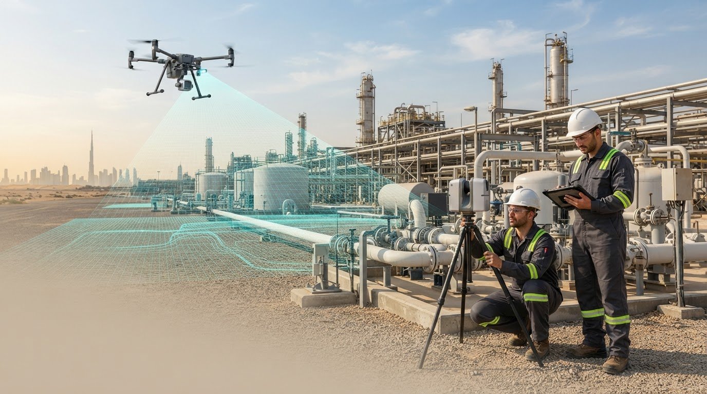
What if a survey captures detailed data but does not answer the project team’s actual question? Precision mapping for oil and gas starts by matching the capture method and deliverable to the asset and the decisions the information needs to support. In Dubai and across the UAE, that means defining the site context, operational constraints, safety requirements, and how teams will use the data after collection.
Facilities, brownfields, and pipeline environments can call for different forms of capture, while project teams may need separate datasets to work together. This guide explains how laser scanning, drone surveys, and GIS support oil and gas applications, and what to define before fieldwork. GEOTECH 3D provides 3D Scanning Oil & Gas and Oil & Gas Surveys, connecting site capture with practical deliverables, from point-cloud data to BIM-ready models compatible with client CAD packages. Use the guidance below to plan coordinated fieldwork and specify asset records that suit the project’s needs.
Key Takeaways
- Precision mapping for oil and gas begins by defining the asset and the decision the spatial data needs to support.
- Laser scanning, drone surveys, and GIS serve different roles. Match each method to the site and the required output.
- Before fieldwork, define the project boundary, access arrangements, operating constraints, intended use, and coordination needs.
- Specify how captured data should be organized and reviewed so project teams can use it downstream.
- GEOTECH 3D provides oil and gas scanning, drone surveys, and GIS capabilities, with a path from point clouds to BIM-ready models compatible with client CAD packages.
Why precision mapping matters for oil and gas assets
Precision mapping for oil and gas is the collection and organization of spatial information for a defined asset or project purpose. It turns site observations into a structured record that teams can use to understand the locations and relationships of relevant features. The right content and format depend on the decisions the information must support.
An existing drawing may be useful for design or reference, but it may not reflect current site conditions. A generalized basemap provides geographic context, not necessarily a detailed record of a particular facility or asset. A mapped record is based on survey data collected for an agreed scope. Its usefulness depends on a clear description of what was surveyed, how the data is organized, and what the deliverable represents. Mapping does not make existing drawings accurate; it gives project teams a basis for reviewing spatial information against the survey scope.
Where oil and gas teams use mapped asset information
Oil and gas facilities and brownfields can include existing structures and site features that teams need to understand in relation to planned work. A mapped view gives the project team a shared spatial reference for discussing those conditions. GEOTECH 3D uses laser scanning to create accurate 3D models of facilities and brownfields. Its oil and gas surveying work also covers pipelines, power plants, and chemical industry projects.
For a pipeline project, spatially organized survey information can help teams consider a route in relation to surrounding site conditions. At a power plant, a mapped record can provide context for planning work around existing assets. These are examples of possible applications, not descriptions of specific GEOTECH 3D projects. Define the survey scope around the asset and the questions the project team needs to answer.
Spatial records also serve a different purpose from geological mapping. A Geological map represents geological features such as rock units and structures. It can provide broader context, but it is not a substitute for a site-specific survey of visible assets and conditions.
What makes mapping useful for project decisions
Useful mapping helps teams coordinate around a consistent understanding of site conditions. Designers can consider surveyed context, project managers can plan work around known assets, and asset owners can review information in relation to the facilities or infrastructure they manage. The value comes from answering a project question, not simply collecting more data.
Start by stating what the record must help the team decide. Is the goal to understand a facility, plan work near existing infrastructure, or create a spatial reference for coordination? The answer guides both the survey scope and the deliverable. A detailed model that does not address the intended use may be less practical than a focused dataset organized for the task.
In Dubai and across the UAE, aligning mapped information with project needs helps teams use survey records more effectively in planning and coordination. Treat the record as information about the agreed survey scope, not as a guarantee of future site conditions.
How precision mapping combines laser scanning, drone surveys, and GIS
Precision mapping for oil and gas can draw on several methods, each suited to a different part of data collection and management. Laser scanning captures spatial data for three-dimensional representation. Drone surveys provide an aerial perspective and can support visual and thermal inspection. GIS organizes spatial information so teams can view and use it in context. These methods can complement one another, but they are not interchangeable. Choose the combination according to the asset, site conditions, and intended deliverable.
What 3D Scanning Oil & Gas contributes
GEOTECH 3D’s 3D Scanning Oil & Gas service uses laser scanning to produce accurate 3D models of oil and gas facilities and brownfields. The point cloud records surveyed surfaces as spatial data and can provide the basis for a model that helps teams interpret existing conditions in three dimensions.
When the project requires a BIM-ready output, GEOTECH 3D can develop point-cloud data into models compatible with client CAD packages. Set the intended model content and level of detail according to how the team will use it. That keeps the deliverable focused on the work rather than adding unnecessary complexity. The Scan to BIM guide explores the point-cloud-to-model workflow in more detail.
When drone surveys and GIS support the mapping scope
Drone-based Oil & Gas Surveys provide another way to collect site information, particularly when aerial coverage or inspection is part of the project need. GEOTECH 3D provides integrated thermal and visual drone inspections that can detect anomalies, cold spots, and internal damages without ground personnel. The DJI Zenmuse H20T is a multi-sensor payload used for fast, accurate data collection.
GIS has a different role. It organizes spatial information into a framework that teams can view and use across project contexts, rather than acting as a field capture method on its own. For example, data from separate assets or work areas can be managed in relation to location and shared project context. The structure should reflect what teams need to understand or coordinate.
Using several methods can connect detailed facility information, aerial survey data, and organized spatial records. The goal is not to use every technology on every site. Instead, align data collection and processing with the asset and the decisions the deliverables must support. GEOTECH 3D’s oil and gas mapping capabilities bring laser scanning, drone surveys, and GIS into a project-specific approach.
Choosing an oil and gas mapping approach for the asset and decision
The right mapping method answers the project question with a suitable deliverable. A facility model, an aerial survey record, and a GIS dataset have different purposes. For precision mapping for oil and gas, define the asset, site conditions, and intended use before deciding whether to use one method or combine several.
| Method | Suitable project context | Intended information output |
|---|---|---|
| Laser scanning | Facilities and brownfields where teams need a detailed three-dimensional representation of surveyed conditions | Point-cloud data and, where required, a 3D model; BIM-ready models can be compatible with client CAD packages |
| Drone surveys | Aerial survey or inspection contexts associated with oil and gas assets, subject to project scope and site conditions | Drone-based survey information or, for integrated thermal and visual inspections, imagery that can help detect anomalies, cold spots, and internal damages |
| GIS | Projects that need spatial information organized for viewing, analysis, or use across asset and work-area contexts | A structured spatial record that helps teams interpret information in its geographic context |
Match the method to the asset and site context
Laser scanning is used to produce accurate 3D models of facilities and brownfields. It is suited to work that depends on understanding the surveyed asset in three dimensions. Drone surveys serve a different role when aerial survey information or visual and thermal inspection is relevant. GIS organizes spatial records rather than replacing field capture. Select methods based on the agreed scope and conditions at the site.
These distinctions help frame work at pipelines, power plants, and chemical industry sites. The asset type alone does not determine the method. A pipeline assignment may call for survey information organized around a project area, while a facility-based question may need a 3D representation. Let the site conditions and required output guide the approach.
Match deliverables to the next project decision
Start with what the team needs to do with the information. Is the requirement a spatial record for reference, a 3D model to understand existing conditions, survey information for a defined scope, or organized data for analysis? A specific answer keeps capture requirements and deliverable expectations aligned.
Point-cloud data, for example, can support the development of BIM-ready models compatible with client CAD packages. If the decision depends on organizing information across work areas, GIS may be central to the deliverable. Drone survey or inspection information addresses a different need. Combining datasets can help when separate questions require distinct outputs, but the scope should state how each dataset will be used. Do not assume methods or outputs are integrated unless the project requirements include that work.
For assets in Dubai and across the UAE, a method comparison is a starting point, not a fixed prescription. Define the decision, identify site constraints, and specify the outputs. GEOTECH 3D scopes oil and gas mapping around those project needs.
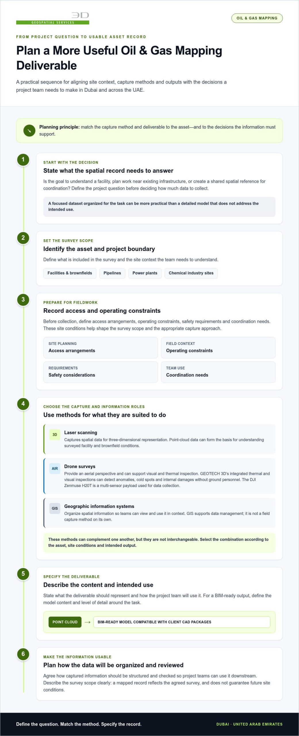
How to plan a precise, safety-focused oil and gas mapping project in the UAE
A clear plan connects the project question to field capture and a usable deliverable. For precision mapping for oil and gas, the asset boundary, operating context, access arrangements, and intended use all shape the survey scope. Addressing these points early helps align fieldwork with site priorities and supports coordination in Dubai and across the UAE.
Define scope before field data collection
Identify the assets to be surveyed and the limits of the work area. Then state the question the mapping must help answer. A facility model, survey information for a pipeline area, and a spatial record for project coordination may call for different capture approaches and outputs.
Before fieldwork, agree on:
- The assets, site boundary, and areas included in the survey.
- The intended use of the mapped information and the teams who will rely on it.
- Access arrangements, relevant operating constraints, and possible fieldwork windows.
- The required deliverables, review approach, and project-specific accuracy expectations.
- Coordination points between the survey team and the site team.
These details make the scope actionable. If a model will inform later design coordination, for example, define the expected model content and how it should relate to the client’s CAD environment. Make accuracy requirements and schedule expectations specific to the asset and task rather than assuming one standard applies to every site.
Coordinate safe capture and review
Operational sites require deliberate field planning. Include safety requirements and site coordination alongside access conditions and the agreed work area. GEOTECH 3D emphasizes strict safety compliance, accurate data collection, and working to tight schedules. Planning should account for those priorities without assuming that every survey can avoid personnel involvement or operational disruption.
A practical project sequence is:
- Confirm the project question, asset boundary, and intended use.
- Discuss site access, operating constraints, schedule expectations, and coordination arrangements.
- Agree on the capture method and define the expected data and deliverables.
- Coordinate field activities with the relevant site team and carry out capture within the agreed scope.
- Review the collected information against the project purpose and agreed deliverable requirements.
Review the deliverable against the defined need: check whether it represents the required areas and whether the output is organized for its next use. If the review identifies a gap against the agreed scope, address it as a project coordination item rather than leaving it to emerge during downstream work.
For oil and gas mapping in the UAE, a clear brief connects site conditions, safety planning, field capture, and usable project information.
From oil and gas field data to usable asset records with GEOTECH 3D
Field data is more useful when its format and organization reflect how project teams will work with it. GEOTECH 3D provides laser-scanning, drone-survey, and GIS capabilities for oil and gas mapping, with the scope shaped around the asset and intended outputs. This gives teams a basis for defining what information to collect and how to present it for review in Dubai and across the UAE.
What GEOTECH 3D brings to oil and gas mapping
3D Scanning Oil & Gas uses laser-scanning technology to develop 3D models of facilities and brownfields. Oil & Gas Surveys and drone-based surveys support other project information needs, while GIS organizes spatial data for use in context. These services apply to work involving facilities, brownfields, pipelines, power plants, and chemical industry sites.
For projects requiring a model-based output, GEOTECH 3D can take raw point-cloud data through to BIM-ready models compatible with client CAD packages. Define the intended users and downstream workflow to clarify which information the asset record should show and how teams will review it.
Define the next step for a UAE project
A productive scope discussion starts with the asset and the work ahead. Set out the site context, project purpose, and expected use of the deliverables. Teams may need a record to support facility documentation, planning, or coordination across a defined asset area. Clarifying priorities connects the required information to a suitable output.
Consider how the resulting record will be used after delivery. Identify the teams that need it, the project activities it should support, and how it should fit alongside existing asset information. Clear expectations help keep the deliverable relevant beyond the immediate capture task.
GEOTECH 3D scopes oil and gas mapping around the asset, required data, and intended outputs. Use the project context to define a focused mapping scope.
Turn your next asset question into a clear mapping brief
Use precision mapping for oil and gas to support decisions, not simply as a one-time data collection exercise. Before the next project phase, identify who will use the spatial information, what they need to resolve, and whether the record should support work beyond the immediate task. Making these expectations explicit keeps the brief focused and the deliverables relevant.
Bring together the people who will define the site scope and use the outputs. Align on the asset area, project purpose, key operating constraints, and how teams need to review the information. This shared brief gives the mapping work direction while allowing capture and deliverables to be tailored to the project.
GEOTECH 3D works with oil and gas teams in Dubai and across the UAE to scope mapping around asset needs, safe coordination, and usable data. Start with the decisions your project needs to support.
A clear brief is the first step toward planning around relevant project information. Begin with the asset question your team needs to answer.
Frequently Asked Questions
What is precision mapping for oil and gas?
It is a spatial record tailored to a defined oil and gas task. The project team determines which asset features need to be represented and how the information will be used. For example, a team preparing a modification may need existing equipment and structures shown in context for review. GEOTECH 3D supports oil and gas mapping with laser scanning, drone surveys, and GIS, scoped to project requirements.
How accurate is oil and gas mapping?
Accuracy requirements depend on the project, so no single figure applies to every survey. Review whether the required areas and features are represented and whether the information meets the agreed project criteria. Before commissioning work, document the accuracy requirement for the intended task and how it will be assessed. GEOTECH 3D describes its oil and gas 3D models as accurate.
Can drones be used for oil and gas surveys?
Yes. Drone surveys can support oil and gas projects when aerial capture suits the asset and site conditions. Define whether the priority is survey information or inspection, which areas are in scope, and how the resulting data will be interpreted. This helps the project team decide whether aerial capture addresses the task or should sit alongside another form of site documentation.
What information should an oil and gas mapping project brief include?
Along with the asset area and project purpose, specify how the team will judge whether the deliverable is complete. Identify the areas or asset features that need to appear in the output and who will review it. State the intended file or model use where known. These details clarify expectations about coverage and review before fieldwork, without assuming technical tolerances or access arrangements.
Does an oil and gas mapping survey require operations to stop?
Operational impact depends on the survey scope and facility conditions. Treat this as a site-specific planning question rather than assuming either uninterrupted operations or a shutdown. Identify the work areas and coordinate sequencing with the relevant site personnel. That helps determine whether access windows or adjustments to planned activities need to be considered.
Can mapped oil and gas data be used for BIM or CAD workflows?
Yes. GEOTECH 3D provides BIM-ready models compatible with client CAD packages. To make the output useful to downstream teams, define the intended model use, the asset elements they need to work with, and how the model will be reviewed. Aligning these expectations early helps the team assess whether the deliverable fits its coordination or documentation workflow.
Search Now
Error: Contact form not found.