

Our Services
Reliable Survey Partner for Dubai Mega Projects: 2026
What if a single millimeter of deviation in your initial site survey could trigger a multi-million dirham rework phase six months into your construction schedule? In the high-stakes environment of Dubai’s 2026 infrastructure boom, you already know that precision isn’t just a technical requirement. It is the foundation of project viability. When you’re managing landmarks that define the city’s skyline, the margin for error effectively disappears. You need a reliable survey partner for mega projects Dubai who understands that data inaccuracies don’t just cause delays; they compromise the integrity of the entire asset lifecycle.
This article outlines the essential criteria for selecting a geospatial partner capable of handling the UAE’s most complex industrial and infrastructure projects. You’ll discover how to achieve zero-error data acquisition through advanced 3D laser scanning and Scan-to-BIM integration. We’ll also examine the necessity of strict compliance with Dubai’s municipal safety standards to prevent costly site shutdowns. By the end of this guide, you’ll have a clear roadmap for securing a partnership that transforms raw spatial data into a high-fidelity digital twin ecosystem, ensuring your project remains on track and fully compliant.
Key Takeaways
- Understand how to avoid multi-million dirham rework costs by prioritizing geospatial precision in the early stages of Dubai’s 2026 infrastructure developments.
- Identify the essential technological capabilities, including mobile mapping and 3D laser scanning, required for rapid and accurate large-scale data acquisition.
- Learn the five key benchmarks for choosing a reliable survey partner for mega projects Dubai, ensuring your consultant meets strict safety and municipal standards.
- Master the workflow of converting complex reality capture data into actionable Scan-to-BIM models and integrated digital twins.
- Discover how local expertise and a proven track record in the UAE help streamline authority approvals and mitigate operational risks.
Why Reliability is Non-Negotiable for Dubai Mega Projects
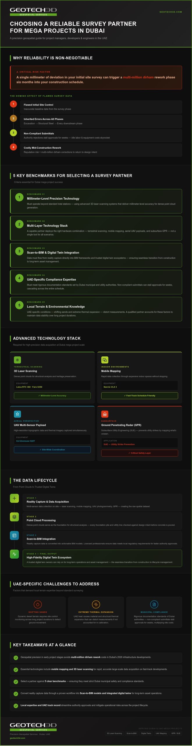
Dubai’s construction landscape in 2026 is defined by unprecedented complexity. Whether it is massive urban expansions or critical energy infrastructure, the margin for error has narrowed to millimeters. In this high-stakes environment, “close enough” is a liability that leads directly to multi-million dollar rework. Selecting a reliable survey partner for mega projects Dubai is the most critical decision a project manager can make to protect the critical path. Accurate geospatial data acts as the project’s single source of truth. It ensures that every foundation pile and utility line aligns perfectly with the design intent before the first drop of concrete is poured.
Surveying delays often create a domino effect. If the initial site control is flawed, every subsequent phase, from excavation to structural steel installation, inherits that error. Correcting these mistakes mid-construction isn’t just expensive; it’s a reputation risk. A trustworthy partner mitigates this by providing high-fidelity data that serves as a reliable foundation for all stakeholders. This proactive approach to risk management keeps projects on schedule and within budget, even as project scopes expand in scale and technical difficulty.
The Stakes of Large-Scale Infrastructure
As we move through 2026, Dubai’s mega projects have evolved into integrated transport networks and smart city expansions. Traditional surveying methods often fail at this scale. They simply can’t capture the density of data required for modern, fast-track workflows. Large sites also face unique environmental challenges. Shifting sands and extreme thermal expansion can distort measurements. If your partner doesn’t account for these UAE-specific conditions, your equipment calibration and data stability will suffer over long project durations. You need a team that understands the local terrain as well as the technology.
Regulatory Alignment and Project Success
Compliance isn’t just about technical accuracy; it’s about navigating the rigorous documentation standards set by Dubai authorities. Non-compliant submittals can stall approvals for weeks. These bottlenecks ripple through the entire schedule, causing idle labor and equipment costs to skyrocket. GEOTECH 3D bridges this gap by leveraging decades of local experience. We act as a reliable survey partner for mega projects Dubai can depend on to ensure every deliverable meets the specific requirements of municipal and utility bodies.
This precision is particularly vital when integrating survey data into Building Information Modeling (BIM) frameworks. By using licensed professionals who understand the nuances of local regulations, developers can secure faster handovers. Reliable data ensures that the transition from construction to asset management is seamless. It gives owners a digital twin they can actually trust for long-term operations.
Advanced Technology Stack for High-Precision Data Acquisition
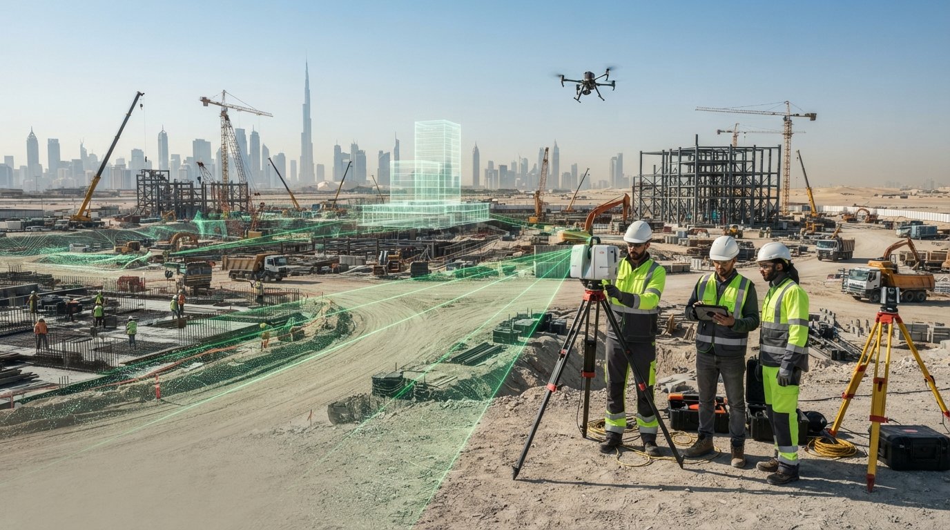
In 2026, the scale of Dubai’s vertical and horizontal infrastructure projects demands more than just standard total stations. Precision is a direct result of combining the right hardware with the technical expertise to deploy it effectively. A reliable survey partner for mega projects Dubai relies on a multi-layered technology stack to capture every detail of the built environment. This ensures that the digital representation of a site matches the physical reality with absolute fidelity.
We utilize the Leica RTC 360 and Faro S350 for high-precision 3D laser scanning. These tools deliver millimeter-level accuracy, creating dense point clouds that serve as the foundation for structural analysis and heritage preservation. For expansive indoor environments, the Navvis VLX 3 mobile mapping system allows for rapid data collection. It captures high-quality spatial data while the operator moves through the site, which is essential for maintaining schedules on fast-track developments.
Aerial perspectives are equally vital for site wide coordination. Using the DJI Zenmuse H20T multi-sensor payload, we capture high-resolution topographic data and thermal imagery simultaneously. This multi-sensor approach provides a comprehensive dataset for large-scale urban expansion projects across the UAE. Beyond what’s visible on the surface, Subsurface Utility Engineering (SUE) using Ground Penetrating Radar (GPR) prevents utility strikes. Mapping the unseen is just as critical as scanning the skyline to ensure site safety.
Reality Capture in Challenging Environments
Brownfield sites and Oil & Gas facilities require a specialized approach that prioritizes safety and operational continuity. These high-risk environments often can’t afford shutdowns for data collection. Our team uses reality capture to document these assets while they remain live. Whether it’s scanning over-ceiling voids or conducting thermal inspections of solar arrays in the Dubai desert, our equipment is calibrated for the UAE’s specific environmental stressors. Professionals looking to modernize their asset management can explore our Drone Services and 3D Laser Scanning solutions to ensure data continuity.
The Speed of Innovation in 2026
Innovation isn’t just about accuracy; it’s about the speed of delivery. Industry professionals often observe that multi-sensor drones can reduce data acquisition time significantly, sometimes cutting field hours by half compared to traditional methods. This efficiency is paired with regional-scale satellite imagery for initial feasibility studies. By combining these diverse data sources, a reliable survey partner for mega projects Dubai provides a holistic view of the site. This ranges from the granular details of a steel connection to the broad contours of a new industrial district, allowing for better-informed decision-making at every level.
5 Criteria for Selecting a Survey Partner in Dubai
Selecting a reliable survey partner for mega projects Dubai involves more than reviewing a hardware inventory. In 2026, the sheer scale of the city’s developments requires a partner that acts as a technical extension of your own team. You need a consultant who doesn’t just deliver data but provides actionable intelligence that fits your specific workflow. This choice determines whether your project proceeds with clarity or founders due to data silos and technical friction.
The first criterion is technical versatility. Can the firm transition seamlessly from a wide-area topographic survey to high-detail Scan-to-BIM? Second, prioritize local presence. A Dubai-based team, such as our specialists in Al Qusais Industrial 3, understands the nuances of local authority liaison and can mobilize rapidly when site conditions change. Third, look for data interoperability. Your partner must ensure that raw data is fully compatible with your CAD and BIM software packages to avoid conversion errors. Finally, a proven track record in specialized sectors like heritage preservation and brownfield industrial sites is non-negotiable. These projects demand a level of meticulousness that standard surveying cannot provide.
Evaluating Safety and Risk Management
Safety protocols for high-risk industrial sites, particularly in the Oil & Gas and Marine sectors, must be rigorous. When vetting a partner, examine their safety manual for specific “confined space” and “shaft” inspection certifications. GEOTECH 3D prioritizes personnel and asset safety by maintaining strict compliance with Dubai’s municipal and industrial standards. This commitment prevents the safety incidents that lead to project shutdowns and legal complications. A partner’s safety record is often a direct reflection of their overall operational precision.
Data Quality and Delivery Standards
In the current project environment, raw point clouds are often insufficient for complex decision-making. You should demand “BIM-ready” models that are structured for immediate use by design and engineering teams. A reliable survey partner for mega projects Dubai should also offer visualization tools like “Bubble View.” These platforms allow stakeholders to conduct remote site inspections and manage assets without physical site visits. This level of transparency ensures long-term data accessibility for future maintenance and expansion, turning a one-time survey into a lasting digital asset.
The Data Lifecycle: From Point Clouds to Digital Twins
The transition from raw spatial data to a functional digital asset requires a methodical approach. It isn’t enough to simply capture points; those points must be contextualized within the project’s broader lifecycle. A reliable survey partner for mega projects Dubai manages this journey through five distinct stages, ensuring that precision remains consistent from the initial topographic survey to the final digital handover.
The lifecycle begins with rapid data acquisition using the 3D scanning and drone technologies we’ve already explored. Once the field teams have captured the reality of the site, the data moves into processing. Here, raw point clouds are converted into detailed 3D Scanning To BIM models. This stage is critical for identifying clashes between as-built conditions and original design intent. These models are then integrated into the GEOVERSE platform, allowing for city-scale modeling and continuous progress monitoring. This real-time spatial analysis provides project managers with the visibility needed to manage large-scale urban expansion or complex industrial brownfields.
Construction progress monitoring involves regular scanning intervals to compare work-in-progress against the BIM model. This allows for immediate detection of structural deviations before they become irreversible. Transitioning to a Digital Twin ensures that the data collected during construction provides value for the next 50 years of the building’s life. It transforms a one-time survey into a persistent management tool that supports every phase of the asset’s existence.
Scan-to-BIM: The Foundation of Modern Construction
Accurate as-built documentation is the most effective way to reduce cost overruns. By capturing the exact position of structural elements and MEP services, we provide a reliable base for engineering teams. This is especially vital for heritage preservation and structural surveys where existing conditions are undocumented. For a deeper look into our methodology, see our 2026 Scan-to-BIM Guide.
GEOVERSE: Managing the Digital Asset
The final stage of the data lifecycle is the transition to a Digital Twin. This isn’t a static model; it’s a living representation of the asset. Leveraging Digital Twins for smart city management allows asset owners to track maintenance schedules and energy consumption in real time. This level of insight is becoming the standard for 2026 developments. By working with a reliable survey partner for mega projects Dubai, you ensure that your digital twin remains a high-fidelity mirror of the physical world. To learn more about this transition, explore our Digital Twin for Asset Lifecycle Guide.
GEOTECH 3D: Your Reliable Survey Partner in Dubai
GEOTECH 3D has evolved alongside the UAE’s skyline, establishing a legacy of precision that spans decades. As a reliable survey partner for mega projects Dubai trusts, we bring more than just equipment to a site; we bring the wisdom of experience. Our role is that of a faithful guide, helping developers and engineers navigate technical transitions with confidence. We understand that in the 2026 construction environment, reliability is measured by the ability to deliver high-fidelity data under tight municipal deadlines.
Our service portfolio is designed to support the entire asset lifecycle. We offer everything from foundational Topographic Mapping to advanced 3D Printing and City Modeling. By utilizing the Navvis VLX 3 and other leading reality capture technologies, we ensure that our clients meet their 2026 milestones. This commitment to innovation allows us to provide solutions that are both aspirational and deeply grounded in technical reality. We don’t just provide data; we provide the security that your project is built on a foundation of absolute accuracy.
Our Specialized Industrial Expertise
We’ve carved out a specialized niche in high-risk and complex environments. GEOTECH 3D leads the market in 3D Scanning for Oil & Gas facilities and brownfield industrial sites where operational continuity is paramount. Our teams also provide specialized support for Marine and Naval construction, as well as sensitive Heritage projects that require a meticulous touch. For project managers overseeing underground infrastructure, you can learn about our Subsurface Utility Engineering in Dubai to understand how we protect existing assets during excavation.
Our local expertise is a significant advantage for our partners. Being based in Dubai means we have an intimate understanding of UAE infrastructure standards and authority requirements. This proximity allows for rapid mobilization and seamless communication throughout the project duration. When you choose a reliable survey partner for mega projects Dubai, you’re choosing a team that is invested in the long-term success of the region’s built environment.
Contact Our Dubai Experts
To discuss the geospatial requirements of your next mega project, you can reach out directly to our senior consultants. We provide the technical clarity needed to plan complex surveys and digital twin integrations from the outset. You can visit our Dubai office or contact us using the details below:
- Location: Ilyaa Tower 2 – Office 101, Damascus St., Al Qusais Industrial 3, Dubai
- Tel: +971 4 295 1589
- Email: info@geotech3d.com
Securing the Future of Dubai’s Built Environment
Precision is the bedrock of every successful development in the UAE. As we manage the complex requirements of 2026, the integration of high-fidelity reality capture with seamless BIM workflows is no longer optional. It’s the primary defense against multi-million dirham rework and project delays. Choosing a reliable survey partner for mega projects Dubai ensures your spatial data remains a strategic asset throughout the entire construction lifecycle and beyond.
GEOTECH 3D stands as a faithful guide for developers and engineers, offering specialized expertise in high-risk Oil & Gas facilities and brownfield industrial sites. By utilizing top-tier hardware like the Navvis VLX 3 and Leica RTC 360, our Dubai-based experts deliver the accuracy required to meet stringent municipal standards. We remain committed to providing the technical clarity and safety compliance that your most ambitious projects demand.
We look forward to helping you transform complex site realities into high-performance digital twins. Let’s build the future of Dubai with absolute precision and shared vision.
Frequently Asked Questions
What makes a survey partner ‘reliable’ for a Dubai mega project?
Reliability is defined by technical versatility, strict safety compliance, and deep local knowledge. A reliable survey partner for mega projects Dubai must possess the capacity to handle multi-layered data acquisition while meeting tight municipal deadlines. This involves maintaining professionally registered licenses across the UAE and demonstrating a proven track record in high-stakes sectors like Oil & Gas. It’s about providing consistent, high-fidelity data that developers can trust for the entire project duration.
How does 3D Laser Scanning improve construction timelines in the UAE?
3D Laser Scanning accelerates schedules by capturing millions of data points in minutes, reducing the time spent on traditional manual measurements. By creating an accurate as-built record from the start, project teams can identify design clashes before construction begins. This proactive approach prevents the costly rework and site shutdowns that often plague large-scale developments. It allows for faster authority approvals and keeps the critical path moving without the friction of data inaccuracies.
What is the difference between Scan-to-BIM and traditional surveying?
Traditional surveying typically focuses on discrete point measurements and 2D layouts. In contrast, Scan-to-BIM involves capturing the entire environment as a high-density point cloud and converting it into a 3D Building Information Model. This provides a holistic digital twin of the structure rather than just isolated coordinates. It enables better collaboration among engineers and architects, ensuring that every structural element and utility line is documented in a three-dimensional, intelligent framework.
Can GEOTECH 3D handle utility mapping for large-scale brownfield sites?
Yes, GEOTECH 3D specializes in comprehensive utility mapping and Subsurface Utility Engineering (SUE) for complex brownfield environments. We use Ground Penetrating Radar (GPR) to locate and map underground assets with high precision. This is vital for industrial facilities and power plants where striking an unknown utility can lead to catastrophic safety incidents and financial losses. Our team ensures all subsurface data is integrated into your existing CAD or GIS packages for seamless planning.
What hardware does GEOTECH 3D use for rapid data acquisition in 2026?
We utilize a cutting-edge technology stack tailored for the 2026 project landscape. This includes the Leica RTC 360 and Faro S350 for static laser scanning, alongside the Navvis VLX 3 for rapid mobile mapping in large indoor spaces. For aerial requirements, we deploy the DJI Zenmuse H20T multi-sensor payload. These tools allow us to capture high-resolution thermal and visual data simultaneously, ensuring that we meet the technical demands of Dubai’s most ambitious infrastructure projects.
How do Digital Twins like GEOVERSE benefit long-term asset management?
Digital Twins created through the GEOVERSE platform provide a living digital mirror of physical assets. This allows owners to track structural health, energy consumption, and maintenance schedules in real time. Instead of relying on static, outdated blueprints, facility managers use the digital twin for spatial analysis and predictive maintenance. It transforms survey data into a persistent management tool that supports the asset’s entire lifecycle, from construction handover to future renovation or decommissioning.
What safety standards are required for surveying in Dubai’s Oil & Gas sector?
Surveying in the Oil & Gas sector requires strict adherence to international and local industrial safety protocols. This includes specific certifications for confined space entry and shaft inspections, alongside the use of intrinsically safe equipment where necessary. GEOTECH 3D maintains a safety-first culture, ensuring all personnel are trained to operate in high-risk brownfield environments. Our compliance with these rigorous standards prevents on-site incidents and ensures that data acquisition doesn’t disrupt critical facility operations.
Does GEOTECH 3D provide services in Abu Dhabi as well as Dubai?
Yes, GEOTECH 3D is fully licensed and registered to operate across the entire United Arab Emirates. While our main office is in Dubai at Al Qusais Industrial 3, we maintain a dedicated presence in Abu Dhabi at Al Shahama Tower 31. This dual-location strategy allows us to mobilize teams rapidly for projects across the UAE. It confirms our position as a reliable survey partner for mega projects Dubai and Abu Dhabi developers can depend on.
What if a single millimeter of deviation in your initial site survey could trigger a multi-million dirham rework phase six months into your construction schedule? In the high-stakes environment of Dubai’s 2026 infrastructure boom, you already know that precision isn’t just a technical requirement. It is the foundation of project viability. When you’re managing landmarks that define the city’s skyline, the margin for error effectively disappears. You need a reliable survey partner for mega projects Dubai who understands that data inaccuracies don’t just cause delays; they compromise the integrity of the entire asset lifecycle.
This article outlines the essential criteria for selecting a geospatial partner capable of handling the UAE’s most complex industrial and infrastructure projects. You’ll discover how to achieve zero-error data acquisition through advanced 3D laser scanning and Scan-to-BIM integration. We’ll also examine the necessity of strict compliance with Dubai’s municipal safety standards to prevent costly site shutdowns. By the end of this guide, you’ll have a clear roadmap for securing a partnership that transforms raw spatial data into a high-fidelity digital twin ecosystem, ensuring your project remains on track and fully compliant.
Key Takeaways
- Understand how to avoid multi-million dirham rework costs by prioritizing geospatial precision in the early stages of Dubai’s 2026 infrastructure developments.
- Identify the essential technological capabilities, including mobile mapping and 3D laser scanning, required for rapid and accurate large-scale data acquisition.
- Learn the five key benchmarks for choosing a reliable survey partner for mega projects Dubai, ensuring your consultant meets strict safety and municipal standards.
- Master the workflow of converting complex reality capture data into actionable Scan-to-BIM models and integrated digital twins.
- Discover how local expertise and a proven track record in the UAE help streamline authority approvals and mitigate operational risks.
Why Reliability is Non-Negotiable for Dubai Mega Projects
Dubai’s construction landscape in 2026 is defined by unprecedented complexity. Whether it is massive urban expansions or critical energy infrastructure, the margin for error has narrowed to millimeters. In this high-stakes environment, “close enough” is a liability that leads directly to multi-million dollar rework. Selecting a reliable survey partner for mega projects Dubai is the most critical decision a project manager can make to protect the critical path. Accurate geospatial data acts as the project’s single source of truth. It ensures that every foundation pile and utility line aligns perfectly with the design intent before the first drop of concrete is poured.
Surveying delays often create a domino effect. If the initial site control is flawed, every subsequent phase, from excavation to structural steel installation, inherits that error. Correcting these mistakes mid-construction isn’t just expensive; it’s a reputation risk. A trustworthy partner mitigates this by providing high-fidelity data that serves as a reliable foundation for all stakeholders. This proactive approach to risk management keeps projects on schedule and within budget, even as project scopes expand in scale and technical difficulty.
The Stakes of Large-Scale Infrastructure
As we move through 2026, Dubai’s mega projects have evolved into integrated transport networks and smart city expansions. Traditional surveying methods often fail at this scale. They simply can’t capture the density of data required for modern, fast-track workflows. Large sites also face unique environmental challenges. Shifting sands and extreme thermal expansion can distort measurements. If your partner doesn’t account for these UAE-specific conditions, your equipment calibration and data stability will suffer over long project durations. You need a team that understands the local terrain as well as the technology.
Regulatory Alignment and Project Success
Compliance isn’t just about technical accuracy; it’s about navigating the rigorous documentation standards set by Dubai authorities. Non-compliant submittals can stall approvals for weeks. These bottlenecks ripple through the entire schedule, causing idle labor and equipment costs to skyrocket. GEOTECH 3D bridges this gap by leveraging decades of local experience. We act as a reliable survey partner for mega projects Dubai can depend on to ensure every deliverable meets the specific requirements of municipal and utility bodies.
This precision is particularly vital when integrating survey data into Building Information Modeling (BIM) frameworks. By using licensed professionals who understand the nuances of local regulations, developers can secure faster handovers. Reliable data ensures that the transition from construction to asset management is seamless. It gives owners a digital twin they can actually trust for long-term operations.
Advanced Technology Stack for High-Precision Data Acquisition
In 2026, the scale of Dubai’s vertical and horizontal infrastructure projects demands more than just standard total stations. Precision is a direct result of combining the right hardware with the technical expertise to deploy it effectively. A reliable survey partner for mega projects Dubai relies on a multi-layered technology stack to capture every detail of the built environment. This ensures that the digital representation of a site matches the physical reality with absolute fidelity.
We utilize the Leica RTC 360 and Faro S350 for high-precision 3D laser scanning. These tools deliver millimeter-level accuracy, creating dense point clouds that serve as the foundation for structural analysis and heritage preservation. For expansive indoor environments, the Navvis VLX 3 mobile mapping system allows for rapid data collection. It captures high-quality spatial data while the operator moves through the site, which is essential for maintaining schedules on fast-track developments.
Aerial perspectives are equally vital for site wide coordination. Using the DJI Zenmuse H20T multi-sensor payload, we capture high-resolution topographic data and thermal imagery simultaneously. This multi-sensor approach provides a comprehensive dataset for large-scale urban expansion projects across the UAE. Beyond what’s visible on the surface, Subsurface Utility Engineering (SUE) using Ground Penetrating Radar (GPR) prevents utility strikes. Mapping the unseen is just as critical as scanning the skyline to ensure site safety.
Reality Capture in Challenging Environments
Brownfield sites and Oil & Gas facilities require a specialized approach that prioritizes safety and operational continuity. These high-risk environments often can’t afford shutdowns for data collection. Our team uses reality capture to document these assets while they remain live. Whether it’s scanning over-ceiling voids or conducting thermal inspections of solar arrays in the Dubai desert, our equipment is calibrated for the UAE’s specific environmental stressors. Professionals looking to modernize their asset management can explore our Drone Services and 3D Laser Scanning solutions to ensure data continuity.
The Speed of Innovation in 2026
Innovation isn’t just about accuracy; it’s about the speed of delivery. Industry professionals often observe that multi-sensor drones can reduce data acquisition time significantly, sometimes cutting field hours by half compared to traditional methods. This efficiency is paired with regional-scale satellite imagery for initial feasibility studies. By combining these diverse data sources, a reliable survey partner for mega projects Dubai provides a holistic view of the site. This ranges from the granular details of a steel connection to the broad contours of a new industrial district, allowing for better-informed decision-making at every level.
5 Criteria for Selecting a Survey Partner in Dubai
Selecting a reliable survey partner for mega projects Dubai involves more than reviewing a hardware inventory. In 2026, the sheer scale of the city’s developments requires a partner that acts as a technical extension of your own team. You need a consultant who doesn’t just deliver data but provides actionable intelligence that fits your specific workflow. This choice determines whether your project proceeds with clarity or founders due to data silos and technical friction.
The first criterion is technical versatility. Can the firm transition seamlessly from a wide-area topographic survey to high-detail Scan-to-BIM? Second, prioritize local presence. A Dubai-based team, such as our specialists in Al Qusais Industrial 3, understands the nuances of local authority liaison and can mobilize rapidly when site conditions change. Third, look for data interoperability. Your partner must ensure that raw data is fully compatible with your CAD and BIM software packages to avoid conversion errors. Finally, a proven track record in specialized sectors like heritage preservation and brownfield industrial sites is non-negotiable. These projects demand a level of meticulousness that standard surveying cannot provide.
Evaluating Safety and Risk Management
Safety protocols for high-risk industrial sites, particularly in the Oil & Gas and Marine sectors, must be rigorous. When vetting a partner, examine their safety manual for specific “confined space” and “shaft” inspection certifications. GEOTECH 3D prioritizes personnel and asset safety by maintaining strict compliance with Dubai’s municipal and industrial standards. This commitment prevents the safety incidents that lead to project shutdowns and legal complications. A partner’s safety record is often a direct reflection of their overall operational precision.
Data Quality and Delivery Standards
In the current project environment, raw point clouds are often insufficient for complex decision-making. You should demand “BIM-ready” models that are structured for immediate use by design and engineering teams. A reliable survey partner for mega projects Dubai should also offer visualization tools like “Bubble View.” These platforms allow stakeholders to conduct remote site inspections and manage assets without physical site visits. This level of transparency ensures long-term data accessibility for future maintenance and expansion, turning a one-time survey into a lasting digital asset.
The Data Lifecycle: From Point Clouds to Digital Twins
The transition from raw spatial data to a functional digital asset requires a methodical approach. It isn’t enough to simply capture points; those points must be contextualized within the project’s broader lifecycle. A reliable survey partner for mega projects Dubai manages this journey through five distinct stages, ensuring that precision remains consistent from the initial topographic survey to the final digital handover.
The lifecycle begins with rapid data acquisition using the 3D scanning and drone technologies we’ve already explored. Once the field teams have captured the reality of the site, the data moves into processing. Here, raw point clouds are converted into detailed 3D Scanning To BIM models. This stage is critical for identifying clashes between as-built conditions and original design intent. These models are then integrated into the GEOVERSE platform, allowing for city-scale modeling and continuous progress monitoring. This real-time spatial analysis provides project managers with the visibility needed to manage large-scale urban expansion or complex industrial brownfields.
Construction progress monitoring involves regular scanning intervals to compare work-in-progress against the BIM model. This allows for immediate detection of structural deviations before they become irreversible. Transitioning to a Digital Twin ensures that the data collected during construction provides value for the next 50 years of the building’s life. It transforms a one-time survey into a persistent management tool that supports every phase of the asset’s existence.
Scan-to-BIM: The Foundation of Modern Construction
Accurate as-built documentation is the most effective way to reduce cost overruns. By capturing the exact position of structural elements and MEP services, we provide a reliable base for engineering teams. This is especially vital for heritage preservation and structural surveys where existing conditions are undocumented. For a deeper look into our methodology, see our 2026 Scan-to-BIM Guide.
GEOVERSE: Managing the Digital Asset
The final stage of the data lifecycle is the transition to a Digital Twin. This isn’t a static model; it’s a living representation of the asset. Leveraging Digital Twins for smart city management allows asset owners to track maintenance schedules and energy consumption in real time. This level of insight is becoming the standard for 2026 developments. By working with a reliable survey partner for mega projects Dubai, you ensure that your digital twin remains a high-fidelity mirror of the physical world. To learn more about this transition, explore our Digital Twin for Asset Lifecycle Guide.
GEOTECH 3D: Your Reliable Survey Partner in Dubai
GEOTECH 3D has evolved alongside the UAE’s skyline, establishing a legacy of precision that spans decades. As a reliable survey partner for mega projects Dubai trusts, we bring more than just equipment to a site; we bring the wisdom of experience. Our role is that of a faithful guide, helping developers and engineers navigate technical transitions with confidence. We understand that in the 2026 construction environment, reliability is measured by the ability to deliver high-fidelity data under tight municipal deadlines.
Our service portfolio is designed to support the entire asset lifecycle. We offer everything from foundational Topographic Mapping to advanced 3D Printing and City Modeling. By utilizing the Navvis VLX 3 and other leading reality capture technologies, we ensure that our clients meet their 2026 milestones. This commitment to innovation allows us to provide solutions that are both aspirational and deeply grounded in technical reality. We don’t just provide data; we provide the security that your project is built on a foundation of absolute accuracy.
Our Specialized Industrial Expertise
We’ve carved out a specialized niche in high-risk and complex environments. GEOTECH 3D leads the market in 3D Scanning for Oil & Gas facilities and brownfield industrial sites where operational continuity is paramount. Our teams also provide specialized support for Marine and Naval construction, as well as sensitive Heritage projects that require a meticulous touch. For project managers overseeing underground infrastructure, you can learn about our Subsurface Utility Engineering in Dubai to understand how we protect existing assets during excavation.
Our local expertise is a significant advantage for our partners. Being based in Dubai means we have an intimate understanding of UAE infrastructure standards and authority requirements. This proximity allows for rapid mobilization and seamless communication throughout the project duration. When you choose a reliable survey partner for mega projects Dubai, you’re choosing a team that is invested in the long-term success of the region’s built environment.
Contact Our Dubai Experts
To discuss the geospatial requirements of your next mega project, you can reach out directly to our senior consultants. We provide the technical clarity needed to plan complex surveys and digital twin integrations from the outset. You can visit our Dubai office or contact us using the details below:
- Location: Ilyaa Tower 2 – Office 101, Damascus St., Al Qusais Industrial 3, Dubai
- Tel: +971 4 295 1589
- Email: info@geotech3d.com
Securing the Future of Dubai’s Built Environment
Precision is the bedrock of every successful development in the UAE. As we manage the complex requirements of 2026, the integration of high-fidelity reality capture with seamless BIM workflows is no longer optional. It’s the primary defense against multi-million dirham rework and project delays. Choosing a reliable survey partner for mega projects Dubai ensures your spatial data remains a strategic asset throughout the entire construction lifecycle and beyond.
GEOTECH 3D stands as a faithful guide for developers and engineers, offering specialized expertise in high-risk Oil & Gas facilities and brownfield industrial sites. By utilizing top-tier hardware like the Navvis VLX 3 and Leica RTC 360, our Dubai-based experts deliver the accuracy required to meet stringent municipal standards. We remain committed to providing the technical clarity and safety compliance that your most ambitious projects demand.
We look forward to helping you transform complex site realities into high-performance digital twins. Let’s build the future of Dubai with absolute precision and shared vision.
Frequently Asked Questions
What makes a survey partner ‘reliable’ for a Dubai mega project?
Reliability is defined by technical versatility, strict safety compliance, and deep local knowledge. A reliable survey partner for mega projects Dubai must possess the capacity to handle multi-layered data acquisition while meeting tight municipal deadlines. This involves maintaining professionally registered licenses across the UAE and demonstrating a proven track record in high-stakes sectors like Oil & Gas. It’s about providing consistent, high-fidelity data that developers can trust for the entire project duration.
How does 3D Laser Scanning improve construction timelines in the UAE?
3D Laser Scanning accelerates schedules by capturing millions of data points in minutes, reducing the time spent on traditional manual measurements. By creating an accurate as-built record from the start, project teams can identify design clashes before construction begins. This proactive approach prevents the costly rework and site shutdowns that often plague large-scale developments. It allows for faster authority approvals and keeps the critical path moving without the friction of data inaccuracies.
What is the difference between Scan-to-BIM and traditional surveying?
Traditional surveying typically focuses on discrete point measurements and 2D layouts. In contrast, Scan-to-BIM involves capturing the entire environment as a high-density point cloud and converting it into a 3D Building Information Model. This provides a holistic digital twin of the structure rather than just isolated coordinates. It enables better collaboration among engineers and architects, ensuring that every structural element and utility line is documented in a three-dimensional, intelligent framework.
Can GEOTECH 3D handle utility mapping for large-scale brownfield sites?
Yes, GEOTECH 3D specializes in comprehensive utility mapping and Subsurface Utility Engineering (SUE) for complex brownfield environments. We use Ground Penetrating Radar (GPR) to locate and map underground assets with high precision. This is vital for industrial facilities and power plants where striking an unknown utility can lead to catastrophic safety incidents and financial losses. Our team ensures all subsurface data is integrated into your existing CAD or GIS packages for seamless planning.
What hardware does GEOTECH 3D use for rapid data acquisition in 2026?
We utilize a cutting-edge technology stack tailored for the 2026 project landscape. This includes the Leica RTC 360 and Faro S350 for static laser scanning, alongside the Navvis VLX 3 for rapid mobile mapping in large indoor spaces. For aerial requirements, we deploy the DJI Zenmuse H20T multi-sensor payload. These tools allow us to capture high-resolution thermal and visual data simultaneously, ensuring that we meet the technical demands of Dubai’s most ambitious infrastructure projects.
How do Digital Twins like GEOVERSE benefit long-term asset management?
Digital Twins created through the GEOVERSE platform provide a living digital mirror of physical assets. This allows owners to track structural health, energy consumption, and maintenance schedules in real time. Instead of relying on static, outdated blueprints, facility managers use the digital twin for spatial analysis and predictive maintenance. It transforms survey data into a persistent management tool that supports the asset’s entire lifecycle, from construction handover to future renovation or decommissioning.
What safety standards are required for surveying in Dubai’s Oil & Gas sector?
Surveying in the Oil & Gas sector requires strict adherence to international and local industrial safety protocols. This includes specific certifications for confined space entry and shaft inspections, alongside the use of intrinsically safe equipment where necessary. GEOTECH 3D maintains a safety-first culture, ensuring all personnel are trained to operate in high-risk brownfield environments. Our compliance with these rigorous standards prevents on-site incidents and ensures that data acquisition doesn’t disrupt critical facility operations.
Does GEOTECH 3D provide services in Abu Dhabi as well as Dubai?
Yes, GEOTECH 3D is fully licensed and registered to operate across the entire United Arab Emirates. While our main office is in Dubai at Al Qusais Industrial 3, we maintain a dedicated presence in Abu Dhabi at Al Shahama Tower 31. This dual-location strategy allows us to mobilize teams rapidly for projects across the UAE. It confirms our position as a reliable survey partner for mega projects Dubai and Abu Dhabi developers can depend on.
Search Now
Error: Contact form not found.