

Our Services
Scan to BIM Services Price in UAE: 2026 Commercial Cost Guide
Relying on a flat square-meter rate to budget reality capture is the quickest way to compromise a commercial development or retrofit in Dubai. When evaluating the Scan to BIM services price UAE vendors submit for tender, you’ve likely noticed that commercial proposals for the exact same physical footprint can vary wildly.
It’s understandable to feel frustrated when ambiguous Level of Development (LOD) definitions, hidden discipline exclusions, and vague scopes turn an initial tender into unexpected site variations and costly design clashes. True reality capture pricing doesn’t rely on generic benchmarks; it reflects spatial complexity, operational site accessibility, and the precise depth of information your engineering team requires. In this guide, you’ll discover how commercial proposals are structured across the Emirates, how to draft an airtight Scope of Work to secure competitive bids, and how to verify vendor modeling capabilities before signing a contract. The following breakdown provides the clarity you need to budget accurately and protect your project milestones from start to finish.
Key Takeaways
- Understand the core framework defining the Scan to BIM services price UAE vendors charge, distinguishing field capture costs from point-cloud modeling phases.
- Identify how specific Level of Development (LOD) parameters and MEP discipline inclusions directly govern drafting labor and overall commercial expenditure.
- Discover how hardware selection, ranging from high-precision terrestrial scanners to mobile mapping platforms, controls on-site surveying duration.
- Learn the essential verification steps required to audit reality capture bids across Dubai and Abu Dhabi to eliminate scope gaps and variation claims.
- Explore how partnering with an end-to-end reality capture specialist protects downstream engineering accuracy and accelerates construction timelines.
Understanding Scan to BIM Services Price Structures in the UAE
Scan to BIM pricing in the UAE is governed by architectural complexity, required Level of Development, and on-site access logistics rather than simple gross floor area. Commercial proposals for reality capture combine two distinct operational phases: physical field data capture and downstream office point-cloud-to-BIM modeling. Across Dubai and Abu Dhabi, surveying firms structure their commercial proposals using either milestone deliverables or area-based complexity frameworks. Committing to accurate reality capture early prevents expensive on-site rework, eliminates spatial clashes during MEP fit-out, and establishes a dependable foundation for Building Information Modeling lifecycle management. When assessing the overall Scan to BIM services price UAE project teams receive, understanding these individual cost layers prevents unexpected budget overruns.
The Two-Part Cost Structure: Field Scanning vs. BIM Modeling
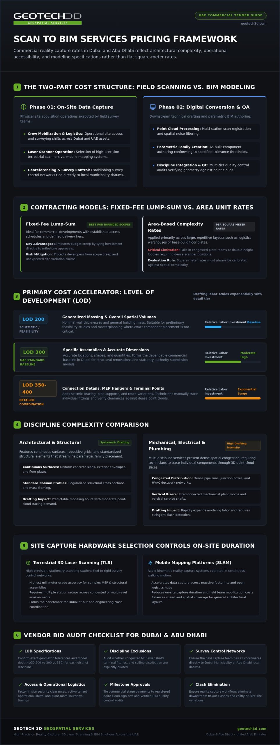
Every reality capture budget splits into on-site acquisition and digital conversion. Field capture encompasses crew mobilization, laser scanner operation, georeferencing, and establishing survey control networks tied to local municipality datums. Office modeling requires point cloud registration, spatial noise filtering, parametric family creation, and stringent quality control audits. Modeling labor scales rapidly depending on discipline integration; authoring structural concrete and architectural envelopes requires less drafting time than coordinating dense MEP riser shafts and ceiling service distribution networks.
Why Lump-Sum Proposals Differ from Unit-Rate Pricing
Procurement teams across the Emirates typically encounter two contracting models:
- Fixed-Fee Lump-Sum: Best suited for commercial assets with clearly bounded scopes, complete access schedules, and defined delivery tiers. This structure protects developers from budget creep by fixing the total investment against agreed milestone approvals.
- Area-Based Complexity Rates: Applied frequently across large, repetitive footprints such as logistics warehouses or base-build office floors. However, flat per-square-meter rates collapse when applied to congested mechanical plant rooms or double-height lobbies requiring dense scanner positions.
Evaluating commercial proposals requires weighing site conditions against design requirements. Reviewing specialized operational workflows with GEOTECH 3D for Scan to BIM solutions ensures your project secures an accurate scope without unaccounted variations.
Primary Pricing Drivers: LOD, Disciplines, and Project Scope
Point cloud capture gathers raw spatial data, but modeling specifications dictate the actual drafting hours. When evaluating the Scan to BIM services price UAE survey vendors quote, Level of Development (LOD) and discipline density represent the most decisive cost accelerators. Clear geometric tolerances prevent asset owners from paying for microscopic accuracy on non-critical architectural assemblies while ensuring vital structural connections receive proper coordination.
Level of Development (LOD 200 vs. LOD 300 vs. LOD 350+)
Labor investment scales exponentially as modeling depth increases across project phases:
- LOD 200: Delivers generalized massing, overall spatial volumes, and nominal wall thicknesses. This tier works well for preliminary feasibility studies and masterplanning where exact component placement isn’t critical.
- LOD 300: Represents elements as specific assemblies with accurate dimensions, locations, shapes, and quantities. In Dubai, this level forms the reliable baseline for structural renovations and regulatory submission models.
- LOD 350 to 400: Adds connection details, seismic bracing, MEP hangers, and exact terminal points. Modeling time expands significantly because technicians must manually verify individual fittings and route variations against the point cloud.
Discipline Density: Architectural, Structural, and MEP Systems
Every added discipline compounds the technical complexity of the model. Architectural and structural modeling involves continuous surfaces, uniform slabs, and standard column profiles, which allows for systematic component placement. In contrast, mechanical, electrical, and plumbing (MEP) systems require extensive drafting labor. Technicians must trace dense pipe runs, junction boxes, and HVAC ductwork through point cloud slices, verifying slopes and clear heights at every step.
Over-ceiling service networks and congested plant rooms compound field and office costs. Capturing obscured ductwork requires dense tripod setups or specialized equipment, expanding site hours and subsequent model registration. Specifying high-density LOD 350 modeling only for active MEP coordination zones while maintaining LOD 200 for shell spaces keeps budgets controlled. Partnering with GEOTECH 3D allows developers to configure precise scope matrices that align reality capture deliverables with actual engineering milestones, ensuring your commercial proposal remains focused and competitive.
Site Capture Variables: How Hardware Selection Influences Project Costs
Field data collection represents the initial operational hurdle of reality capture. Hardware selection directly influences site labor expenditure and determines the overall Scan to BIM services price UAE clients encounter. Utilizing the proper instrument for each spatial context prevents extended surveying schedules while guaranteeing accurate registration for downstream modeling.
Terrestrial Laser Scanners: Faro S350 and Leica RTC 360
High-precision static instruments like the Faro S350 and Leica RTC 360 deliver millimeter-grade point clouds. These units excel when auditing structural deformations, detailed facades, and tight-tolerance industrial assemblies. Setting up stationary tripod positions across complex environments demands meticulous planning, individual scan registrations, and survey control network verification. While static scanning requires more field time, it yields clean, dense point clouds that reduce digital post-processing and surface extraction hours back in the office.
Mobile Reality Capture with the Navvis VLX 3
Wearable mobile mapping systems cut on-site capture time substantially. Deploying the Navvis VLX 3 allows surveyors to walk through vast commercial assets, logistics hubs, and open corporate layouts while capturing complete panoramic imagery and point cloud data simultaneously. Continuous SLAM (Simultaneous Localization and Mapping) technology cuts field duration from days to hours, limiting operational interruptions in active retail or operational environments.
Deploying a hybrid reality capture strategy delivers optimal efficiency across diverse project scopes:
- Mobile Mapping for Open Zones: Utilize the Navvis VLX 3 across expansive corridors, open-plan workspaces, and extensive baseline architectural footprints.
- Terrestrial Scans for MEP Zones: Position static scanners like the Leica RTC 360 within dense electrical substations, central chiller plants, and intricate service shafts.
- Targeted In-Ceiling Scans: Utilize elevated static positions to scan over-ceiling spaces without requiring total ceiling grid demolition.
Value-Added Reality Deliverables: Interactive Bubble Views
Point clouds can prove cumbersome for non-technical stakeholders to navigate. Integrating high-resolution bubble view panoramas allows project managers, facility operators, and structural consultants to walk through the digital site from standard web browsers without native BIM software. Visual 360-degree context accelerates design team coordination and streamlines site condition audits. Connecting reality capture data with broader asset workflows provides lasting value across construction and renovation lifecycles through solutions like the GEOVERSE Digital Twin platform.
How to Evaluate Scan to BIM Quotes in Dubai and Abu Dhabi
Procurement teams across Dubai and Abu Dhabi regularly encounter wide price disparities when tendering reality capture packages. A seemingly attractive initial bid often masks critical technical exclusions that later surface as costly variation claims during design or fit-out. When evaluating the Scan to BIM services price UAE vendors submit, examining the underlying technical methodology is just as critical as reviewing bottom-line numbers. A comprehensive commercial proposal must clearly specify field acquisition protocols, local geodetic coordinate integration, modeling tolerance thresholds, and target digital deliverables.
Essential Items Every Scope of Work (SOW) Must Define
Preventing scope ambiguity starts with an explicit, technically bounded Scope of Work. Ensure tender documentation establishes:
- Defined Spatial Boundaries: Clarify exact floor levels, tenant demising partitions, plant rooms, and exterior envelope requirements to prevent unexpected demarcation disputes.
- Target Deliverable Formats: Establish the native Autodesk Revit version, object family naming conventions, and open IFC schema configurations required for client handover.
- Survey Control Integration: Mandate that point clouds register to Dubai Local Grid (DLTM) or Abu Dhabi survey datums to ensure seamless coordination with civil and structural designs.
- Operational Logistics: Define safety inductions, restricted working windows, night-shift mobilization allowances, and required municipal access permits.
Vetting Geospatial Vendors: Avoiding Hidden Variation Fees
Dissecting contractor proposals protects project schedules from unbudgeted extras. Discounted bids frequently omit congested above-ceiling plenum spaces, riser shafts, or comprehensive clash detection reporting against design documentation. Untested vendors may also introduce sudden variation fees when secondary site mobilizations are required to rescan occluded areas.
Request written confirmation that the vendor deploys direct in-house surveying teams and fully calibrated equipment rather than unvetted sub-consultants. Review their documented quality assurance process; reliable proposals explicitly state root-mean-square (RMS) registration error thresholds and verify that modeling tolerances stay within acceptable engineering limits.
Selecting GEOTECH 3D for Cost-Effective Scan to BIM in the UAE
Securing a dependable reality capture partner eliminates the friction between raw field measurement and operational design execution. GEOTECH 3D delivers end-to-end reality capture and 3D Scanning To BIM solutions tailored to major developers, contractors, and asset owners across the Emirates. By operating an advanced hardware fleet, including the Faro S350, Leica RTC 360, and Navvis VLX 3, our teams achieve exceptional capture efficiency without sacrificing geometric accuracy. This direct alignment between field acquisition and internal modeling teams optimizes the overall Scan to BIM services price UAE clients encounter, replacing fragmented subcontractor layers with a single accountable partner.
Comprehensive Reality Capture and Digital Twin Capabilities
Complex existing buildings demand versatile technical solutions. GEOTECH 3D manages challenging indoor, outdoor, and over-ceiling environments to document concealed services and primary structures with equal fidelity. Spatial datasets can also feed directly into the Geoverse platform to power smart facility management and comprehensive digital twin initiatives. Projects requiring holistic site intelligence can combine reality capture with full-scope geospatial offerings:
- Topographic Surveys: Establish dependable surface baselines and boundary verifications before breaking ground.
- Subsurface Utilities Mapping: Deploy Ground Penetrating Radar (GPR) to resolve buried infrastructure conflicts prior to renovation or excavation.
- Interactive Panoramic Deliverables: Combine native BIM models with 360-degree bubble view tours for intuitive site inspections across remote teams.
Requesting a Project-Specific Scan to BIM Commercial Proposal
Transparent commercial proposals demand clear technical parameters. When submitting an RFP for 3D Scanning To BIM, providing your project location, approximate floor area, available archive drawings, and target LOD allows our engineers to calculate exact scanning setups and modeling hours. This structured scoping eliminates unexpected budget variations and ensures the Scan to BIM services price UAE project leaders receive reflects realistic project milestones.
Headquartered in Dubai at Ilyaa Tower 2, with dedicated operations in Abu Dhabi, GEOTECH 3D mobilizes quickly across commercial, industrial, and infrastructure developments. Connect with our engineering department to review your site parameters and schedule an exploratory consultation with GEOTECH 3D geospatial experts today.
Achieving Commercial Precision in UAE Reality Capture
Navigating reality capture tenders requires balancing technical detail with commercial reality. Establishing explicit LOD boundaries, defining MEP discipline requirements, and selecting the right mix of static and mobile mapping hardware ensures your investment protects downstream engineering workflows. When assessing the Scan to BIM services price UAE surveying firms quote, choosing an accountable partner with documented quality control prevents costly on-site clashes and unexpected variation claims.
GEOTECH 3D supports developers, consultants, and contractors across Dubai and Abu Dhabi with responsive field surveying and dependable digital modeling. Operating advanced Faro S350, Leica RTC 360, and Navvis VLX 3 systems, our local engineering teams capture challenging indoor, outdoor, and congested over-ceiling environments with millimeter confidence.
Your construction and renovation milestones depend on an uncompromised spatial foundation. Partnering with proven reality capture professionals gives your team the accuracy needed to deliver complex assets on schedule and within budget.
Frequently Asked Questions
How is Scan to BIM services price calculated for commercial properties in the UAE?
Scan to BIM services price UAE calculations depend on a two-part valuation dividing on-site reality capture from digital Revit modeling. Surveyors evaluate gross area, architectural layout complexity, accessibility, and the required Level of Development. Clear scopes allow vendors to offer fixed lump-sum milestones, whereas expansive, uniform spaces might use area-based complexity metrics. Factors like night-shift operations or high ceiling clearances also shape the final quotation.
What is the price difference between an LOD 200 and an LOD 350 BIM model?
An LOD 350 model demands substantially more modeling time than an LOD 200 deliverable, directly multiplying office labor investment. LOD 200 focuses purely on schematic geometry, overall massing, and generalized spatial clearances. In contrast, LOD 350 requires precise modeling of secondary components, connection details, support hangers, and individual clash-tested MEP fittings. This extra geometric detail and verification rigor naturally result in higher quotation totals.
Does scanning MEP systems and over-ceiling spaces increase project quotation costs?
Yes, capturing MEP networks and above-ceiling voids increases commercial fees because it demands specialized site capture techniques and dense technician hours. Field crews must position static scanners on elevated stands or navigate confined ceiling access panels, which slows field progress. Back in the office, BIM modelers must manually trace complex ductwork, conduit runs, and pipe slopes through congested point cloud cross-sections rather than placing standard parametric walls.
Can mobile laser scanning reduce the overall price of a Scan to BIM project?
Mobile reality capture can reduce overall project expenditure by significantly cutting field duration across large, unobstructed areas. Systems like the Navvis VLX 3 collect dense spatial data while moving at walking speed, completing open floorplates in hours rather than days. Shorter on-site deployment decreases field labor costs, minimizes operational site disruptions, and accelerates the point cloud handover to downstream BIM modeling teams.
What information do I need to provide to receive an accurate Scan to BIM quote?
To receive an accurate Scan to BIM services price UAE proposal, you should share your property location, gross floor area, and existing 2D CAD or PDF layouts. Clearly specify your required Level of Development, target disciplines (architectural, structural, MEP), and software delivery versions. Detailing site access schedules, ceiling grid status, and local grid coordination requirements helps surveying teams prepare comprehensive proposals without contingency padding.
How does Scan to BIM compare in cost to traditional 2D as-built measured surveys?
While an initial 3D laser scanning proposal may carry a higher upfront cost than manual 2D tape-and-disto surveying, it delivers far greater lifecycle value. Traditional methods often miss hidden structural deviations and produce incomplete documentation that causes on-site design clashes. Scan to BIM provides millimeter-accurate, clash-free parametric models and panoramic bubble views, preventing expensive rework and schedule delays during subsequent fit-out or construction phases.
Are site permits and local authority coordination included in Scan to BIM pricing in Dubai?
Permit requirements vary across different jurisdictions, so proposals must explicitly state whether statutory coordination is covered. Standard reality capture bids generally encompass basic surveyor gate passes, but security clearances for critical infrastructure, specialized developer access permits, or municipality coordination may be quoted separately. Always confirm whether your surveying vendor handles developer NOCs, community security passes, and local municipality grid tie-in approvals within their initial commercial scope.

Relying on a flat square-meter rate to budget reality capture is the quickest way to compromise a commercial development or retrofit in Dubai. When evaluating the Scan to BIM services price UAE vendors submit for tender, you’ve likely noticed that commercial proposals for the exact same physical footprint can vary wildly.
It’s understandable to feel frustrated when ambiguous Level of Development (LOD) definitions, hidden discipline exclusions, and vague scopes turn an initial tender into unexpected site variations and costly design clashes. True reality capture pricing doesn’t rely on generic benchmarks; it reflects spatial complexity, operational site accessibility, and the precise depth of information your engineering team requires. In this guide, you’ll discover how commercial proposals are structured across the Emirates, how to draft an airtight Scope of Work to secure competitive bids, and how to verify vendor modeling capabilities before signing a contract. The following breakdown provides the clarity you need to budget accurately and protect your project milestones from start to finish.
Key Takeaways
- Understand the core framework defining the Scan to BIM services price UAE vendors charge, distinguishing field capture costs from point-cloud modeling phases.
- Identify how specific Level of Development (LOD) parameters and MEP discipline inclusions directly govern drafting labor and overall commercial expenditure.
- Discover how hardware selection, ranging from high-precision terrestrial scanners to mobile mapping platforms, controls on-site surveying duration.
- Learn the essential verification steps required to audit reality capture bids across Dubai and Abu Dhabi to eliminate scope gaps and variation claims.
- Explore how partnering with an end-to-end reality capture specialist protects downstream engineering accuracy and accelerates construction timelines.
Understanding Scan to BIM Services Price Structures in the UAE
Scan to BIM pricing in the UAE is governed by architectural complexity, required Level of Development, and on-site access logistics rather than simple gross floor area. Commercial proposals for reality capture combine two distinct operational phases: physical field data capture and downstream office point-cloud-to-BIM modeling. Across Dubai and Abu Dhabi, surveying firms structure their commercial proposals using either milestone deliverables or area-based complexity frameworks. Committing to accurate reality capture early prevents expensive on-site rework, eliminates spatial clashes during MEP fit-out, and establishes a dependable foundation for Building Information Modeling lifecycle management. When assessing the overall Scan to BIM services price UAE project teams receive, understanding these individual cost layers prevents unexpected budget overruns.
The Two-Part Cost Structure: Field Scanning vs. BIM Modeling
Every reality capture budget splits into on-site acquisition and digital conversion. Field capture encompasses crew mobilization, laser scanner operation, georeferencing, and establishing survey control networks tied to local municipality datums. Office modeling requires point cloud registration, spatial noise filtering, parametric family creation, and stringent quality control audits. Modeling labor scales rapidly depending on discipline integration; authoring structural concrete and architectural envelopes requires less drafting time than coordinating dense MEP riser shafts and ceiling service distribution networks. Technical engineering consultancies such as RTG Engenharia demonstrate that precise technical development within a BIM environment is essential to managing this complexity and preventing coordination errors.
Why Lump-Sum Proposals Differ from Unit-Rate Pricing
Procurement teams across the Emirates typically encounter two contracting models:
- Fixed-Fee Lump-Sum: Best suited for commercial assets with clearly bounded scopes, complete access schedules, and defined delivery tiers. This structure protects developers from budget creep by fixing the total investment against agreed milestone approvals.
- Area-Based Complexity Rates: Applied frequently across large, repetitive footprints such as logistics warehouses or base-build office floors. However, flat per-square-meter rates collapse when applied to congested mechanical plant rooms or double-height lobbies requiring dense scanner positions.
Evaluating commercial proposals requires weighing site conditions against design requirements. Reviewing specialized operational workflows with GEOTECH 3D for Scan to BIM solutions ensures your project secures an accurate scope without unaccounted variations.
Primary Pricing Drivers: LOD, Disciplines, and Project Scope
Point cloud capture gathers raw spatial data, but modeling specifications dictate the actual drafting hours. When evaluating the Scan to BIM services price UAE survey vendors quote, Level of Development (LOD) and discipline density represent the most decisive cost accelerators. Clear geometric tolerances prevent asset owners from paying for microscopic accuracy on non-critical architectural assemblies while ensuring vital structural connections receive proper coordination.
Level of Development (LOD 200 vs. LOD 300 vs. LOD 350+)
Labor investment scales exponentially as modeling depth increases across project phases:
- LOD 200: Delivers generalized massing, overall spatial volumes, and nominal wall thicknesses. This tier works well for preliminary feasibility studies and masterplanning where exact component placement isn’t critical.
- LOD 300: Represents elements as specific assemblies with accurate dimensions, locations, shapes, and quantities. In Dubai, this level forms the reliable baseline for structural renovations and regulatory submission models.
- LOD 350 to 400: Adds connection details, seismic bracing, MEP hangers, and exact terminal points. Modeling time expands significantly because technicians must manually verify individual fittings and route variations against the point cloud.
Discipline Density: Architectural, Structural, and MEP Systems
Every added discipline compounds the technical complexity of the model. Architectural and structural modeling involves continuous surfaces, uniform slabs, and standard column profiles, which allows for systematic component placement. In contrast, mechanical, electrical, and plumbing (MEP) systems require extensive drafting labor. Technicians must trace dense pipe runs, junction boxes, and HVAC ductwork through point cloud slices, verifying slopes and clear heights at every step.
Over-ceiling service networks and congested plant rooms compound field and office costs. Capturing obscured ductwork requires dense tripod setups or specialized equipment, expanding site hours and subsequent model registration. Specifying high-density LOD 350 modeling only for active MEP coordination zones while maintaining LOD 200 for shell spaces keeps budgets controlled. Partnering with GEOTECH 3D allows developers to configure precise scope matrices that align reality capture deliverables with actual engineering milestones, ensuring your commercial proposal remains focused and competitive.
Site Capture Variables: How Hardware Selection Influences Project Costs
Field data collection represents the initial operational hurdle of reality capture. Hardware selection directly influences site labor expenditure and determines the overall Scan to BIM services price UAE clients encounter. Utilizing the proper instrument for each spatial context prevents extended surveying schedules while guaranteeing accurate registration for downstream modeling.
Terrestrial Laser Scanners: Faro S350 and Leica RTC 360
High-precision static instruments like the Faro S350 and Leica RTC 360 deliver millimeter-grade point clouds. These units excel when auditing structural deformations, detailed facades, and tight-tolerance industrial assemblies. Setting up stationary tripod positions across complex environments demands meticulous planning, individual scan registrations, and survey control network verification. While static scanning requires more field time, it yields clean, dense point clouds that reduce digital post-processing and surface extraction hours back in the office.
Mobile Reality Capture with the Navvis VLX 3
Wearable mobile mapping systems cut on-site capture time substantially. Deploying the Navvis VLX 3 allows surveyors to walk through vast commercial assets, logistics hubs, and open corporate layouts while capturing complete panoramic imagery and point cloud data simultaneously. Continuous SLAM (Simultaneous Localization and Mapping) technology cuts field duration from days to hours, limiting operational interruptions in active retail or operational environments.
Deploying a hybrid reality capture strategy delivers optimal efficiency across diverse project scopes:
- Mobile Mapping for Open Zones: Utilize the Navvis VLX 3 across expansive corridors, open-plan workspaces, and extensive baseline architectural footprints.
- Terrestrial Scans for MEP Zones: Position static scanners like the Leica RTC 360 within dense electrical substations, central chiller plants, and intricate service shafts.
- Targeted In-Ceiling Scans: Utilize elevated static positions to scan over-ceiling spaces without requiring total ceiling grid demolition.
Value-Added Reality Deliverables: Interactive Bubble Views
Point clouds can prove cumbersome for non-technical stakeholders to navigate. Integrating high-resolution bubble view panoramas allows project managers, facility operators, and structural consultants to walk through the digital site from standard web browsers without native BIM software. Visual 360-degree context accelerates design team coordination and streamlines site condition audits. Connecting reality capture data with broader asset workflows provides lasting value across construction and renovation lifecycles through solutions like the GEOVERSE Digital Twin platform.
How to Evaluate Scan to BIM Quotes in Dubai and Abu Dhabi
Procurement teams across Dubai and Abu Dhabi regularly encounter wide price disparities when tendering reality capture packages. A seemingly attractive initial bid often masks critical technical exclusions that later surface as costly variation claims during design or fit-out. When evaluating the Scan to BIM services price UAE vendors submit, examining the underlying technical methodology is just as critical as reviewing bottom-line numbers. A comprehensive commercial proposal must clearly specify field acquisition protocols, local geodetic coordinate integration, modeling tolerance thresholds, and target digital deliverables.
Essential Items Every Scope of Work (SOW) Must Define
Preventing scope ambiguity starts with an explicit, technically bounded Scope of Work. Ensure tender documentation establishes:
- Defined Spatial Boundaries: Clarify exact floor levels, tenant demising partitions, plant rooms, and exterior envelope requirements to prevent unexpected demarcation disputes.
- Target Deliverable Formats: Establish the native Autodesk Revit version, object family naming conventions, and open IFC schema configurations required for client handover.
- Survey Control Integration: Mandate that point clouds register to Dubai Local Grid (DLTM) or Abu Dhabi survey datums to ensure seamless coordination with civil and structural designs.
- Operational Logistics: Define safety inductions, restricted working windows, night-shift mobilization allowances, and required municipal access permits.
Vetting Geospatial Vendors: Avoiding Hidden Variation Fees
Dissecting contractor proposals protects project schedules from unbudgeted extras. Discounted bids frequently omit congested above-ceiling plenum spaces, riser shafts, or comprehensive clash detection reporting against design documentation. Untested vendors may also introduce sudden variation fees when secondary site mobilizations are required to rescan occluded areas.
Request written confirmation that the vendor deploys direct in-house surveying teams and fully calibrated equipment rather than unvetted sub-consultants. Review their documented quality assurance process; reliable proposals explicitly state root-mean-square (RMS) registration error thresholds and verify that modeling tolerances stay within acceptable engineering limits.
Selecting GEOTECH 3D for Cost-Effective Scan to BIM in the UAE
Securing a dependable reality capture partner eliminates the friction between raw field measurement and operational design execution. GEOTECH 3D delivers end-to-end reality capture and 3D Scanning To BIM solutions tailored to major developers, contractors, and asset owners across the Emirates. By operating an advanced hardware fleet, including the Faro S350, Leica RTC 360, and Navvis VLX 3, our teams achieve exceptional capture efficiency without sacrificing geometric accuracy. This direct alignment between field acquisition and internal modeling teams optimizes the overall Scan to BIM services price UAE clients encounter, replacing fragmented subcontractor layers with a single accountable partner.
Comprehensive Reality Capture and Digital Twin Capabilities
Complex existing buildings demand versatile technical solutions. GEOTECH 3D manages challenging indoor, outdoor, and over-ceiling environments to document concealed services and primary structures with equal fidelity. Spatial datasets can also feed directly into the Geoverse platform to power smart facility management and comprehensive digital twin initiatives. Projects requiring holistic site intelligence can combine reality capture with full-scope geospatial offerings:
- Topographic Surveys: Establish dependable surface baselines and boundary verifications before breaking ground.
- Subsurface Utilities Mapping: Deploy Ground Penetrating Radar (GPR) to resolve buried infrastructure conflicts prior to renovation or excavation.
- Interactive Panoramic Deliverables: Combine native BIM models with 360-degree bubble view tours for intuitive site inspections across remote teams.
Requesting a Project-Specific Scan to BIM Commercial Proposal
Transparent commercial proposals demand clear technical parameters. When submitting an RFP for 3D Scanning To BIM, providing your project location, approximate floor area, available archive drawings, and target LOD allows our engineers to calculate exact scanning setups and modeling hours. This structured scoping eliminates unexpected budget variations and ensures the Scan to BIM services price UAE project leaders receive reflects realistic project milestones.
Headquartered in Dubai at Ilyaa Tower 2, with dedicated operations in Abu Dhabi, GEOTECH 3D mobilizes quickly across commercial, industrial, and infrastructure developments. Connect with our engineering department to review your site parameters and schedule an exploratory consultation with GEOTECH 3D geospatial experts today.
Achieving Commercial Precision in UAE Reality Capture
Navigating reality capture tenders requires balancing technical detail with commercial reality. Establishing explicit LOD boundaries, defining MEP discipline requirements, and selecting the right mix of static and mobile mapping hardware ensures your investment protects downstream engineering workflows. When assessing the Scan to BIM services price UAE surveying firms quote, choosing an accountable partner with documented quality control prevents costly on-site clashes and unexpected variation claims.
GEOTECH 3D supports developers, consultants, and contractors across Dubai and Abu Dhabi with responsive field surveying and dependable digital modeling. Operating advanced Faro S350, Leica RTC 360, and Navvis VLX 3 systems, our local engineering teams capture challenging indoor, outdoor, and congested over-ceiling environments with millimeter confidence.
Your construction and renovation milestones depend on an uncompromised spatial foundation. Partnering with proven reality capture professionals gives your team the accuracy needed to deliver complex assets on schedule and within budget.
Frequently Asked Questions
How is Scan to BIM services price calculated for commercial properties in the UAE?
Scan to BIM services price UAE calculations depend on a two-part valuation dividing on-site reality capture from digital Revit modeling. Surveyors evaluate gross area, architectural layout complexity, accessibility, and the required Level of Development. Clear scopes allow vendors to offer fixed lump-sum milestones, whereas expansive, uniform spaces might use area-based complexity metrics. Factors like night-shift operations or high ceiling clearances also shape the final quotation.
What is the price difference between an LOD 200 and an LOD 350 BIM model?
An LOD 350 model demands substantially more modeling time than an LOD 200 deliverable, directly multiplying office labor investment. LOD 200 focuses purely on schematic geometry, overall massing, and generalized spatial clearances. In contrast, LOD 350 requires precise modeling of secondary components, connection details, support hangers, and individual clash-tested MEP fittings. This extra geometric detail and verification rigor naturally result in higher quotation totals.
Does scanning MEP systems and over-ceiling spaces increase project quotation costs?
Yes, capturing MEP networks and above-ceiling voids increases commercial fees because it demands specialized site capture techniques and dense technician hours. Field crews must position static scanners on elevated stands or navigate confined ceiling access panels, which slows field progress. Back in the office, BIM modelers must manually trace complex ductwork, conduit runs, and pipe slopes through congested point cloud cross-sections rather than placing standard parametric walls.
Can mobile laser scanning reduce the overall price of a Scan to BIM project?
Mobile reality capture can reduce overall project expenditure by significantly cutting field duration across large, unobstructed areas. Systems like the Navvis VLX 3 collect dense spatial data while moving at walking speed, completing open floorplates in hours rather than days. Shorter on-site deployment decreases field labor costs, minimizes operational site disruptions, and accelerates the point cloud handover to downstream BIM modeling teams.
What information do I need to provide to receive an accurate Scan to BIM quote?
To receive an accurate Scan to BIM services price UAE proposal, you should share your property location, gross floor area, and existing 2D CAD or PDF layouts. Clearly specify your required Level of Development, target disciplines (architectural, structural, MEP), and software delivery versions. Detailing site access schedules, ceiling grid status, and local grid coordination requirements helps surveying teams prepare comprehensive proposals without contingency padding.
How does Scan to BIM compare in cost to traditional 2D as-built measured surveys?
While an initial 3D laser scanning proposal may carry a higher upfront cost than manual 2D tape-and-disto surveying, it delivers far greater lifecycle value. Traditional methods often miss hidden structural deviations and produce incomplete documentation that causes on-site design clashes. Scan to BIM provides millimeter-accurate, clash-free parametric models and panoramic bubble views, preventing expensive rework and schedule delays during subsequent fit-out or construction phases.
Are site permits and local authority coordination included in Scan to BIM pricing in Dubai?
Permit requirements vary across different jurisdictions, so proposals must explicitly state whether statutory coordination is covered. Standard reality capture bids generally encompass basic surveyor gate passes, but security clearances for critical infrastructure, specialized developer access permits, or municipality coordination may be quoted separately. Always confirm whether your surveying vendor handles developer NOCs, community security passes, and local municipality grid tie-in approvals within their initial commercial scope.
Search Now
Error: Contact form not found.