

Our Services
Strata plan surveys for Dubai property registration, step by step
A property registration is only as clear as the record behind it. In Dubai, a strata plan survey for property registration in Dubai can document unit boundaries, areas and shared components to support the registration record. The Dubai Land Department handles property registration, and Dubai Law No. 7 of 2006 requires divisions and mergers of real property units to be recorded in the Property Register, according to Dubai Legislation Portal.
When preparing a strata plan survey for property registration in Dubai, the plans and area information matter as much as the application. Clear survey documentation shows how individual units relate to the building and its common areas.
This guide explains which documents, maps and approvals may support registration, and how area checks help align survey information with the property’s physical layout. Requirements can differ for a new registration, a property separation or an update to existing records, so it helps to understand the steps before an application proceeds.
Key Takeaways
- Understand which property records and survey details can support a separation application, including when off-plan registration follows a different process.
- See how unit maps, shared areas and applicable approvals contribute to clear records for jointly owned properties.
- Learn why measured areas should be compared with the property’s physical layout and relevant plans.
- Identify what to consider when selecting survey support, including alignment with the requirements of the relevant DLD service.
- Explore how survey plans and real estate strata services can support property registration workflows in Dubai.
Documents required for a property separation application
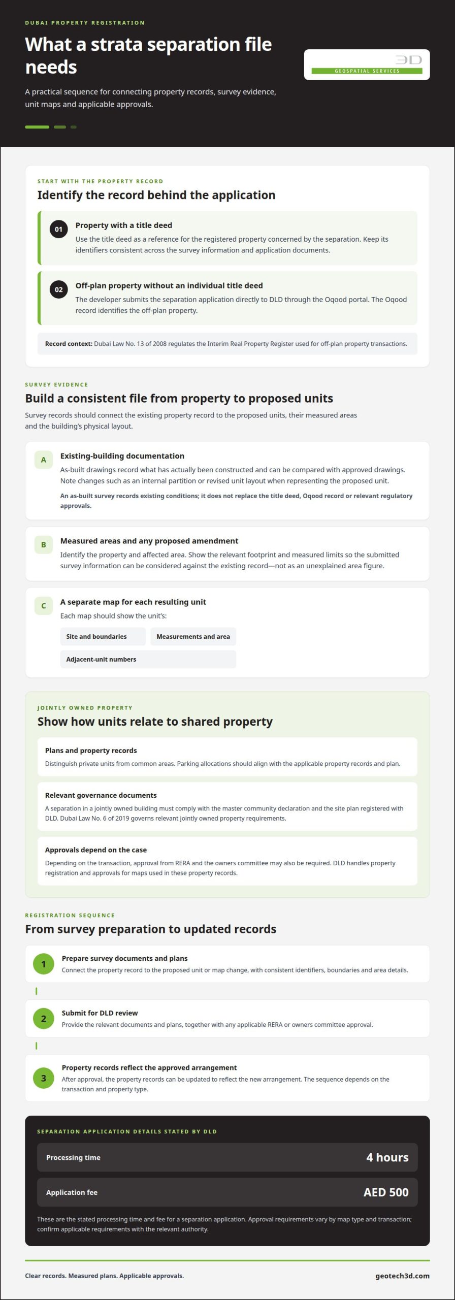
A separation file connects the existing property record to the proposed units and their measured areas. The required documents depend on whether the property has a title deed or remains off-plan.
Title Deed and Oqood Survey Records
A title deed or Oqood record identifies the registered property that the separation application concerns. It gives the survey documentation a clear reference point and helps distinguish a completed property from an off-plan unit. Dubai Law No. 13 of 2008 regulates the Interim Real Property Register used for off-plan property transactions, according to Dubai Legislation Portal. For an off-plan property without an individual title deed, the developer submits the separation application directly to DLD through the Oqood portal.
Survey Submission Support
Survey submission support brings the property record, survey information and separation documents into a coordinated application. The survey records the property’s components, physical characteristics and areas, while the application connects those details to the registered property. DLD’s stated processing time for a separation application is four hours, and its application fee is AED 500. Clear, consistent information helps keep the submitted record aligned with the property being separated.
As-Built Drawings and Existing-Building Documentation
For an existing building, as-built drawings record what has actually been constructed and can be compared with approved drawings. This helps identify differences between the approved layout and current conditions before separation information is prepared. A changed internal partition or revised unit layout, for example, may affect how a proposed unit is represented. An as-built survey records existing conditions; it does not replace the title deed, Oqood record or relevant regulatory approvals.
Documents for Amending Land Area
An area amendment needs survey information that explains the recorded area and the measured condition being submitted. Supporting documents should identify the property and affected area clearly so the proposed amendment can be considered against the existing record. A boundary or building measurement may reveal a difference between the recorded and observed area. The survey should identify the relevant footprint and measured limits, rather than presenting the change as an unexplained figure.
For a separation, each resulting unit needs its own map showing its site, boundaries, measurements, area and adjacent-unit numbers. These maps connect the survey evidence to the proposed registration records. The survey provider should meet the DLD requirements for the relevant service, and submission support should keep property identifiers and survey details consistent across the application documents. This gives reviewers a defined record of each proposed unit and its relationship to the original property.
Maps and approvals for jointly owned properties
For jointly owned property, registration depends on clear plans and approvals relevant to its ownership structure. The required map and approval route vary depending on whether the transaction concerns a unit, shared areas or a change to existing property data.
Rules Governing Strata Plans
Dubai Law No. 6 of 2019 governs jointly owned property requirements relevant to property separation. A separation in a jointly owned building must comply with the master community declaration and the site plan registered with DLD. These records provide the regulatory framework for assessing how proposed units relate to shared property. Depending on the case, approval from RERA and the owners committee may also be required.
Unit, Common-Area, and Parking Details
A strata plan and supporting maps show how individual units relate to the building and its shared areas. Each resulting unit needs a map showing its site, boundaries, measurements, area and adjacent-unit numbers. Parking allocations should align with the applicable property records and plan. Clearly distinguishing private units from common areas helps avoid ambiguity in the registration record.
Authority Approvals and Registration
DLD handles property registration and approvals for maps used in these property records. RERA and the owners committee may also be involved when a unit separation in a jointly owned building requires their approval. Survey documents submitted to DLD should meet the requirements for the relevant service. A survey provider prepares the supporting information; the appropriate authorities and governance bodies handle their respective approvals.
Survey Submission and Approval Steps
The registration process generally links existing property records, survey plans, required approvals and the application for updated registration. First, prepare survey documents for the proposed unit or map change. Then submit the relevant documents and plans for DLD review, together with any applicable RERA or owners committee approval. After approval, the property records can reflect the new arrangement. The sequence depends on the transaction and property type.
Approval requirements depend on the specific map type and transaction. Confirm applicable requirements with the relevant authority before submitting an application.
Errors such as mismatched unit identifiers, boundaries, or common-area details can lead to review questions and revisions, delaying the registration process. A coordinated submission helps keep maps and property records aligned. For survey support that relates to property layouts and registration documentation, explore real estate strata services.
Property area measurement and verification
Property area is central to the real estate record because it connects a unit’s documented dimensions to its physical form. The Dubai Land Department publishes guidelines on property measurement and registration standards that surveys must align with. Verification should therefore establish which area is being recorded, what property component it describes and how the measurement relates to the submitted plan.
Begin by defining the area under review. A unit, building footprint and shared space represent different parts of a property, so the measurement record should identify the relevant component. For example, an individual unit’s area should not be confused with a common corridor shown elsewhere on the plan. Clear labels connect each figure to its location and purpose.
Next, document physical conditions and compare them with the drawings used for the property record. A survey can capture the observed layout and relevant dimensions, then show how they relate to the available plan. This comparison can reveal an altered wall line, a changed room arrangement or a boundary that does not align with the drawing. Describe the discrepancy rather than concealing it in a revised total.
Verification also depends on consistent references. The property identifier, unit label, plan reference and measured area should correspond across the survey record and supporting documents. If a drawing labels a unit differently from the associated record, reviewers may struggle to connect the measurement to the intended property. A structured check can compare:
- Property reference: Does the survey identify the same property or unit as the registration document?
- Plan boundaries: Do the measured limits correspond with the area outlined on the drawing?
- Component labels: Are individual units and shared spaces identified distinctly?
- Recorded area: Is the reported figure associated with the correct component and plan?
When a mismatch appears, the survey documents should make its location and nature clear. For example, a measurement difference near a unit boundary should be distinguished from a change within the unit’s internal layout. This helps explain whether the issue concerns the physical configuration, the plan representation or the relationship between them. It also gives the registration file a clear basis for review.
For a Dubai property registration submission, present final survey information in a coordinated form, with legible plans and consistent identifiers. The Dubai Land Department’s measurement and registration guidelines provide the relevant framework. Applying that framework to each measured component helps make the property record coherent and supports informed review of area information.
Choosing a property survey provider
For a Dubai property registration project, the survey provider’s work must match the specific DLD service and property conditions. The scope may differ for a newly completed building, an existing unit or a separation within jointly owned property. Define the registration purpose first, then align the survey deliverables with the records and drawings required for that transaction.
DLD requirements matter because survey documents submitted for a service should meet that service’s requirements. A provider’s scope should identify the property, survey purpose, expected drawings, area information and submission support. A unit separation, for example, needs information organised around the proposed units, while an existing-building review may need an as-built record showing actual conditions.
Choose a technical approach suited to the site and information required. An as-built survey records what has been constructed and can compare existing conditions with approved drawings. At handover, this comparison can document differences between the approved layout and the completed building. For an occupied property, the scope may instead focus on recording existing unit boundaries and relevant shared spaces.
Review the proposed deliverables as a coordinated package, not as isolated drawings. A useful scope explains how survey plans, measured areas, property identifiers and supporting documents relate to one another. For example, a unit label on a drawing should match the unit in the registration documents. This coordination keeps the survey record clear during review and any later amendment.
Timing is another scope factor. Survey timelines in Dubai can vary with property size, complexity and the authority involved. A straightforward unit survey and a survey involving complex building geometry have different site and drafting requirements. Developers planning completion or handover should include survey work in the wider registration sequence, rather than treating it as a separate final task.
During provider evaluation, structure the decision around the work required:
- Purpose: Identify whether the survey supports first registration, separation, an area amendment, or an existing-condition record.
- Site conditions: Clarify whether the property is completed, occupied, under construction, or being prepared for handover.
- Outputs: Define the plans, measurements, and supporting documents needed for the relevant DLD service.
- Coordination: Establish how drawing labels and property references will remain consistent across deliverables.
A survey company’s value lies in producing information that serves the stated registration purpose and accurately reflects physical conditions. For developers, aligning the scope with completion milestones can reduce clashes between surveying, drawing updates and document preparation. For an existing property, clear boundaries and area records help distinguish a unit from adjacent spaces. In either case, a defined scope provides a more usable technical record for registration.
Survey plans and property registration support for DLD
Survey plans connect measured property information with the records used in Dubai registration workflows. Dubai Land Department manages property registration and related real estate records. Dubai Law No. 7 of 2006 requires divisions and mergers of real property units to be recorded in the Property Register, according to Dubai Legislation Portal. The key takeaway is that a survey plan supports registration by describing the property configuration clearly, while DLD maintains the relevant official record.
The registration route depends on the transaction. Dubai processes can involve title deed registration, Oqood registration, Ejari registration, component or volume registration, common-area updates and master community registration. Each record serves a different purpose. A plan for a unit separation, for example, describes the proposed units, while a common-area update concerns shared property information. Identifying the applicable process helps align drawings and survey details with the record being changed.
For off-plan property, Oqood documentation is central to the interim registration route. Dubai Law No. 13 of 2008 regulates the Interim Real Property Register used for off-plan property transactions. Developers must complete Oqood registration, including an approved survey report, before marketing or selling an off-plan unit. This makes the survey report part of the registration support chain, rather than an optional illustration for investors reviewing ownership information.
Organise a coordinated submission around the transaction’s purpose:
- Identify the record: Establish whether the application concerns a title deed, Oqood entry, unit division, common-area update, or another registration process.
- Prepare supporting drawings: Present the relevant unit, boundaries, areas, and shared components in a plan suited to that record.
- Align identifiers: Keep unit labels and property references consistent across the survey plan and supporting documents.
- Submit for the relevant review: Provide the survey information through the applicable DLD process, including the approved survey report for off-plan Oqood registration.
These steps connect physical conditions to official property information. An investor assessing a proposed unit, for example, needs drawings that distinguish it from shared components. A separation or merger instead requires the changed configuration to appear in the Property Register. Survey plans support the transaction by making the recorded arrangement clear, while the legal record remains the basis for registered ownership. Clear links between plans, identifiers and application purpose make the supporting information more useful during review.
GEOTECH 3D: topo survey
GEOTECH 3D can support property projects through topo survey and real estate strata services. A topo survey records physical site features and elevations, such as ground levels, existing structures, roads, and access points. This information can help establish site context alongside building and unit survey records.
For a property registration project, real estate strata support is relevant when survey documentation needs to describe units and their relationship to shared property. The appropriate scope depends on the property and the registration task. Where existing building conditions also need detailed capture, 3D Laser Scanning may support the survey workflow.
Move your property record forward with confidence
Use the next project milestone to align the survey scope with the property’s registration needs. A strata plan survey for property registration in Dubai can be part of that planning, alongside relevant site and building information. Coordinating surveying with project documents gives stakeholders a practical basis for moving the work forward.
GEOTECH 3D offers topo survey, 3D Laser Scanning and Drone Services. The appropriate approach depends on the property, the information required and the intended use of the survey. Bringing those requirements into the project discussion early can help establish a suitable scope for your Dubai property.
A defined next step helps your team move forward with clarity and keep the property record aligned with project needs.
Frequently Asked Questions
How can properties be registered in Dubai?
Start by identifying the transaction, such as a purchase, separation or merger, because each affects a different property record. For a separation, an existing mortgage adds an important consideration: the financing bank’s no-objection certificate is required. Registered rights against the original unit remain relevant after separation, so the application should account for them rather than treating the new units as unencumbered.
What Does a Real Estate Survey Company in Dubai Do?
A real estate survey company captures and organises spatial information for land and buildings. The right survey depends on the intended use: a topo survey can record ground levels, contours, roads, structures, and access points, while 3D laser scanning captures building conditions. These outputs support different project needs, from understanding site context to documenting a building’s physical form for technical coordination.
What Is DLD Registration and How Does Surveying Support It?
DLD records property information through Dubai’s official land and real estate system. Surveying provides spatial evidence, but does not itself register ownership. For example, separating a mortgaged unit requires the financing bank’s no-objection certificate, and registered rights remain relevant to the resulting units. This distinction helps owners and investors understand why survey documents and ownership records serve separate purposes.
What are the maps approved by Dubai Land Department?
DLD map services include land plot maps and unified land maps with Dubai Municipality, as well as property and building maps. A land plot map outside Dubai Municipality jurisdiction is listed at AED 100, while a unified land map with Dubai Municipality is listed at AED 225. These are map service charges, not a survey-service price, and the applicable map depends on the land record and jurisdiction.
What is a strata plan survey for property registration in Dubai?
A strata plan survey is a survey-based spatial record representing the proposed strata arrangement for property documentation. Its practical value is showing how the scheme is organised, rather than providing only a general building plan. For a project team, this connects the intended property structure to the drawings and records used in the registration process, while keeping survey evidence distinct from the legal act of registration.
What documents are required for a Dubai strata plan survey?
The required file depends on the property’s registration status and the change being sought. Also consider whether the original unit has a registered mortgage. If so, separation requires a no-objection certificate from the financing bank, and existing registered rights remain relevant. Including this in document planning helps ensure the survey file is not treated as the only requirement.
Who is qualified to conduct strata plan surveys in Dubai?
The survey provider must meet the requirements for the relevant DLD service. The technical scope should also suit the property: documenting land context differs from recording detailed building conditions. A surveyor preparing strata information needs to represent the proposed property arrangement clearly and produce documents suited to their registration purpose. Survey preparation and official approval are separate parts of the process.
How much does a strata plan survey and registration cost in Dubai?
Survey work and registration do not have a single combined cost. The survey-service price is scoped to the project, while DLD charges relate to specific applications or map services. For example, published land-map charges differ by map type and jurisdiction. Treating these as separate cost categories helps avoid mistaking an authority fee for the survey price.

A property registration is only as clear as the record behind it. In Dubai, a strata plan survey for property registration in Dubai can document unit boundaries, areas and shared components to support the registration record. The Dubai Land Department handles property registration, and Dubai Law No. 7 of 2006 requires divisions and mergers of real property units to be recorded in the Property Register, according to Dubai Legislation Portal.
When preparing a strata plan survey for property registration in Dubai, the plans and area information matter as much as the application. Clear survey documentation shows how individual units relate to the building and its common areas.
This guide explains which documents, maps and approvals may support registration, and how area checks help align survey information with the property’s physical layout. Requirements can differ for a new registration, a property separation or an update to existing records, so it helps to understand the steps before an application proceeds.
Key Takeaways
- Understand which property records and survey details can support a separation application, including when off-plan registration follows a different process.
- See how unit maps, shared areas and applicable approvals contribute to clear records for jointly owned properties.
- Learn why measured areas should be compared with the property’s physical layout and relevant plans.
- Identify what to consider when selecting survey support, including alignment with the requirements of the relevant DLD service.
- Explore how survey plans and real estate strata services can support property registration workflows in Dubai.
Documents required for a property separation application
A separation file connects the existing property record to the proposed units and their measured areas. The required documents depend on whether the property has a title deed or remains off-plan.
Title Deed and Oqood Survey Records
A title deed or Oqood record identifies the registered property that the separation application concerns. It gives the survey documentation a clear reference point and helps distinguish a completed property from an off-plan unit. Dubai Law No. 13 of 2008 regulates the Interim Real Property Register used for off-plan property transactions, according to Dubai Legislation Portal. For an off-plan property without an individual title deed, the developer submits the separation application directly to DLD through the Oqood portal.
Survey Submission Support
Survey submission support brings the property record, survey information and separation documents into a coordinated application. The survey records the property’s components, physical characteristics and areas, while the application connects those details to the registered property. DLD’s stated processing time for a separation application is four hours, and its application fee is AED 500. Clear, consistent information helps keep the submitted record aligned with the property being separated.
As-Built Drawings and Existing-Building Documentation
For an existing building, as-built drawings record what has actually been constructed and can be compared with approved drawings. This helps identify differences between the approved layout and current conditions before separation information is prepared. A changed internal partition or revised unit layout, for example, may affect how a proposed unit is represented. An as-built survey records existing conditions; it does not replace the title deed, Oqood record or relevant regulatory approvals.
Documents for Amending Land Area
An area amendment needs survey information that explains the recorded area and the measured condition being submitted. Supporting documents should identify the property and affected area clearly so the proposed amendment can be considered against the existing record. A boundary or building measurement may reveal a difference between the recorded and observed area. The survey should identify the relevant footprint and measured limits, rather than presenting the change as an unexplained figure.
For a separation, each resulting unit needs its own map showing its site, boundaries, measurements, area and adjacent-unit numbers. These maps connect the survey evidence to the proposed registration records. The survey provider should meet the DLD requirements for the relevant service, and submission support should keep property identifiers and survey details consistent across the application documents. This gives reviewers a defined record of each proposed unit and its relationship to the original property.
Maps and approvals for jointly owned properties
For jointly owned property, registration depends on clear plans and approvals relevant to its ownership structure. The required map and approval route vary depending on whether the transaction concerns a unit, shared areas or a change to existing property data.
Rules Governing Strata Plans
Dubai Law No. 6 of 2019 governs jointly owned property requirements relevant to property separation. A separation in a jointly owned building must comply with the master community declaration and the site plan registered with DLD. These records provide the regulatory framework for assessing how proposed units relate to shared property. Depending on the case, approval from RERA and the owners committee may also be required.
Unit, Common-Area, and Parking Details
A strata plan and supporting maps show how individual units relate to the building and its shared areas. Each resulting unit needs a map showing its site, boundaries, measurements, area and adjacent-unit numbers. Parking allocations should align with the applicable property records and plan. Clearly distinguishing private units from common areas helps avoid ambiguity in the registration record.
Authority Approvals and Registration
DLD handles property registration and approvals for maps used in these property records. RERA and the owners committee may also be involved when a unit separation in a jointly owned building requires their approval. Survey documents submitted to DLD should meet the requirements for the relevant service. A survey provider prepares the supporting information; the appropriate authorities and governance bodies handle their respective approvals.
Survey Submission and Approval Steps
The registration process generally links existing property records, survey plans, required approvals and the application for updated registration. First, prepare survey documents for the proposed unit or map change. Then submit the relevant documents and plans for DLD review, together with any applicable RERA or owners committee approval. After approval, the property records can reflect the new arrangement. The sequence depends on the transaction and property type.
Approval requirements depend on the specific map type and transaction. Confirm applicable requirements with the relevant authority before submitting an application.
Errors such as mismatched unit identifiers, boundaries, or common-area details can lead to review questions and revisions, delaying the registration process. A coordinated submission helps keep maps and property records aligned. For survey support that relates to property layouts and registration documentation, explore real estate strata services.
Property area measurement and verification
Property area is central to the real estate record because it connects a unit’s documented dimensions to its physical form. The Dubai Land Department publishes guidelines on property measurement and registration standards that surveys must align with. Verification should therefore establish which area is being recorded, what property component it describes and how the measurement relates to the submitted plan.
Begin by defining the area under review. A unit, building footprint and shared space represent different parts of a property, so the measurement record should identify the relevant component. For example, an individual unit’s area should not be confused with a common corridor shown elsewhere on the plan. Clear labels connect each figure to its location and purpose.
Next, document physical conditions and compare them with the drawings used for the property record. A survey can capture the observed layout and relevant dimensions, then show how they relate to the available plan. This comparison can reveal an altered wall line, a changed room arrangement or a boundary that does not align with the drawing. Describe the discrepancy rather than concealing it in a revised total.
Verification also depends on consistent references. The property identifier, unit label, plan reference and measured area should correspond across the survey record and supporting documents. If a drawing labels a unit differently from the associated record, reviewers may struggle to connect the measurement to the intended property. A structured check can compare:
- Property reference: Does the survey identify the same property or unit as the registration document?
- Plan boundaries: Do the measured limits correspond with the area outlined on the drawing?
- Component labels: Are individual units and shared spaces identified distinctly?
- Recorded area: Is the reported figure associated with the correct component and plan?
When a mismatch appears, the survey documents should make its location and nature clear. For example, a measurement difference near a unit boundary should be distinguished from a change within the unit’s internal layout. This helps explain whether the issue concerns the physical configuration, the plan representation or the relationship between them. It also gives the registration file a clear basis for review.
For a Dubai property registration submission, present final survey information in a coordinated form, with legible plans and consistent identifiers. The Dubai Land Department’s measurement and registration guidelines provide the relevant framework. Applying that framework to each measured component helps make the property record coherent and supports informed review of area information.
Choosing a property survey provider
For a Dubai property registration project, the survey provider’s work must match the specific DLD service and property conditions. The scope may differ for a newly completed building, an existing unit or a separation within jointly owned property. Define the registration purpose first, then align the survey deliverables with the records and drawings required for that transaction.
DLD requirements matter because survey documents submitted for a service should meet that service’s requirements. A provider’s scope should identify the property, survey purpose, expected drawings, area information and submission support. A unit separation, for example, needs information organised around the proposed units, while an existing-building review may need an as-built record showing actual conditions.
Choose a technical approach suited to the site and information required. An as-built survey records what has been constructed and can compare existing conditions with approved drawings. At handover, this comparison can document differences between the approved layout and the completed building. For an occupied property, the scope may instead focus on recording existing unit boundaries and relevant shared spaces.
Review the proposed deliverables as a coordinated package, not as isolated drawings. A useful scope explains how survey plans, measured areas, property identifiers and supporting documents relate to one another. For example, a unit label on a drawing should match the unit in the registration documents. This coordination keeps the survey record clear during review and any later amendment.
Timing is another scope factor. Survey timelines in Dubai can vary with property size, complexity and the authority involved. A straightforward unit survey and a survey involving complex building geometry have different site and drafting requirements. Developers planning completion or handover should include survey work in the wider registration sequence, rather than treating it as a separate final task.
During provider evaluation, structure the decision around the work required:
- Purpose: Identify whether the survey supports first registration, separation, an area amendment, or an existing-condition record.
- Site conditions: Clarify whether the property is completed, occupied, under construction, or being prepared for handover.
- Outputs: Define the plans, measurements, and supporting documents needed for the relevant DLD service.
- Coordination: Establish how drawing labels and property references will remain consistent across deliverables.
A survey company’s value lies in producing information that serves the stated registration purpose and accurately reflects physical conditions. For developers, aligning the scope with completion milestones can reduce clashes between surveying, drawing updates and document preparation. For an existing property, clear boundaries and area records help distinguish a unit from adjacent spaces. In either case, a defined scope provides a more usable technical record for registration.
Survey plans and property registration support for DLD
Survey plans connect measured property information with the records used in Dubai registration workflows. Dubai Land Department manages property registration and related real estate records. Dubai Law No. 7 of 2006 requires divisions and mergers of real property units to be recorded in the Property Register, according to Dubai Legislation Portal. The key takeaway is that a survey plan supports registration by describing the property configuration clearly, while DLD maintains the relevant official record.
The registration route depends on the transaction. Dubai processes can involve title deed registration, Oqood registration, Ejari registration, component or volume registration, common-area updates and master community registration. Each record serves a different purpose. A plan for a unit separation, for example, describes the proposed units, while a common-area update concerns shared property information. Identifying the applicable process helps align drawings and survey details with the record being changed.
For off-plan property, Oqood documentation is central to the interim registration route. Dubai Law No. 13 of 2008 regulates the Interim Real Property Register used for off-plan property transactions. Developers must complete Oqood registration, including an approved survey report, before marketing or selling an off-plan unit. This makes the survey report part of the registration support chain, rather than an optional illustration for investors reviewing ownership information.
Organise a coordinated submission around the transaction’s purpose:
- Identify the record: Establish whether the application concerns a title deed, Oqood entry, unit division, common-area update, or another registration process.
- Prepare supporting drawings: Present the relevant unit, boundaries, areas, and shared components in a plan suited to that record.
- Align identifiers: Keep unit labels and property references consistent across the survey plan and supporting documents.
- Submit for the relevant review: Provide the survey information through the applicable DLD process, including the approved survey report for off-plan Oqood registration.
These steps connect physical conditions to official property information. An investor assessing a proposed unit, for example, needs drawings that distinguish it from shared components. A separation or merger instead requires the changed configuration to appear in the Property Register. Survey plans support the transaction by making the recorded arrangement clear, while the legal record remains the basis for registered ownership. Clear links between plans, identifiers and application purpose make the supporting information more useful during review.
GEOTECH 3D: topo survey
GEOTECH 3D can support property projects through topo survey and real estate strata services. A topo survey records physical site features and elevations, such as ground levels, existing structures, roads, and access points. This information can help establish site context alongside building and unit survey records.
For a property registration project, real estate strata support is relevant when survey documentation needs to describe units and their relationship to shared property. The appropriate scope depends on the property and the registration task. Where existing building conditions also need detailed capture, 3D Laser Scanning may support the survey workflow.
Move your property record forward with confidence
Use the next project milestone to align the survey scope with the property’s registration needs. A strata plan survey for property registration in Dubai can be part of that planning, alongside relevant site and building information. Coordinating surveying with project documents gives stakeholders a practical basis for moving the work forward.
GEOTECH 3D offers topo survey, 3D Laser Scanning and Drone Services. The appropriate approach depends on the property, the information required and the intended use of the survey. Bringing those requirements into the project discussion early can help establish a suitable scope for your Dubai property.
A defined next step helps your team move forward with clarity and keep the property record aligned with project needs.
Frequently Asked Questions
How can properties be registered in Dubai?
Start by identifying the transaction, such as a purchase, separation or merger, because each affects a different property record. For a separation, an existing mortgage adds an important consideration: the financing bank’s no-objection certificate is required. Registered rights against the original unit remain relevant after separation, so the application should account for them rather than treating the new units as unencumbered.
What Does a Real Estate Survey Company in Dubai Do?
A real estate survey company captures and organises spatial information for land and buildings. The right survey depends on the intended use: a topo survey can record ground levels, contours, roads, structures, and access points, while 3D laser scanning captures building conditions. These outputs support different project needs, from understanding site context to documenting a building’s physical form for technical coordination.
What Is DLD Registration and How Does Surveying Support It?
DLD records property information through Dubai’s official land and real estate system. Surveying provides spatial evidence, but does not itself register ownership. For example, separating a mortgaged unit requires the financing bank’s no-objection certificate, and registered rights remain relevant to the resulting units. This distinction helps owners and investors understand why survey documents and ownership records serve separate purposes.
What are the maps approved by Dubai Land Department?
DLD map services include land plot maps and unified land maps with Dubai Municipality, as well as property and building maps. A land plot map outside Dubai Municipality jurisdiction is listed at AED 100, while a unified land map with Dubai Municipality is listed at AED 225. These are map service charges, not a survey-service price, and the applicable map depends on the land record and jurisdiction.
What is a strata plan survey for property registration in Dubai?
A strata plan survey is a survey-based spatial record representing the proposed strata arrangement for property documentation. Its practical value is showing how the scheme is organised, rather than providing only a general building plan. For a project team, this connects the intended property structure to the drawings and records used in the registration process, while keeping survey evidence distinct from the legal act of registration.
What documents are required for a Dubai strata plan survey?
The required file depends on the property’s registration status and the change being sought. Also consider whether the original unit has a registered mortgage. If so, separation requires a no-objection certificate from the financing bank, and existing registered rights remain relevant. Including this in document planning helps ensure the survey file is not treated as the only requirement.
Who is qualified to conduct strata plan surveys in Dubai?
The survey provider must meet the requirements for the relevant DLD service. The technical scope should also suit the property: documenting land context differs from recording detailed building conditions. A surveyor preparing strata information needs to represent the proposed property arrangement clearly and produce documents suited to their registration purpose. Survey preparation and official approval are separate parts of the process.
How much does a strata plan survey and registration cost in Dubai?
Survey work and registration do not have a single combined cost. The survey-service price is scoped to the project, while DLD charges relate to specific applications or map services. For example, published land-map charges differ by map type and jurisdiction. Treating these as separate cost categories helps avoid mistaking an authority fee for the survey price.
Search Now
Error: Contact form not found.