

Our Services
Survey Accuracy Standards in UAE: Positioning and Compliance
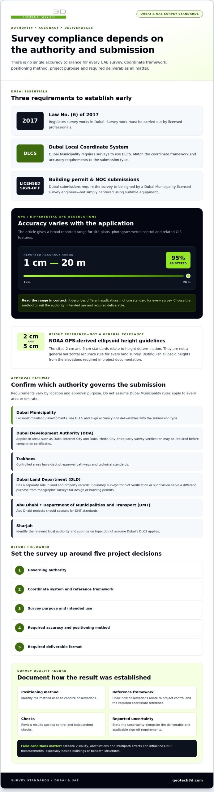
Precision alone doesn’t make a survey compliant. For survey accuracy standards in UAE projects, the applicable requirements depend on the authority and submission type. In Dubai, surveys must use the Dubai Local Coordinate System (DLCS), Dubai Municipality sets different accuracy standards for different submissions, and survey work must be carried out by licensed professionals under Law No. (6) of 2017.
It’s understandable to look for one figure that defines a reliable survey. In practice, positioning method, control points, project purpose, and required deliverables all affect whether the data is fit for use.
This article explains how requirements in Dubai and Abu Dhabi shape survey quality, what GNSS positioning contributes, and why licensing and clear deliverables matter. It also shows how authority requirements relate to design, construction, and submission reviews.
Key Takeaways
- Dubai surveys must use the Dubai Local Coordinate System, and accuracy requirements vary by submission type.
- GNSS positioning accuracy depends on the method and project purpose, so choose an approach that fits the required deliverable.
- For Dubai building permit and NOC submissions, surveys must be signed by a Dubai Municipality-licensed survey engineer.
- Abu Dhabi projects have DMT standards to consider, while outdated survey data can contribute to conflicts and resubmissions.
- A topo survey can document existing site conditions to support informed design and planning.
Dubai Municipality coordinate system and survey requirements
In Dubai, Law No. (6) of 2017 regulates survey works, while Dubai Municipality sets technical requirements for different survey submissions. The applicable accuracy standard depends on the submission type, so there is no single tolerance for every land survey. Dubai Municipality requires surveys to use the Dubai Local Coordinate System (DLCS), supporting consistent coordinates across project data and authority reviews.
Dubai Municipality is the primary authority for most mainland developments. Survey work must be carried out by licensed professionals, and building permit and NOC submissions in Dubai require surveys signed by a Dubai Municipality-licensed survey engineer. This applies to formal submissions, not just the equipment used to capture measurements. GNSS or total station observations must also relate correctly to the required coordinate framework.
Start by identifying the project location and intended approval. Dubai Municipality requirements generally apply to mainland projects, while designated areas can follow separate pathways. Dubai Development Authority (DDA) jurisdiction applies in areas such as Dubai Internet City and Dubai Media City. Trakhees-controlled areas also have distinct approval pathways and technical standards. Identifying the governing authority early helps teams prepare the right submission and avoid preventable delays.
- Dubai Municipality: Use DLCS and match the survey’s accuracy and deliverables to the submission type.
- DDA: Account for its jurisdiction and potential third-party survey verification before completion certificates.
- Trakhees: Follow the technical standards and approval pathway applicable to its controlled areas.
Dubai Land Department (DLD) has a separate role in land and property records. Dubai Land Department regulations govern land surveys in Dubai. A boundary survey for plot verification or subdivision therefore serves a different approval purpose from a topographic survey for design or building permits. Distinguish land-record requirements from technical submission requirements.
Across the UAE, requirements are emirate- and authority-specific. Abu Dhabi projects should account for Department of Municipalities and Transport (DMT) standards. In Sharjah, identify the relevant local authority and submission type before setting survey tolerances; Dubai’s DLCS should not be assumed to apply. For the question of governing rules, Dubai relies on Law No. (6) of 2017 and Dubai Municipality’s technical submission requirements. Abu Dhabi projects must consider DMT standards, while Sharjah requirements depend on the applicable authority and approval pathway.
Before fieldwork, record the governing authority, coordinate system, survey purpose, required accuracy, and deliverable format. For example, a topographic submission for a Dubai mainland building permit must align with applicable Dubai Municipality requirements and DLCS. A project in a DDA or Trakhees area needs to follow its relevant approval pathway. This distinction keeps field data, drawings, and submissions aligned.
GPS/GNSS positioning accuracy
GPS and GNSS measurements use signals from satellite constellations to locate survey points. Accuracy depends on the positioning method, observation conditions, control, and project purpose. A standalone position is not equivalent to a corrected GNSS observation. For a boundary survey, a positional difference can affect plot dimensions. For a broad GIS feature, a different accuracy may suit the intended mapping scale.
GPS or differential GPS observations can support site plans, photogrammetric control, and related GIS features at accuracies from 1 cm to 20 meters (95%). This wide range describes different applications, not one standard for every UAE survey. A project team must match the method to the required deliverable. Residential plot documentation, for example, has different demands from regional mapping or preliminary site context.
GNSS workflows can use corrections and control references to improve positional consistency. The Dubai GNSS/RTK survey guide covers the UAE National Control Network. Surveyors should consider how observations relate to project control and the coordinate reference, then review results against independent checks. Satellite visibility, obstructions, and multipath effects can influence measurements, especially beside buildings or beneath structures.
There is no universal accuracy figure for every land and topographic survey in the UAE. Requirements depend on the authority, submission type, and intended use. Dubai Municipality sets different standards for different submission types.
Measurement quality is assessed through control checks and comparisons between observed and known positions. Documentation should identify the positioning method, reference framework, checks, and reported uncertainty. Formal signoff follows the applicable submission requirements.
Height measurements need particular care. NOAA guidelines for GPS-derived ellipsoid heights cite 2 cm and 5 cm standards. These values relate to height determination, not a general horizontal accuracy rule for every land survey. A survey team must distinguish ellipsoid heights from the elevation values required in project documentation. Mixing height references can create inconsistencies between design levels, site observations, and handover records.
Relative accuracy describes how well measured points relate to one another. Absolute accuracy describes how closely positions relate to the reference framework. A boundary survey may need dependable plot corners, while an as-built survey may record constructed features against design information. These purposes shape the control strategy and checks.
When reviewing survey services, read the accuracy statement alongside the deliverable. Check that the coordinate reference, units, observation method, control checks, and stated uncertainty are clear. For GNSS-based mapping, this information helps engineers judge whether the data supports design, construction coordination, or handover, without mistaking a broad positioning range for a project-specific tolerance.
Surveyor licensing and compliant deliverables
In Dubai, a survey’s technical quality and formal acceptance are connected but distinct. Law No. (6) of 2017 regulates survey works, and survey work must be carried out by licensed professionals. For building permit and NOC submissions, only surveys signed by a Dubai Municipality-licensed survey engineer are accepted. A precisely measured file can still fail its submission purpose if it lacks the required professional signoff.
Plan deliverables around the project decision. A topographic survey for engineering design should let the design team interpret existing site conditions and reference positions consistently. A boundary survey serves a different purpose: recording plot limits and dimensions. For a permit submission, clarify the survey purpose, coordinate reference, and authority pathway before finalizing drawings.
A useful survey package makes the link between field observations and submitted drawings clear. Include the coordinate reference, control information, survey scope, and data capture method. If GNSS observations support the work, document how positions relate to project control. If a total station is used for building corners or foundation setting-out, connect those measurements to the stated reference framework. These details help reviewers and engineers interpret the survey.
Before submission, check the drawing and supporting data for consistency. Confirm, for example, that plotted boundary points match the coordinate schedule, units are consistent, and labels identify the intended features. A topographic survey should distinguish measured site features from design information. For engineering coordination, show levels and reference points clearly so teams don’t mistake proposed foundation locations for observed site conditions.
- Professional signoff: Confirm the responsible survey engineer’s Dubai Municipality licensing applies to the submission.
- Reference: State the coordinate framework and control information used for the survey.
- Purpose: Identify whether the work supports a boundary check, topographic design, permit, or construction activity.
- Consistency: Compare the drawing, coordinate schedule, and supporting data before submission.
Dubai Municipality sets different accuracy standards for different survey submission types, so defining the scope is essential. Acceptance criteria for a topographic submission may differ from those for another authority purpose. Tie the accuracy statement to the intended use rather than presenting one tolerance as universal. For a building permit or NOC, a licensed engineer’s signature is also an acceptance requirement.
Compliant documentation supports review, coordination, and later project stages. When engineers check a foundation layout against a survey reference, they can interpret site positions alongside approved drawings. If plot information is used for property records, keep the boundary survey’s purpose distinct from construction layout. Clear scope and signoff help the receiving authority understand the survey’s role without confusing design data with measured conditions.
Abu Dhabi Department of Municipalities and Transport standards
Abu Dhabi projects follow a different authority framework from Dubai submissions. The Department of Municipalities and Transport (DMT) sets standards relevant to municipal project approvals. Surveyors familiar with DMT requirements can help align deliverables with submission needs. Identify the approving authority and intended survey use before choosing measurement methods or preparing mapping outputs.
Assess accuracy against the task, not as an isolated figure. A construction layout survey marks structural positions and elevations according to approved drawings. A topographic survey records existing site conditions for design coordination. A boundary survey addresses plot limits and dimensions. These outputs support different decisions in commercial development, so one survey tolerance cannot represent every project requirement.
Relative accuracy can be expressed as a closure ratio. A survey closure ratio of 1:10,000 is one example of how relative accuracy may be described. First-Order surveys are identified with relative line accuracy of 1:100,000. These are technical reference examples, not universal DMT acceptance thresholds. Fourth-Order accuracy is identified for construction layout grading work, illustrating how survey class relates to intended use.
For an Abu Dhabi submission, connect each measurement to its purpose and supporting reference. Review whether control points, coordinates, levels, and drawing information agree. If layout data guides structural positioning, compare measured positions with approved drawings. If mapping supports site design, distinguish recorded features from proposed works. This makes the deliverable easier for developers, engineers, and authority reviewers to interpret.
- Project location: Identify the Abu Dhabi jurisdiction and approving authority.
- Survey purpose: Separate boundary, topographic, and construction layout requirements.
- Accuracy description: State the method and relative accuracy expression used.
- Deliverable review: Compare coordinates, levels, control references, and drawings.
These checks also support monitoring as work progresses. Construction layout measurements can be compared with approved design positions, while as-built documentation records completed conditions. Clear reference information helps teams determine whether differences reflect design changes, field conditions, or measurement results. That distinction matters on commercial projects, where several disciplines may rely on the same survey data.
Disputes can arise when parties interpret plot limits, site levels, or construction positions differently. In Abu Dhabi, organized survey documentation gives reviewers and project teams a common basis for examining discrepancies. Keep the survey purpose, coordinate framework, measurement method, and relevant checks with the deliverable. For boundary questions, distinguish recorded parcel information from construction layout observations.
Survey requirements vary by authority and submission purpose across the UAE. Dubai Municipality requirements are not interchangeable with DMT standards. For Abu Dhabi projects, plan with DMT requirements in mind and define the deliverable before fieldwork. This helps developers coordinate design, construction, and authority review using data prepared for its intended role.
Risks of inaccurate or incomplete surveying
Outdated survey data can lead to conflicts and resubmissions on Dubai projects. Site conditions and authority records may change after earlier measurements. If a design team relies on an old boundary or surface plan, the plotted information may no longer represent current conditions. Compare current field observations with existing project documentation to identify differences before design or submission work proceeds.
Assuming terrain rather than measuring it can affect grading and drainage design. Incorrect ground levels may cause mismatched slab and road levels, drainage failures, and increased basement-flooding risk. A topographic survey records elevations and visible site features, giving engineers measured information to assess terrain against planned works. Even a level difference overlooked on a drawing can affect site coordination.
Missing details can matter as much as incorrect measurements. If a survey omits structures, surface conditions, or utility indicators, designers may be working with an incomplete picture. On an industrial site, for example, unrecorded features can complicate layout planning and coordination with existing assets. A clear scope defines which site elements were measured and which are outside the survey record.
- Boundary information: Inconsistent plot dimensions can complicate planning and property discussions.
- Ground levels: Assumed terrain can contribute to grading errors and drainage problems.
- Site features: Missing structures or surface details can limit design coordination.
- Authority records: Outdated data can contribute to conflicts and resubmissions in Dubai.
Level documentation is required for authority submissions in Dubai and Abu Dhabi. Incomplete elevation information can leave reviewers without the data needed to assess a design. Before issuing a package, compare level labels, plotted points, and supporting records. For example, confirm that the drawing distinguishes measured ground levels from proposed slab or road levels.
Construction teams also rely on survey references to interpret site positions. If a layout drawing and field measurements use inconsistent references, crews may set out structures using information that does not align with the design. The licensed professional’s role and the documented basis of the deliverable matter, particularly for formal Dubai building permit and NOC submissions. Clear records help teams trace how reported positions relate to the survey.
To reduce these risks, review survey currency, scope, coordinate references, levels, and visible site features together. Treat discrepancies between a drawing and observed ground conditions as coordination issues to resolve before using the information for design or construction. This is especially important where existing structures, drainage paths, or changing site conditions affect proposed works.
GEOTECH 3D: topo survey
GEOTECH 3D provides topo surveys to document existing site conditions for planning and design. A survey can map ground elevations, structures, natural features, surface conditions, and utility indicators, creating a measured view of the site for project teams. In Dubai, topographic surveys are typically required before design and permit approval, making clear, relevant site information an important early project input.
Consider a topo survey when design decisions depend on current terrain, levels, or visible site features. The survey scope can be aligned with the project’s purpose and intended use of the data. GEOTECH 3D also provides 3D Laser Scanning, Drone Services, and GIS & Surveying Services for related geospatial requirements.
Contact GEOTECH 3D to discuss a topo survey for your project, or visit geotech3d.com.
Carry Survey Requirements into Your Next Project
Turn survey accuracy standards in UAE projects into a clear requirement, not an assumption. Before commissioning a survey, define how the data will be used, who will review it, and which decisions it must support. This gives your team a practical basis for aligning survey scope with design, construction, or asset planning.
Bring the relevant authority requirements and project objectives into the same discussion. A clear brief connects measurement needs with the deliverables engineers and project managers will use. It also supports purposeful coordination as project information moves from initial planning into later stages.
For a project-specific discussion about your survey requirements, contact GEOTECH 3D.
A well-planned start gives your team a stronger basis for informed decisions and steady project progress.
Frequently Asked Questions
What quality standards do you follow?
Survey quality should be measured against the project specification and the acceptance criteria for its intended use. GEOTECH 3D provides high-precision data acquisition and mapping solutions. In a project brief, define the required outputs, the checks used to review them, and how the information will support design, construction, or asset records. For example, a design team and an asset owner may need different information from the same site.
What positional accuracy tolerances are required for cadastral and boundary surveys in the UAE?
There is no single UAE-wide numeric tolerance for every cadastral or boundary survey. The relevant authority and intended cadastral use determine the applicable criteria. A useful specification distinguishes the accuracy of individual coordinates from the relative fit between boundary points. It should also state whether the output supports plot verification, subdivision, or another defined land-record purpose, rather than treating all boundary work as interchangeable.
What horizontal and vertical accuracy standards apply to engineering and construction surveys in the UAE?
Applicable tolerances depend on the authority, engineering task, and design stage. Horizontal accuracy concerns plan position, while vertical accuracy concerns elevation. Grading design, for example, depends on reliable level information; structural positioning depends on plan coordinates. State horizontal and vertical criteria separately in the project specification, then ensure reported results and review checks address both. This prevents a strong result in one dimension from concealing weaknesses in the other.
How do survey accuracy requirements differ between emirates such as Dubai and Abu Dhabi?
Requirements vary by emirate and approval pathway. Understanding survey accuracy standards in UAE projects means treating each authority submission as a separate technical brief. For work spanning Dubai and Abu Dhabi, a requirement matrix can record each location’s reference system, accuracy criteria, signoff needs, and file formats. This helps teams avoid carrying a template or assumption from one emirate to another without adapting it for the receiving authority.
What coordinate reference systems and geodetic datums must UAE surveys use?
Dubai surveys use the Dubai Local Coordinate System. Elsewhere in the UAE, follow the reference requirements of the local authority and project. Survey metadata should identify the horizontal coordinate reference system and vertical datum separately, along with units. Making these fields explicit helps GIS and engineering teams distinguish a coordinate transformation from an actual site change when combining survey files with design or asset data.
What licensing and accreditation requirements apply to surveyors and surveying firms in the UAE?
Requirements depend on the authority and submission type. In Dubai, licensed professionals must undertake survey work, and building permit or NOC submissions require a signature from a Dubai Municipality-licensed survey engineer. Identify the responsible signatory in the survey package and align the submission with the authority’s acceptance process. Don’t assume Dubai’s signoff rule applies automatically to every emirate.
What equipment and methods are accepted for achieving required survey accuracy in the UAE?
Dubai survey work commonly uses GNSS and total station equipment, with approved professionals and equipment needed to meet authority requirements. The right method depends on the site and observation conditions. Satellite visibility, for example, can affect GNSS observations near buildings, while restricted lines of sight can affect total station work. The survey plan should explain how the chosen method addresses these conditions and supports the specified deliverable.
What are the consequences of inaccurate surveys for permits, property boundaries, or construction projects in the UAE?
Inaccurate work can affect submission acceptance and may lead to legal penalties under Dubai’s survey law. Law No. (6) of 2017 allows a fine of at least AED 500 and a maximum fine of AED 50,000 for violations of the law, its implementing bylaw, or related resolutions. Repeating the same violation within one (1) year from the date of the previous violation doubles the fine, subject to a maximum fine of AED 100,000.

Precision alone doesn’t make a survey compliant. For survey accuracy standards in UAE projects, the applicable requirements depend on the authority and submission type. In Dubai, surveys must use the Dubai Local Coordinate System (DLCS), Dubai Municipality sets different accuracy standards for different submissions, and survey work must be carried out by licensed professionals under Law No. (6) of 2017.
It’s understandable to look for one figure that defines a reliable survey. In practice, positioning method, control points, project purpose, and required deliverables all affect whether the data is fit for use.
This article explains how requirements in Dubai and Abu Dhabi shape survey quality, what GNSS positioning contributes, and why licensing and clear deliverables matter. It also shows how authority requirements relate to design, construction, and submission reviews.
Key Takeaways
- Dubai surveys must use the Dubai Local Coordinate System, and accuracy requirements vary by submission type.
- GNSS positioning accuracy depends on the method and project purpose, so choose an approach that fits the required deliverable.
- For Dubai building permit and NOC submissions, surveys must be signed by a Dubai Municipality-licensed survey engineer.
- Abu Dhabi projects have DMT standards to consider, while outdated survey data can contribute to conflicts and resubmissions.
- A topo survey can document existing site conditions to support informed design and planning.
Dubai Municipality coordinate system and survey requirements
In Dubai, Law No. (6) of 2017 regulates survey works, while Dubai Municipality sets technical requirements for different survey submissions. The applicable accuracy standard depends on the submission type, so there is no single tolerance for every land survey. Dubai Municipality requires surveys to use the Dubai Local Coordinate System (DLCS), supporting consistent coordinates across project data and authority reviews.
Dubai Municipality is the primary authority for most mainland developments. Survey work must be carried out by licensed professionals, and building permit and NOC submissions in Dubai require surveys signed by a Dubai Municipality-licensed survey engineer. This applies to formal submissions, not just the equipment used to capture measurements. GNSS or total station observations must also relate correctly to the required coordinate framework.
Start by identifying the project location and intended approval. Dubai Municipality requirements generally apply to mainland projects, while designated areas can follow separate pathways. Dubai Development Authority (DDA) jurisdiction applies in areas such as Dubai Internet City and Dubai Media City. Trakhees-controlled areas also have distinct approval pathways and technical standards. Identifying the governing authority early helps teams prepare the right submission and avoid preventable delays.
- Dubai Municipality: Use DLCS and match the survey’s accuracy and deliverables to the submission type.
- DDA: Account for its jurisdiction and potential third-party survey verification before completion certificates.
- Trakhees: Follow the technical standards and approval pathway applicable to its controlled areas.
Dubai Land Department (DLD) has a separate role in land and property records. Dubai Land Department regulations govern land surveys in Dubai. A boundary survey for plot verification or subdivision therefore serves a different approval purpose from a topographic survey for design or building permits. Distinguish land-record requirements from technical submission requirements.
Across the UAE, requirements are emirate- and authority-specific. Abu Dhabi projects should account for Department of Municipalities and Transport (DMT) standards. In Sharjah, identify the relevant local authority and submission type before setting survey tolerances; Dubai’s DLCS should not be assumed to apply. For the question of governing rules, Dubai relies on Law No. (6) of 2017 and Dubai Municipality’s technical submission requirements. Abu Dhabi projects must consider DMT standards, while Sharjah requirements depend on the applicable authority and approval pathway.
Before fieldwork, record the governing authority, coordinate system, survey purpose, required accuracy, and deliverable format. For example, a topographic submission for a Dubai mainland building permit must align with applicable Dubai Municipality requirements and DLCS. A project in a DDA or Trakhees area needs to follow its relevant approval pathway. This distinction keeps field data, drawings, and submissions aligned.
GPS/GNSS positioning accuracy
GPS and GNSS measurements use signals from satellite constellations to locate survey points. Accuracy depends on the positioning method, observation conditions, control, and project purpose. A standalone position is not equivalent to a corrected GNSS observation. For a boundary survey, a positional difference can affect plot dimensions. For a broad GIS feature, a different accuracy may suit the intended mapping scale.
GPS or differential GPS observations can support site plans, photogrammetric control, and related GIS features at accuracies from 1 cm to 20 meters (95%). This wide range describes different applications, not one standard for every UAE survey. A project team must match the method to the required deliverable. Residential plot documentation, for example, has different demands from regional mapping or preliminary site context.
GNSS workflows can use corrections and control references to improve positional consistency. The Dubai GNSS/RTK survey guide covers the UAE National Control Network. Surveyors should consider how observations relate to project control and the coordinate reference, then review results against independent checks. Satellite visibility, obstructions, and multipath effects can influence measurements, especially beside buildings or beneath structures.
There is no universal accuracy figure for every land and topographic survey in the UAE. Requirements depend on the authority, submission type, and intended use. Dubai Municipality sets different standards for different submission types.
Measurement quality is assessed through control checks and comparisons between observed and known positions. Documentation should identify the positioning method, reference framework, checks, and reported uncertainty. Formal signoff follows the applicable submission requirements.
Height measurements need particular care. NOAA guidelines for GPS-derived ellipsoid heights cite 2 cm and 5 cm standards. These values relate to height determination, not a general horizontal accuracy rule for every land survey. A survey team must distinguish ellipsoid heights from the elevation values required in project documentation. Mixing height references can create inconsistencies between design levels, site observations, and handover records.
Relative accuracy describes how well measured points relate to one another. Absolute accuracy describes how closely positions relate to the reference framework. A boundary survey may need dependable plot corners, while an as-built survey may record constructed features against design information. These purposes shape the control strategy and checks.
When reviewing survey services, read the accuracy statement alongside the deliverable. Check that the coordinate reference, units, observation method, control checks, and stated uncertainty are clear. For GNSS-based mapping, this information helps engineers judge whether the data supports design, construction coordination, or handover, without mistaking a broad positioning range for a project-specific tolerance.
Surveyor licensing and compliant deliverables
In Dubai, a survey’s technical quality and formal acceptance are connected but distinct. Law No. (6) of 2017 regulates survey works, and survey work must be carried out by licensed professionals. For building permit and NOC submissions, only surveys signed by a Dubai Municipality-licensed survey engineer are accepted. A precisely measured file can still fail its submission purpose if it lacks the required professional signoff.
Plan deliverables around the project decision. A topographic survey for engineering design should let the design team interpret existing site conditions and reference positions consistently. A boundary survey serves a different purpose: recording plot limits and dimensions. For a permit submission, clarify the survey purpose, coordinate reference, and authority pathway before finalizing drawings.
A useful survey package makes the link between field observations and submitted drawings clear. Include the coordinate reference, control information, survey scope, and data capture method. If GNSS observations support the work, document how positions relate to project control. If a total station is used for building corners or foundation setting-out, connect those measurements to the stated reference framework. These details help reviewers and engineers interpret the survey.
Before submission, check the drawing and supporting data for consistency. Confirm, for example, that plotted boundary points match the coordinate schedule, units are consistent, and labels identify the intended features. A topographic survey should distinguish measured site features from design information. For engineering coordination, show levels and reference points clearly so teams don’t mistake proposed foundation locations for observed site conditions.
- Professional signoff: Confirm the responsible survey engineer’s Dubai Municipality licensing applies to the submission.
- Reference: State the coordinate framework and control information used for the survey.
- Purpose: Identify whether the work supports a boundary check, topographic design, permit, or construction activity.
- Consistency: Compare the drawing, coordinate schedule, and supporting data before submission.
Dubai Municipality sets different accuracy standards for different survey submission types, so defining the scope is essential. Acceptance criteria for a topographic submission may differ from those for another authority purpose. Tie the accuracy statement to the intended use rather than presenting one tolerance as universal. For a building permit or NOC, a licensed engineer’s signature is also an acceptance requirement.
Compliant documentation supports review, coordination, and later project stages. When engineers check a foundation layout against a survey reference, they can interpret site positions alongside approved drawings. If plot information is used for property records, keep the boundary survey’s purpose distinct from construction layout. Clear scope and signoff help the receiving authority understand the survey’s role without confusing design data with measured conditions.
Abu Dhabi Department of Municipalities and Transport standards
Abu Dhabi projects follow a different authority framework from Dubai submissions. The Department of Municipalities and Transport (DMT) sets standards relevant to municipal project approvals. Surveyors familiar with DMT requirements can help align deliverables with submission needs. Identify the approving authority and intended survey use before choosing measurement methods or preparing mapping outputs.
Assess accuracy against the task, not as an isolated figure. A construction layout survey marks structural positions and elevations according to approved drawings. A topographic survey records existing site conditions for design coordination. A boundary survey addresses plot limits and dimensions. These outputs support different decisions in commercial development, so one survey tolerance cannot represent every project requirement.
Relative accuracy can be expressed as a closure ratio. A survey closure ratio of 1:10,000 is one example of how relative accuracy may be described. First-Order surveys are identified with relative line accuracy of 1:100,000. These are technical reference examples, not universal DMT acceptance thresholds. Fourth-Order accuracy is identified for construction layout grading work, illustrating how survey class relates to intended use.
For an Abu Dhabi submission, connect each measurement to its purpose and supporting reference. Review whether control points, coordinates, levels, and drawing information agree. If layout data guides structural positioning, compare measured positions with approved drawings. If mapping supports site design, distinguish recorded features from proposed works. This makes the deliverable easier for developers, engineers, and authority reviewers to interpret.
- Project location: Identify the Abu Dhabi jurisdiction and approving authority.
- Survey purpose: Separate boundary, topographic, and construction layout requirements.
- Accuracy description: State the method and relative accuracy expression used.
- Deliverable review: Compare coordinates, levels, control references, and drawings.
These checks also support monitoring as work progresses. Construction layout measurements can be compared with approved design positions, while as-built documentation records completed conditions. Clear reference information helps teams determine whether differences reflect design changes, field conditions, or measurement results. That distinction matters on commercial projects, where several disciplines may rely on the same survey data.
Disputes can arise when parties interpret plot limits, site levels, or construction positions differently. In Abu Dhabi, organized survey documentation gives reviewers and project teams a common basis for examining discrepancies. Keep the survey purpose, coordinate framework, measurement method, and relevant checks with the deliverable. For boundary questions, distinguish recorded parcel information from construction layout observations.
Survey requirements vary by authority and submission purpose across the UAE. Dubai Municipality requirements are not interchangeable with DMT standards. For Abu Dhabi projects, plan with DMT requirements in mind and define the deliverable before fieldwork. This helps developers coordinate design, construction, and authority review using data prepared for its intended role.
Risks of inaccurate or incomplete surveying
Outdated survey data can lead to conflicts and resubmissions on Dubai projects. Site conditions and authority records may change after earlier measurements. If a design team relies on an old boundary or surface plan, the plotted information may no longer represent current conditions. Compare current field observations with existing project documentation to identify differences before design or submission work proceeds.
Assuming terrain rather than measuring it can affect grading and drainage design. Incorrect ground levels may cause mismatched slab and road levels, drainage failures, and increased basement-flooding risk. A topographic survey records elevations and visible site features, giving engineers measured information to assess terrain against planned works. Even a level difference overlooked on a drawing can affect site coordination.
Missing details can matter as much as incorrect measurements. If a survey omits structures, surface conditions, or utility indicators, designers may be working with an incomplete picture. On an industrial site, for example, unrecorded features can complicate layout planning and coordination with existing assets. A clear scope defines which site elements were measured and which are outside the survey record.
- Boundary information: Inconsistent plot dimensions can complicate planning and property discussions.
- Ground levels: Assumed terrain can contribute to grading errors and drainage problems.
- Site features: Missing structures or surface details can limit design coordination.
- Authority records: Outdated data can contribute to conflicts and resubmissions in Dubai.
Level documentation is required for authority submissions in Dubai and Abu Dhabi. Incomplete elevation information can leave reviewers without the data needed to assess a design. Before issuing a package, compare level labels, plotted points, and supporting records. For example, confirm that the drawing distinguishes measured ground levels from proposed slab or road levels.
Construction teams also rely on survey references to interpret site positions. If a layout drawing and field measurements use inconsistent references, crews may set out structures using information that does not align with the design. The licensed professional’s role and the documented basis of the deliverable matter, particularly for formal Dubai building permit and NOC submissions. Clear records help teams trace how reported positions relate to the survey.
To reduce these risks, review survey currency, scope, coordinate references, levels, and visible site features together. Treat discrepancies between a drawing and observed ground conditions as coordination issues to resolve before using the information for design or construction. This is especially important where existing structures, drainage paths, or changing site conditions affect proposed works.
GEOTECH 3D: topo survey
GEOTECH 3D provides topo surveys to document existing site conditions for planning and design. A survey can map ground elevations, structures, natural features, surface conditions, and utility indicators, creating a measured view of the site for project teams. In Dubai, topographic surveys are typically required before design and permit approval, making clear, relevant site information an important early project input.
Consider a topo survey when design decisions depend on current terrain, levels, or visible site features. The survey scope can be aligned with the project’s purpose and intended use of the data. GEOTECH 3D also provides 3D Laser Scanning, Drone Services, and GIS & Surveying Services for related geospatial requirements.
Contact GEOTECH 3D to discuss a topo survey for your project, or visit geotech3d.com.
Carry Survey Requirements into Your Next Project
Turn survey accuracy standards in UAE projects into a clear requirement, not an assumption. Before commissioning a survey, define how the data will be used, who will review it, and which decisions it must support. This gives your team a practical basis for aligning survey scope with design, construction, or asset planning.
Bring the relevant authority requirements and project objectives into the same discussion. A clear brief connects measurement needs with the deliverables engineers and project managers will use. It also supports purposeful coordination as project information moves from initial planning into later stages.
For a project-specific discussion about your survey requirements, contact GEOTECH 3D.
A well-planned start gives your team a stronger basis for informed decisions and steady project progress.
Frequently Asked Questions
What quality standards do you follow?
Survey quality should be measured against the project specification and the acceptance criteria for its intended use. GEOTECH 3D provides high-precision data acquisition and mapping solutions. In a project brief, define the required outputs, the checks used to review them, and how the information will support design, construction, or asset records. For example, a design team and an asset owner may need different information from the same site.
What positional accuracy tolerances are required for cadastral and boundary surveys in the UAE?
There is no single UAE-wide numeric tolerance for every cadastral or boundary survey. The relevant authority and intended cadastral use determine the applicable criteria. A useful specification distinguishes the accuracy of individual coordinates from the relative fit between boundary points. It should also state whether the output supports plot verification, subdivision, or another defined land-record purpose, rather than treating all boundary work as interchangeable.
What horizontal and vertical accuracy standards apply to engineering and construction surveys in the UAE?
Applicable tolerances depend on the authority, engineering task, and design stage. Horizontal accuracy concerns plan position, while vertical accuracy concerns elevation. Grading design, for example, depends on reliable level information; structural positioning depends on plan coordinates. State horizontal and vertical criteria separately in the project specification, then ensure reported results and review checks address both. This prevents a strong result in one dimension from concealing weaknesses in the other.
How do survey accuracy requirements differ between emirates such as Dubai and Abu Dhabi?
Requirements vary by emirate and approval pathway. Understanding survey accuracy standards in UAE projects means treating each authority submission as a separate technical brief. For work spanning Dubai and Abu Dhabi, a requirement matrix can record each location’s reference system, accuracy criteria, signoff needs, and file formats. This helps teams avoid carrying a template or assumption from one emirate to another without adapting it for the receiving authority.
What coordinate reference systems and geodetic datums must UAE surveys use?
Dubai surveys use the Dubai Local Coordinate System. Elsewhere in the UAE, follow the reference requirements of the local authority and project. Survey metadata should identify the horizontal coordinate reference system and vertical datum separately, along with units. Making these fields explicit helps GIS and engineering teams distinguish a coordinate transformation from an actual site change when combining survey files with design or asset data.
What licensing and accreditation requirements apply to surveyors and surveying firms in the UAE?
Requirements depend on the authority and submission type. In Dubai, licensed professionals must undertake survey work, and building permit or NOC submissions require a signature from a Dubai Municipality-licensed survey engineer. Identify the responsible signatory in the survey package and align the submission with the authority’s acceptance process. Don’t assume Dubai’s signoff rule applies automatically to every emirate.
What equipment and methods are accepted for achieving required survey accuracy in the UAE?
Dubai survey work commonly uses GNSS and total station equipment, with approved professionals and equipment needed to meet authority requirements. The right method depends on the site and observation conditions. Satellite visibility, for example, can affect GNSS observations near buildings, while restricted lines of sight can affect total station work. The survey plan should explain how the chosen method addresses these conditions and supports the specified deliverable.
What are the consequences of inaccurate surveys for permits, property boundaries, or construction projects in the UAE?
Inaccurate work can affect submission acceptance and may lead to legal penalties under Dubai’s survey law. Law No. (6) of 2017 allows a fine of at least AED 500 and a maximum fine of AED 50,000 for violations of the law, its implementing bylaw, or related resolutions. Repeating the same violation within one (1) year from the date of the previous violation doubles the fine, subject to a maximum fine of AED 100,000.
Search Now
Error: Contact form not found.