

Our Services
Topographic Survey for Large UAE Projects: A Guide
The most advanced capture method isn’t automatically the right one for a major development. For a topographic survey for large scale projects UAE, the real challenge is coordinating site coverage, survey control, capture methods and deliverables so the resulting data supports design and multidisciplinary coordination.
It’s understandable to focus first on whether to use aerial or ground-based surveying. Yet extensive, complex sites often call for a scope built around terrain, access, obstructions, required detail and how the information will be used. A mismatch can mean missing features, unnecessary capture or data that needs rework before design teams can rely on it.
This guide explains how to define a project-specific scope, compare ground-based, aerial and integrated approaches, and specify useful outputs. It also outlines what to confirm about boundaries, access, coordinate reference, datum, accuracy requirements and handover formats before requesting proposals. GEOTECH 3D provides Topographic Mapping, Land Survey, Digital Photogrammetry Services, Aerial Survey and Point-cloud Survey across Dubai and the UAE. The sections ahead will help developers, contractors and consultants assess options and shortlist a provider whose approach fits the project’s site and coordination needs.
Key Takeaways
- Use the intended design, construction and asset decisions to define what site information the survey needs to capture.
- Compare ground survey, Aerial Survey and combined approaches against coverage, access, safety and project constraints rather than choosing by method alone.
- For a topographic survey for large scale projects UAE, clarify the boundary, coordinate reference, datum, accuracy needs and authority requirements before procurement.
- Specify required deliverable formats and coordination needs so proposed outputs can be assessed against project workflows.
- Explore how GEOTECH 3D’s Topographic Mapping, Land Survey and relevant aerial survey services may align with your project scope.
What a Topographic Survey Delivers for Large-Scale UAE Projects
A topographic survey is a project-scoped map of ground form and selected visible site features, prepared to give project teams a shared picture of existing conditions. Depending on the agreed scope, this information may be represented in a topographic map with features such as contours. The survey boundary, level of detail and requested outputs should be defined for the project rather than assumed.
For a topographic survey for large scale projects UAE, the value is in providing a usable baseline. In construction and infrastructure, designers can compare proposed works with mapped site conditions, coordinate work across disciplines and identify where more information may be needed. Contractors can refer to the agreed baseline during planning, while asset teams may use suitable survey outputs to inform later decisions.
A topographic survey does not answer every site question. It maps surface conditions within scope; it is not a geotechnical investigation of subsurface conditions or a setting-out service for positioning proposed works on the ground. Utility detection and mapping also require their own defined scope. Where relevant, project teams should coordinate these activities with the topographic survey so each dataset has a clear purpose and relationship to the project baseline.
Which project decisions depend on topographic survey information?
Design teams use mapped existing conditions to understand the site before developing or coordinating proposals. For a phased development, clear boundaries and consistent survey references help teams understand which area each dataset covers and how information relates across phases. On an infrastructure project, for example, teams may need to establish the survey limits around a proposed work area and adjoining site features. The required coverage depends on the decisions the survey must support.
What should a large-project survey scope identify?
Set out the requirements before requesting proposals. A concise brief should identify:
- Boundary and phase: define the survey extents, project phase and any adjoining areas to include.
- Purpose and coverage: explain how the information will be used and identify the areas or existing features to capture, as required by the project.
- Outputs: specify required deliverable formats and handover standards based on project documentation.
- Survey references: confirm the coordinate reference, datum and accuracy requirements with the project team or relevant documentation.
These details make proposals easier to compare and help teams assess whether the planned survey will support their design and coordination needs. Confirm authority and contract requirements with the responsible stakeholders before finalising the scope.
How Ground, Aerial, and Digital Survey Methods Fit Large Sites
Select the survey method that fits the project requirements, not the method that sounds most advanced. Ground-based Land Survey, Aerial Survey and Digital Photogrammetry Services can each contribute to site mapping, but their suitability depends on the required detail, site conditions, access and intended use of the data.
For a topographic survey for large scale projects UAE, an integrated approach may combine methods to address different parts of a site. That requires a coordinated scope: define shared survey references, coverage limits, deliverables and how the resulting data will be brought together. Combining methods alone doesn’t ensure a consistent dataset.
When should project teams consider ground-based survey?
Ground-based Land Survey can be considered where teams need targeted measurements or direct field capture of specified features. This may be relevant in areas where access, obstructions or the required information call for a ground-based approach. Before fieldwork, confirm project control, coordinate reference, datum and accuracy requirements with the project team and applicable project documentation. The appropriate method and specification depend on those requirements.
When might aerial survey support large-site mapping?
Aerial Survey and Digital Photogrammetry Services may be considered when teams are assessing how to capture broad site areas. Whether aerial capture is suitable depends on site conditions and project constraints, so coverage should be treated as a planning consideration rather than assumed. GEOTECH 3D lists both services among its offerings and can discuss their fit against a defined project scope.
Before selecting drone capture, confirm site access, airspace conditions, safety considerations, weather constraints and any required permissions with the responsible project stakeholders. For Dubai projects, teams should also establish applicable survey requirements with the relevant stakeholders; the Emirates News Agency provides a reference to Law No. 06 of 2017 concerning the regulation of survey activities in Dubai.
Use these questions to assess a proposed approach:
- Ground-based: Which locations or features need direct field capture?
- Aerial: Does the site and its operating environment allow the proposed capture approach?
- Integrated: How will methods align on boundaries, control, data coordination and handover?
The answers help teams compare options without treating any one method as the default for every site. To discuss how survey services for large projects may fit your requirements, share the site context, intended outputs and coordination needs with GEOTECH 3D.
Compare Topographic Survey Approaches Against Project Requirements
For a topographic survey for large scale projects UAE, compare approaches against the site, the intended use of the information and the required handover. Ground survey, Aerial Survey and combined approaches can each be suitable in different circumstances. No method is a universal winner: suitability depends on site conditions and the confirmed project brief.
| Method | Likely use case | Site constraint to assess | Project-team question |
|---|---|---|---|
| Ground survey | Targeted field measurement of specified features or areas. | Access, visibility, active operations and safe working conditions. | Which locations need direct field capture, and what control or references must be used? |
| Aerial Survey | Assessing capture of broad or open site areas. | Airspace, permissions, weather, access and operational safety. | Can the required areas be captured, and what coverage or exclusions should be stated? |
| Combined approach | Considering different methods for separate areas or capture needs. | Coordination between teams, consistent references and safe access across the site. | How will the methods align, and how will the resulting information be delivered together? |
Which survey approach fits your site conditions?
Built-up areas may have obstructions or limited access that affect capture planning. Open areas may suit consideration of aerial coverage, while restricted or operational zones call for careful access and safety planning. On phased sites, define which phase and boundary each method covers. In every case, ask the provider to identify planned coverage, exclusions and any areas requiring a different approach in the agreed scope.
These are planning questions, not fixed rules. A method that suits one part of a Dubai development may not fit another. Project teams should assess access, visibility, ongoing activity and safety conditions for each survey area, then confirm the approach with the responsible stakeholders.
How should teams compare survey deliverables?
Method selection is only part of the comparison. Specify the requested mapping, data formats, coordinate references and handover structure, then check that proposed outputs fit the design or GIS workflows identified by your team. Don’t assume a point cloud, model or particular software output is included unless the proposal explicitly lists it. Pearson’s guide to professional standards for topographic surveying provides further context for surveying in construction and civil engineering.
Compare proposals against the same brief: coverage, constraints, coordination, safety planning and deliverable compatibility. This gives developers, contractors and consultants a clearer basis for choosing an approach that serves the project rather than simply selecting a capture method by name.
How to Scope and Procure a Large-Scale Topographic Survey in the UAE
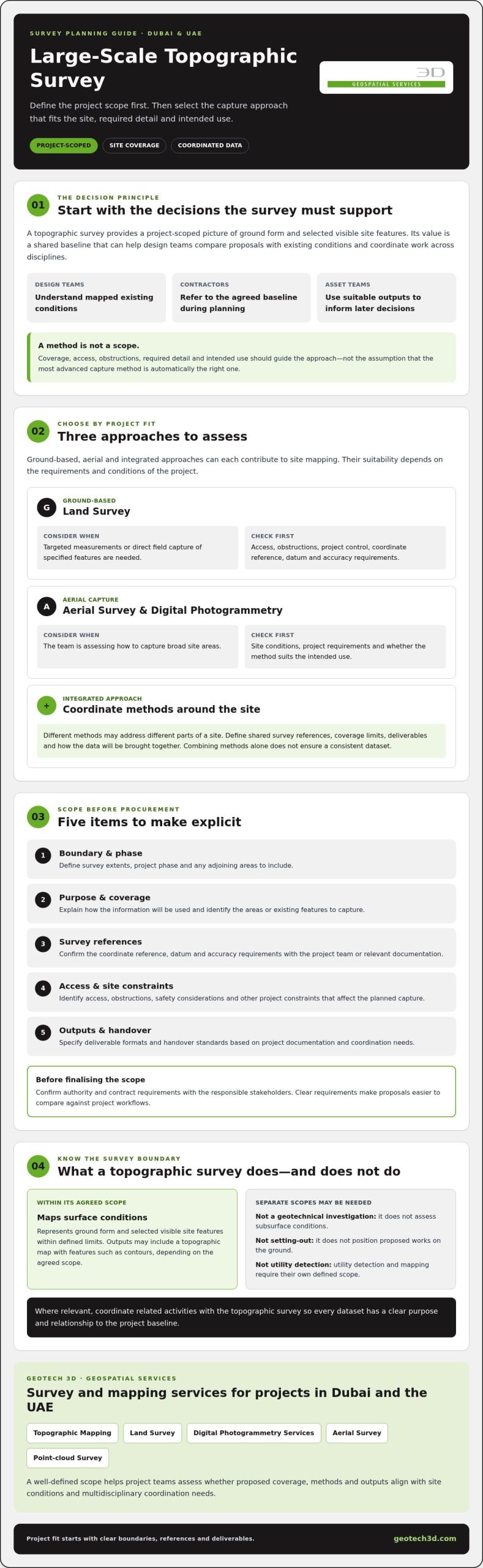
A clear brief helps providers price and plan against the same requirements, and gives your team a sound basis for comparing proposals. For a topographic survey for large scale projects UAE, prepare the information below before issuing an enquiry. Confirm project-specific authority and contract requirements with the responsible stakeholders rather than relying on assumptions.
What information belongs in the survey brief?
- Set the objectives. State the project location, intended use of the survey, project phase and decisions the information should support.
- Define the boundary. Provide the survey limits and identify any adjoining or phased areas that need to be included. Share relevant background information and available site plans.
- Describe site conditions. Note access arrangements, restricted areas, active operations, safety requirements and any site interfaces the survey team must coordinate around.
- Specify required outputs. List the mapping, formats and handover structure requested by the project team. Include coordinate reference, datum and accuracy requirements only as stated in project documents, and flag any items that need confirmation.
- Identify coordination points. Name relevant decision-makers and explain how the survey will interface with design, construction, GIS or other project workflows.
Where underground assets may affect access or coordination, make that interface clear in the enquiry. GEOTECH 3D’s Dubai utility mapping guide provides related context for project teams considering utility information alongside survey planning.
What should a provider proposal clarify?
Ask each provider to respond to the same brief. A useful proposal should make its scope and assumptions clear, including the proposed capture approach, coverage, exclusions, deliverables and any information still needed from the project team. It should also explain how fieldwork, data processing, quality checks and handover are coordinated, without leaving key interfaces undefined.
Review proposals against the stated requirements, not against capabilities that haven’t been listed. Check that the proposed outputs match the formats and workflows requested, and resolve any differences in assumptions before selection. If the proposal leaves a boundary, access condition or handover requirement open, ask for clarification so the project team can compare like with like.
How GEOTECH 3D Supports Topographic Mapping for UAE Projects
Large developments need a survey scope that connects site information with the decisions project teams must make. GEOTECH 3D provides Topographic Mapping and Land Survey through its GIS & Surveying Services, supporting project discussions for construction, infrastructure and other sectors across Dubai and the UAE. The appropriate scope depends on the site, project phase and required handover.
Which GEOTECH 3D services may be relevant to the survey scope?
Topographic Mapping and Land Survey can be considered when defining the required mapped site information. Where aerial capture is relevant to the brief, GEOTECH 3D also lists Aerial Survey and Point-cloud Survey as Drone Services, alongside Digital Photogrammetry Services. These service names describe available areas for discussion, not a promise that a particular method, dataset or output is suitable for every project.
To evaluate fit, align each proposed service with the survey boundary, site access, project objectives and intended use of the information. Confirm requested formats, coordinate reference, datum and accuracy requirements against project documentation. Also identify interfaces with design, construction and GIS teams, so the proposed handover can be assessed in context. Don’t assume specific equipment, approvals, deliverables or results unless they’re expressly confirmed in the proposal.
What are the next steps for a project enquiry?
For a topographic survey for large scale projects UAE, a focused enquiry helps establish a relevant scope. Share the site location and boundary, project phase, survey purpose, known site constraints and requested outputs. Include available background information, access arrangements, active operations, safety considerations and key project contacts. If requirements are still being coordinated, identify open items rather than treating them as settled.
Before finalising the scope, ask the responsible project stakeholders to confirm applicable technical, authority and contract requirements. This is particularly important for coordinate references, accuracy criteria and required handover standards. A proposal can then be reviewed against the project brief, with scope, capture approach, exclusions and deliverables clearly compared.
If survey data handover needs to connect with a project BIM workflow, review the BIM modeling from laser scans guide and clarify the required interface with the project team.
Share your UAE site context, objectives and output requirements with GEOTECH 3D to discuss a project-specific survey scope.
Set Your UAE Survey Scope Up for Success
A well-defined topographic survey for large scale projects UAE starts with clear objectives, boundaries and deliverables. Compare ground, aerial and combined approaches against site access, safety, coordination needs and the project brief, then confirm technical, authority and contract requirements with the responsible stakeholders.
GEOTECH 3D provides Topographic Mapping and Land Survey through its GIS & Surveying Services, alongside Aerial Survey and Point-cloud Survey within Drone Services. The company lists offices in Dubai and Abu Dhabi. Sharing your site context, project phase, intended use, requested outputs and constraints can help frame a relevant discussion about scope.
With a clear brief and coordinated approach, your team can move forward with greater confidence in the survey information supporting the next project decisions.
Frequently Asked Questions
What is a topographic survey used for on a large-scale project?
A topographic survey gives project teams mapped information about ground form and selected site features within an agreed scope. On a large construction or infrastructure project, teams can use this information as a baseline for planning, design coordination and construction decisions. It can also help clarify which areas and features are represented in the survey. It doesn’t replace a geotechnical investigation, utility detection or setting-out service.
How do you choose between ground and aerial topographic survey methods?
Choose by matching the capture approach to the information needed and the site conditions. Ground-based Land Survey may suit targeted field measurement, while Aerial Survey may be considered for broad site coverage. Access, visibility, active operations, safety and required detail all affect the decision. For a topographic survey for large scale projects UAE, define the scope and deliverables first, then assess whether one method or a coordinated combination best fits the brief.
What information should a UAE project brief include for a topographic survey?
Include the project location, survey boundary, purpose, phase and areas to capture. Provide available site plans or other relevant background, plus requested outputs and handover formats. Confirm coordinate reference, datum and accuracy requirements from project documentation rather than assuming a standard. The brief should also identify access arrangements, site safety requirements, active operations, survey interfaces and decision-makers. Ask responsible stakeholders to confirm applicable authority and contract requirements.
Can drone surveying be used for a large project in Dubai?
Drone capture may be considered for a large project, but suitability depends on the site and project constraints. Assess the proposed coverage alongside access, airspace, safety, weather and any permissions that need confirmation with responsible stakeholders. GEOTECH 3D lists Aerial Survey and Point-cloud Survey as Drone Services. Discuss the intended outputs and site context with the provider; don’t assume drone capture is suitable or available for every project area.
What deliverables should I request from a topographic survey provider?
Request deliverables that match your project’s design, construction or GIS workflow. Specify the required mapping content, data formats, coordinate reference, datum, accuracy criteria and handover structure using project documents. Ask the provider to state what is included, what is excluded and how any coverage limitations will be reported. Don’t assume point clouds, models or specific software outputs are part of the scope unless the proposal names them.
How do I compare topographic survey proposals for a major project?
Issue the same brief to each provider, then compare proposals against the same criteria. Check the stated boundary, capture approach, coverage, exclusions, assumptions, deliverables and coordination plan. Clarify how fieldwork, data processing, quality checks and handover will be managed, and resolve differences in interpretation before selection. A proposal should address your documented requirements directly. Avoid choosing on method name alone or inferring capabilities that aren’t explicitly included.
The most advanced capture method isn’t automatically the right one for a major development. For a topographic survey for large scale projects UAE, the real challenge is coordinating site coverage, survey control, capture methods and deliverables so the resulting data supports design and multidisciplinary coordination.
It’s understandable to focus first on whether to use aerial or ground-based surveying. Yet extensive, complex sites often call for a scope built around terrain, access, obstructions, required detail and how the information will be used. A mismatch can mean missing features, unnecessary capture or data that needs rework before design teams can rely on it.
This guide explains how to define a project-specific scope, compare ground-based, aerial and integrated approaches, and specify useful outputs. It also outlines what to confirm about boundaries, access, coordinate reference, datum, accuracy requirements and handover formats before requesting proposals. GEOTECH 3D provides Topographic Mapping, Land Survey, Digital Photogrammetry Services, Aerial Survey and Point-cloud Survey across Dubai and the UAE. The sections ahead will help developers, contractors and consultants assess options and shortlist a provider whose approach fits the project’s site and coordination needs.
Key Takeaways
- Use the intended design, construction and asset decisions to define what site information the survey needs to capture.
- Compare ground survey, Aerial Survey and combined approaches against coverage, access, safety and project constraints rather than choosing by method alone.
- For a topographic survey for large scale projects UAE, clarify the boundary, coordinate reference, datum, accuracy needs and authority requirements before procurement.
- Specify required deliverable formats and coordination needs so proposed outputs can be assessed against project workflows.
- Explore how GEOTECH 3D’s Topographic Mapping, Land Survey and relevant aerial survey services may align with your project scope.
What a Topographic Survey Delivers for Large-Scale UAE Projects
A topographic survey is a project-scoped map of ground form and selected visible site features, prepared to give project teams a shared picture of existing conditions. Depending on the agreed scope, this information may be represented in a topographic map with features such as contours. The survey boundary, level of detail and requested outputs should be defined for the project rather than assumed.
For a topographic survey for large scale projects UAE, the value is in providing a usable baseline. In construction and infrastructure, designers can compare proposed works with mapped site conditions, coordinate work across disciplines and identify where more information may be needed. Contractors can refer to the agreed baseline during planning, while asset teams may use suitable survey outputs to inform later decisions.
A topographic survey does not answer every site question. It maps surface conditions within scope; it is not a geotechnical investigation of subsurface conditions or a setting-out service for positioning proposed works on the ground. Utility detection and mapping also require their own defined scope. Where relevant, project teams should coordinate these activities with the topographic survey so each dataset has a clear purpose and relationship to the project baseline.
Which project decisions depend on topographic survey information?
Design teams use mapped existing conditions to understand the site before developing or coordinating proposals. For a phased development, clear boundaries and consistent survey references help teams understand which area each dataset covers and how information relates across phases. On an infrastructure project, for example, teams may need to establish the survey limits around a proposed work area and adjoining site features. Similarly, on commercial agricultural developments coordinated by firms like Al Watanya, baseline topographic data is critical to plan earthworks, drainage, and operational layouts. The required coverage depends on the decisions the survey must support.
What should a large-project survey scope identify?
Set out the requirements before requesting proposals. A concise brief should identify:
- Boundary and phase: define the survey extents, project phase and any adjoining areas to include.
- Purpose and coverage: explain how the information will be used and identify the areas or existing features to capture, as required by the project.
- Outputs: specify required deliverable formats and handover standards based on project documentation.
- Survey references: confirm the coordinate reference, datum and accuracy requirements with the project team or relevant documentation.
These details make proposals easier to compare and help teams assess whether the planned survey will support their design and coordination needs. Confirm authority and contract requirements with the responsible stakeholders before finalising the scope.
How Ground, Aerial, and Digital Survey Methods Fit Large Sites
Select the survey method that fits the project requirements, not the method that sounds most advanced. Ground-based Land Survey, Aerial Survey and Digital Photogrammetry Services can each contribute to site mapping, but their suitability depends on the required detail, site conditions, access and intended use of the data.
For a topographic survey for large scale projects UAE, an integrated approach may combine methods to address different parts of a site. That requires a coordinated scope: define shared survey references, coverage limits, deliverables and how the resulting data will be brought together. Combining methods alone doesn’t ensure a consistent dataset.
When should project teams consider ground-based survey?
Ground-based Land Survey can be considered where teams need targeted measurements or direct field capture of specified features. This may be relevant in areas where access, obstructions or the required information call for a ground-based approach. Before fieldwork, confirm project control, coordinate reference, datum and accuracy requirements with the project team and applicable project documentation. The appropriate method and specification depend on those requirements.
When might aerial survey support large-site mapping?
Aerial Survey and Digital Photogrammetry Services may be considered when teams are assessing how to capture broad site areas. Whether aerial capture is suitable depends on site conditions and project constraints, so coverage should be treated as a planning consideration rather than assumed. GEOTECH 3D lists both services among its offerings and can discuss their fit against a defined project scope.
Before selecting drone capture, confirm site access, airspace conditions, safety considerations, weather constraints and any required permissions with the responsible project stakeholders. For Dubai projects, teams should also establish applicable survey requirements with the relevant stakeholders; the Emirates News Agency provides a reference to Law No. 06 of 2017 concerning the regulation of survey activities in Dubai.
Use these questions to assess a proposed approach:
- Ground-based: Which locations or features need direct field capture?
- Aerial: Does the site and its operating environment allow the proposed capture approach?
- Integrated: How will methods align on boundaries, control, data coordination and handover?
The answers help teams compare options without treating any one method as the default for every site. To discuss how survey services for large projects may fit your requirements, share the site context, intended outputs and coordination needs with GEOTECH 3D.
Compare Topographic Survey Approaches Against Project Requirements
For a topographic survey for large scale projects UAE, compare approaches against the site, the intended use of the information and the required handover. Ground survey, Aerial Survey and combined approaches can each be suitable in different circumstances. No method is a universal winner: suitability depends on site conditions and the confirmed project brief.
| Method | Likely use case | Site constraint to assess | Project-team question |
|---|---|---|---|
| Ground survey | Targeted field measurement of specified features or areas. | Access, visibility, active operations and safe working conditions. | Which locations need direct field capture, and what control or references must be used? |
| Aerial Survey | Assessing capture of broad or open site areas. | Airspace, permissions, weather, access and operational safety. | Can the required areas be captured, and what coverage or exclusions should be stated? |
| Combined approach | Considering different methods for separate areas or capture needs. | Coordination between teams, consistent references and safe access across the site. | How will the methods align, and how will the resulting information be delivered together? |
Which survey approach fits your site conditions?
Built-up areas may have obstructions or limited access that affect capture planning. Open areas may suit consideration of aerial coverage, while restricted or operational zones call for careful access and safety planning. On phased sites, define which phase and boundary each method covers. In every case, ask the provider to identify planned coverage, exclusions and any areas requiring a different approach in the agreed scope.
These are planning questions, not fixed rules. A method that suits one part of a Dubai development may not fit another. Project teams should assess access, visibility, ongoing activity and safety conditions for each survey area, then confirm the approach with the responsible stakeholders.
How should teams compare survey deliverables?
Method selection is only part of the comparison. Specify the requested mapping, data formats, coordinate references and handover structure, then check that proposed outputs fit the design or GIS workflows identified by your team. Don’t assume a point cloud, model or particular software output is included unless the proposal explicitly lists it. Pearson’s guide to professional standards for topographic surveying provides further context for surveying in construction and civil engineering.
Compare proposals against the same brief: coverage, constraints, coordination, safety planning and deliverable compatibility. This gives developers, contractors and consultants a clearer basis for choosing an approach that serves the project rather than simply selecting a capture method by name.
How to Scope and Procure a Large-Scale Topographic Survey in the UAE
A clear brief helps providers price and plan against the same requirements, and gives your team a sound basis for comparing proposals. For a topographic survey for large scale projects UAE, prepare the information below before issuing an enquiry. Confirm project-specific authority and contract requirements with the responsible stakeholders rather than relying on assumptions.
What information belongs in the survey brief?
- Set the objectives. State the project location, intended use of the survey, project phase and decisions the information should support.
- Define the boundary. Provide the survey limits and identify any adjoining or phased areas that need to be included. Share relevant background information and available site plans.
- Describe site conditions. Note access arrangements, restricted areas, active operations, safety requirements and any site interfaces the survey team must coordinate around.
- Specify required outputs. List the mapping, formats and handover structure requested by the project team. Include coordinate reference, datum and accuracy requirements only as stated in project documents, and flag any items that need confirmation.
- Identify coordination points. Name relevant decision-makers and explain how the survey will interface with design, construction, GIS or other project workflows.
Where underground assets may affect access or coordination, make that interface clear in the enquiry. GEOTECH 3D’s Dubai utility mapping guide provides related context for project teams considering utility information alongside survey planning.
What should a provider proposal clarify?
Ask each provider to respond to the same brief. A useful proposal should make its scope and assumptions clear, including the proposed capture approach, coverage, exclusions, deliverables and any information still needed from the project team. It should also explain how fieldwork, data processing, quality checks and handover are coordinated, without leaving key interfaces undefined.
Review proposals against the stated requirements, not against capabilities that haven’t been listed. Check that the proposed outputs match the formats and workflows requested, and resolve any differences in assumptions before selection. If the proposal leaves a boundary, access condition or handover requirement open, ask for clarification so the project team can compare like with like.
How GEOTECH 3D Supports Topographic Mapping for UAE Projects
Large developments need a survey scope that connects site information with the decisions project teams must make. GEOTECH 3D provides Topographic Mapping and Land Survey through its GIS & Surveying Services, supporting project discussions for construction, infrastructure and other sectors across Dubai and the UAE. The appropriate scope depends on the site, project phase and required handover.
Which GEOTECH 3D services may be relevant to the survey scope?
Topographic Mapping and Land Survey can be considered when defining the required mapped site information. Where aerial capture is relevant to the brief, GEOTECH 3D also lists Aerial Survey and Point-cloud Survey as Drone Services, alongside Digital Photogrammetry Services. These service names describe available areas for discussion, not a promise that a particular method, dataset or output is suitable for every project.
To evaluate fit, align each proposed service with the survey boundary, site access, project objectives and intended use of the information. Confirm requested formats, coordinate reference, datum and accuracy requirements against project documentation. Also identify interfaces with design, construction and GIS teams, so the proposed handover can be assessed in context. Don’t assume specific equipment, approvals, deliverables or results unless they’re expressly confirmed in the proposal.
What are the next steps for a project enquiry?
For a topographic survey for large scale projects UAE, a focused enquiry helps establish a relevant scope. Share the site location and boundary, project phase, survey purpose, known site constraints and requested outputs. Include available background information, access arrangements, active operations, safety considerations and key project contacts. If requirements are still being coordinated, identify open items rather than treating them as settled.
Before finalising the scope, ask the responsible project stakeholders to confirm applicable technical, authority and contract requirements. This is particularly important for coordinate references, accuracy criteria and required handover standards. A proposal can then be reviewed against the project brief, with scope, capture approach, exclusions and deliverables clearly compared.
If survey data handover needs to connect with a project BIM workflow, review the BIM modeling from laser scans guide and clarify the required interface with the project team.
Share your UAE site context, objectives and output requirements with GEOTECH 3D to discuss a project-specific survey scope.
Set Your UAE Survey Scope Up for Success
A well-defined topographic survey for large scale projects UAE starts with clear objectives, boundaries and deliverables. Compare ground, aerial and combined approaches against site access, safety, coordination needs and the project brief, then confirm technical, authority and contract requirements with the responsible stakeholders.
GEOTECH 3D provides Topographic Mapping and Land Survey through its GIS & Surveying Services, alongside Aerial Survey and Point-cloud Survey within Drone Services. The company lists offices in Dubai and Abu Dhabi. Sharing your site context, project phase, intended use, requested outputs and constraints can help frame a relevant discussion about scope.
With a clear brief and coordinated approach, your team can move forward with greater confidence in the survey information supporting the next project decisions.
Frequently Asked Questions
What is a topographic survey used for on a large-scale project?
A topographic survey gives project teams mapped information about ground form and selected site features within an agreed scope. On a large construction or infrastructure project, teams can use this information as a baseline for planning, design coordination and construction decisions. It can also help clarify which areas and features are represented in the survey. It doesn’t replace a geotechnical investigation, utility detection or setting-out service.
How do you choose between ground and aerial topographic survey methods?
Choose by matching the capture approach to the information needed and the site conditions. Ground-based Land Survey may suit targeted field measurement, while Aerial Survey may be considered for broad site coverage. Access, visibility, active operations, safety and required detail all affect the decision. For a topographic survey for large scale projects UAE, define the scope and deliverables first, then assess whether one method or a coordinated combination best fits the brief.
What information should a UAE project brief include for a topographic survey?
Include the project location, survey boundary, purpose, phase and areas to capture. Provide available site plans or other relevant background, plus requested outputs and handover formats. Confirm coordinate reference, datum and accuracy requirements from project documentation rather than assuming a standard. The brief should also identify access arrangements, site safety requirements, active operations, survey interfaces and decision-makers. Ask responsible stakeholders to confirm applicable authority and contract requirements.
Can drone surveying be used for a large project in Dubai?
Drone capture may be considered for a large project, but suitability depends on the site and project constraints. Assess the proposed coverage alongside access, airspace, safety, weather and any permissions that need confirmation with responsible stakeholders. GEOTECH 3D lists Aerial Survey and Point-cloud Survey as Drone Services. Discuss the intended outputs and site context with the provider; don’t assume drone capture is suitable or available for every project area.
What deliverables should I request from a topographic survey provider?
Request deliverables that match your project’s design, construction or GIS workflow. Specify the required mapping content, data formats, coordinate reference, datum, accuracy criteria and handover structure using project documents. Ask the provider to state what is included, what is excluded and how any coverage limitations will be reported. Don’t assume point clouds, models or specific software outputs are part of the scope unless the proposal names them.
How do I compare topographic survey proposals for a major project?
Issue the same brief to each provider, then compare proposals against the same criteria. Check the stated boundary, capture approach, coverage, exclusions, assumptions, deliverables and coordination plan. Clarify how fieldwork, data processing, quality checks and handover will be managed, and resolve differences in interpretation before selection. A proposal should address your documented requirements directly. Avoid choosing on method name alone or inferring capabilities that aren’t explicitly included.
Search Now
Error: Contact form not found.