

Our Services
Topographical Land Survey in Saudi Arabia: The 2026 Geospatial Guide
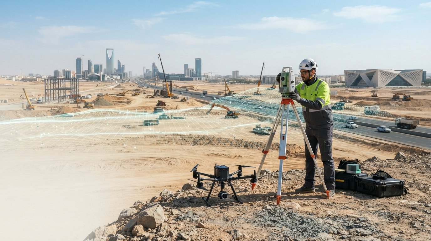
In 2026, the success of a mega-project no longer rests on the physical ground alone, but on the precision of its digital foundation. A professional topographical land survey Saudi Arabia has evolved from a simple boundary map into a high-fidelity dataset for intelligent infrastructure. You’ve likely dealt with the costly setbacks of inaccurate site data or the frustration of waiting for survey teams to mobilize in remote industrial corridors. These delays often stem from a disconnect between raw field results and the BIM platforms your engineers rely on.
GEOTECH 3D bridges this gap by delivering survey-grade accuracy that integrates directly into your planning workflows. Through our Riyadh office, we deploy advanced technology like the DJI Zenmuse H20T to capture comprehensive data with unprecedented speed. This guide explores how high-precision data acquisition and our Geoverse Platform are accelerating large-scale projects across the Kingdom. You’ll discover how our 3D Scanning To BIM services eliminate data silos, ensuring your project stays on schedule and your design remains flawless from day one.
Key Takeaways
- Learn why high-precision mapping serves as the essential digital foundation for Saudi Arabia’s 2026 infrastructure and industrial projects.
- Understand how UAV-based data collection and Mobile LiDAR streamline the acquisition of survey-grade data for vast urban networks and corridors.
- Discover how a professional topographical land survey Saudi Arabia reduces construction delays by eliminating data silos between field results and BIM platforms.
- Identify the rigorous safety and compliance standards required for surveying sensitive Oil & Gas brownfields and energy sectors.
- Explore the technical workflow for converting raw geospatial data into BIM-ready models and Digital Twins using the Geoverse Platform.
The Essential Role of Topographical Land Survey in Saudi Arabia’s Development
A topographical land survey Saudi Arabia serves as the fundamental blueprint for any physical development. It involves the meticulous mapping of both natural terrain and man-made structures to create a detailed representation of the earth’s surface. While traditional methods focused on horizontal boundaries, the 2026 standard demands a three-dimensional approach. This shift ensures that every ridge, utility line, and elevation change is recorded with survey-grade precision. By adhering to established land surveying principles, engineers can visualize the complex interplay between the existing environment and proposed designs before the first shovel hits the ground.
Modern infrastructure in the Kingdom requires more than just a flat map. Accurate elevation data is vital for managing water catchment and designing resilient drainage systems. In arid regions, understanding how water flows across the terrain during rare but intense rainfall prevents catastrophic flooding and protects multi-billion dollar assets. By providing high-fidelity datasets, we allow project managers to simulate environmental impacts with total confidence. While we support projects across the GCC, including the high-density urban developments in Dubai and the UAE, our Riyadh office provides the specialized local expertise needed for the Kingdom’s unique terrain.
Why Precision Matters for KSA Mega-Projects
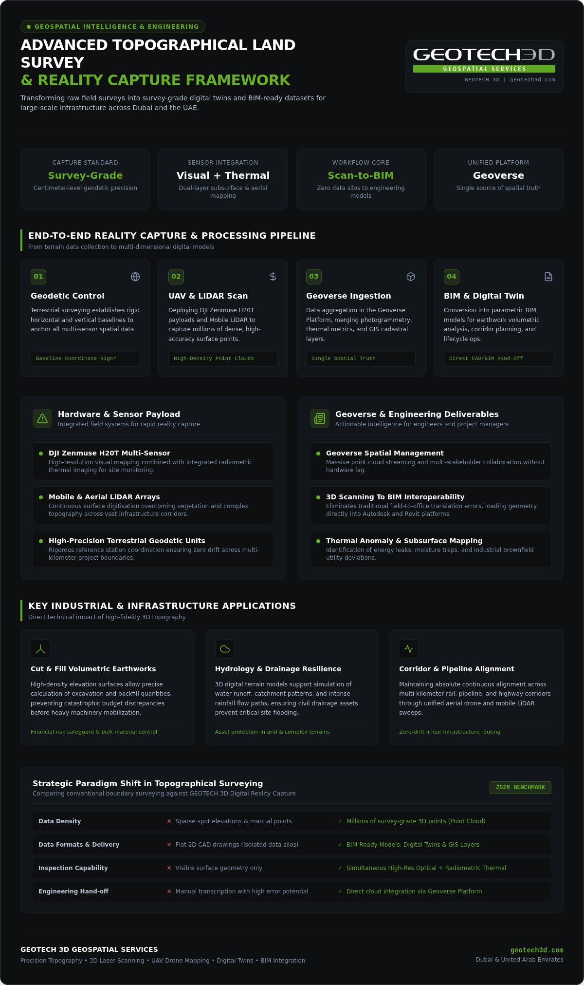
Precision isn’t just a technical preference; it’s a financial safeguard. On mega-projects, even minor discrepancies in initial data lead to massive errors in volumetric calculations for earthworks. High-precision data ensures that cut-and-fill requirements are calculated accurately, which directly controls project costs. For corridor projects like pipelines or high-speed rail, maintaining perfect alignment over hundreds of kilometers is only possible through rigorous geospatial control. Our teams in Riyadh utilize advanced sensors to mitigate these risks, ensuring that theoretical designs match the physical reality of the site.
Geospatial Data as a Strategic Asset
Data is now a strategic asset that extends far beyond the construction phase. We don’t just provide points on a map; we deliver rich GIS integration that supports national cadastral initiatives and urban planning. By transitioning from simple surveys to complex datasets, we enable 3D Scanning To BIM workflows that serve the entire project lifecycle. This high-level coordination allows developers to maintain a digital thread from initial planning to long-term asset management. Integrating these surveys into the Geoverse Platform ensures that stakeholders have a single source of truth for all spatial information.
Advanced Data Acquisition: Leveraging Drone and LiDAR Technology
The current geospatial environment demands a shift from manual spot-checks to comprehensive reality capture. In 2026, a topographical land survey Saudi Arabia relies on a multi-layered sensor approach to meet the rigorous demands of industrial development. Traditional terrestrial surveying still provides the necessary geodetic control, but modern projects require the density and speed of UAVs and LiDAR. This technological leap ensures that every project remains compliant with the standards established by the General Authority for Survey and Geospatial Information while significantly reducing mobilization times in remote areas.
By moving away from sparse point collection to full-scale digital replicas, we eliminate the data gaps that often lead to construction delays. Our Riyadh office utilizes high-end sensors to capture millions of data points across vast terrains, ensuring that no detail is overlooked. This approach isn’t just about speed; it’s about providing a reliable foundation for complex engineering decisions.
Drone Services and Aerial Mapping Capabilities
Aerial platforms offer a macro-view that terrestrial teams can’t match within the same timeframe. We deploy the DJI Zenmuse H20T, a sophisticated multi-sensor payload that integrates high-resolution visual data with thermal imaging. This allows for simultaneous topographical mapping and thermal site monitoring, which is critical for identifying subsurface anomalies or energy leaks in industrial zones. By processing this data through advanced photogrammetry, we generate survey-grade point clouds that reflect the true state of the site. These deliverables allow for rapid site monitoring and volumetric analysis, providing project managers with actionable insights in a fraction of the time required by traditional methods.
LiDAR and 3D Laser Scanning for High-Density Data
While drones cover vast expanses, 3D Laser Scanning and LiDAR handle the intricate details of complex environments. For brownfield industrial sites and Oil & Gas facilities, high-density data capture is essential to map existing piping, structural steel, and machinery. LiDAR sensors emit millions of laser pulses per second to create a precise digital twin of the facility, even in low-light conditions. This method is particularly effective for volumetric mining surveys and capturing “over-ceiling” or confined space data where human access is restricted or hazardous. If your project requires this level of technical detail, you can explore our specialized drone and scanning services to see how we support industrial excellence.
The transition from raw point clouds to 3D Scanning To BIM workflows ensures that the captured data is immediately useful for architects and engineers. By integrating these high-density scans into the Geoverse Platform, we provide a central repository for all spatial data, allowing for seamless collaboration across global teams.
Industry Applications: From Oil & Gas to Smart City Planning
Data-driven decisions are the backbone of industrial efficiency. In the energy-rich landscape of the Kingdom, a topographical land survey Saudi Arabia provides the spatial intelligence required to manage complex assets with absolute confidence. Beyond initial construction, these surveys facilitate volumetric analysis for mining operations and stockpile management, allowing for precise inventory control. By utilizing LiDAR remote sensing technology, we capture high-precision 3D models that serve as the geospatial foundation for smart city management. This ensures that every utility line and structural feature is accounted for in a centralized digital environment, reducing the risk of infrastructure conflicts.
Surveying for Oil & Gas Facilities
The energy sector demands a level of precision and safety that traditional surveying often fails to meet. Our teams specialize in mapping pipelines, power plants, and brownfield facilities where hazardous conditions are the norm. We prioritize strict safety compliance, ensuring that our field personnel and equipment meet the highest industrial standards. The resulting survey data isn’t just a static map; it’s an intelligent dataset that integrates directly into specialized CAD packages. This allows engineers to plan modifications and maintenance with a complete understanding of the existing structural constraints, which is vital for preventing costly onsite errors during facility upgrades.
Urban Development and Real Estate
As urban centers expand, the need for accurate cadastral and topographic mapping becomes paramount for sustainable growth. We support large-scale master planning by providing the granular detail required for residential and commercial strata services. This level of detail is equally critical in Dubai and the wider UAE, where high-density developments require flawless spatial coordination. Our topographic surveys provide the baseline for land-tax mapping and heritage preservation, creating permanent digital records of museum sites and historical landmarks. By transitioning this data into 3D Scanning To BIM outputs, we empower developers to move from raw land to finished assets with a continuous, accurate data trail.
These applications are most effective when the data is accessible and actionable for all stakeholders. Through the Geoverse Platform, we bridge the gap between field acquisition and office-based planning. This centralized approach ensures that whether you’re managing a remote pipeline or a metropolitan smart city project, your team has access to survey-grade information. You can visit our main site to see how these geospatial solutions integrate with your specific industry requirements and project goals.
Ensuring Accuracy, Safety, and Compliance in KSA Projects
Success in the Kingdom’s industrial sector depends on more than just high-end hardware; it requires a deep commitment to regulatory compliance and operational safety. A professional topographical land survey Saudi Arabia must adhere to strict licensing requirements to ensure that data is legally recognized for permitting and engineering design. We understand that on high-stakes projects, there’s no room for error. Our Riyadh office operates with the local expertise necessary to navigate these complex frameworks, ensuring that every dataset we deliver is both technically superior and fully compliant with regional standards.
Technical Standards and Quality Control
Maintaining survey-grade precision requires a rigorous data validation process that begins long before the sensors are activated. We establish a dense network of control points and benchmarks to anchor every scan to a unified geodetic framework. This foundation is critical for the following project stages:
- Initial Site Assessment: Establishing high-level terrain models for feasibility studies.
- Engineering Design: Providing sub-centimeter accuracy for structural alignment and utility tie-ins.
- Construction Supervision: Using as-built data to verify work against the original design intent.
Our quality assurance protocols extend to the office environment, where raw point clouds are meticulously cleaned and verified before being converted into final deliverables. This careful processing ensures that the transition to 3D Scanning To BIM is seamless and that the resulting models are free from the noise or artifacts that can plague lower-quality surveys.
Operational Safety in the Middle East
Operating a topographical land survey Saudi Arabia in remote desert or mountainous terrain requires more than just technical skill; it demands robust logistics and environmental resilience. In industrial and Oil & Gas brownfields, our teams follow stringent safety protocols to manage risks in hazardous zones. This includes specialized training for drone operations in high-interference urban areas and the use of specialized equipment where required. We also manage the complex logistics of mobilizing teams into areas where environmental factors like extreme heat and shifting sands can impact both personnel and sensor performance.
During peak summer months, we implement heat-stress management plans to protect our field staff without compromising project timelines. This proactive approach to safety allows us to meet tight schedules while maintaining the integrity of the data. Our commitment to excellence is backed by our local presence; you can reach our team at the Riyadh office at +966 55 781 6861 to discuss your site-specific safety and compliance requirements.
GEOTECH 3D: Your Partner for Topographical Surveying in Riyadh
GEOTECH 3D serves as a bridge between complex geospatial data and successful project delivery. Our Riyadh office provides the local presence required for rapid mobilization across the Kingdom, ensuring that your project benefits from regional expertise and global technical standards. We don’t just deliver maps; we provide a high-precision digital foundation that supports every phase of the construction lifecycle. By choosing a partner that understands the specific demands of a topographical land survey Saudi Arabia, you’re securing a relationship built on technical integrity and long-term commitment. Our presence in Riyadh ensures we can meet tight project schedules while adhering to the highest standards of accuracy.
The Geoverse Platform and Digital Twin Integration
The true value of modern geospatial data lies in its longevity. Through the Geoverse Platform, we transform static survey results into dynamic Digital Twins that evolve alongside your physical assets. This integration allows for city-scale modeling and real-time spatial analysis, providing asset owners with a comprehensive view of their infrastructure. Whether you’re managing a single industrial facility or a sprawling urban network, our platform ensures that your survey data remains accessible and actionable for years to come. This transition from raw data to smart management is a key differentiator for projects aiming for 2026 operational excellence. It allows stakeholders to simulate scenarios and optimize maintenance schedules with total spatial confidence.
Comprehensive Geospatial Solutions in Riyadh
Our multidisciplinary team brings years of experience across the Middle East, offering end-to-end solutions that move seamlessly from the field to the design office. We specialize in converting high-density point clouds into customized deliverables, including BIM Modeling from Laser Scans. This ensures that your architectural and engineering teams receive models that are ready for immediate use in Revit or other CAD platforms. We prioritize clear communication and meticulous quality control to ensure that every project meets its technical requirements without compromise. This methodical approach mirrors the standards we maintain for our high-density developments in Dubai and the UAE.
For organizations requiring rapid mobilization or technical consultation, our local team is ready to assist. You can reach our Riyadh office directly at +966 55 781 6861 or via email at ksa@geotech3d.com. We offer scalable solutions tailored to the unique needs of the energy, construction, and government sectors, providing the survey-grade accuracy your project demands. By integrating 3D Scanning To BIM with a professional topographical land survey Saudi Arabia, we provide a holistic view of your site that minimizes risk and maximizes efficiency throughout the asset’s lifecycle.
Building the Future with Geospatial Intelligence
The evolution of topographical land survey Saudi Arabia in 2026 has transformed raw terrain data into a strategic asset for the Kingdom’s most ambitious projects. By integrating high-precision data acquisition via the DJI Zenmuse H20T with advanced 3D Scanning To BIM workflows, developers can now mitigate risks and accelerate project timelines with absolute certainty. We’ve explored how accurate mapping, rigorous safety compliance, and the Geoverse Platform create a seamless bridge between initial site assessment and long-term asset management.
Securing survey-grade accuracy is no longer just a preliminary step; it’s a commitment to the entire lifecycle of your infrastructure. Our Riyadh team provides the local mobilization and technical expertise needed to turn complex physical environments into actionable digital intelligence. For direct inquiries, contact our Riyadh office at +966 55 781 6861 or reach us via ksa@geotech3d.com to discuss your specific site requirements and technical goals.
We look forward to partnering with you to deliver the precision and reliability your next milestone project deserves.
Frequently Asked Questions
What is included in a standard topographical land survey in Saudi Arabia?
A standard topographical land survey Saudi Arabia includes the precise mapping of natural terrain and man-made structures like roads, buildings, and utilities. We provide detailed elevation data and contour maps that are essential for drainage design and earthwork calculations. Our deliverables often include GIS-ready datasets and cadastral information. This level of detail is similar to the standards we maintain for high-density infrastructure projects across Dubai and the UAE.
How long does it take to mobilize a survey team in Riyadh or remote areas?
Our local presence in Riyadh allows for rapid mobilization, often within a few business days depending on the project’s scale. For remote industrial sites or desert terrain, we leverage our regional logistics network to ensure teams and equipment arrive on schedule. You can coordinate mobilization directly through our Riyadh office at +966 55 781 6861. This local agility ensures we meet the tight deadlines common in the Middle East’s construction sector.
What are the advantages of using drones for topographical mapping?
Drones provide a macro-perspective and significantly faster data collection compared to traditional ground teams. We utilize the DJI Zenmuse H20T to capture high-resolution visual and thermal data simultaneously. This is particularly beneficial for site monitoring, volumetric analysis in mining, and inspecting hazardous areas without risking personnel. Aerial mapping allows for the rapid creation of digital twins, a process we also implement for large-scale developments in Dubai and the UAE.
How does GEOTECH 3D ensure the accuracy of its topographical data?
Accuracy is maintained through a combination of high-end sensors and rigorous field protocols. We use equipment like the Faro S350 and Leica RTC 360 to capture survey-grade point clouds. Every topographical land survey Saudi Arabia we conduct is anchored to a unified geodetic framework using established control points and benchmarks. Our data validation process ensures that the final deliverables meet the sub-centimeter precision required for complex engineering and design tasks.
Can topographical survey data be converted directly into a BIM model?
Yes, we specialize in 3D Scanning To BIM, which converts raw geospatial data into intelligent 3D models. This process bridges the gap between field surveying and architectural design. Our multidisciplinary team cleans and processes point cloud data to create BIM-ready models compatible with standard CAD packages. This workflow ensures that your design team has a flawless digital replica of the site, reducing the risk of clashes during the construction phase.
What safety certifications do GEOTECH 3D survey teams follow in KSA?
Our teams follow strict safety protocols tailored for industrial and hazardous environments, including Oil & Gas brownfields. We prioritize compliance with regional safety standards for both ground personnel and drone operations. This includes specialized training for working in remote desert areas and high-temperature environments. Our commitment to safety is as rigorous as the standards we apply to our projects in Dubai and the UAE, ensuring zero-compromise data integrity.
Which industries in Saudi Arabia benefit most from 3D laser scanning?
The Oil & Gas, mining, and urban development sectors benefit most from 3D laser scanning. In the energy sector, it’s used for mapping complex pipelines and power plants with total accuracy. Mining operations utilize it for precise volumetric surveys of stockpiles. Additionally, government bodies use this technology for cadastral mapping and heritage preservation. These industries rely on high-density data to manage assets efficiently and support the development of smart cities.
How do I request a quote for a land survey project in Saudi Arabia?
You can request a professional quote by contacting our Riyadh office directly at +966 55 781 6861 or emailing ksa@geotech3d.com. Provide your project location, site size, and specific requirements like 3D Scanning To BIM or drone mapping. Our team will evaluate the scope and provide a detailed proposal tailored to your project’s timeline. We offer comprehensive geospatial solutions that meet the technical demands of the Saudi Arabian and UAE markets.
In 2026, the success of a mega-project no longer rests on the physical ground alone, but on the precision of its digital foundation. A professional topographical land survey Saudi Arabia has evolved from a simple boundary map into a high-fidelity dataset for intelligent infrastructure. You’ve likely dealt with the costly setbacks of inaccurate site data or the frustration of waiting for survey teams to mobilize in remote industrial corridors. These delays often stem from a disconnect between raw field results and the BIM platforms your engineers rely on.
GEOTECH 3D bridges this gap by delivering survey-grade accuracy that integrates directly into your planning workflows. Through our Riyadh office, we deploy advanced technology like the DJI Zenmuse H20T to capture comprehensive data with unprecedented speed. This guide explores how high-precision data acquisition and our Geoverse Platform are accelerating large-scale projects across the Kingdom. You’ll discover how our 3D Scanning To BIM services eliminate data silos, ensuring your project stays on schedule and your design remains flawless from day one.
Key Takeaways
- Learn why high-precision mapping serves as the essential digital foundation for Saudi Arabia’s 2026 infrastructure and industrial projects.
- Understand how UAV-based data collection and Mobile LiDAR streamline the acquisition of survey-grade data for vast urban networks and corridors.
- Discover how a professional topographical land survey Saudi Arabia reduces construction delays by eliminating data silos between field results and BIM platforms.
- Identify the rigorous safety and compliance standards required for surveying sensitive Oil & Gas brownfields and energy sectors.
- Explore the technical workflow for converting raw geospatial data into BIM-ready models and Digital Twins using the Geoverse Platform.
The Essential Role of Topographical Land Survey in Saudi Arabia’s Development
A topographical land survey Saudi Arabia serves as the fundamental blueprint for any physical development. It involves the meticulous mapping of both natural terrain and man-made structures to create a detailed representation of the earth’s surface. While traditional methods focused on horizontal boundaries, the 2026 standard demands a three-dimensional approach. This shift ensures that every ridge, utility line, and elevation change is recorded with survey-grade precision. By adhering to established land surveying principles, engineers can visualize the complex interplay between the existing environment and proposed designs before the first shovel hits the ground.
Modern infrastructure in the Kingdom requires more than just a flat map. Accurate elevation data is vital for managing water catchment and designing resilient drainage systems. In arid regions, understanding how water flows across the terrain during rare but intense rainfall prevents catastrophic flooding and protects multi-billion dollar assets. By providing high-fidelity datasets, we allow project managers to simulate environmental impacts with total confidence. While we support projects across the GCC, including the high-density urban developments in Dubai and the UAE, our Riyadh office provides the specialized local expertise needed for the Kingdom’s unique terrain.
Why Precision Matters for KSA Mega-Projects
Precision isn’t just a technical preference; it’s a financial safeguard. On mega-projects, even minor discrepancies in initial data lead to massive errors in volumetric calculations for earthworks. High-precision data ensures that cut-and-fill requirements are calculated accurately, which directly controls project costs. For corridor projects like pipelines or high-speed rail, maintaining perfect alignment over hundreds of kilometers is only possible through rigorous geospatial control. Our teams in Riyadh utilize advanced sensors to mitigate these risks, ensuring that theoretical designs match the physical reality of the site.
Geospatial Data as a Strategic Asset
Data is now a strategic asset that extends far beyond the construction phase. We don’t just provide points on a map; we deliver rich GIS integration that supports national cadastral initiatives and urban planning. By transitioning from simple surveys to complex datasets, we enable 3D Scanning To BIM workflows that serve the entire project lifecycle. This high-level coordination allows developers to maintain a digital thread from initial planning to long-term asset management. Integrating these surveys into the Geoverse Platform ensures that stakeholders have a single source of truth for all spatial information.
Advanced Data Acquisition: Leveraging Drone and LiDAR Technology
The current geospatial environment demands a shift from manual spot-checks to comprehensive reality capture. In 2026, a topographical land survey Saudi Arabia relies on a multi-layered sensor approach to meet the rigorous demands of industrial development. Traditional terrestrial surveying still provides the necessary geodetic control, but modern projects require the density and speed of UAVs and LiDAR. This technological leap ensures that every project remains compliant with the standards established by the General Authority for Survey and Geospatial Information while significantly reducing mobilization times in remote areas.
By moving away from sparse point collection to full-scale digital replicas, we eliminate the data gaps that often lead to construction delays. Our Riyadh office utilizes high-end sensors to capture millions of data points across vast terrains, ensuring that no detail is overlooked. This approach isn’t just about speed; it’s about providing a reliable foundation for complex engineering decisions.
Drone Services and Aerial Mapping Capabilities
Aerial platforms offer a macro-view that terrestrial teams can’t match within the same timeframe. We deploy the DJI Zenmuse H20T, a sophisticated multi-sensor payload that integrates high-resolution visual data with thermal imaging. This allows for simultaneous topographical mapping and thermal site monitoring, which is critical for identifying subsurface anomalies or energy leaks in industrial zones. By processing this data through advanced photogrammetry, we generate survey-grade point clouds that reflect the true state of the site. These deliverables allow for rapid site monitoring and volumetric analysis, providing project managers with actionable insights in a fraction of the time required by traditional methods.
LiDAR and 3D Laser Scanning for High-Density Data
While drones cover vast expanses, 3D Laser Scanning and LiDAR handle the intricate details of complex environments. For brownfield industrial sites and Oil & Gas facilities, high-density data capture is essential to map existing piping, structural steel, and machinery. LiDAR sensors emit millions of laser pulses per second to create a precise digital twin of the facility, even in low-light conditions. This method is particularly effective for volumetric mining surveys and capturing “over-ceiling” or confined space data where human access is restricted or hazardous. If your project requires this level of technical detail, you can explore our specialized drone and scanning services to see how we support industrial excellence.
The transition from raw point clouds to 3D Scanning To BIM workflows ensures that the captured data is immediately useful for architects and engineers. By integrating these high-density scans into the Geoverse Platform, we provide a central repository for all spatial data, allowing for seamless collaboration across global teams.
Industry Applications: From Oil & Gas to Smart City Planning
Data-driven decisions are the backbone of industrial efficiency. In the energy-rich landscape of the Kingdom, a topographical land survey Saudi Arabia provides the spatial intelligence required to manage complex assets with absolute confidence. Beyond initial construction, these surveys facilitate volumetric analysis for mining operations and stockpile management, allowing for precise inventory control. By utilizing LiDAR remote sensing technology, we capture high-precision 3D models that serve as the geospatial foundation for smart city management. This ensures that every utility line and structural feature is accounted for in a centralized digital environment, reducing the risk of infrastructure conflicts.
Surveying for Oil & Gas Facilities
The energy sector demands a level of precision and safety that traditional surveying often fails to meet. Our teams specialize in mapping pipelines, power plants, and brownfield facilities where hazardous conditions are the norm. We prioritize strict safety compliance, ensuring that our field personnel and equipment meet the highest industrial standards. The resulting survey data isn’t just a static map; it’s an intelligent dataset that integrates directly into specialized CAD packages. This allows engineers to plan modifications and maintenance with a complete understanding of the existing structural constraints, which is vital for preventing costly onsite errors during facility upgrades.
Urban Development and Real Estate
As urban centers expand, the need for accurate cadastral and topographic mapping becomes paramount for sustainable growth. We support large-scale master planning by providing the granular detail required for residential and commercial strata services. This level of detail is equally critical in Dubai and the wider UAE, where high-density developments require flawless spatial coordination. Our topographic surveys provide the baseline for land-tax mapping and heritage preservation, creating permanent digital records of museum sites and historical landmarks. By transitioning this data into 3D Scanning To BIM outputs, we empower developers to move from raw land to finished assets with a continuous, accurate data trail.
These applications are most effective when the data is accessible and actionable for all stakeholders. Through the Geoverse Platform, we bridge the gap between field acquisition and office-based planning. This centralized approach ensures that whether you’re managing a remote pipeline or a metropolitan smart city project, your team has access to survey-grade information. You can visit our main site to see how these geospatial solutions integrate with your specific industry requirements and project goals.
Ensuring Accuracy, Safety, and Compliance in KSA Projects
Success in the Kingdom’s industrial sector depends on more than just high-end hardware; it requires a deep commitment to regulatory compliance and operational safety. A professional topographical land survey Saudi Arabia must adhere to strict licensing requirements to ensure that data is legally recognized for permitting and engineering design. We understand that on high-stakes projects, there’s no room for error. Our Riyadh office operates with the local expertise necessary to navigate these complex frameworks, ensuring that every dataset we deliver is both technically superior and fully compliant with regional standards.
Technical Standards and Quality Control
Maintaining survey-grade precision requires a rigorous data validation process that begins long before the sensors are activated. We establish a dense network of control points and benchmarks to anchor every scan to a unified geodetic framework. This foundation is critical for the following project stages:
- Initial Site Assessment: Establishing high-level terrain models for feasibility studies.
- Engineering Design: Providing sub-centimeter accuracy for structural alignment and utility tie-ins.
- Construction Supervision: Using as-built data to verify work against the original design intent.
Our quality assurance protocols extend to the office environment, where raw point clouds are meticulously cleaned and verified before being converted into final deliverables. This careful processing ensures that the transition to 3D Scanning To BIM is seamless and that the resulting models are free from the noise or artifacts that can plague lower-quality surveys.
Operational Safety in the Middle East
Operating a topographical land survey Saudi Arabia in remote desert or mountainous terrain requires more than just technical skill; it demands robust logistics and environmental resilience. In industrial and Oil & Gas brownfields, our teams follow stringent safety protocols to manage risks in hazardous zones. This includes specialized training for drone operations in high-interference urban areas and the use of specialized equipment where required. We also manage the complex logistics of mobilizing teams into areas where environmental factors like extreme heat and shifting sands can impact both personnel and sensor performance.
During peak summer months, we implement heat-stress management plans to protect our field staff without compromising project timelines. This proactive approach to safety allows us to meet tight schedules while maintaining the integrity of the data. Our commitment to excellence is backed by our local presence; you can reach our team at the Riyadh office at +966 55 781 6861 to discuss your site-specific safety and compliance requirements.
GEOTECH 3D: Your Partner for Topographical Surveying in Riyadh
GEOTECH 3D serves as a bridge between complex geospatial data and successful project delivery. Our Riyadh office provides the local presence required for rapid mobilization across the Kingdom, ensuring that your project benefits from regional expertise and global technical standards. We don’t just deliver maps; we provide a high-precision digital foundation that supports every phase of the construction lifecycle. By choosing a partner that understands the specific demands of a topographical land survey Saudi Arabia, you’re securing a relationship built on technical integrity and long-term commitment. Our presence in Riyadh ensures we can meet tight project schedules while adhering to the highest standards of accuracy.
The Geoverse Platform and Digital Twin Integration
The true value of modern geospatial data lies in its longevity. Through the Geoverse Platform, we transform static survey results into dynamic Digital Twins that evolve alongside your physical assets. This integration allows for city-scale modeling and real-time spatial analysis, providing asset owners with a comprehensive view of their infrastructure. Whether you’re managing a single industrial facility or a sprawling urban network, our platform ensures that your survey data remains accessible and actionable for years to come. This transition from raw data to smart management is a key differentiator for projects aiming for 2026 operational excellence. It allows stakeholders to simulate scenarios and optimize maintenance schedules with total spatial confidence.
Comprehensive Geospatial Solutions in Riyadh
Our multidisciplinary team brings years of experience across the Middle East, offering end-to-end solutions that move seamlessly from the field to the design office. We specialize in converting high-density point clouds into customized deliverables, including BIM Modeling from Laser Scans. This ensures that your architectural and engineering teams receive models that are ready for immediate use in Revit or other CAD platforms. We prioritize clear communication and meticulous quality control to ensure that every project meets its technical requirements without compromise. This methodical approach mirrors the standards we maintain for our high-density developments in Dubai and the UAE.
For organizations requiring rapid mobilization or technical consultation, our local team is ready to assist. You can reach our Riyadh office directly at +966 55 781 6861 or via email at ksa@geotech3d.com. We offer scalable solutions tailored to the unique needs of the energy, construction, and government sectors, providing the survey-grade accuracy your project demands. By integrating 3D Scanning To BIM with a professional topographical land survey Saudi Arabia, we provide a holistic view of your site that minimizes risk and maximizes efficiency throughout the asset’s lifecycle.
Building the Future with Geospatial Intelligence
The evolution of topographical land survey Saudi Arabia in 2026 has transformed raw terrain data into a strategic asset for the Kingdom’s most ambitious projects. By integrating high-precision data acquisition via the DJI Zenmuse H20T with advanced 3D Scanning To BIM workflows, developers can now mitigate risks and accelerate project timelines with absolute certainty. We’ve explored how accurate mapping, rigorous safety compliance, and the Geoverse Platform create a seamless bridge between initial site assessment and long-term asset management.
Securing survey-grade accuracy is no longer just a preliminary step; it’s a commitment to the entire lifecycle of your infrastructure. Our Riyadh team provides the local mobilization and technical expertise needed to turn complex physical environments into actionable digital intelligence. For direct inquiries, contact our Riyadh office at +966 55 781 6861 or reach us via ksa@geotech3d.com to discuss your specific site requirements and technical goals.
We look forward to partnering with you to deliver the precision and reliability your next milestone project deserves.
Frequently Asked Questions
What is included in a standard topographical land survey in Saudi Arabia?
A standard topographical land survey Saudi Arabia includes the precise mapping of natural terrain and man-made structures like roads, buildings, and utilities. We provide detailed elevation data and contour maps that are essential for drainage design and earthwork calculations. Our deliverables often include GIS-ready datasets and cadastral information. This level of detail is similar to the standards we maintain for high-density infrastructure projects across Dubai and the UAE.
How long does it take to mobilize a survey team in Riyadh or remote areas?
Our local presence in Riyadh allows for rapid mobilization, often within a few business days depending on the project’s scale. For remote industrial sites or desert terrain, we leverage our regional logistics network to ensure teams and equipment arrive on schedule. You can coordinate mobilization directly through our Riyadh office at +966 55 781 6861. This local agility ensures we meet the tight deadlines common in the Middle East’s construction sector.
What are the advantages of using drones for topographical mapping?
Drones provide a macro-perspective and significantly faster data collection compared to traditional ground teams. We utilize the DJI Zenmuse H20T to capture high-resolution visual and thermal data simultaneously. This is particularly beneficial for site monitoring, volumetric analysis in mining, and inspecting hazardous areas without risking personnel. Aerial mapping allows for the rapid creation of digital twins, a process we also implement for large-scale developments in Dubai and the UAE.
How does GEOTECH 3D ensure the accuracy of its topographical data?
Accuracy is maintained through a combination of high-end sensors and rigorous field protocols. We use equipment like the Faro S350 and Leica RTC 360 to capture survey-grade point clouds. Every topographical land survey Saudi Arabia we conduct is anchored to a unified geodetic framework using established control points and benchmarks. Our data validation process ensures that the final deliverables meet the sub-centimeter precision required for complex engineering and design tasks.
Can topographical survey data be converted directly into a BIM model?
Yes, we specialize in 3D Scanning To BIM, which converts raw geospatial data into intelligent 3D models. This process bridges the gap between field surveying and architectural design. Our multidisciplinary team cleans and processes point cloud data to create BIM-ready models compatible with standard CAD packages. This workflow ensures that your design team has a flawless digital replica of the site, reducing the risk of clashes during the construction phase.
What safety certifications do GEOTECH 3D survey teams follow in KSA?
Our teams follow strict safety protocols tailored for industrial and hazardous environments, including Oil & Gas brownfields. We prioritize compliance with regional safety standards for both ground personnel and drone operations. This includes specialized training for working in remote desert areas and high-temperature environments. Our commitment to safety is as rigorous as the standards we apply to our projects in Dubai and the UAE, ensuring zero-compromise data integrity.
Which industries in Saudi Arabia benefit most from 3D laser scanning?
The Oil & Gas, mining, and urban development sectors benefit most from 3D laser scanning. In the energy sector, it’s used for mapping complex pipelines and power plants with total accuracy. Mining operations utilize it for precise volumetric surveys of stockpiles. Additionally, government bodies use this technology for cadastral mapping and heritage preservation. These industries rely on high-density data to manage assets efficiently and support the development of smart cities.
How do I request a quote for a land survey project in Saudi Arabia?
You can request a professional quote by contacting our Riyadh office directly at +966 55 781 6861 or emailing ksa@geotech3d.com. Provide your project location, site size, and specific requirements like 3D Scanning To BIM or drone mapping. Our team will evaluate the scope and provide a detailed proposal tailored to your project’s timeline. We offer comprehensive geospatial solutions that meet the technical demands of the Saudi Arabian and UAE markets.
Search Now
Error: Contact form not found.