

Our Services
Underground Utility Mapping in Saudi Arabia: A Practical Project Guide
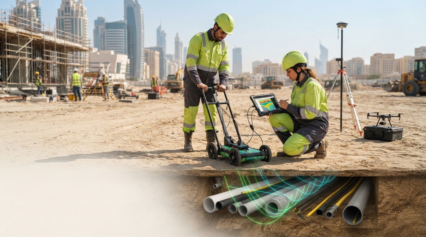
For teams researching underground utility mapping in Dubai and the UAE, the key question is how to turn subsurface information into decisions about design and excavation. A useful survey is not simply one that records the most signals. It is one scoped around the project’s target assets, work area, and intended use of the findings. GEOTECH 3D provides Utility Mapping (GPR) within GIS & Surveying Services in Dubai and the UAE; this guide explains practical considerations for local project teams and other readers assessing a GPR-led approach.
It is reasonable to seek better information about the location and type of buried utilities before work begins. Ground Penetrating Radar (GPR) can identify subsurface responses and support utility mapping, but results depend on site conditions and must be interpreted with appropriate limits in mind. The survey scope should reflect the site, project stage, and decisions the information is intended to support.
This guide covers how GPR-led utility mapping works, what information it can provide, and how to define useful deliverables for design coordination and excavation planning. It also explains how GEOTECH 3D’s Utility Mapping (GPR) and GIS & Surveying Services support project-focused utility information for work in Dubai and across the UAE.
Key Takeaways
- Plan underground utility mapping around the design, maintenance, and excavation decisions the project needs to make.
- Build a GPR-led survey scope from project objectives through record review, fieldwork, interpretation, and delivery.
- Set realistic expectations: GPR is one detection method, and findings depend on target assets and site conditions.
- Define the survey boundary, target utilities, available records, access conditions, and coordination needs before fieldwork.
- GEOTECH 3D provides Utility Mapping (GPR) within GIS & Surveying Services in Dubai and the UAE.
What Underground Utility Mapping in Saudi Arabia Can Tell a Project Team
Underground utility mapping gathers and organizes spatial information about buried assets so teams can assess their relationship to proposed work. In underground utility mapping Saudi Arabia projects, the value is not simply marking lines on a plan. Teams also need to understand what each line represents, where the information came from, and how confidently it can support a decision.
Utility Mapping (GPR) uses ground-penetrating radar to collect subsurface response data and help identify and map possible buried utility routes. GPR observations need interpretation in context. They do not guarantee that every asset will be detected, and a response alone may not establish an asset’s exact type. The Ground-penetrating radar (GPR) overview explains the method’s principles and applications.
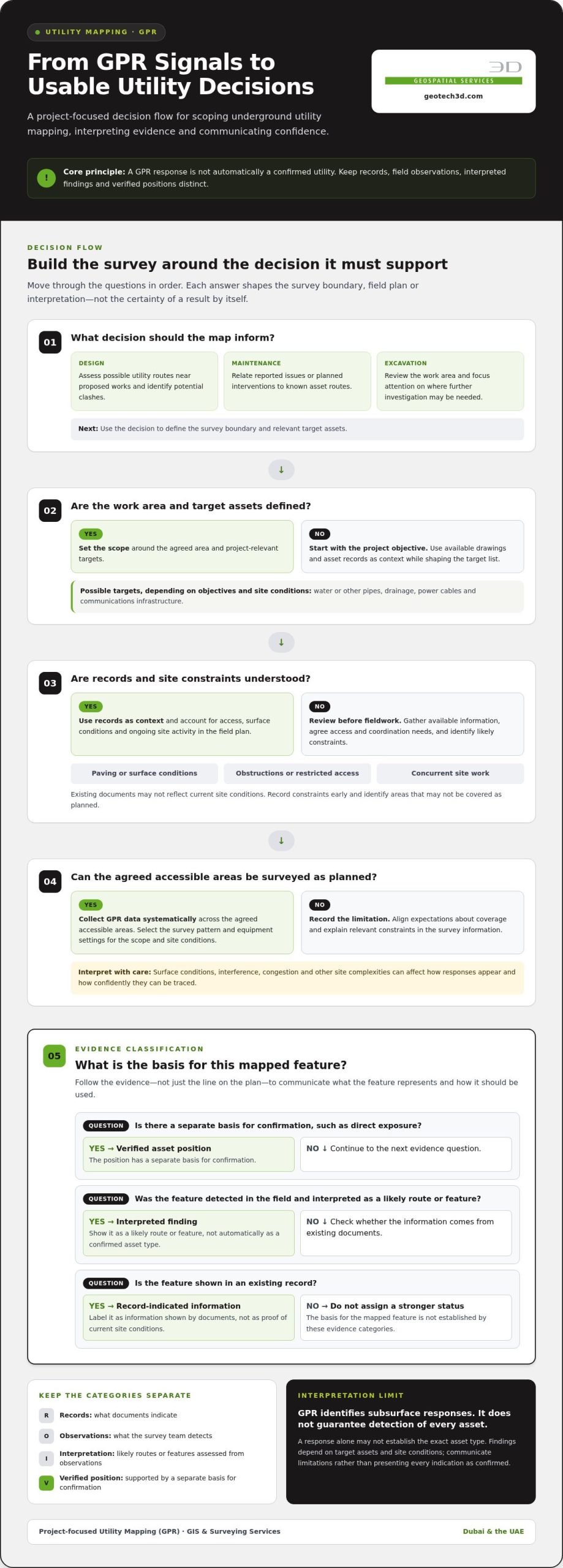
Keep the evidence behind each mapped feature clear. Existing records show what documents indicate, but may not reflect current site conditions. Field observations record what the survey team detects at the site. Interpreted findings connect those observations into likely routes or features. A verified asset position has a separate basis for confirmation, such as direct exposure. These categories are not interchangeable, so the map and accompanying information should make their status clear.
Which buried assets may be relevant to a survey?
Depending on the project objectives and site conditions, the target list may include water or other pipes, drainage, power cables, and communications infrastructure. A detected response may indicate a possible route without confirming whether it is a pipe, cable, redundant asset, or another buried feature. Mapping should distinguish these indications from confirmed asset information so designers and construction teams can use the findings appropriately.
Set survey targets according to the decisions the project needs to make. For a building extension, the team may focus on assets crossing the proposed footprint and connection routes. A road or infrastructure corridor may require a broader view of utilities near the planned works. Existing records can help shape the target list, while gaps or conflicting details can flag areas that need careful interpretation.
Why mapping matters before design or excavation
Buried assets occupy space that proposed foundations, service connections, access routes, and temporary works may also need. Bringing available utility information into the project’s spatial context helps designers and coordinators identify potential clashes, consider alternatives, and focus follow-up investigation. It also gives construction teams a clearer basis for planning where excavation needs particular attention.
For maintenance planning, mapped information can help teams relate reported issues or planned interventions to known asset routes. Before excavation, it can inform reviews of work areas and decisions about investigation and sequencing. Mapping does not remove uncertainty or guarantee that damage, incidents, or delays will be avoided. Its value is making available evidence easier to review and use.
A useful map communicates both location and confidence. When records, observations, interpreted routes, and verified positions are clearly distinguished, project teams can coordinate design and field decisions without treating every mapped line as equally certain.
How GPR Utility Mapping Works on a Saudi Project
A sound GPR mapping workflow starts with the decisions the survey needs to support, not with a preset field pattern. For underground utility mapping Saudi Arabia projects, connect the site information, field activities, interpretation, and deliverables to a defined design, maintenance, or excavation need. This gives the project team a practical basis for reviewing and applying the findings.
Set objectives and prepare the survey area
First, identify the work area and the decision the map must inform. A design team may need to assess potential utility routes near proposed works; a maintenance team may have a specific asset area in focus. Gather available drawings and asset records as useful context, not as proof of current site conditions. Then define the survey boundary and agree access arrangements and coordination needs with the project team.
Preparation should account for the survey surface and ongoing site activity. Paving, obstructions, restricted access, or concurrent work may affect where and how field data can be collected. Record these constraints early to align expectations and identify any areas that may not be covered as planned.
Acquire and interpret GPR observations
During fieldwork, the survey team collects GPR data systematically across the agreed accessible areas. The survey pattern and equipment settings are selected for the project scope and site conditions; no single grid or frequency suits every site. GPR records responses from below the surface, which are then reviewed and interpreted to identify features that may represent utility routes.
Interpretation is a reasoned assessment, not a direct label attached to every signal. Surface conditions, interference, congestion, and other site complexities can affect how responses appear and how confidently they can be traced. The final mapping should distinguish observations from interpreted features and communicate relevant limitations, rather than presenting every indication as a confirmed asset.
In practical terms, the sequence is to define the project question, review records, set survey limits and access arrangements, collect field data, interpret responses in context, and prepare the agreed mapping deliverables. Each stage informs the next. If the survey question or site conditions change, revisit the scope so the results remain aligned with the decision they are intended to support.
At handover, the project team needs clear spatial information and an explanation of how it was derived. Agree an output that identifies mapped features in a form the team can review alongside project drawings and other survey information. GEOTECH 3D’s GIS & Surveying Services include Utility Mapping (GPR) for project-focused mapping as part of a surveying workflow in Dubai and the UAE.
GPR, Other Detection Methods, and the Limits of Utility Mapping
No single detection approach answers every subsurface question. For underground utility mapping Saudi Arabia projects, choose methods in light of the project objective, target asset, surface and site conditions, and information already available. GPR is one tool in that decision, not a guarantee that every buried asset will be located.
The comparison below is a general guide, not a specification for a particular site. Suitability depends on project-specific evidence, access, and survey scope.
| Approach | Potential role | Project-specific consideration |
|---|---|---|
| Ground-penetrating radar (GPR) | Collects subsurface response data that can be interpreted to map potential features. | Surface conditions, interference, and complex underground environments can affect observations and interpretation. |
| Radio-frequency locating | May assist with tracing a target when it can be located using this approach. | Suitability depends on the target asset and the available information; it should not be assumed to address every buried feature. |
| Acoustic detection | May be considered for some project objectives and asset types. | Its relevance depends on the target, site conditions, and what the survey needs to establish. |
When project teams consider complementary detection approaches
For example, a team investigating a possible route near a proposed excavation can consider whether GPR observations answer the project question or whether another approach could add relevant evidence. Radio-frequency locating and acoustic detection are examples of methods used in the wider utility-survey field, not universal add-ons. The appropriate choice depends on the asset sought, site context, and agreed objective. Avoid selecting a combination before those factors have been assessed.
What mapping results can and cannot establish
A recorded response is an observation. An interpreted utility feature is an assessment of what that response may represent. Neither automatically confirms the asset’s identity, material, condition, or exact position. Independent verification requires an appropriate basis beyond interpretation, and the method used to establish it should be clear to the project team.
This distinction helps engineers and construction teams use evidence proportionately. An interpreted route can inform coordination and indicate where further investigation may be useful, while a confirmed position can support a different level of decision-making. Treating those evidence levels as equivalent can create misplaced confidence.
Record project-specific assumptions with the findings. These may include which assets were targeted, what areas were accessible, which records informed interpretation, and where site conditions limited observations. Deliverables should communicate mapped indications, confidence, and relevant limitations clearly, so designers and excavation planners can judge how the information applies to their work.
Choose the survey approach by matching the project question to the target and site, then state what the resulting evidence does and does not establish. This provides a more dependable basis for coordination than treating any one detection method as a complete inventory of everything underground.
How to Scope Utility Mapping for a Saudi Infrastructure Project
A project-ready scope turns a general request to “locate utilities” into a defined survey brief. For underground utility mapping Saudi Arabia projects, agree what decisions the information must support, which areas and assets are in scope, and how the findings will be delivered. This helps the survey team focus fieldwork and gives designers and construction teams a clear basis for using the results.
Use this checklist to structure the brief:
- Project decisions: Identify whether the mapping will inform design coordination, maintenance planning, investigation, or excavation planning. Name the intended users, such as the design team, site team, or asset owner.
- Survey boundary: Define the work area and any adjoining zones that matter to the planned works. Provide site boundaries or drawings that make the limits clear.
- Target assets: List the utility types relevant to the project, such as drainage, pipes, power, or communications infrastructure. Prioritise targets where the project has specific concerns.
- Existing information: Assemble available utility records, drawings, and prior survey information. Identify gaps, inconsistent details, and areas where records may not reflect current site conditions.
- Field constraints: Describe access conditions, surface types, obstructions, active works, and coordination requirements. Note areas where access may be restricted or survey activity needs to be planned around other site operations.
Information to assemble before fieldwork
Bring together boundary information, records, drawings, and project constraints before field planning begins. Clarify who will use the mapping and which decisions it must support. Record known uncertainties, priority areas, and stakeholder coordination needs, including site access arrangements. This preparation helps the survey scope reflect working conditions rather than relying on assumptions formed from drawings alone.
Agreeing useful mapping outputs
Specify how the project team needs to review and share the findings. Agree the required spatial format, level of detail, and relationship to project drawings or other survey information. Keep observations, interpreted features, and source records distinguishable. The handover should also state relevant assumptions, access limitations, and interpretation constraints so users understand how to apply the information.
Keep requirements specific to the project. Access, data handling, and regulatory or contractual requirements can vary by site and contract, so establish the requirements that apply to the work with the relevant project stakeholders before fieldwork. Do not assume a requirement from another project automatically applies. A clear scope records what has been agreed and what the mapping is intended to support.
GEOTECH 3D provides Utility Mapping (GPR) within GIS & Surveying Services in Dubai and the UAE. The scope is based on the project’s defined information needs and survey constraints.
GEOTECH 3D Utility Mapping (GPR) for Saudi Project Teams
Utility mapping is most useful when field observations connect to the spatial information used for planning and coordination. GEOTECH 3D provides Utility Mapping (GPR) within GIS & Surveying Services in Dubai and the UAE. The service is relevant to utilities and infrastructure owners, as well as project teams that need subsurface information to inform design, maintenance, or excavation decisions.
For any project, shape the scope around the question the mapping needs to answer. A design team may need information about potential utility routes in a proposed work area; an asset owner may be planning maintenance or future works. Agreeing the intended use, survey boundary, target assets, and available records helps define a project-specific approach. It also gives the team a clear basis for deciding how findings should be organized and shared.
A GIS and surveying perspective on buried assets
Utility mapping fits within a broader spatial information workflow. Organizing mapped features with their source and interpretation context helps project teams review subsurface information alongside other survey and design data. This makes it easier to understand how the information relates to planned works, while keeping observed responses distinct from interpreted features and existing records. For background on the wider discipline, explore a GIS and surveying services approach to spatial project information.
Clear data organization supports communication across disciplines. Engineers can consider mapped routes during design coordination, while construction teams can use the information as one input to excavation planning. Asset owners can also retain a structured spatial view for future planning. Read the map according to the evidence it contains, not as assurance that every buried asset has been identified or independently verified.
For teams working in Dubai and the UAE, GEOTECH 3D’s Utility Mapping (GPR) can be scoped as part of its GIS & Surveying Services. Bring the intended decisions, survey boundary, available utility records, target assets, and access considerations into the initial scope discussion. These inputs help connect the mapping brief to the practical needs of design, maintenance, or excavation planning.
Discuss your project objectives and Utility Mapping (GPR) scope with GEOTECH 3D.
Turn Utility Information into a Stronger Project Brief
Survey handover can mark the start of ongoing information management, not the end of the mapping task. As project plans evolve, assign responsibility for recording relevant revisions and new field findings alongside current spatial information. This gives later decision-makers context about which information informed earlier choices. For underground utility mapping Saudi Arabia projects, maintaining that continuity can help teams carry subsurface context forward as project requirements develop.
Consider how your team will manage updates between design and construction stages, and include that responsibility in project coordination.
With clear ownership of information updates, your team can carry valuable project context into the next stage. For Utility Mapping (GPR) in Dubai and the UAE, discuss your project scope with GEOTECH 3D.
Frequently Asked Questions
What is underground utility mapping?
Underground utility mapping creates a location-based record of buried infrastructure relevant to a site or planned work. It helps teams relate possible utility routes to features such as building footprints, road alignments, and proposed service connections. A useful record also distinguishes information from existing documentation from survey interpretation, so users can judge how it applies to a particular decision.
How does GPR utility mapping work?
GPR sends electromagnetic energy into the ground and records returning responses from changes in subsurface materials. A survey team reviews those responses to interpret potential buried features and map their likely routes. The resulting information is considered alongside project records and site context. GPR does not identify every response automatically, so interpretation and clear communication of findings are important parts of the process.
Can GPR locate every underground pipe or cable?
No. GPR cannot be relied on to find every buried pipe or cable. Detection and interpretation can be affected by the asset, ground and surface conditions, interference, and site complexity. A survey may map useful indications without establishing the full network or confirming each asset’s identity. Treat the results as evidence for planning, not as a guarantee that an excavation area is clear.
What information should I provide before a utility mapping survey?
Provide the survey area, planned work footprint, available utility drawings, and the project decision the mapping should support. Identify priority assets or locations, such as a proposed connection corridor or foundation area. Include drawing revisions and coordinate information if available, along with access restrictions, active site operations, and relevant coordination contacts. These details help shape a focused brief and clarify where records may be incomplete.
How are underground utility mapping results delivered?
Results are prepared according to the agreed project scope and handover needs. Specify how the team needs to review and share mapped information, including the spatial format, level of detail, and relationship to project drawings. The handover should make the status of mapped features understandable and include relevant assumptions or limitations. Agreeing these requirements in advance helps designers and construction teams use the information in their workflows.
Is underground utility mapping required before excavation in Saudi Arabia?
Whether underground utility mapping Saudi Arabia projects require a survey before excavation depends on the project’s applicable requirements, permit conditions, contract, and site arrangements. GPR should not be assumed to be a universal legal requirement. Establish the requirements that apply to the work with the relevant project stakeholders and authorities before excavation planning proceeds.
Can existing utility drawings replace a GPR survey?
Existing drawings are useful reference information, but they may not show later changes, diversions, or differences between recorded and current site conditions. For example, a drawing issued before road or service works may not reflect subsequent modifications. Use available records to inform the survey brief and compare them with field findings. Whether further survey work is appropriate depends on the project decision and the information already available.
For teams researching underground utility mapping in Dubai and the UAE, the key question is how to turn subsurface information into decisions about design and excavation. A useful survey is not simply one that records the most signals. It is one scoped around the project’s target assets, work area, and intended use of the findings. GEOTECH 3D provides Utility Mapping (GPR) within GIS & Surveying Services in Dubai and the UAE; this guide explains practical considerations for local project teams and other readers assessing a GPR-led approach.
It is reasonable to seek better information about the location and type of buried utilities before work begins. Ground Penetrating Radar (GPR) can identify subsurface responses and support utility mapping, but results depend on site conditions and must be interpreted with appropriate limits in mind. The survey scope should reflect the site, project stage, and decisions the information is intended to support.
This guide covers how GPR-led utility mapping works, what information it can provide, and how to define useful deliverables for design coordination and excavation planning. It also explains how GEOTECH 3D’s Utility Mapping (GPR) and GIS & Surveying Services support project-focused utility information for work in Dubai and across the UAE.
Key Takeaways
- Plan underground utility mapping around the design, maintenance, and excavation decisions the project needs to make.
- Build a GPR-led survey scope from project objectives through record review, fieldwork, interpretation, and delivery.
- Set realistic expectations: GPR is one detection method, and findings depend on target assets and site conditions.
- Define the survey boundary, target utilities, available records, access conditions, and coordination needs before fieldwork.
- GEOTECH 3D provides Utility Mapping (GPR) within GIS & Surveying Services in Dubai and the UAE.
What Underground Utility Mapping in Saudi Arabia Can Tell a Project Team
Underground utility mapping gathers and organizes spatial information about buried assets so teams can assess their relationship to proposed work. In underground utility mapping Saudi Arabia projects, the value is not simply marking lines on a plan. Teams also need to understand what each line represents, where the information came from, and how confidently it can support a decision.
Utility Mapping (GPR) uses ground-penetrating radar to collect subsurface response data and help identify and map possible buried utility routes. GPR observations need interpretation in context. They do not guarantee that every asset will be detected, and a response alone may not establish an asset’s exact type. The Ground-penetrating radar (GPR) overview explains the method’s principles and applications.
Keep the evidence behind each mapped feature clear. Existing records show what documents indicate, but may not reflect current site conditions. Field observations record what the survey team detects at the site. Interpreted findings connect those observations into likely routes or features. A verified asset position has a separate basis for confirmation, such as direct exposure. These categories are not interchangeable, so the map and accompanying information should make their status clear.
Which buried assets may be relevant to a survey?
Depending on the project objectives and site conditions, the target list may include water or other pipes, drainage, power cables, and communications infrastructure. A detected response may indicate a possible route without confirming whether it is a pipe, cable, redundant asset, or another buried feature. Mapping should distinguish these indications from confirmed asset information so designers and construction teams can use the findings appropriately.
Set survey targets according to the decisions the project needs to make. For a building extension, the team may focus on assets crossing the proposed footprint and connection routes. A road or infrastructure corridor may require a broader view of utilities near the planned works. Existing records can help shape the target list, while gaps or conflicting details can flag areas that need careful interpretation.
Why mapping matters before design or excavation
Buried assets occupy space that proposed foundations, service connections, access routes, and temporary works may also need. Bringing available utility information into the project’s spatial context helps designers and coordinators identify potential clashes, consider alternatives, and focus follow-up investigation. It also gives construction teams a clearer basis for planning where excavation needs particular attention.
For maintenance planning, mapped information can help teams relate reported issues or planned interventions to known asset routes. Before excavation, it can inform reviews of work areas and decisions about investigation and sequencing. Mapping does not remove uncertainty or guarantee that damage, incidents, or delays will be avoided. Its value is making available evidence easier to review and use.
A useful map communicates both location and confidence. When records, observations, interpreted routes, and verified positions are clearly distinguished, project teams can coordinate design and field decisions without treating every mapped line as equally certain.
How GPR Utility Mapping Works on a Saudi Project
A sound GPR mapping workflow starts with the decisions the survey needs to support, not with a preset field pattern. For underground utility mapping Saudi Arabia projects, connect the site information, field activities, interpretation, and deliverables to a defined design, maintenance, or excavation need. This gives the project team a practical basis for reviewing and applying the findings.
Set objectives and prepare the survey area
First, identify the work area and the decision the map must inform. A design team may need to assess potential utility routes near proposed works; a maintenance team may have a specific asset area in focus. Gather available drawings and asset records as useful context, not as proof of current site conditions. Then define the survey boundary and agree access arrangements and coordination needs with the project team.
Preparation should account for the survey surface and ongoing site activity. Paving, obstructions, restricted access, or concurrent work may affect where and how field data can be collected. Record these constraints early to align expectations and identify any areas that may not be covered as planned.
Acquire and interpret GPR observations
During fieldwork, the survey team collects GPR data systematically across the agreed accessible areas. The survey pattern and equipment settings are selected for the project scope and site conditions; no single grid or frequency suits every site. GPR records responses from below the surface, which are then reviewed and interpreted to identify features that may represent utility routes.
Interpretation is a reasoned assessment, not a direct label attached to every signal. Surface conditions, interference, congestion, and other site complexities can affect how responses appear and how confidently they can be traced. The final mapping should distinguish observations from interpreted features and communicate relevant limitations, rather than presenting every indication as a confirmed asset.
In practical terms, the sequence is to define the project question, review records, set survey limits and access arrangements, collect field data, interpret responses in context, and prepare the agreed mapping deliverables. Each stage informs the next. If the survey question or site conditions change, revisit the scope so the results remain aligned with the decision they are intended to support.
At handover, the project team needs clear spatial information and an explanation of how it was derived. Agree an output that identifies mapped features in a form the team can review alongside project drawings and other survey information. GEOTECH 3D’s GIS & Surveying Services include Utility Mapping (GPR) for project-focused mapping as part of a surveying workflow in Dubai and the UAE.
GPR, Other Detection Methods, and the Limits of Utility Mapping
No single detection approach answers every subsurface question. For underground utility mapping Saudi Arabia projects, choose methods in light of the project objective, target asset, surface and site conditions, and information already available. GPR is one tool in that decision, not a guarantee that every buried asset will be located.
The comparison below is a general guide, not a specification for a particular site. Suitability depends on project-specific evidence, access, and survey scope.
| Approach | Potential role | Project-specific consideration |
|---|---|---|
| Ground-penetrating radar (GPR) | Collects subsurface response data that can be interpreted to map potential features. | Surface conditions, interference, and complex underground environments can affect observations and interpretation. |
| Radio-frequency locating | May assist with tracing a target when it can be located using this approach. | Suitability depends on the target asset and the available information; it should not be assumed to address every buried feature. |
| Acoustic detection | May be considered for some project objectives and asset types. | Its relevance depends on the target, site conditions, and what the survey needs to establish. |
When project teams consider complementary detection approaches
For example, a team investigating a possible route near a proposed excavation can consider whether GPR observations answer the project question or whether another approach could add relevant evidence. Radio-frequency locating and acoustic detection are examples of methods used in the wider utility-survey field, not universal add-ons. The appropriate choice depends on the asset sought, site context, and agreed objective. Avoid selecting a combination before those factors have been assessed.
What mapping results can and cannot establish
A recorded response is an observation. An interpreted utility feature is an assessment of what that response may represent. Neither automatically confirms the asset’s identity, material, condition, or exact position. Independent verification requires an appropriate basis beyond interpretation, and the method used to establish it should be clear to the project team.
This distinction helps engineers and construction teams use evidence proportionately. An interpreted route can inform coordination and indicate where further investigation may be useful, while a confirmed position can support a different level of decision-making. Treating those evidence levels as equivalent can create misplaced confidence.
Record project-specific assumptions with the findings. These may include which assets were targeted, what areas were accessible, which records informed interpretation, and where site conditions limited observations. Deliverables should communicate mapped indications, confidence, and relevant limitations clearly, so designers and excavation planners can judge how the information applies to their work.
Choose the survey approach by matching the project question to the target and site, then state what the resulting evidence does and does not establish. This provides a more dependable basis for coordination than treating any one detection method as a complete inventory of everything underground.
How to Scope Utility Mapping for a Saudi Infrastructure Project
A project-ready scope turns a general request to “locate utilities” into a defined survey brief. For underground utility mapping Saudi Arabia projects, agree what decisions the information must support, which areas and assets are in scope, and how the findings will be delivered. This helps the survey team focus fieldwork and gives designers and construction teams a clear basis for using the results.
Use this checklist to structure the brief:
- Project decisions: Identify whether the mapping will inform design coordination, maintenance planning, investigation, or excavation planning. Name the intended users, such as the design team, site team, or asset owner.
- Survey boundary: Define the work area and any adjoining zones that matter to the planned works. Provide site boundaries or drawings that make the limits clear.
- Target assets: List the utility types relevant to the project, such as drainage, pipes, power, or communications infrastructure. Prioritise targets where the project has specific concerns.
- Existing information: Assemble available utility records, drawings, and prior survey information. Identify gaps, inconsistent details, and areas where records may not reflect current site conditions.
- Field constraints: Describe access conditions, surface types, obstructions, active works, and coordination requirements. Note areas where access may be restricted or survey activity needs to be planned around other site operations.
Information to assemble before fieldwork
Bring together boundary information, records, drawings, and project constraints before field planning begins. Clarify who will use the mapping and which decisions it must support. Record known uncertainties, priority areas, and stakeholder coordination needs, including site access arrangements. This preparation helps the survey scope reflect working conditions rather than relying on assumptions formed from drawings alone.
Agreeing useful mapping outputs
Specify how the project team needs to review and share the findings. Agree the required spatial format, level of detail, and relationship to project drawings or other survey information. Keep observations, interpreted features, and source records distinguishable. The handover should also state relevant assumptions, access limitations, and interpretation constraints so users understand how to apply the information.
Keep requirements specific to the project. Access, data handling, and regulatory or contractual requirements can vary by site and contract, so establish the requirements that apply to the work with the relevant project stakeholders before fieldwork. Do not assume a requirement from another project automatically applies. A clear scope records what has been agreed and what the mapping is intended to support.
GEOTECH 3D provides Utility Mapping (GPR) within GIS & Surveying Services in Dubai and the UAE. The scope is based on the project’s defined information needs and survey constraints.
GEOTECH 3D Utility Mapping (GPR) for Saudi Project Teams
Utility mapping is most useful when field observations connect to the spatial information used for planning and coordination. GEOTECH 3D provides Utility Mapping (GPR) within GIS & Surveying Services in Dubai and the UAE. The service is relevant to utilities and infrastructure owners, as well as project teams that need subsurface information to inform design, maintenance, or excavation decisions.
For any project, shape the scope around the question the mapping needs to answer. A design team may need information about potential utility routes in a proposed work area; an asset owner may be planning maintenance or future works. Agreeing the intended use, survey boundary, target assets, and available records helps define a project-specific approach. It also gives the team a clear basis for deciding how findings should be organized and shared.
A GIS and surveying perspective on buried assets
Utility mapping fits within a broader spatial information workflow. Organizing mapped features with their source and interpretation context helps project teams review subsurface information alongside other survey and design data. This makes it easier to understand how the information relates to planned works, while keeping observed responses distinct from interpreted features and existing records. For background on the wider discipline, explore a GIS and surveying services approach to spatial project information.
Clear data organization supports communication across disciplines. Engineers can consider mapped routes during design coordination, while construction teams can use the information as one input to excavation planning. Asset owners can also retain a structured spatial view for future planning. Read the map according to the evidence it contains, not as assurance that every buried asset has been identified or independently verified.
For teams working in Dubai and the UAE, GEOTECH 3D’s Utility Mapping (GPR) can be scoped as part of its GIS & Surveying Services. Bring the intended decisions, survey boundary, available utility records, target assets, and access considerations into the initial scope discussion. These inputs help connect the mapping brief to the practical needs of design, maintenance, or excavation planning.
Discuss your project objectives and Utility Mapping (GPR) scope with GEOTECH 3D.
Turn Utility Information into a Stronger Project Brief
Survey handover can mark the start of ongoing information management, not the end of the mapping task. As project plans evolve, assign responsibility for recording relevant revisions and new field findings alongside current spatial information. This gives later decision-makers context about which information informed earlier choices. For underground utility mapping Saudi Arabia projects, maintaining that continuity can help teams carry subsurface context forward as project requirements develop.
Consider how your team will manage updates between design and construction stages, and include that responsibility in project coordination.
With clear ownership of information updates, your team can carry valuable project context into the next stage. For Utility Mapping (GPR) in Dubai and the UAE, discuss your project scope with GEOTECH 3D.
Frequently Asked Questions
What is underground utility mapping?
Underground utility mapping creates a location-based record of buried infrastructure relevant to a site or planned work. It helps teams relate possible utility routes to features such as building footprints, road alignments, and proposed service connections. A useful record also distinguishes information from existing documentation from survey interpretation, so users can judge how it applies to a particular decision.
How does GPR utility mapping work?
GPR sends electromagnetic energy into the ground and records returning responses from changes in subsurface materials. A survey team reviews those responses to interpret potential buried features and map their likely routes. The resulting information is considered alongside project records and site context. GPR does not identify every response automatically, so interpretation and clear communication of findings are important parts of the process.
Can GPR locate every underground pipe or cable?
No. GPR cannot be relied on to find every buried pipe or cable. Detection and interpretation can be affected by the asset, ground and surface conditions, interference, and site complexity. A survey may map useful indications without establishing the full network or confirming each asset’s identity. Treat the results as evidence for planning, not as a guarantee that an excavation area is clear.
What information should I provide before a utility mapping survey?
Provide the survey area, planned work footprint, available utility drawings, and the project decision the mapping should support. Identify priority assets or locations, such as a proposed connection corridor or foundation area. Include drawing revisions and coordinate information if available, along with access restrictions, active site operations, and relevant coordination contacts. These details help shape a focused brief and clarify where records may be incomplete.
How are underground utility mapping results delivered?
Results are prepared according to the agreed project scope and handover needs. Specify how the team needs to review and share mapped information, including the spatial format, level of detail, and relationship to project drawings. The handover should make the status of mapped features understandable and include relevant assumptions or limitations. Agreeing these requirements in advance helps designers and construction teams use the information in their workflows.
Is underground utility mapping required before excavation in Saudi Arabia?
Whether underground utility mapping Saudi Arabia projects require a survey before excavation depends on the project’s applicable requirements, permit conditions, contract, and site arrangements. GPR should not be assumed to be a universal legal requirement. Establish the requirements that apply to the work with the relevant project stakeholders and authorities before excavation planning proceeds.
Can existing utility drawings replace a GPR survey?
Existing drawings are useful reference information, but they may not show later changes, diversions, or differences between recorded and current site conditions. For example, a drawing issued before road or service works may not reflect subsequent modifications. Use available records to inform the survey brief and compare them with field findings. Whether further survey work is appropriate depends on the project decision and the information already available.
Search Now
Error: Contact form not found.