

Our Services
Volumetric Survey Using UAV: Guide for Dubai Projects
Can a UAV deliver dependable volume data for a Dubai stockpile or construction site? It can when aerial capture is supported by suitable survey control, careful surface interpretation, and reporting matched to the project. A volumetric survey using UAV is more than a set of aerial images: the images are processed into mapped surfaces that can be compared and analysed to calculate quantities.
It is reasonable to ask how reliable the result will be when vegetation obscures the ground, access is restricted, or site conditions change between surveys. The calculation depends on how the survey is planned, which surface is captured, and how the measurement boundary and reference surface are defined.
This guide explains the workflow from aerial data capture to volume reporting and outlines site conditions that can affect data quality and interpretation. It also covers how to define useful outputs, such as cut-and-fill calculations or stockpile volumes, before commissioning a survey. GEOTECH 3D provides Drone Services, including Aerial Survey and Point-cloud Survey, alongside GIS & Surveying Services and Volumetric Mining Surveys for project requirements across Dubai and the UAE.
Key Takeaways
- A volume result depends on defining the measurement boundary and reference surface before data capture begins.
- A volumetric survey using UAV turns captured site data into a model and calculation, with each stage influencing how the result is interpreted.
- Vegetation, access constraints, and changing site conditions can affect what the survey captures and how suitable the data is for a project decision.
- Set the survey scope by identifying the purpose, required surfaces, available reference data, and expected report outputs.
- GEOTECH 3D provides Aerial Survey and Point-cloud Survey alongside Volumetric Mining Surveys and Digital Photogrammetry Services for Dubai and UAE projects.
What a volumetric survey using UAV measures on a project site
A volumetric survey measures the quantity of material or space between a surveyed surface and a defined reference surface. The result depends on both: the captured surface describes the site at the time of the survey, while the reference surface provides the basis for comparison.
A UAV volumetric survey measures the volume between a mapped site surface and an agreed base or comparison surface within a defined boundary. Agree on the boundary, the surface to be measured, and the purpose of the calculation before capture. For example, a stockpile calculation may use the ground beneath the material as its base. An excavation calculation may compare the current surface with a design or earlier surface, depending on the project question.
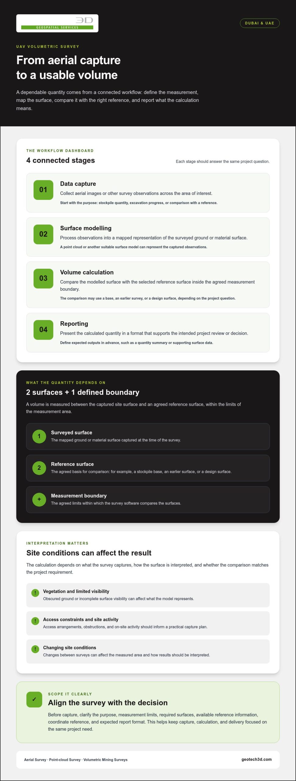
Four tasks contribute to a useful result, but they are not interchangeable:
- Data capture: Aerial images or other survey observations are collected across the area of interest.
- Surface modelling: The processed observations represent the surveyed ground or material surface, potentially as a point cloud or another surface model.
- Volume calculation: Survey software compares the modelled surface with the selected reference surface inside the defined boundary.
- Reporting: The calculated quantity is presented in a format that supports the project’s intended review or decision.
How UAV survey data becomes a volume calculation
In an image-based workflow, overlapping aerial images provide observations for photogrammetric processing. The resulting mapped surface can then be compared with a defined base or another survey surface to calculate the difference in volume. For background on the capture method, see this Unmanned aerial photogrammetric survey overview. The calculation is meaningful only when the comparison surface and measurement limits match the project requirement.
Where volumetric surveys support Dubai and UAE projects
Stockpiles and mining operations are direct applications: measurements can help teams understand material quantities within agreed limits. GEOTECH 3D provides Volumetric Mining Surveys as part of its wider GIS & Surveying Services. On construction projects, measured excavation and fill volumes can inform planning and quantity reviews. The appropriate comparison surface depends on whether the team needs a current quantity, a change measurement, or a comparison against a defined design surface.
For Dubai and UAE projects, defining the purpose early helps align the survey boundary, captured surface, calculation, and report. GEOTECH 3D provides Drone Services, including Aerial Survey and Point-cloud Survey, as well as Digital Photogrammetry Services for aerial data capture and survey-focused analysis.
How a UAV volumetric survey moves from site planning to a report
A dependable workflow starts with the project question, not the flight. Is the team measuring a stockpile, checking excavation progress, or comparing earthworks against a reference surface? The answer determines the survey boundary, the surfaces needed for comparison, and the form of the final report.
A UAV volume survey moves from a defined measurement question to planned data capture, surface processing, checked calculations, and reporting. Each stage should serve the same purpose. If the boundary or comparison surface is unclear, the resulting quantity may not answer the project team’s actual question.
Define the survey scope before UAV data capture
Before capture, identify the material or area to measure and agree on the limits using a plan or another clear reference. Specify whether the calculation needs a base surface, a previous survey, or a design surface for comparison. Also define the intended use and expected report format, such as a quantity summary or supporting surface data. Current drawings and reference information can help establish these requirements.
Planning should account for access, obstructions, surface visibility, and site activity that could affect safe capture or change the measured area. In Dubai and across the UAE, project teams should communicate access arrangements and coordinate the survey area with relevant on-site personnel. These details help shape a practical capture plan around the conditions at each site.
Process survey data into surfaces and volume outputs
After capture, the observations are processed into a surface representation suitable for the agreed calculation. Before measuring, the survey team can review the defined boundary, identify gaps or outliers, and assess whether the model represents the material or ground surface required. This review matters where obstructions or incomplete visibility affect interpretation.
The measured surface and the reference surface are distinct inputs. The current survey represents captured observations; a base or design surface may come from supplied project data or an agreed modelling assumption. The scope should make that distinction clear, alongside the required coordinate reference and delivery formats, so users can understand what the reported quantity compares.
For a volumetric survey using UAV, capture, processing, calculation, and delivery should be planned as connected steps. A practical sequence is:
- Define the measurement question and area boundary.
- Agree on the comparison surface, intended use, and reporting requirements.
- Plan site access and capture around visibility and active work areas.
- Process and review the surface before calculating the volume.
- Deliver the agreed outputs with the comparison basis clearly stated.
GEOTECH 3D provides Drone Services and GIS & Surveying Services for survey requirements across Dubai and the UAE. To explore the service range, visit GEOTECH 3D surveying services.
Can UAV volumetric surveys be reliable enough for project decisions?
Yes, a UAV survey can support project decisions when the capture method, site conditions, validation approach, and required tolerance suit the intended use. Reliability is not a fixed property of the aircraft or software. It depends on whether the data represents the relevant surface and whether the resulting volume is suitable for the decision being made.
UAV capture can provide broad coverage of an accessible, visible area. Ground-based survey methods can provide observations at selected locations or where detailed checks are needed. Neither method is automatically preferable. For a stockpile with a clear surface, aerial data may cover much of the measurement area. Where material is hidden behind structures or the ground is obscured, additional observations or a different approach may be needed.
What influences UAV volume survey data quality?
Surface visibility is central. Aerial observations represent what can be captured, so concealed areas beneath vegetation, structures, equipment, or overhanging material may not represent the surface required for the calculation. Unclear boundaries can also change the quantity being measured. If conditions shift between capture and comparison, apparent volume differences may reflect site changes as well as measurement differences.
Repeat surveys rely on consistent reference information, boundaries, and comparison methods. Set the required tolerance according to the project decision rather than assuming it from a general accuracy claim. Plan validation to address that requirement and the relevant site limitations.
When to compare UAV data with other survey methods
Consider UAV capture when aerial coverage can represent the defined area and required surface. Ground-based observations may complement it when the scope calls for additional checks, detail in obstructed areas, or verification of selected features. Combining methods can be appropriate, but the choice depends on the site and intended output.
Use the questions below to make reliability requirements clear in the scope:
| Project condition | Scope question |
|---|---|
| Partly hidden surface | Which areas may need additional observations or separate interpretation? |
| Uncertain boundary | What drawing or reference defines the calculation limit? |
| Changing site conditions | When should capture occur, and what surface will serve as the comparison? |
| Defined decision tolerance | What verification approach is appropriate for the intended use? |
| Required project outputs | Which surface data and volume report formats are needed? |
A volumetric survey using UAV is fit for a project decision when its limitations are understood and its validation aligns with the intended use. GEOTECH 3D provides Drone Services and GIS & Surveying Services for survey requirements across Dubai and the UAE, with the scope shaped around project conditions and deliverables.
How to prepare a Dubai site for a UAV volumetric survey
Good preparation helps the survey answer a defined project question. Before scheduling a volumetric survey using UAV, align the project team on what must be measured, which area is included, and how the resulting information will be used. Current site drawings, design surfaces, or previous survey data can help clarify the scope when available.
Information to define before the survey date
Describe the feature to measure, such as a stockpile, excavation, or earthworks area, and state the volume question the team needs answered. Identify the survey boundary and the surface that will serve as the comparison. If the project has coordinate requirements, include them in the scope so the data can be prepared for its intended use.
Also clarify who will use the results and what they need to receive. A project manager may need a concise volume summary, while a technical team may also require surface or point-cloud data. These are scope decisions, not automatic outputs, so define them before capture.
Coordinate access and site activity with the relevant project personnel. Share known obstructions, active work areas, access restrictions, and safe locations for survey operations. This helps the survey plan reflect actual site conditions and supports clear communication with workers during field activity.
Planning repeat surveys and useful deliverables
For monitoring change over time, keep survey boundaries and reference-surface definitions consistent between visits. If the limits or comparison basis change, differences in calculated volume may not represent site change alone. Record the basis used for each measurement so the project team can interpret comparisons properly.
Depending on the agreed scope, deliverables may include point-cloud data, a surface model, or a volume summary. Specify the required formats, coordinate reference, and intended recipients in advance. Where drawings or reference data are supplied, identify the relevant version and how it should inform the survey boundary or comparison surface.
Planning checklist: define the volume question, mark the boundary, identify the comparison surface, share site access and safety constraints, and specify the required outputs.
GEOTECH 3D provides Drone Services and GIS & Surveying Services for volumetric survey requirements on projects in Dubai and across the UAE. A clear scope connects aerial capture with useful survey deliverables.
Plan a Dubai volumetric survey with GEOTECH 3D
A clear volume question gives the survey team a practical starting point. Whether your project concerns stockpiled material, mining quantities, or construction earthworks, the survey scope should connect the site area and surface to be measured with the decision the data needs to support. GEOTECH 3D works with project teams in Dubai and across the UAE to align survey requirements with data capture and reporting needs.
How GEOTECH 3D’s surveying services fit the requirement
Drone Services include Aerial Survey and Point-cloud Survey, supporting aerial data capture for the defined site and task. Within GIS & Surveying Services, Volumetric Mining Surveys address mining-related volume requirements, while Digital Photogrammetry Services support the processing of aerial imagery into survey data.
The suitable approach depends on the project scope: the measurement boundary, the surface to be represented, the reference surface for comparison, and the outputs required. Defining these elements helps shape the survey around its intended use rather than treating every site or volume question alike.
What to include in a project enquiry
To make an initial discussion useful, share the information available about:
- Site location and boundary: Identify the Dubai or UAE project area and provide a drawing or clear boundary reference where available.
- Material or feature: Describe the stockpile, mining area, excavation, or earthworks quantity to be measured.
- Purpose: Explain the decision the volume data will inform, such as a quantity review or comparison over time.
- Reference information: Note available site drawings, design surfaces, previous survey data, or other relevant project references.
- Deliverables: Specify the expected outputs, recipients, coordinate requirements, and required file formats.
- Repeat surveys: Indicate whether monitoring is planned so consistent boundaries and comparison surfaces can be considered.
These details help connect your requirements to the appropriate combination of Aerial Survey, Point-cloud Survey, Volumetric Mining Surveys, and Digital Photogrammetry Services. GEOTECH 3D provides volumetric survey using UAV services to address project scopes and intended deliverables.
Set Your Dubai Survey Scope with Confidence
A dependable volumetric survey using UAV starts with a clear measurement question, defined boundaries, and an agreed reference surface. Site visibility, access, changing conditions, and the intended use of the results all influence whether the survey approach is fit for purpose. Defining the required outputs early helps connect captured data to the decisions your project team needs to make.
For Dubai and UAE projects, GEOTECH 3D brings together Drone Services, including Aerial Survey and Point-cloud Survey, with GIS & Surveying Services. These include Volumetric Mining Surveys for relevant mining requirements. Share your site boundary, volume question, available reference information, and expected deliverables to give the survey scope a practical foundation.
With the right scope in place, your team can move forward with clearer expectations and survey information aligned to the project’s needs.
Frequently Asked Questions
What is a volumetric survey using a UAV?
A volumetric survey using a UAV measures the quantity of material or space between a surveyed surface and a defined reference surface within an agreed boundary. Aerial data is processed into a surface representation, then compared with a base, design, or earlier surveyed surface as required. The calculation and report should reflect the project’s purpose, whether that is understanding a stockpile quantity or reviewing excavation progress.
How does a UAV calculate stockpile volume?
A UAV captures aerial observations of the stockpile and its visible surroundings. Processing turns those observations into a surface model, which is compared with a defined base surface inside the agreed measurement boundary. The software calculates the difference between the surfaces. The chosen boundary and base matter: if they do not represent the stockpile limits and intended calculation, the reported quantity may not answer the project’s question.
Are UAV volumetric surveys accurate?
They can be suitable for project decisions when the capture plan, surface visibility, validation approach, and required tolerance align with the intended use. No single accuracy claim applies to every site or purpose. Obstructions, hidden surfaces, unclear boundaries, or changing conditions can affect interpretation. Before commissioning a survey, define the decision the data will support and the technical tolerance needed, then align validation and reporting with those requirements.
Can a UAV survey measure excavation and earthworks volumes?
Yes. UAV survey data can support excavation and earthworks volume calculations by representing the current visible surface and comparing it with an agreed reference, such as a design surface or earlier survey. The project scope should identify which area is included and which surface forms the comparison. Site access, obstructions, and incomplete visibility can affect whether additional survey observations are needed to represent the required area.
What information is needed before planning a UAV volumetric survey?
Provide the site location, measurement boundary, and description of the material or earthworks feature. Explain the volume question and intended decision, and identify the required comparison surface. Current drawings, design data, or earlier surveys can help define the scope when available. Include coordinate requirements, expected deliverables and formats, recipients, site access constraints, and whether the work involves repeat surveys.
How often should a stockpile or site be surveyed?
There is no universal survey interval. The appropriate timing depends on how quickly the stockpile or site may change and how frequently the project needs updated quantities or comparisons. Agree on a schedule around the operational or reporting decision, then keep the measurement boundary and reference-surface approach consistent between surveys. This helps the project team interpret changes in calculated volume over time.
What deliverables can a UAV volumetric survey provide?
Depending on the agreed scope, deliverables may include point-cloud data, a model of the surveyed surface, and a volume summary. The project team should specify the required formats, coordinate reference, and intended recipients before capture. GEOTECH 3D’s Drone Services include Aerial Survey and Point-cloud Survey, while GIS & Surveying Services include Volumetric Mining Surveys. Outputs are defined around the project requirement.
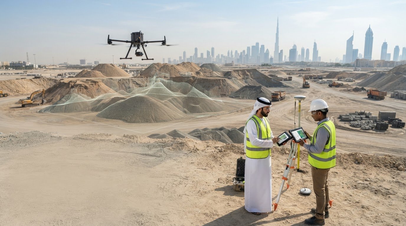
Can a UAV deliver dependable volume data for a Dubai stockpile or construction site? It can when aerial capture is supported by suitable survey control, careful surface interpretation, and reporting matched to the project. A volumetric survey using UAV is more than a set of aerial images: the images are processed into mapped surfaces that can be compared and analysed to calculate quantities.
It is reasonable to ask how reliable the result will be when vegetation obscures the ground, access is restricted, or site conditions change between surveys. The calculation depends on how the survey is planned, which surface is captured, and how the measurement boundary and reference surface are defined.
This guide explains the workflow from aerial data capture to volume reporting and outlines site conditions that can affect data quality and interpretation. It also covers how to define useful outputs, such as cut-and-fill calculations or stockpile volumes, before commissioning a survey. GEOTECH 3D provides Drone Services, including Aerial Survey and Point-cloud Survey, alongside GIS & Surveying Services and Volumetric Mining Surveys for project requirements across Dubai and the UAE.
Key Takeaways
- A volume result depends on defining the measurement boundary and reference surface before data capture begins.
- A volumetric survey using UAV turns captured site data into a model and calculation, with each stage influencing how the result is interpreted.
- Vegetation, access constraints, and changing site conditions can affect what the survey captures and how suitable the data is for a project decision.
- Set the survey scope by identifying the purpose, required surfaces, available reference data, and expected report outputs.
- GEOTECH 3D provides Aerial Survey and Point-cloud Survey alongside Volumetric Mining Surveys and Digital Photogrammetry Services for Dubai and UAE projects.
What a volumetric survey using UAV measures on a project site
A volumetric survey measures the quantity of material or space between a surveyed surface and a defined reference surface. The result depends on both: the captured surface describes the site at the time of the survey, while the reference surface provides the basis for comparison.
A UAV volumetric survey measures the volume between a mapped site surface and an agreed base or comparison surface within a defined boundary. Agree on the boundary, the surface to be measured, and the purpose of the calculation before capture. For example, a stockpile calculation may use the ground beneath the material as its base. An excavation calculation may compare the current surface with a design or earlier surface, depending on the project question.
Four tasks contribute to a useful result, but they are not interchangeable:
- Data capture: Aerial images or other survey observations are collected across the area of interest.
- Surface modelling: The processed observations represent the surveyed ground or material surface, potentially as a point cloud or another surface model.
- Volume calculation: Survey software compares the modelled surface with the selected reference surface inside the defined boundary.
- Reporting: The calculated quantity is presented in a format that supports the project’s intended review or decision.
How UAV survey data becomes a volume calculation
In an image-based workflow, overlapping aerial images provide observations for photogrammetric processing. The resulting mapped surface can then be compared with a defined base or another survey surface to calculate the difference in volume. For background on the capture method, see this Unmanned aerial photogrammetric survey overview. The calculation is meaningful only when the comparison surface and measurement limits match the project requirement.
Where volumetric surveys support Dubai and UAE projects
Stockpiles and mining operations are direct applications: measurements can help teams understand material quantities within agreed limits. GEOTECH 3D provides Volumetric Mining Surveys as part of its wider GIS & Surveying Services. On construction projects, measured excavation and fill volumes can inform planning and quantity reviews. The appropriate comparison surface depends on whether the team needs a current quantity, a change measurement, or a comparison against a defined design surface.
For Dubai and UAE projects, defining the purpose early helps align the survey boundary, captured surface, calculation, and report. GEOTECH 3D provides Drone Services, including Aerial Survey and Point-cloud Survey, as well as Digital Photogrammetry Services for aerial data capture and survey-focused analysis.
How a UAV volumetric survey moves from site planning to a report
A dependable workflow starts with the project question, not the flight. Is the team measuring a stockpile, checking excavation progress, or comparing earthworks against a reference surface? The answer determines the survey boundary, the surfaces needed for comparison, and the form of the final report.
A UAV volume survey moves from a defined measurement question to planned data capture, surface processing, checked calculations, and reporting. Each stage should serve the same purpose. If the boundary or comparison surface is unclear, the resulting quantity may not answer the project team’s actual question.
Define the survey scope before UAV data capture
Before capture, identify the material or area to measure and agree on the limits using a plan or another clear reference. Specify whether the calculation needs a base surface, a previous survey, or a design surface for comparison. Also define the intended use and expected report format, such as a quantity summary or supporting surface data. Current drawings and reference information can help establish these requirements.
Planning should account for access, obstructions, surface visibility, and site activity that could affect safe capture or change the measured area. In Dubai and across the UAE, project teams should communicate access arrangements and coordinate the survey area with relevant on-site personnel. These details help shape a practical capture plan around the conditions at each site.
Process survey data into surfaces and volume outputs
After capture, the observations are processed into a surface representation suitable for the agreed calculation. Before measuring, the survey team can review the defined boundary, identify gaps or outliers, and assess whether the model represents the material or ground surface required. This review matters where obstructions or incomplete visibility affect interpretation.
The measured surface and the reference surface are distinct inputs. The current survey represents captured observations; a base or design surface may come from supplied project data or an agreed modelling assumption. The scope should make that distinction clear, alongside the required coordinate reference and delivery formats, so users can understand what the reported quantity compares.
For a volumetric survey using UAV, capture, processing, calculation, and delivery should be planned as connected steps. A practical sequence is:
- Define the measurement question and area boundary.
- Agree on the comparison surface, intended use, and reporting requirements.
- Plan site access and capture around visibility and active work areas.
- Process and review the surface before calculating the volume.
- Deliver the agreed outputs with the comparison basis clearly stated.
GEOTECH 3D provides Drone Services and GIS & Surveying Services for survey requirements across Dubai and the UAE. To explore the service range, visit GEOTECH 3D surveying services.
Can UAV volumetric surveys be reliable enough for project decisions?
Yes, a UAV survey can support project decisions when the capture method, site conditions, validation approach, and required tolerance suit the intended use. Reliability is not a fixed property of the aircraft or software. It depends on whether the data represents the relevant surface and whether the resulting volume is suitable for the decision being made.
UAV capture can provide broad coverage of an accessible, visible area. Ground-based survey methods can provide observations at selected locations or where detailed checks are needed. Neither method is automatically preferable. For a stockpile with a clear surface, aerial data may cover much of the measurement area. Where material is hidden behind structures or the ground is obscured, additional observations or a different approach may be needed.
What influences UAV volume survey data quality?
Surface visibility is central. Aerial observations represent what can be captured, so concealed areas beneath vegetation, structures, equipment, or overhanging material may not represent the surface required for the calculation. Unclear boundaries can also change the quantity being measured. If conditions shift between capture and comparison, apparent volume differences may reflect site changes as well as measurement differences.
Repeat surveys rely on consistent reference information, boundaries, and comparison methods. Set the required tolerance according to the project decision rather than assuming it from a general accuracy claim. Plan validation to address that requirement and the relevant site limitations.
When to compare UAV data with other survey methods
Consider UAV capture when aerial coverage can represent the defined area and required surface. Ground-based observations may complement it when the scope calls for additional checks, detail in obstructed areas, or verification of selected features. Combining methods can be appropriate, but the choice depends on the site and intended output.
Use the questions below to make reliability requirements clear in the scope:
| Project condition | Scope question |
|---|---|
| Partly hidden surface | Which areas may need additional observations or separate interpretation? |
| Uncertain boundary | What drawing or reference defines the calculation limit? |
| Changing site conditions | When should capture occur, and what surface will serve as the comparison? |
| Defined decision tolerance | What verification approach is appropriate for the intended use? |
| Required project outputs | Which surface data and volume report formats are needed? |
A volumetric survey using UAV is fit for a project decision when its limitations are understood and its validation aligns with the intended use. GEOTECH 3D provides Drone Services and GIS & Surveying Services for survey requirements across Dubai and the UAE, with the scope shaped around project conditions and deliverables.
How to prepare a Dubai site for a UAV volumetric survey
Good preparation helps the survey answer a defined project question. Before scheduling a volumetric survey using UAV, align the project team on what must be measured, which area is included, and how the resulting information will be used. Current site drawings, design surfaces, or previous survey data can help clarify the scope when available.
Information to define before the survey date
Describe the feature to measure, such as a stockpile, excavation, or earthworks area, and state the volume question the team needs answered. Identify the survey boundary and the surface that will serve as the comparison. If the project has coordinate requirements, include them in the scope so the data can be prepared for its intended use.
Also clarify who will use the results and what they need to receive. A project manager may need a concise volume summary, while a technical team may also require surface or point-cloud data. These are scope decisions, not automatic outputs, so define them before capture.
Coordinate access and site activity with the relevant project personnel. Share known obstructions, active work areas, access restrictions, and safe locations for survey operations. This helps the survey plan reflect actual site conditions and supports clear communication with workers during field activity.
Planning repeat surveys and useful deliverables
For monitoring change over time, keep survey boundaries and reference-surface definitions consistent between visits. If the limits or comparison basis change, differences in calculated volume may not represent site change alone. Record the basis used for each measurement so the project team can interpret comparisons properly.
Depending on the agreed scope, deliverables may include point-cloud data, a surface model, or a volume summary. Specify the required formats, coordinate reference, and intended recipients in advance. Where drawings or reference data are supplied, identify the relevant version and how it should inform the survey boundary or comparison surface.
Planning checklist: define the volume question, mark the boundary, identify the comparison surface, share site access and safety constraints, and specify the required outputs.
GEOTECH 3D provides Drone Services and GIS & Surveying Services for volumetric survey requirements on projects in Dubai and across the UAE. A clear scope connects aerial capture with useful survey deliverables.
Plan a Dubai volumetric survey with GEOTECH 3D
A clear volume question gives the survey team a practical starting point. Whether your project concerns stockpiled material, mining quantities, or construction earthworks, the survey scope should connect the site area and surface to be measured with the decision the data needs to support. GEOTECH 3D works with project teams in Dubai and across the UAE to align survey requirements with data capture and reporting needs.
How GEOTECH 3D’s surveying services fit the requirement
Drone Services include Aerial Survey and Point-cloud Survey, supporting aerial data capture for the defined site and task. Within GIS & Surveying Services, Volumetric Mining Surveys address mining-related volume requirements, while Digital Photogrammetry Services support the processing of aerial imagery into survey data.
The suitable approach depends on the project scope: the measurement boundary, the surface to be represented, the reference surface for comparison, and the outputs required. Defining these elements helps shape the survey around its intended use rather than treating every site or volume question alike.
What to include in a project enquiry
To make an initial discussion useful, share the information available about:
- Site location and boundary: Identify the Dubai or UAE project area and provide a drawing or clear boundary reference where available.
- Material or feature: Describe the stockpile, mining area, excavation, or earthworks quantity to be measured.
- Purpose: Explain the decision the volume data will inform, such as a quantity review or comparison over time.
- Reference information: Note available site drawings, design surfaces, previous survey data, or other relevant project references.
- Deliverables: Specify the expected outputs, recipients, coordinate requirements, and required file formats.
- Repeat surveys: Indicate whether monitoring is planned so consistent boundaries and comparison surfaces can be considered.
These details help connect your requirements to the appropriate combination of Aerial Survey, Point-cloud Survey, Volumetric Mining Surveys, and Digital Photogrammetry Services. GEOTECH 3D provides volumetric survey using UAV services to address project scopes and intended deliverables.
Set Your Dubai Survey Scope with Confidence
A dependable volumetric survey using UAV starts with a clear measurement question, defined boundaries, and an agreed reference surface. Site visibility, access, changing conditions, and the intended use of the results all influence whether the survey approach is fit for purpose. Defining the required outputs early helps connect captured data to the decisions your project team needs to make.
For Dubai and UAE projects, GEOTECH 3D brings together Drone Services, including Aerial Survey and Point-cloud Survey, with GIS & Surveying Services. These include Volumetric Mining Surveys for relevant mining requirements. Share your site boundary, volume question, available reference information, and expected deliverables to give the survey scope a practical foundation.
With the right scope in place, your team can move forward with clearer expectations and survey information aligned to the project’s needs.
Frequently Asked Questions
What is a volumetric survey using a UAV?
A volumetric survey using a UAV measures the quantity of material or space between a surveyed surface and a defined reference surface within an agreed boundary. Aerial data is processed into a surface representation, then compared with a base, design, or earlier surveyed surface as required. The calculation and report should reflect the project’s purpose, whether that is understanding a stockpile quantity or reviewing excavation progress.
How does a UAV calculate stockpile volume?
A UAV captures aerial observations of the stockpile and its visible surroundings. Processing turns those observations into a surface model, which is compared with a defined base surface inside the agreed measurement boundary. The software calculates the difference between the surfaces. The chosen boundary and base matter: if they do not represent the stockpile limits and intended calculation, the reported quantity may not answer the project’s question.
Are UAV volumetric surveys accurate?
They can be suitable for project decisions when the capture plan, surface visibility, validation approach, and required tolerance align with the intended use. No single accuracy claim applies to every site or purpose. Obstructions, hidden surfaces, unclear boundaries, or changing conditions can affect interpretation. Before commissioning a survey, define the decision the data will support and the technical tolerance needed, then align validation and reporting with those requirements.
Can a UAV survey measure excavation and earthworks volumes?
Yes. UAV survey data can support excavation and earthworks volume calculations by representing the current visible surface and comparing it with an agreed reference, such as a design surface or earlier survey. The project scope should identify which area is included and which surface forms the comparison. Site access, obstructions, and incomplete visibility can affect whether additional survey observations are needed to represent the required area.
What information is needed before planning a UAV volumetric survey?
Provide the site location, measurement boundary, and description of the material or earthworks feature. Explain the volume question and intended decision, and identify the required comparison surface. Current drawings, design data, or earlier surveys can help define the scope when available. Include coordinate requirements, expected deliverables and formats, recipients, site access constraints, and whether the work involves repeat surveys.
How often should a stockpile or site be surveyed?
There is no universal survey interval. The appropriate timing depends on how quickly the stockpile or site may change and how frequently the project needs updated quantities or comparisons. Agree on a schedule around the operational or reporting decision, then keep the measurement boundary and reference-surface approach consistent between surveys. This helps the project team interpret changes in calculated volume over time.
What deliverables can a UAV volumetric survey provide?
Depending on the agreed scope, deliverables may include point-cloud data, a model of the surveyed surface, and a volume summary. The project team should specify the required formats, coordinate reference, and intended recipients before capture. GEOTECH 3D’s Drone Services include Aerial Survey and Point-cloud Survey, while GIS & Surveying Services include Volumetric Mining Surveys. Outputs are defined around the project requirement.
Search Now
Error: Contact form not found.