

Our Services
What to Ask Survey Providers in Dubai About Project Costs
The lowest quote is not necessarily the best fit for a Dubai project. Knowing what to ask when evaluating survey providers in Dubai means comparing the scope, site conditions, required approvals, coordinate system and final deliverables, not just the headline cost. Price depends on the project and is provided after a quote request; key cost factors include site size, complexity, access conditions, deliverables and authority requirements.
It is reasonable to want a clear budget and confidence that the survey will meet its purpose. A useful comparison makes those expectations explicit, so you can see what each proposal covers and identify scope differences before work begins.
This guide explains how to define survey objectives, establish whether project-specific approval applies, and clarify accuracy, coordinate systems, schedules and deliverables. It also covers the cost and contract questions that help you assess proposals against your requirements.
Key Takeaways
- Compare quotes by scope, site conditions, deliverables, and authority requirements, not by headline cost alone.
- Establish which authority’s requirements apply to the project and whether the survey provider’s approval covers that specific survey and location.
- Align the survey objective, coordinate system, accuracy expectations, and final file formats before fieldwork begins.
- Review how the provider will select methods and equipment, supervise fieldwork, and document limitations and accuracy.
- Clarify what the quotation includes, how scope changes affect fees, and how insurance and liability responsibilities are addressed in the contract.
Questions to compare providers consistently
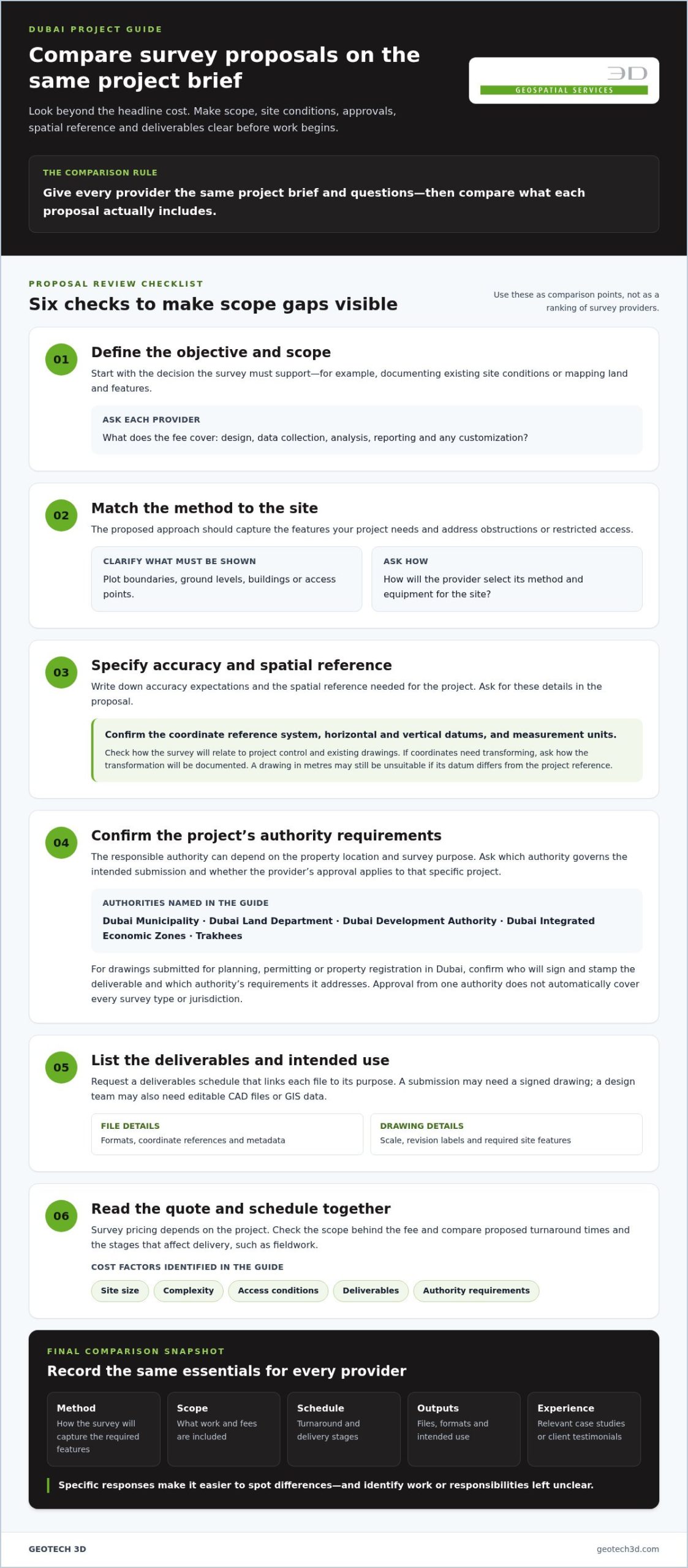
Use the same project brief and questions with each survey provider, then compare what each response includes. Start by defining the decision the survey must support, such as documenting existing site conditions or mapping land and features. Ask each Dubai provider to explain its proposed scope, method, schedule, outputs and assumptions. Consistent inputs make differences between proposals easier to spot.
Ask how the provider will turn your objective into a workable survey or questionnaire. A survey is the broader data-collection process; a questionnaire is the structured set of questions used within it. For example, a customer satisfaction survey might use a short questionnaire after a service interaction. Agree on the target audience, collection method, and how findings will be presented before comparing proposals.
- Ask what each fee covers, including design, data collection, analysis, reporting, and any customization.
- Compare proposed turnaround times and the stages that affect delivery, such as fieldwork or response collection.
- Ask for relevant case studies or client testimonials to assess experience with similar work.
- Confirm which outputs will support your decision, such as a findings report, mapped data, or drawings.
The survey method affects the information collected. Ask how the provider will capture the features your project needs and deal with obstructions or restricted access. For example, clarify whether the survey must show plot boundaries, ground levels, buildings or access points. The right approach depends on the site and the decisions the survey will support.
Ask how questions are ordered and reviewed before launch. Designers commonly begin with straightforward, non-intrusive questions before introducing detailed or sensitive topics. They should define objectives first, keep the questionnaire focused, and pre-test it with a small group to catch confusing wording. Survey participants should also be told the purpose, how their data will be used, and their rights. Federal Decree-Law No. 45 of 2021 governs personal data processing in the UAE, according to UAE legislation portal.
What risks or red flags should I watch for when hiring a survey provider in Dubai? Watch for vague answers about scope, question design, data use, or deliverables, and proposals that do not connect the method to your stated objective. Leading questions, unclear participant information, and unsupported claims about results also deserve scrutiny.
Use a comparison table to record each provider’s method, scope, schedule, outputs and relevant experience. When evaluating survey providers in Dubai, check whether each response is specific enough to assess against the same project requirements. This makes it easier to distinguish a tailored proposal from one that leaves important work or responsibilities unclear.
Coordinate systems and authority-compliant deliverables
A survey is useful only when its spatial reference and output suit the project. In Dubai, requirements can depend on the property’s location, the survey’s purpose and the authority responsible for submission. Ask the provider to identify the coordinate reference system, horizontal and vertical datums, and measurement units proposed for your site. These details help prevent mismatches when survey data is combined with design, GIS or construction information.
Request coordinate-system details in writing. Ask how the survey will relate to project control and existing drawings. If the design team uses a different reference, ask how coordinates will be transformed and documented. For example, a drawing delivered in metres may still be unsuitable if its datum differs from the project’s established reference. Clear metadata makes this distinction visible during review.
Authority requirements need separate attention. Dubai projects may involve Dubai Municipality, Dubai Land Department, Dubai Development Authority, Dubai Integrated Economic Zones or Trakhees, depending on location and project type. Approval from one authority does not automatically establish approval for every survey type or jurisdiction. Ask which authority governs the intended submission and whether the provider’s approval applies to that project.
For drawings submitted for planning, permitting or property registration in Dubai, the survey must be stamped by a surveyor registered with the relevant authority. A survey company without registration from the authority overseeing the project cannot legally stamp its drawings, and the submission may be rejected regardless of survey quality. Confirm who will sign and stamp the deliverable, and which authority’s requirements it will address.
Request a deliverables schedule that links each file to its intended use. A submission package may require a signed drawing, while a design team may also need editable CAD files or GIS data. Specify file formats, coordinate references, drawing scale, revision labels and accompanying metadata. For example, state whether the drawing must show plot boundaries, existing features or access points. A structured schedule reduces ambiguity between the survey team, consultant and reviewer.
- Match the coordinate system and units to the project’s existing design information.
- Identify the authority responsible for the specific site and submission.
- Record who prepares, checks, signs, and stamps each required drawing.
- List every file, format, and revision expected at handover.
Dubai Municipality maintains an approved list of survey companies, while the Dubai Land Department provides a directory labelled “Accredited surveying companies.” Other authorities maintain their own approval lists. Treat this as project-specific due diligence, not a general credential check. A clear brief can also make Dubai surveying project requirements easier to discuss with the relevant team before submission.
Before accepting the final package, compare its coordinate notes and authority details with the agreed scope. This final review helps confirm technical consistency and submission readiness, and can reveal missing metadata or signature requirements before the drawings enter a planning, permitting or registration workflow.
What questions should I ask about survey methods, accuracy, and deliverables?
Ask how the proposed method fits the site, required detail, and intended use. A boundary survey, construction setting-out task, and existing-conditions survey require different observations. Ask which instruments will be used and why they suit the work. Depending on the survey, Dubai providers may use total stations, GNSS/GPS equipment, digital levels, or 3D laser scanners. The method should follow the task, not simply the equipment available.
Request an accuracy specification before fieldwork. Ask how accuracy will be measured, checked and reported, and what limitations could affect the result. For Dubai setting-out and as-built work, survey-grade total stations and GNSS receivers should achieve millimetre-level accuracy. Ask the provider to state the required project tolerance and explain how the proposed method addresses it. A general claim of “high accuracy” is not a measurable acceptance criterion.
Equipment condition and field supervision also matter. Ask whether instruments are calibrated and whether calibration records are available for the project’s quality review. Find out who supervises fieldwork and whether that person is a qualified surveyor. Ask how the team checks observations before leaving the site. A documented review of control points and measurements, for example, can help catch field errors before they affect drawings or design.
Deliverables should make the results usable, not merely record that fieldwork took place. Ask whether the handover includes drawings, data files, metadata, an accuracy report and notes on limitations. Where applicable, accuracy reporting should include RMSE values and enough context to interpret them. Confirm file formats and naming conventions against the receiving team’s workflow. A design consultant may need editable CAD data, while an asset team may require structured spatial data.
- Ask which field method and instruments suit the site and survey objective.
- Set the accuracy requirement and ask how the provider will demonstrate it.
- Request calibration evidence, field-supervision responsibilities, and quality-check steps.
- List each required file, report, metadata item, and limitation in the deliverables schedule.
Timing needs a defined start and finish point. A stated turnaround could refer to fieldwork, draft drawings, or the checked final package. Ask which stages the schedule covers and how site access or complex processing affects delivery. A Dubai survey reference describes 24-72 hours as a reasonable field-to-drawing turnaround for most survey types. Treat that as a comparison point, then assess the quoted schedule against the actual scope and review requirements.
For a land survey, site size, access, fieldwork and drawing complexity influence the method and outputs. Ask how revisions are handled if a review identifies missing information. A useful proposal links each method to a specified deliverable and acceptance check. This makes technical differences between providers visible and helps you assess whether the final data will support the next project decision.
What insurance and liability coverage should a survey provider in Dubai carry?
Review insurance against the survey scope, site environment and contract responsibilities. There is no single coverage package for every Dubai project. Ask the provider to identify its active policies and explain what each covers. Fieldwork inside an operating building, for example, creates different exposure from a survey of an unoccupied plot. Compare the proposed work with the relevant policy wording, not just the certificate title.
Professional indemnity insurance is relevant to claims alleging errors in professional services. Ask whether the policy covers the surveying activities in your scope, such as measurement, mapping or drawing preparation. Clarify how the insurer treats correction costs, third-party claims and allegations of negligent work. A certificate alone may not explain exclusions, so review the applicable wording with your project’s procurement or risk team.
Public liability coverage addresses a different exposure: third-party injury or property damage connected with operations. Discuss site-specific examples, such as equipment contacting a finished surface or a visitor entering a work area. Ask whether the policy applies at the project location and during the planned field activities. For work in an occupied building, clarify how access arrangements and site controls align with the contract’s responsibilities.
Establish which entity and personnel the coverage protects. The named insured should match the contracting party, and the project scope should include relevant subcontracted work. Ask how the provider manages field teams, vehicles and specialist subcontractors. If a subcontractor performs part of the survey, clarify which party is responsible for its work and how that arrangement is documented.
- Request current insurance certificates and the policy period for each relevant policy.
- Compare the named insured with the legal entity signing the Dubai project contract.
- Review exclusions, geographic scope, deductibles, and claims-notification requirements.
- Record how subcontractors, field personnel, and site activities are covered.
Liability clauses need as much attention as insurance documents. Identify who is responsible for inaccurate information, property damage, delays caused by site access and third-party claims. For example, distinguish an error in a survey deliverable from a later design change made by another project party. Ask how the contract handles notice, investigation, correction and dispute resolution. Clear allocation reduces the risk of conflicting interpretations after an incident.
Assess coverage limits against the project’s contract value, site risks and potential consequences, rather than relying on a generic figure. Record agreed insurance evidence and responsibility terms before fieldwork starts. This gives the project manager, risk team and provider a practical reference throughout delivery.
What should a Dubai survey quotation and contract include?
A clear quotation links the project brief to defined work, costs, timing and deliverables. For a Dubai land survey, ask whether the price covers the site visit, measurements, drawings, reports, submission assistance and required revisions. Mark each item as included, excluded or conditional. If drawings are included but authority submission is not, for example, the quotation should state who handles submission.
The scope should identify the site, survey purpose, access assumptions, and expected outputs. It should also describe fieldwork and any processing or review stages. A land survey’s cost depends on survey type, site size, complexity, access conditions, deliverables, and authority requirements. The price depends on the case and is given after a quote request, with these factors shaping the scope. Compare proposals against the same requirements rather than choosing solely by headline amount.
Ask for a schedule with clear milestones, such as site work, draft drawings, review and final handover. Confirm the anticipated completion date and the events that could affect it, including restricted access or changes to the requested scope. The contract should explain whether additional work requires a revised quotation and written approval. This keeps extra site measurements from becoming an undefined cost or schedule change.
- Define the site boundary, survey objective, access arrangements, and client-provided information.
- List measurements, drawings, reports, file formats, and submission support included.
- State the planned schedule, review stages, and client responsibilities.
- Explain how revisions, scope changes, and additional work affect fees and timing.
Address authority requirements specifically in the contract. Identify the authority relevant to the project and the approval status required for the intended survey. State whether the provider prepares submission documents, manages Dubai Municipality e-submission or responds to reviewer correspondence. If the client handles submission, assign that responsibility clearly. Explain how requested corrections will be assessed and what process applies if an authority asks for revisions.
Before signing, check that the quotation and contract describe the same scope, deliverables, schedule and payment terms. A report listed in the proposal but omitted from the contract, for example, can create avoidable disagreement. Record how variations will be approved and revised documents issued. Keep the final quotation, contract and project brief together so the team can resolve scope questions against one consistent record.
GEOTECH 3D: topo survey
GEOTECH 3D provides topo surveys for projects that need a clear record of existing site conditions. A topographic survey can help teams understand ground levels and visible features when planning development, design, or construction work. It is a relevant next step when your project requires site information to inform drawings or decisions.
The right scope depends on the intended use. Define the site area, required features, coordinate system, accuracy expectations, and deliverable formats in the brief. For complex existing structures, 3D Laser Scanning may also be relevant; Drone Services and GIS & Surveying Services can address other data-acquisition or mapping needs.
Share your project requirements with GEOTECH 3D or visit geotech3d.com.
Turn your survey requirements into a clear project brief
Before commissioning work, capture the project’s intended decision, site information and required handover in one concise brief. This gives your team a shared reference and helps align procurement, technical review and delivery. Knowing what to ask when evaluating survey providers in Dubai is most useful when the questions reflect how your team will use the results.
Assign an internal owner to review the proposal and accept the completed work. That person can coordinate input from project management, design, procurement and any relevant authority-facing team. A consistent review process helps surface changes early, before they affect scope or programme. Use the brief as a working document and update it when project requirements change.
With a defined scope and decision pathway, you can move forward with greater clarity and keep the survey aligned with the project’s next stage.
A well-framed brief is a strong starting point for confident project decisions.
Frequently Asked Questions
How is measurement accuracy maintained?
Accuracy alone does not show whether a survey captures everything your project needs. Ask how the provider will ensure the required features are observed, especially where structures, vegetation or restricted areas limit visibility. A site model may contain precise measurements but omit a concealed or obstructed area. Discuss coverage alongside precision, and identify areas needing separate access or treatment before work begins.
What equipment will be used?
Ask how site conditions influence equipment choice and the field plan. Buildings, narrow spaces, reflective surfaces and obstructions can affect where observations are possible. GNSS reception and line of sight may also influence how a team works across a site. Ask what the provider will do if the planned setup cannot capture a required area, and how any adjustment will be recorded for project review.
What qualifications and licenses should a survey provider in Dubai have?
Ask who will lead the field team and who is accountable for technical review. Request role-specific information about the survey lead’s qualifications and experience with your project type, rather than relying only on a company profile. Complex building interiors, for example, may require different practical experience from open-site work. Clarify who will answer technical questions during delivery and address concerns raised by your project team.
How can I verify a Dubai survey company’s credentials and track record?
Ask for evidence of the provider’s actual role, not just a project name. Request a relevant example with sensitive details removed, then assess whether its scope and level of detail resemble your requirements. Check how the provider explains constraints, changes and handover responsibilities. For a reference project, establish what work the company performed and which outputs it delivered. This helps distinguish direct experience from a general association with a project.
How do Dubai survey providers handle permits, site access, and utility coordination?
Ask how site entry and coordination will be organized among the owner, contractor, facilities team and survey crew. Agree who arranges inductions, escorts, work-area access and scheduling with site operations. For utility-related work, identify who supplies existing records and coordinates access to relevant areas. A responsibility matrix can clarify these interfaces, particularly where active construction or occupied premises limit when field teams can work.
How do survey providers in Dubai compare on technology, equipment, and reporting formats?
Compare how each provider manages the data workflow, from field capture through review and handover. Ask how files are organized, revisions are distinguished and reported findings can be traced to their source data. A short walkthrough of a sample workflow using your team’s typical review process can reveal whether the technology supports coordination and decision-making, beyond simply describing instruments or software.

The lowest quote is not necessarily the best fit for a Dubai project. Knowing what to ask when evaluating survey providers in Dubai means comparing the scope, site conditions, required approvals, coordinate system and final deliverables, not just the headline cost. Price depends on the project and is provided after a quote request; key cost factors include site size, complexity, access conditions, deliverables and authority requirements.
It is reasonable to want a clear budget and confidence that the survey will meet its purpose. A useful comparison makes those expectations explicit, so you can see what each proposal covers and identify scope differences before work begins.
This guide explains how to define survey objectives, establish whether project-specific approval applies, and clarify accuracy, coordinate systems, schedules and deliverables. It also covers the cost and contract questions that help you assess proposals against your requirements.
Key Takeaways
- Compare quotes by scope, site conditions, deliverables, and authority requirements, not by headline cost alone.
- Establish which authority’s requirements apply to the project and whether the survey provider’s approval covers that specific survey and location.
- Align the survey objective, coordinate system, accuracy expectations, and final file formats before fieldwork begins.
- Review how the provider will select methods and equipment, supervise fieldwork, and document limitations and accuracy.
- Clarify what the quotation includes, how scope changes affect fees, and how insurance and liability responsibilities are addressed in the contract.
Questions to compare providers consistently
Use the same project brief and questions with each survey provider, then compare what each response includes. Start by defining the decision the survey must support, such as documenting existing site conditions or mapping land and features. Ask each Dubai provider to explain its proposed scope, method, schedule, outputs and assumptions. Consistent inputs make differences between proposals easier to spot.
Ask how the provider will turn your objective into a workable survey or questionnaire. A survey is the broader data-collection process; a questionnaire is the structured set of questions used within it. For example, a customer satisfaction survey might use a short questionnaire after a service interaction. Agree on the target audience, collection method, and how findings will be presented before comparing proposals.
- Ask what each fee covers, including design, data collection, analysis, reporting, and any customization.
- Compare proposed turnaround times and the stages that affect delivery, such as fieldwork or response collection.
- Ask for relevant case studies or client testimonials to assess experience with similar work.
- Confirm which outputs will support your decision, such as a findings report, mapped data, or drawings.
The survey method affects the information collected. Ask how the provider will capture the features your project needs and deal with obstructions or restricted access. For example, clarify whether the survey must show plot boundaries, ground levels, buildings or access points. The right approach depends on the site and the decisions the survey will support.
Ask how questions are ordered and reviewed before launch. Designers commonly begin with straightforward, non-intrusive questions before introducing detailed or sensitive topics. They should define objectives first, keep the questionnaire focused, and pre-test it with a small group to catch confusing wording. Survey participants should also be told the purpose, how their data will be used, and their rights. Federal Decree-Law No. 45 of 2021 governs personal data processing in the UAE, according to UAE legislation portal.
What risks or red flags should I watch for when hiring a survey provider in Dubai? Watch for vague answers about scope, question design, data use, or deliverables, and proposals that do not connect the method to your stated objective. Leading questions, unclear participant information, and unsupported claims about results also deserve scrutiny.
Use a comparison table to record each provider’s method, scope, schedule, outputs and relevant experience. When evaluating survey providers in Dubai, check whether each response is specific enough to assess against the same project requirements. This makes it easier to distinguish a tailored proposal from one that leaves important work or responsibilities unclear.
Coordinate systems and authority-compliant deliverables
A survey is useful only when its spatial reference and output suit the project. In Dubai, requirements can depend on the property’s location, the survey’s purpose and the authority responsible for submission. Ask the provider to identify the coordinate reference system, horizontal and vertical datums, and measurement units proposed for your site. These details help prevent mismatches when survey data is combined with design, GIS or construction information.
Request coordinate-system details in writing. Ask how the survey will relate to project control and existing drawings. If the design team uses a different reference, ask how coordinates will be transformed and documented. For example, a drawing delivered in metres may still be unsuitable if its datum differs from the project’s established reference. Clear metadata makes this distinction visible during review.
Authority requirements need separate attention. Dubai projects may involve Dubai Municipality, Dubai Land Department, Dubai Development Authority, Dubai Integrated Economic Zones or Trakhees, depending on location and project type. Approval from one authority does not automatically establish approval for every survey type or jurisdiction. Ask which authority governs the intended submission and whether the provider’s approval applies to that project.
For drawings submitted for planning, permitting or property registration in Dubai, the survey must be stamped by a surveyor registered with the relevant authority. A survey company without registration from the authority overseeing the project cannot legally stamp its drawings, and the submission may be rejected regardless of survey quality. Confirm who will sign and stamp the deliverable, and which authority’s requirements it will address.
Request a deliverables schedule that links each file to its intended use. A submission package may require a signed drawing, while a design team may also need editable CAD files or GIS data. Specify file formats, coordinate references, drawing scale, revision labels and accompanying metadata. For example, state whether the drawing must show plot boundaries, existing features or access points. A structured schedule reduces ambiguity between the survey team, consultant and reviewer.
- Match the coordinate system and units to the project’s existing design information.
- Identify the authority responsible for the specific site and submission.
- Record who prepares, checks, signs, and stamps each required drawing.
- List every file, format, and revision expected at handover.
Dubai Municipality maintains an approved list of survey companies, while the Dubai Land Department provides a directory labelled “Accredited surveying companies.” Other authorities maintain their own approval lists. Treat this as project-specific due diligence, not a general credential check. A clear brief can also make Dubai surveying project requirements easier to discuss with the relevant team before submission.
Before accepting the final package, compare its coordinate notes and authority details with the agreed scope. This final review helps confirm technical consistency and submission readiness, and can reveal missing metadata or signature requirements before the drawings enter a planning, permitting or registration workflow.
What questions should I ask about survey methods, accuracy, and deliverables?
Ask how the proposed method fits the site, required detail, and intended use. A boundary survey, construction setting-out task, and existing-conditions survey require different observations. Ask which instruments will be used and why they suit the work. Depending on the survey, Dubai providers may use total stations, GNSS/GPS equipment, digital levels, or 3D laser scanners. The method should follow the task, not simply the equipment available.
Request an accuracy specification before fieldwork. Ask how accuracy will be measured, checked and reported, and what limitations could affect the result. For Dubai setting-out and as-built work, survey-grade total stations and GNSS receivers should achieve millimetre-level accuracy. Ask the provider to state the required project tolerance and explain how the proposed method addresses it. A general claim of “high accuracy” is not a measurable acceptance criterion.
Equipment condition and field supervision also matter. Ask whether instruments are calibrated and whether calibration records are available for the project’s quality review. Find out who supervises fieldwork and whether that person is a qualified surveyor. Ask how the team checks observations before leaving the site. A documented review of control points and measurements, for example, can help catch field errors before they affect drawings or design.
Deliverables should make the results usable, not merely record that fieldwork took place. Ask whether the handover includes drawings, data files, metadata, an accuracy report and notes on limitations. Where applicable, accuracy reporting should include RMSE values and enough context to interpret them. Confirm file formats and naming conventions against the receiving team’s workflow. A design consultant may need editable CAD data, while an asset team may require structured spatial data.
- Ask which field method and instruments suit the site and survey objective.
- Set the accuracy requirement and ask how the provider will demonstrate it.
- Request calibration evidence, field-supervision responsibilities, and quality-check steps.
- List each required file, report, metadata item, and limitation in the deliverables schedule.
Timing needs a defined start and finish point. A stated turnaround could refer to fieldwork, draft drawings, or the checked final package. Ask which stages the schedule covers and how site access or complex processing affects delivery. A Dubai survey reference describes 24-72 hours as a reasonable field-to-drawing turnaround for most survey types. Treat that as a comparison point, then assess the quoted schedule against the actual scope and review requirements.
For a land survey, site size, access, fieldwork and drawing complexity influence the method and outputs. Ask how revisions are handled if a review identifies missing information. A useful proposal links each method to a specified deliverable and acceptance check. This makes technical differences between providers visible and helps you assess whether the final data will support the next project decision.
What insurance and liability coverage should a survey provider in Dubai carry?
Review insurance against the survey scope, site environment and contract responsibilities. There is no single coverage package for every Dubai project. Ask the provider to identify its active policies and explain what each covers. Fieldwork inside an operating building, for example, creates different exposure from a survey of an unoccupied plot. Compare the proposed work with the relevant policy wording, not just the certificate title.
Professional indemnity insurance is relevant to claims alleging errors in professional services. Ask whether the policy covers the surveying activities in your scope, such as measurement, mapping or drawing preparation. Clarify how the insurer treats correction costs, third-party claims and allegations of negligent work. A certificate alone may not explain exclusions, so review the applicable wording with your project’s procurement or risk team.
Public liability coverage addresses a different exposure: third-party injury or property damage connected with operations. Discuss site-specific examples, such as equipment contacting a finished surface or a visitor entering a work area. Ask whether the policy applies at the project location and during the planned field activities. For work in an occupied building, clarify how access arrangements and site controls align with the contract’s responsibilities.
Establish which entity and personnel the coverage protects. The named insured should match the contracting party, and the project scope should include relevant subcontracted work. Ask how the provider manages field teams, vehicles and specialist subcontractors. If a subcontractor performs part of the survey, clarify which party is responsible for its work and how that arrangement is documented.
- Request current insurance certificates and the policy period for each relevant policy.
- Compare the named insured with the legal entity signing the Dubai project contract.
- Review exclusions, geographic scope, deductibles, and claims-notification requirements.
- Record how subcontractors, field personnel, and site activities are covered.
Liability clauses need as much attention as insurance documents. Identify who is responsible for inaccurate information, property damage, delays caused by site access and third-party claims. For example, distinguish an error in a survey deliverable from a later design change made by another project party. Ask how the contract handles notice, investigation, correction and dispute resolution. Clear allocation reduces the risk of conflicting interpretations after an incident.
Assess coverage limits against the project’s contract value, site risks and potential consequences, rather than relying on a generic figure. Record agreed insurance evidence and responsibility terms before fieldwork starts. This gives the project manager, risk team and provider a practical reference throughout delivery.
What should a Dubai survey quotation and contract include?
A clear quotation links the project brief to defined work, costs, timing and deliverables. For a Dubai land survey, ask whether the price covers the site visit, measurements, drawings, reports, submission assistance and required revisions. Mark each item as included, excluded or conditional. If drawings are included but authority submission is not, for example, the quotation should state who handles submission.
The scope should identify the site, survey purpose, access assumptions, and expected outputs. It should also describe fieldwork and any processing or review stages. A land survey’s cost depends on survey type, site size, complexity, access conditions, deliverables, and authority requirements. The price depends on the case and is given after a quote request, with these factors shaping the scope. Compare proposals against the same requirements rather than choosing solely by headline amount.
Ask for a schedule with clear milestones, such as site work, draft drawings, review and final handover. Confirm the anticipated completion date and the events that could affect it, including restricted access or changes to the requested scope. The contract should explain whether additional work requires a revised quotation and written approval. This keeps extra site measurements from becoming an undefined cost or schedule change.
- Define the site boundary, survey objective, access arrangements, and client-provided information.
- List measurements, drawings, reports, file formats, and submission support included.
- State the planned schedule, review stages, and client responsibilities.
- Explain how revisions, scope changes, and additional work affect fees and timing.
Address authority requirements specifically in the contract. Identify the authority relevant to the project and the approval status required for the intended survey. State whether the provider prepares submission documents, manages Dubai Municipality e-submission or responds to reviewer correspondence. If the client handles submission, assign that responsibility clearly. Explain how requested corrections will be assessed and what process applies if an authority asks for revisions.
Before signing, check that the quotation and contract describe the same scope, deliverables, schedule and payment terms. A report listed in the proposal but omitted from the contract, for example, can create avoidable disagreement. Record how variations will be approved and revised documents issued. Keep the final quotation, contract and project brief together so the team can resolve scope questions against one consistent record.
GEOTECH 3D: topo survey
GEOTECH 3D provides topo surveys for projects that need a clear record of existing site conditions. A topographic survey can help teams understand ground levels and visible features when planning development, design, or construction work. It is a relevant next step when your project requires site information to inform drawings or decisions.
The right scope depends on the intended use. Define the site area, required features, coordinate system, accuracy expectations, and deliverable formats in the brief. For complex existing structures, 3D Laser Scanning may also be relevant; Drone Services and GIS & Surveying Services can address other data-acquisition or mapping needs.
Share your project requirements with GEOTECH 3D or visit geotech3d.com.
Turn your survey requirements into a clear project brief
Before commissioning work, capture the project’s intended decision, site information and required handover in one concise brief. This gives your team a shared reference and helps align procurement, technical review and delivery. Knowing what to ask when evaluating survey providers in Dubai is most useful when the questions reflect how your team will use the results.
Assign an internal owner to review the proposal and accept the completed work. That person can coordinate input from project management, design, procurement and any relevant authority-facing team. For complex developments that require broader project management advisory, organisations often partner with LR Consultants to ensure procurement standards and operational delivery stay aligned. A consistent review process helps surface changes early, before they affect scope or programme. Use the brief as a working document and update it when project requirements change.
With a defined scope and decision pathway, you can move forward with greater clarity and keep the survey aligned with the project’s next stage.
A well-framed brief is a strong starting point for confident project decisions.
Frequently Asked Questions
How is measurement accuracy maintained?
Accuracy alone does not show whether a survey captures everything your project needs. Ask how the provider will ensure the required features are observed, especially where structures, vegetation or restricted areas limit visibility. A site model may contain precise measurements but omit a concealed or obstructed area. Discuss coverage alongside precision, and identify areas needing separate access or treatment before work begins.
What equipment will be used?
Ask how site conditions influence equipment choice and the field plan. Buildings, narrow spaces, reflective surfaces and obstructions can affect where observations are possible. GNSS reception and line of sight may also influence how a team works across a site. Ask what the provider will do if the planned setup cannot capture a required area, and how any adjustment will be recorded for project review.
What qualifications and licenses should a survey provider in Dubai have?
Ask who will lead the field team and who is accountable for technical review. Request role-specific information about the survey lead’s qualifications and experience with your project type, rather than relying only on a company profile. Complex building interiors, for example, may require different practical experience from open-site work. Clarify who will answer technical questions during delivery and address concerns raised by your project team.
How can I verify a Dubai survey company’s credentials and track record?
Ask for evidence of the provider’s actual role, not just a project name. Request a relevant example with sensitive details removed, then assess whether its scope and level of detail resemble your requirements. Check how the provider explains constraints, changes and handover responsibilities. For a reference project, establish what work the company performed and which outputs it delivered. This helps distinguish direct experience from a general association with a project.
How do Dubai survey providers handle permits, site access, and utility coordination?
Ask how site entry and coordination will be organized among the owner, contractor, facilities team and survey crew. Agree who arranges inductions, escorts, work-area access and scheduling with site operations. For utility-related work, identify who supplies existing records and coordinates access to relevant areas. A responsibility matrix can clarify these interfaces, particularly where active construction or occupied premises limit when field teams can work.
How do survey providers in Dubai compare on technology, equipment, and reporting formats?
Compare how each provider manages the data workflow, from field capture through review and handover. Ask how files are organized, revisions are distinguished and reported findings can be traced to their source data. A short walkthrough of a sample workflow using your team’s typical review process can reveal whether the technology supports coordination and decision-making, beyond simply describing instruments or software.
Search Now
Error: Contact form not found.